
 Worksheets
SJVN Limited (ArcGIS and RS Training Program)
Total questions: 60
Worksheet time: 45mins
How is a globe more accurate than a map?
a globe is a 3 dimensional model of the Earth, but a map is flat
a globe can show streets and roads, but a map cannot
a globe can show all of the continents at once, but a map cannot
a globe can be used to navigate from one town to another, but a map cannot
Maps are the least useful tool in geography.
True
False
Google maps is an example of a GIS.
True
False
Which of the following is not a hardware component of GIS?
A computer screen
GPS coordinates
A plotter
A scanner
Multiuser editing capability is available in which of the following geodatabase?
Personal geodatabase
File geodatabase
Enterprise geodatabase
None of the above
By ‘spatial data’ we mean data that has:
Complex values
Location/coordinate values
Graphic values
Decimal values
Which of the following is used to extract features and their attributes from one layer using a polygon from another as the boundary of the output?
Join
Merge
Union
Clip
What is ‘Attribute data’?
Specifies characteristics at that location, natural or human-created
Can be stored in a database table
Both A and B
None of the above
Numerous employees in your organization need access to the streets data that your team is responsible for maintaining in an enterprise database. From the options given below, what is the best way to handle access to these data? (Choose the best response)
Set the streets layer’s permissions to allow everyone in your enterprise full control
Set the streets layer’s permission to allow full control only to your team
Set the streets layer’s permission to allow full control only to your team and read-only access to the remainder of your enterprise
No action needed
The conventional sign for cultivated land on a topographic map is an example of ...
point data
line data
polygon data
Vector data is easier to store on a computer as it takes less file space.
TRUE
FALSE
Meta data would describe....
who collected a set of data.
how the data was collected.
when the data was collected.
all of the above are true.
Attribute data could be collected via a survey.
True
False

Match the following related to Electromagnetic dis- tance measurement (EDM):
b c a
a c b
c a b
a b c
The minimum number of satellites needed for a GPS to determine its position precisely is
2
3
4
24
The system that uses the Sun as a source of electro- magnetic energy and records the naturally radiated and reflected energy from the object is called
Geographical information system
Global Positioning System
Passive Remote Sensing
Active Remote Sensing
Spencer wants to use the same logo on my website for my business cards and letterhead. I should use a ____________ image and should be at least ________________.
raster; 72 dpi
raster; 300 ppi
vector; 300 dpi
vector; 72 ppi
Input feature geometry replaced by another layer
Update
Union
Merge
None

What is the function that the image represent?
Raster Overlay
Feature Overlay
Overlay analysis
Combine
If the zone input is a feature dataset, a vector-to-raster conversion will be internally applied to it. To ensure that the results of the conversion will align properly with the value raster, it is recommended that you check to ensure the extent and snap raster are set appropriately in the environment settings and the raster settings.
Since the internal raster must have an attribute table, an error will occur if one was not created in the conversion. If this happens, convert your feature dataset directly with_______
Spatial data is ...
data that describes the shape and location on an entity.
data that describes the characteristics of an entity.
The range of wavelengths a device is able to capture is called the ...
temporal resolution
spatial resolution
spectral resolution
Vector data is easier to store on a computer as it takes less file space.
TRUE
FALSE
Attribute data could be collected via a survey.
True
False
why the Use of GIS is necessary
Saves Times
Handle large datasets
Maps can be created and edited faster
All of the above
How is a globe more accurate than a map?
a globe is a 3 dimensional model of the Earth, but a map is flat
a globe can show streets and roads, but a map cannot
a globe can show all of the continents at once, but a map cannot
a globe can be used to navigate from one town to another, but a map cannot
GIS deals with which kind of data
Numeric data
Binary data
Spatial data
Complex data
A visual representation of an area
globe
map
aerial photograph
GPS
What is GIS in the most encompassing sense?
A software to make maps
System designed to capture, store, manipulate, analyze, manage and present all types of geographic
Application to collect data on the field and store in database
Tool to edit and design maps for visualization
By 'spatial data', we mean data that has
Complex values
Positional values
Graphic values
Decimal values
Key components of 'spatial data' quality include
Positional accuracy
Temporal accuracy
Lineage and completeness
Logical consistency
All of the above
'Spatial databases' are also known as
Geodatabases
Monodatabases
Concurrent databases
None of the above
Successful spatial analysis needs
Appropriate software
Appropriate hardware
Competent user
All of the above
True or false: The cartographer’s purpose and the projection used to create a map influence what information is accurate and what is distorted.
True
False
True or false: All world map projections create distorted images of the Earth to some degree. These distortions relate to size, shape, direction, and distance.
True
False
A way of representing the spherical Earth on a flat surface:
Projection
Distortion
Cartographer
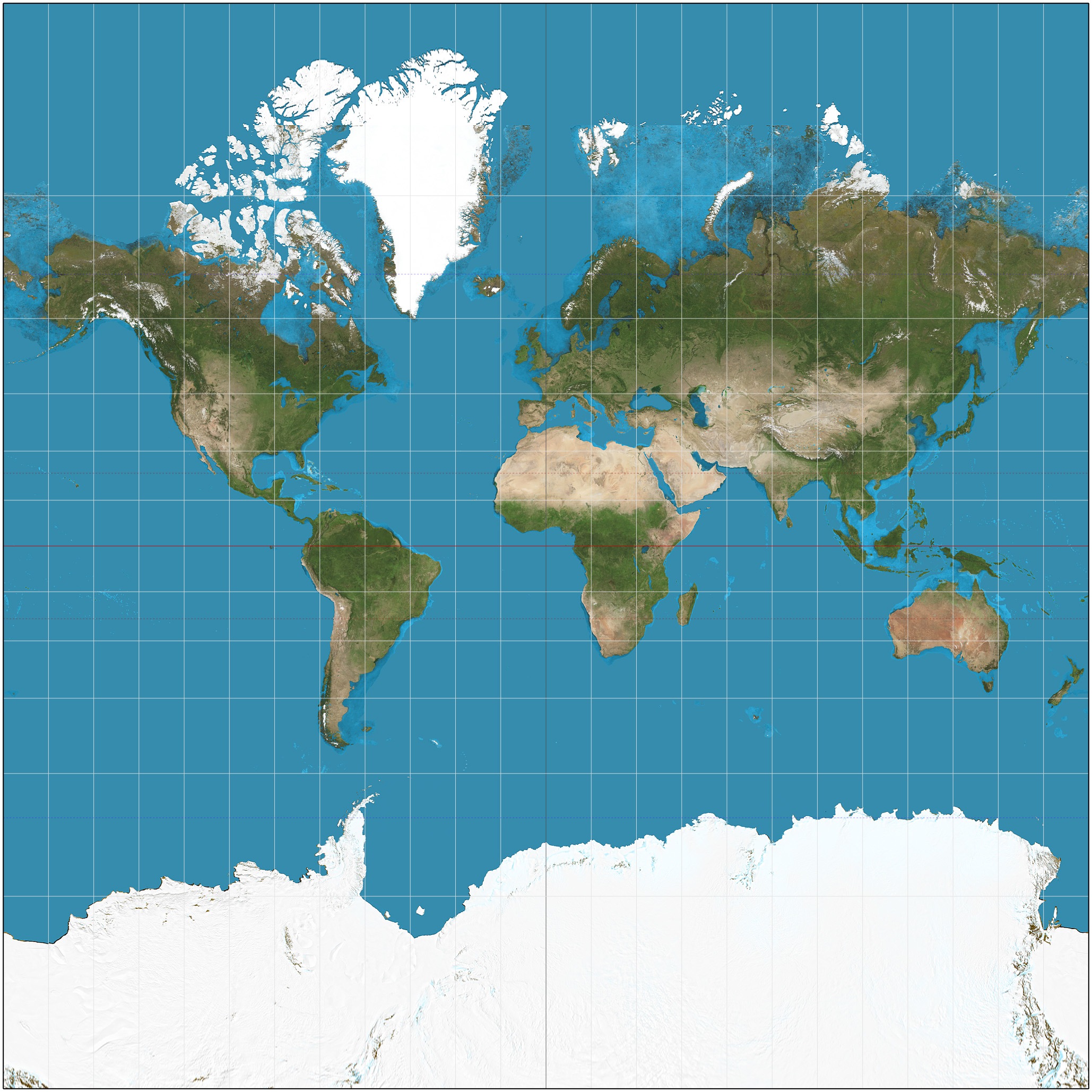
Which projection is this?
Gall Peter's
Robinson
Mercator
Which map projection's shape and direction are accurate but size is very distorted?
Robinson
Gall Peter's
Mercator
Why are there so many types of map projections and why do they all look so different?
They are all made for different purposes
Cartographers get bored and make new maps
To confuse students
The GIS is used to study ______________ analyze soils and strata, assess seismic information, and or create three dimensional (3D) displays of _________.
geologic features, locaton
geologic features, geographic features
hydrology, geographic features
All the above
The environment data for various development initiatives are created and stored in multiple GIS formats.
True
False
GIS Application can determine the land use / land cover changes in different areas based on land cover pattern within time.
True
False
_____ is the collection of data that does not involve physical contact
GPS
Fieldwork
Remote-sensing
Not opening your textbook
Healthy vegetation reflects energy in what parts of the electromagnetic spectrum?
Blue and Green
Green and Near-Infrared
Blue and Red
Green and Red
Water appears blue because shorter visible wavelengths (blue) are absorbed more than longer visible wavelengths (green and red) and near-IR radiation.
True
False
Non-polar orbiting satellites do not provide global coverage.
False
True
Passive remote sensing is where instruments emit a signal and the sensor measures what is reflected back.
True
False
What is the relationship between spatial resolution and spatial extent in satellite imagery?
low spatial resolution = greater spatial extent
high spatial resolution = greater spatial extent
When light is reflected off a surface, it is detected by passive remote sensing satellites and produces a(n) ________________, which we use to identify different surfaces.
Rainbow
Pulsar
Spectral Signatures
Awe inspiring moment
T or F: Remote sensing can be used to monitor changes on the Earth's surface over time.
True
False
Not Sure
What geographic tool uses at least four satellites to provide locations on the Earth?
globe
map
satellite imagery
GPS
You can add information onto a GIS map by...
Choosing different layers
Choosing different laminates
Adding data from a table
Researching from the internet
Which of these is not a component of a GIS?
Hardware
Software
Users
Maps
Data

