wayground logo

Free Printable Worksheets

Font size

S
M
L
XL
Worksheets

FINAL EXAM ES REVIEW

Total questions: 50

Worksheet time: 2hrs 43mins

Name
Class
Date
1.

Which natural event periodically weakens western surface ocean currents in the equatorial Pacific

Ocean, resulting in a change in air temperature

and precipitation patterns in the United States?

a)

El Nin ̃o

b)

transpiration

c)

ocean tides

d)

volcanic eruptions

2.
Which type of rock forms from extreme heat and pressure?
a)
Igneous
b)
Sedimentary
c)
Organic
d)
Metamorphic
3.
Wind, water, and ice breaking down rock is called
a)
Erosion
b)
Deposition
c)
Compaction
d)
Weathering
4.
This rock is made from tiny pieces of other rocks that settled to the bottom of a valley millions of years ago. What type of rock is this?
a)
Sedimentary
b)
Igneous
c)
Metamorphic
5.
This rock started as molten magma. What type of rock is this?
a)
Sedimentary
b)
Igneous
c)
Metamorphic
6.
In which two temperature zones of the atmosphere does the temperature increase with increasing altitude?
a)
troposphere and stratosphere
b)
troposphere and mesosphere
c)
stratosphere and thermosphere
d)
mesosphere and thermosphere
7.
Which type of air mass would most likely form over the northern Pacific Ocean?
a)
mP
b)
cP
c)
mT
d)
cT
8.

Summer monsoon rains normally occur in India when

a)

high pressure exists over land, pulling moisture in from the Indian Ocean

b)

high pressure exists over land, pushing moisture out to the Indian Ocean

c)

low pressure exists over land pulling moisture in from the Indian Ocean

d)

low pressure exists over land pushing moisture out to the Indian Ocean

9.
In which layer of the atmosphere is most water vapor found?
a)
thermosphere
b)
mesosphere
c)
stratosphere
d)
troposphere
10.

Which locations are most likely experiencing precipitation?

a)

D and B

b)

C and D

c)

B and C

d)

A and B

11.

The diagram represents a model of Earth’s surface and internal structure. Letters A, B, C, and D represent four different layers. Some depths below Earth’s surface are shown. Which Earth layer is inferred to be composed of solid nickel and iron?

a)

A

b)

B

c)

C

d)

D

12.
The movement of tectonic plates is inferred by many scientists to be driven by
a)
tidal motions in the hydrosphere
b)
density differences in the troposphere
c)
convection currents in the asthenosphere
d)
solidification in the lithosphere
13.
Which features are commonly formed at the plate boundaries where continental crust converges with oceanic crust?
a)
large volcanic mountain ranges parallel to the coast at the center of the continents
b)
A deep ocean trench and a continental volcanic mountain range near the coast
c)
An underwater volcanic mountain range and rift valley on the ocean ridge near the coast
d)
Long chains of mid-ocean volcanic islands perpendicular to the coast
14.
How many seismic stations must report seismogram information in order to locate an epicenter?
a)
One
b)
Two
c)
Three
d)
Four
15.
The modern heliocentric model of planetary motion states that the planets travel around
a)
the Sun in slightly elliptical orbits
b)
the Sun in circular orbits
c)
Earth is slightly elliptical orbits
d)
Earth in circular orbits
16.
A paved blacktop parking lot was built on what was once a soil-covered field. The area will now experience increased runoff when rain occurs because the parking lot has
a)
less capillarity
b)
greater infiltration
c)
greater porosity
d)
less permeability
17.
Which will most likely form when movement along a plate boundary forces a landmass to be pulled apart? 
a)
volcanic island arc
b)
continental mountains
c)
continental rift
d)
oceanic trench 
18.
Which natural phenomenon occurs as a result of Earth rotating on its axis?
a)
movement of tectonic plates
b)
deep ocean currents
c)
seasonal changes
d)
day and night 
19.
Use the latitude/longitude map below to answer the next few questions.

What is the location of point B?
a)
60° W, 120° N
b)
60° N, 120°E
c)
60° N, 120° W
d)
60° S, 120° N
20.
The major greenhouse gas(es)
a)
carbon dioxide and water vapor
b)
aerosols/CFC's
c)
manure
d)
sulfur dioxide
21.
The deflection of prevailing winds and ocean currents in the Northern Hemisphere is called
a)
eccentricity
b)
refraction 
c)
 the Coriolis effect
d)
 the Doppler effect
22.
The map shows a stream. Letters A, B, C, and D represent locations on the stream surface. Arrows represent the direction of stream flow.  Which two locations have the greatest stream velocities?
a)
A and B
b)
B and C
c)
C and D
d)
D and A
23.
What would most likely reduce the amount of runoff at location B?
a)
infiltration occurring faster than precipitation
b)
greater condensation than evaporation
c)
saturated soil below the land surface
d)
a frozen land surface
24.
Where do deltas form?
a)
in desert areas
b)
on the banks of rivers
c)
at river mouths
d)
in valleys formed by glaciers
25.
In sea-floor spreading the newest rock is found
a)
mid-ocean ridge
b)
trench
c)
abyssal plain
26.
What type of plate boundary created the Himalaya mountains?
a)
Continent-Continent Divergent
b)
Continent-Ocean Convergent
c)
Ocean-Ocean Convergent
d)
Continent-Continent Convergent
27.
In which of these general areas would you expect sinkholes to occur? 
a)
Divergent tectonic plate boundaries such as mid-ocean ridges and continental rifts 
b)
Anywhere there are slopes 
c)
Areas with limestone formations and water flowing underground 
d)
Near tectonic plate boundaries involving subduction, such as the Pacific’s Ring of Fire
28.
Which location is most likely experiencing the greatest wind speeds? 
a)
Location A
b)
Location B
c)
Location C
d)
Location D
29.
In which type of climate would weathering happen the fastest to a rock?
a)
wet and warm
b)
dry and cold
c)
wet and cold
d)
dry and warm
30.

The photograph below shows the results of a landslide

The landslide is an example of

a)

wave action

b)

wind action

c)

mass movement

d)

glacial deposition

31.

Which cross section correctly represents a cold front and the air-mass movements associated with this front?

a)
b)
c)
d)
32.

The map below shows a portion of the coast of Texas. Letter X indicates features formed by wave action.

What is the name of the features indicated by letter X?

a)

barrier island

b)

arc island

c)

deltas

d)

moraines

33.
Which force was mostly responsible for the contraction of the gas cloud that became our Solar System?
a)
Friction
b)
Gravity
c)
Magnetism
d)
inertia
34.
Which process was occurring during some of these stages that resulted in the formation of heavier elements from lighter elements?
a)
Conduction
b)
Radioactive Decay
c)
Convection
d)
Nuclear Fusion
35.

The station model shows several weather variables recorded at a particular location. What was the most likely dewpoint at this location?

a)

32º F

b)

40º F

c)

61º F

d)

70º F

36.

The amount of chemical weathering will increase if

a)

air temperature decreases and precipitation decreases

b)

air temperature increases and precipitation decreases

c)

air temperature decreases and precipitation increases

d)

air temperature increases and precipitation increases
37.

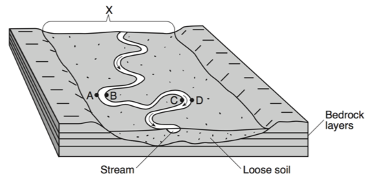
The landscape feature labeled X is best described as

a)

a flood plain

b)

a sand bar

c)

a delta

d)

an escarpment

38.

When two meanders meet, and the river is redirected, the resulting formation is called

a)

an oxbow lake

b)

a drumlin

c)

a delta

d)

an outwash plain

39.

Compared to land surface temperature changes, water surface temperatures changes occur

a)

More slowly because water has a lower specific heat

b)

More slowly because water has a higher specific heat

c)

Faster because water has a lower specific heat

d)

Faster because water has a higher specific heat

40.

In which atmospheric temperature zone does most precipitation occur?

a)

Troposphere

b)

Thermosphere

c)

Stratosphere

d)

Mesosphere

41.

Which is NOT an example of chemical weathering?

a)

The oxidation of a nail left outside for an extended about of time

b)

A tombstone that has had the letters washed away by acid rain

c)

The enlarging of a pothole from cycles of freezing and thawing

d)

An underground cave created from carbonic acid

42.
Why is the Equator warmest?
a)
Because it is closest to the sun.
b)
Because it receives the most direct sunlight
c)
Because no clouds form here.
d)
Because it is far from the sun
43.
The diagram below shows a section of a meander in a stream. The arrow shows the direction of stream flow. The stream bank on the outside of this meander is steeper than than the stream bank on the inside of this meander because the water on the outside of the meander is moving
a)
Slower, causing deposition
b)
Faster, causing deposition
c)
Slower, causing erosion
d)
Faster, causing erosion
44.
These are the first waves released during an earthquake
a)
S waves
b)
Surface Waves
c)
P waves
45.
These are the secondary, or second waves to be released. They cannot travel through the liquid outer core
a)
S waves
b)
Surface Waves
c)
P waves
46.
Which of the following is where one plate slides under another plate and old crust is recycled?
a)
submarine zone
b)
divergence zone
c)
subduction zone
d)
lower zone
47.

Which part of the ocean floor is represented by letter C?

a)

Continental Shelf

b)

Continental Slope

c)

Continental Rise

d)

Ocean Trench

48.

Which letter represents the mid-ocean ridge?

a)

B

b)

A

c)

F

d)

E

49.

The deeper you go in the ocean....

a)

Pressure increases and it gets colder and darker.

b)

pressure decreases and it gets colder and darker

c)

pressure increases and it gets warmer and brighter

d)

it gets wetter.

50.

Lyntreal went fishing last week and noticed that the tide went out while he was there. What caused this to happen?

a)

Gravitational pull from the Moon and Sun

b)

A rain storm

c)

Currents and waves

d)

Deep Ocean Trenches