
NEW
Font size
 Worksheets
Earth Science 5th grade
Total questions: 57
Worksheet time: 1hrs 12mins
Guess that Landform:
A river is flowing to the landform. There is a mix of water and land throughout the landform. It formed where the river meets the ocean. The area is flat.
Sand Dune
Delta
U Shaped Valley
Volcano
How is a V-Shaped Valley formed?
When ice from a glacier slowly melts over time
When the wind blows large amounts of soil toward the shore
When an earthquake breaks large rocks into small particles
When a fast-moving river carves steep sides into hills and mountains.

The force that caused this rock formation to crack was most likely created by —
ocean waves weathering the rock.
water freezing and thawing inside the rock.
a glacier passing over the rock.
wind creating a tunnel through the rock.
How does erostion shape the land?
Earth's surface is changed by living things.
Erosion does not change the shape of the land.
Erosion happens only in the winter.
Erosion carries the sediment and rock to another location, which changes the shape of the land.

What forms a delta?
sediments deposited in the ocean
sediments deposited in a lake
sediment deposited at the mouth of a river
sediment deposited at the base of a hill

Looking at this picture, we can see wind, water, and ice. These elements can move sediment during what process?
weathering
erosion
deposition
hurricane


A type of rock that forms in layers when sediments from a weathered rock were eroded and deposited in the ocean, where the compaction and cementation turned them into a new rock.
weathering
Sedimentary Rock
organic matter
sediments

the breaking down of rocks
erosion
deposition
sediments
weathering

small pieces of rock, soil, and other materials.
deposition
sediments
erosion
organism

carrying away of sediments
weathering
compaction
erosion
cementation

dropped off of sediments in new locations
compaction
deposition
cementation
erosion

Features on the surface of the Earth such as mountains, hills, canyons, and deltas.
Weathering
Erosion
Landforms
Construction

A deep gorge with steep sides that can be formed by moving water.
Canyon
Delta
Depostion
Glacier

Sand piles that are caused by wind erosion and deposition.
Volcano
Earthquake
Delta
Sand Dune

A large piece of ice and rock that breaks free and slides down a hill, picking up rock and sediments.
Earthquake
Glacier
Volcano
Delta

A wide area of low land between mountains created by a Glacier
V Shaped Valley
U Shaped Valley
Lowlands
Icelands

A narrow area of low land between hills and mountains created by a River.
Volcano
U Shaped Valley
V Shaped Valley
Riverbend


Which condition is necessary for dunes to be formed?
frequent rains and abundant plant life.
loose, sandy sediments and strong winds.
earthquakes and volcanic eruptions
strong ocean currents and large boulders.

Which of the following landforms is the result of a river carving out land by erosion?
mountain
sand dune
canyon
delta
Which forces create landforms such as deltas, dunes, and canyons?
volcanic eruptions
moving wind and water
planetary movements
earthquakes and landslides

A growing delta at the mouth of a river continues to grow because
the river deposits new material on the delta.
the river removes sediments from the delta.
the river moves farther away from the delta.
the river receives fresh water from the delta.

The Grand Canyon was caused by _____________________ erosion from the Colorado River.
water
wind
The movement of the tectonic plates is caused by
the rotation of the Earth.
convection currents in the Asthenosphere
the gravity of the iron-nickel core.
the Moho discontinuity.
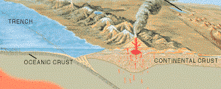
The 2004 Indian Ocean tsunami was caused by a shift in two plates that pushed one section of the sea floor under another section of the sea floor by 5 meters. What type of boundary is this?
divergent
convergent
transform
metamorphic

Where would sea floor spreading most likely occur?
At convergent boundaries (oceanic vs. oceanic)
At convergent boundaries (oceanic vs. continental)
At divergent plate boundaries (oceanic vs. oceanic)
At transform plate boundaries

What are the 4 main layers of the Earth?
Atmosphere, Hydrosphere, Biosphere, Athenosphere
Crust, Mantle, Outer Core, Inner Core
Rock, Magma, Ocean, Lithosphere
Top, Middle, Bottom, Crust

What is the thinnest layer of the Earth?
Crust
Mantle
Outer Core
Inner Core

What is the thickest layer of the Earth?
Crust
Mantle
Outer Core
Inner Core

Which layer of the Earth is a dense solid ball of Iron and Nickle?
Crust
Mantle
Outer Core
Inner Core

The soft part of the Mantle below the Lithosphere is called the:
Crust
Lithosphere
Asthenosphere
Core

The rigid rocky layer of the crust and upper mantle is called the:
Asthenosphere
Lithosphere
Core
Why did other scientists not believe in Wegener’s theory?
He could not explain how the continents moved
He didn’t have evidence
His data was wrong
He didn’t use the right technology to gather data
At a convergent boundary, one plate slides underneath the other into the mantle
At a convergent boundary, one plate slides underneath the other into the core
At a divergent boundary one plate flies into space

When plates are moving towards each other, this is called:
Transform
Convergent
Divergent
Volcanic

When plates are moving away from each other.
Convergent
Volcanic
Divergent
Transform

When the plates are sliding along one another in opposite directions:
Transform
Volcanic
Convergent
Divergent

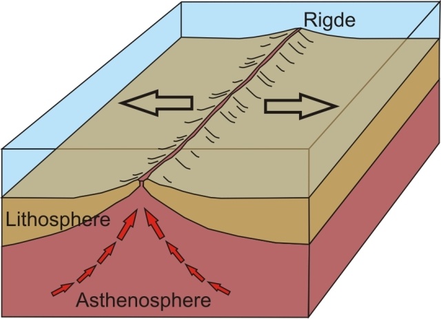
What kind of plate boundary is shown here?
divergent
convergent
transform
subducting
What geologic feature/event you be most likely to find at a transform boundary?
Earthquakes
Volcanoes
Mountains
Rift Valleys

What geologic feature/event would you most likely to find at a divergent boundary between two pieces of oceanic crust?
Rift Valley
Mid-Ocean Ridge
Island Arc
Flat land

Which of the following best describes how mountains change over time?
The elevation of the peaks will decrease due to erosion.
The elevation of the peaks will increase due to weathering.
The elevation of the peaks will increase due to deposition.
Mountains stay the same, they never change.

The diagram shows a landform on Earth. How did the movement of Earth’s plates form the landform?
Two oceanic plates slid past each other.
Two continental plates collided.
One continental plate slid past an oceanic plate.
One continental plate subducted beneath an oceanic plate.
The outermost, rigid layer of the earth, consisting of the earth's crust and upper part of the mantle is known as the ________________.
lithosphere
Pangaea
subduction zone
tectonic
Wegener
Upper part of the mantle
Crust and very top of the mantle

