wayground logo

Free Printable Worksheets

NEW

Font size

S
M
L
XL
Worksheets

PART ONE PHYSICAL GEOGRAPHY OF AFRICA TEST

Total questions: 67

Worksheet time: 1hrs 7mins

Name
Class
Date
1.

Which country makes up Africa's southernmost tip?

a)

Kenya

b)

Nigeria

c)

South Africa

2.

Which country touches Lake Victoria and borders Ethiopia and Somalia?

a)

Sudan

b)

Kenya

c)

Botswana

3.

In which country does the Niger River meet the Atlantic Ocean?

a)

Nigeria

b)

Mali

c)

Libya

4.

In which country does the Nile River meet the Mediterranean Sea?

a)

Cameroon

b)

Egypt

c)

Tanzania

5.

Which country is on Egypt's southern border?

a)

Sudan

b)

Algeria

c)

Angola

6.

What is the world's largest desert?

a)

Nigeria

b)

Rainforests

c)

Sahara

7.

True or False. The Sahel is between the Sahara and the savanna.

a)

True

b)

False

8.

A lush plant and animal habitat in Central Africa

a)

The Sahara

b)

savanna

c)

Tropical rainforest

9.

This desert is located in Southern Africa

a)

The Sahel

b)

Kalahari Desert

c)

Sahara Desert

10.

This river is the longest river in the world

a)

Congo River

b)

Mississippi River

c)

Nile River

11.

A mountain range along the coast of northern Africa

a)

Mt. Rushmore

b)

Atlas Mountains

c)

Mt. McKinley

12.

This is the largest lake in Africa

a)

Lake Victoria

b)

Lake Superior

c)

Lake Lanier

13.

True or False. Mt. Kilimanjaro tallest mountain in Africa

a)

True

b)

False

14.

True or False. The Great Rift Valley is created by tectonic plates.

a)

True

b)

False

15.

This is the principal river of central Africa

a)

Lake Victoria

b)

Congo River

c)

Niger River

16.
the absence of rainfall from an area of land
a)
arid
b)
drought
c)
harmattan
d)
desertification
17.
to artificially water crops
a)
harmattan
b)
tributary
c)
oasis
d)
irrigation
18.
a region where tall grasses grow
a)
savanna
b)
sahel
c)
sahara
d)
rain forest
19.
a fertile place in the desert where there is water and vegetation
a)
irrigation
b)
arable
c)
oasis
d)
tributary
20.
rich soil that is able to grow many plants
a)
cash crop
b)
tributary
c)
savanna
d)
fertile
21.
very dry
a)
arid
b)
fertile
c)
savanna
d)
harmattan
22.
in short supply
a)
arid
b)
sahel
c)
cash crop
d)
scarcity
23.
a narrow strip of semi-arid land south of the Sahara in Africa
a)
Sahara
b)
Sahel
c)
Savanna
d)
Rain Forest
24.
a strong, dry wind that blows in winter, carrying clouds of sand and dust
a)
cash crop
b)
drought
c)
nomad
d)
harmattan
25.
a change from productive land to desert
a)
deforestation
b)
desertification
c)
harmattan
d)
oasis
26.
removal of trees from an area of land
a)
desertification
b)
deforestation
c)
harmattan
d)
oasis
27.
dense evergreen forest with an annual rainfall of at least 160 inches
a)
Sahara
b)
Savanna
c)
Sahel
d)
Rain Forest
28.
a person who moves from place to place to make a living
a)
camel
b)
nomad
c)
resident
d)
settler
29.
a small stream or river that flows into a larger river
a)
tributary
b)
oasis
c)
sea
d)
bank
30.
land suitable for growing crops
a)
nomad
b)
arable
c)
cash crop
d)
drought
31.
crop grown to be sold on the world market
a)
harmattan
b)
nomad
c)
cash crop
d)
harmattan
32.

In size Africa is the ___ largest

a)

1st

b)

2nd

c)

3rd

d)

4th

33.

What part of Africa is covered in Rainforest?

a)

Center

b)

Northern

c)

Southern

d)

Coastal

34.

What part of Africa is Desert

a)

Northern

b)

Central

c)

Southern

d)

Both A and C

35.

Where is the Great Rift Valley Located?

a)

North

b)

South

c)

East

d)

West

36.

Sahara Desert is________

a)

Largest Desert in the World

b)

Bigger than the Continental US

c)

Has extreme temperature changes

d)

All of the above

37.

What is the Sahel?

a)

Hot desert

b)

Tropical Grasslands between Desert and tropical forests

c)

Region of Northern Africa

d)

Another name for coastal region

38.

Largest Lake of Africa

a)

Victoria

b)

Angel

c)

Nile

d)

Congo

39.

Tallest Mountain in Africa

a)

Nile

b)

Congo

c)

Kilimanjaro

d)

Serengeti

40.

Which body of water is indicated by the red star?

a)

Congo River

b)

Niger River

c)

Nile River

d)

Euphrates River

41.

Which body of water is indicated by the red star?

a)

Nile River

b)

Tigris River

c)

Congo River

d)

Niger River

42.

Which physical feature is indicated by the red star?

a)

Sahel

b)

savanna

c)

tropical rainforest

d)

Kalahari Desert

43.

Which physical feature is indicated by the red star?

a)

Sahara Desert

b)

tropical rainforest

c)

savanna

d)

Mt. Kilimanjaro

44.
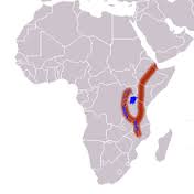
What geographic feature is highlighted? It is a ridge & plate boundary with lots of volcanic activity beneath its surface. Millions of years from now, it will split the continent in half.
a)
Sahel
b)
Transition Zone
c)
Ring of Fire
d)
Great Rift Valley
45.

Which body of water is indicated by the red star?

a)

Red Sea

b)

Nile River

c)

Congo River

d)

Lake Victoria

46.

Largest Lake on top

a)

Tanganikya

b)

Malawi

c)

Victoria

d)

Serengeti

47.

Middle Lake

a)

Tankanikya

b)

Malawi

c)

Victoria

d)

Serengeti

48.
Most of the land of Africa South of the Sahara consists of 
a)
Rich, rolling plains
b)
High plateaus
c)
Rugged mountains
d)
Dry, flat desert
49.
Which physical feature is located in East Africa? 
a)
Great Rift Valley 
b)
Congo Basin
c)
Cape of Good Hope 
d)
Sahara 
50.
The Great Rift Valley was formed mainly by 
a)
Shifting tectonic plates 
b)
Seawater erosion
c)
Nile River flooding
d)
Large meteor 
51.
What creates waterfalls on many African rivers?
a)
Volcanoes
b)
Earthquakes
c)
Escarpments
d)
Terminal moraines 
52.
The principal export in many Atlantic coastal countries is 
a)
Cacao
b)
Bananas
c)
Oil
d)
Chromium
53.
Which precious resource or resources is found in South Africa 
a)
Gold 
b)
Iron
c)
Diamonds 
d)
Both gold and diamonds
54.
Why are many Africa countries promoting ecotourism? 
a)
To allow tourists to distribute African plants
b)
To attract more industry and investments
c)
To encourage trade with other nations
d)
To help preserve the rain forest and boost economies
55.
In steppe areas, clearing trees or herding large amounts of livestock can cause 
a)
Farmers to become angry
b)
Desertification
c)
Irrigation problems 
d)
Soil to become compacted 
56.
Where do most parrots, monkeys, and snakes live in Africa? 
a)
On the rainforest floor
b)
In the steppes
c)
In the rainforest canopy
d)
In the tropical savanna 
57.
Where in Africa are you most likely to find elephants, lions, and giraffes? 
a)
In the steppes
b)
In the mountains
c)
In the rain forest
d)
In the savanna 
58.
The Namib and the Kalahari are two of Africa's 
a)
Deserts 
b)
Rainforests
c)
Highest mountains
d)
Savanna 
59.
A period of time when no rain falls
a)
Drought
b)
Desertification
c)
Lowland
d)
Succulent 
60.
Widespread clearing of land
a)
Desertification
b)
Deforestation
c)
Basin
d)
Drought
61.
A plant with thick, fleshy leaves that can conserve moisture 
a)
Basin
b)
Canopy
c)
Lowland
d)
Succulent
62.
Used to make drills and grinding tools 
a)
Sapphires 
b)
Diamonds
c)
Industrial diamonds
d)
Succulent
63.
Process that turns fertile land into land that is too dry to support life is called 
a)
Deforestation
b)
Desertification
c)
Drought 
d)
Canopy
64.
An umbrella-like covering formed by the tops of high trees 
a)
Canopy
b)
Rain forest
c)
Succulent
d)
Lowland
65.
This region is located along the coastline of the Atlantic and the Indian Ocean 
a)
Basin
b)
Lowland
c)
Steppe 
d)
Savanna 
66.
Tectonic plates cause low sunken areas to form a _________ when they lift up the land.
a)
Rift Valley
b)
Drought
c)
Basin
d)
Lowland
67.
Fast moving rivers in the region supply 
a)
Hydroelectric power
b)
Deforestation
c)
Desertification
d)
Lowlands