
 Worksheets
Meteorology Part 2 Test Prep
Total questions: 83
Worksheet time: 7hrs 55mins

Clouds most likely form as a result of
moist rising air, compressing and warming
moist rising air, expanding and cooling
dry rising air, compressing and warming
dry rising, expanding and cooling

Various weather conditions at LAX Airport in Los Angeles are shown on the station model below.
What were the barometric pressure and weather conditions at the airport at the time of the observation?
A)
914.6 mb of pressure and smog
B)
914.6 mb of pressure and a clear sky
C)
1014.6 mb of pressure and smog
D)
1014.6 mb of pressure and a clear sky

Base your answer on the weather map below and on your knowledge of Earth Science. The map shows a low-pressure system with two fronts extending from its center (L). Points A, B, C, and D represents locations on Earth's surface. Two different air masses are labeled. Which locations are most likely experiencing precipitation?
A)
A and B
C)
B and C
C)
C and D
D)
D and B
Which cross section best represents a cold front?


What type of front extends eastward from the low pressure center?
Warm front
Cold front
Occluded front
Stationary front

Which weather condition is shown along the cold front?
fog
snow
haze
thunderstorms

What was the most likely source region for the air mass over Pennsylvania?
New York State
Gulf of Mexico
Pacific Ocean
Canada
The properties of an airmass depend mainly on the
wind speed within the airmass
characteristics of the surface over which the airmass was formed
size of the airmass
rotation of the Earth
Which area is the most common source region for cold, dry air masses that move over New York State?
North Atlantic Ocean
Gulf of Mexico
central Canada
central Mexico

Base your answer on the weather map , which shows a low-pressure system over the eastern United States. Letters A through D represent weather stations.
Which station model correctly represents the barometric pressure at station A?


The weather station model shows some of the weather data for a certain location.
What is the wind speed shown on the station model and which instrument is used to measure the wind speed?
15 knots, measured by a wind vane
15 knots, measured by an anemometer
25 knots, measured by a wind vane
25 knots, measured by an anemometer


What is the wind direction for Albany?
NE
NW
SE
SW
What is the present weather for Albany?
Drizzle
Rain showers
Rain
Snow
Why are beaches that are located on the southern shore off Long Island often considerably cooler than nearby inland locations on hot summer afternoons?
Aland breeze develops due to the lower specific heat of water and the higher specific heat of land.
A sea breeze develops due to the higher specific heat of water and the lower specific heat of land.
The beaches are closer to the Equator than the inland locations are.
The beaches are farther from the Equator than the inland locations are.
Wind moves from regions of
high temperature toward regions if low temperature
high humidity toward regions of low humidity
high precipitation toward regions of low precipitation
high pressure toward regions of low pressure

At which weather station is precipitation most likely occurring at the present time?
A
B
D
E

If the low-pressure center follows a normal storm track, it will move toward the
Southeast
Southwest
Northeast
Northwest

The table below shows the air temperature and dewpoint at each of four locations, A, B, C, and D. Based on these measurements, which location has the greatest chance of precipitation? ESRT p. 12 may help.
A
B
C
D

Identify the type of front shown on the map. Use ESRT p 13
Warm Front
Cold Front
Occluded Front
Stationary Front

What is the actual temperature shown by the weather station model at Atlanta, Georgia
232 F
48 F
58 F
58 C

What is the actual pressure shown by the weather station model at Atlanta, Georgia
232 inches
232mb
923.2mb
1023.3mb

What is the actual wind speed shown by the weather station model at Atlanta, Georgia
2 knots
3 knots
15 knots
20 knots
Which sequence of events affecting moist air within Earth’s atmosphere causes cloud formation?
rising → expanding → cooling → condensation
rising → contracting → warming → evaporation
sinking → expanding → warming → condensation
sinking → contracting → cooling → evaporation

What are the dewpoint and wind direction shown on the station model below?
72°F and wind from the northeast
72°F and wind from the southeast
74°F and wind from the northwest
74°F and wind from the southwest

What is the actual barometric pressure at this location?
900.2 mb
10000.2 mb
1000.2 mb
902 mb

Which station model shows a wind direction from the northwest?
1
2
3
4

Which location has the greatest chance of precipitation?
Chicago
Detroir
Buffalo
Utica

Convert the air pressure in Buffalo NY to the actual air pressure.
028 mb
102.8 mb
1002.8 mb
10002.8 mb
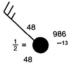
What is the wind direction for the following station model?
north
east
northwest
northeast
Which symbol would be used to identify an air mass originating in central Canada?
cP
mT
cT
mP
An air mass from the Gulf of Mexico, moving north into New York State, has a high relative humidity. What other characteristics will it probably have?
cool temperatures and high pressure
cool temperatures and low pressure
warm temperatures and high pressure
warm temperatures and low pressure
The Coriolis effect causes ___________.
the Earth to rotate on its axis
earthquakes
global winds to move in a curved path instead of a straight line
the Earth to revolve around the sun

Lines on a map that connect places of equal air pressure are called
Isotherms
Isobars
Isotemps
Isocream

Air moves from areas of _____ pressure to areas of ____ pressure.
high, low
low, high

Cold air is _______ dense than warm air.
more
less
the same as

Warm air is _____ dense than cold air.
more
less
the same as

Winds move in a curved pattern called
Tradewinds
The doldrums
The Coriolis Effect
Easterlies

The flow of air from an ocean or lake to the land is called a
Sea breeze
Land Breeze

The flow of air from land to a body of water is called a
Sea Breeze
Land Breeze

Sea breezes occur during
the day
the nigh

During the day, the _______ has an area of low pressure, and the ______ has an area of high pressure.
land, water
water, land

Which absorbs heat the fastest?
Land
Water

During the night, the _______ has an area of low pressure, and the ______ has an area of high pressure.
land, water
water, land

Air masses are names by these 2 factors:
temperature
density
moisture
speed

Continental air masses are located above
land
water

Maritime air masses are located above
land
water

Polar air masses are
hot
cold
medium temperature
Tropical air masses are
hot
cold
medium tempertaure

Weather events (clouds, rain, storms) occur along the edges of air masses at boundaries called
Coriolis effect
fronts
sea breezes
jet streams
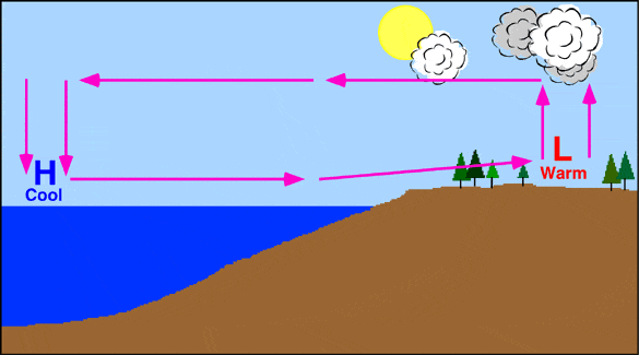
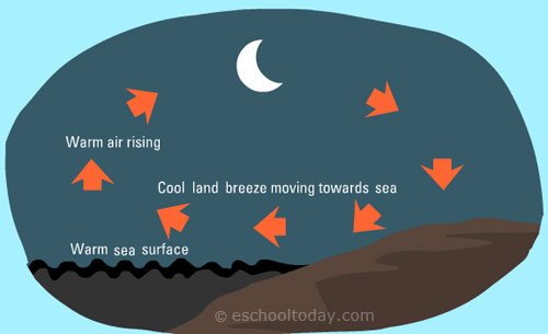


What is the main cause of winds?
amount of trees
the moon's gravity
amount of animals
uneven heating of Earth's surface

Land breeze and sea breezes are caused by the different _________ between land and water surfaces.
rotations
temperatures
gases
solids

The Coriolis Effect influences wind direction around the world due to the ______ of Earth cause the winds to curve.
tilt
shift
height
rotation


Cold fronts bring _____ temperatures and ______ conditions.
warm; fair
cool; fair
warm; stormy
cool; stormy

A warm front usually brings what type of weather conditions?
cold temperatures with stormy conditions
warmer temperatures with a slight chance of precipitation
cooler weather all day
warmer temperatures with strong storms


How can people stay safe during a tornado?
Drop, cover, and hold on.
Get in your car and drive to the nearest school.
Go outside and stand under a tree.
Go into a basement or sturdy building away from windows and cover yourself with a blanket or mattress.

How can people stay safe during a Hurricane?
Evacuate.
Get to higher ground in a sturdy building.
Board up any windows to decrease flooding.
Keep food and water in case of being stranded for multiple days.

In the U.S., a "typical storm track" moves storms the from SW to
SE
NE
SW
NW

