
 Worksheets
Weather Review 2 (Tests 2 and 3)
Total questions: 89
Worksheet time: 1hrs 2mins


Which statement explains what happens to solar energy that is absorbed at Earth's surface?
It heats the land and the water.
It heats the center of the Earth
It cools the water and heats the land.
It cools the lang and heats the water
Identify which is true about the solar energy that is able to reach Earth's surface.
It is reflected off the oceans before it is absorbed.
It is reflected off the Earth's surface before it is absorbed.
It is turned into heat more quickly by land than by oceans.
It is turned to heat more quickly by the oceans than by land.
The __________ is the source of all energy in Earth's atmosphere.
carbon cycle
mood
water cycle
sun
You are walking on the beach and the bottoms of your feet get hot. Which type of heat transfer did you experience?
conduction
convection
radiation
transpiration

This cold air travels from west to east in the northern hemisphere. Last winter, it dipped far south to bring cold air and snow to many southern states. This is the
Westerly Winds
Polar Jet Stream
Trade Winds
Tropical Jet Stream

Warm air rises at the equator and cold air sinks at the poles creating
convection currents
the Coriolis Effect
trade winds
hurricanes

The Gulf Stream current shown here makes the waters of the Atlantic Ocean
warmer
cooler
more dense
less nutrient rich

The diagram shows the global wind pattern in the lower atmosphere. What is the main factor that determines the global wind pattern?
The directions of ocean currents
Uneven landforms on Earth's surface
Earth's yearly revolution around the Sun
Uneven heating of Earth's surface by the Sun
While at the beach, you recorded the temperatures on land and at sea. You discovered that at night the ocean air temperature was higher than the temperature over land. During the night, which direction will the wind MOST LIKELY blow?
The wind will blow toward the land
The wind does not blow
The wind will blow toward the ocean
There is no way of telling which way the wind will blow

During the day, the Sun heats the ocean and the ocean stores this energy. During the evening the land cools and the ocean transfers the energy back to the air. As a result you get a cool breeze. Which direction would the breeze blow in this illustration?
left to right
right to left
top to bottom
there would be no breeze
Usually, it is observed that climates in coastal regions are moderate as compared to climates more inland. Why is this so?
Regions along the coast receive rain throughout the year; regions inland do not.
A cool breeze constantly blows from the ocean across the land at all times of the year.
Conditions over the oceans change rapidly because water loses or gains heat faster than land.
Conditions over the oceans change slowly because water takes more time than land to gain or lose heat.
Warm air ________, and cold air _________.
rises, sinks
sinks, rises
circulates, rises
Which would be an example of heat transfer through radiation?
You sit on the leather seat of the school bus and it burns your legs.
You sit on the beach and feel the wind blowing from the water.
You feel the warmth of the sun on your skin after being outside.
You feel the air conditioning come on in the classroom and get cold.
The main way that heat is circulated through the atmosphere is by _________.
conduction
convection
radiation
transpiration
Which statement explains why the trade winds move air?
Trade winds move cold air from the poles toward the east.
Trade winds move warm air from the poles toward the west.
Trade winds move cold air from the tropical region.
Trade winds move warm air from the equator.
Which list correctly names the three convection areas and climate zones?
Polar, Temperate, Tropical
Polar, Continental, Tropical
Temperate, Tropical, Westerly
Temperate, California Current, Gulf Stream Current
When determining a region's climate, the two main variables considered are the average __________ and __________.
air temperature and the size of the region
precipitation and average air temperature
wind speed and the types of animals present
barometric pressure and the average precipitation
In which climate zone do temperatures range from warm or hot summers to cool or cold winters?
polar zone
tropical zone
temperate zone
tundra zone
The most important way that surface ocean currents affect climate is by ___________________.
absorbing moisture from the air
reflecting sunlight from the oceans back into space
changing the direction of all the global wind patterns
bringing cold water to warm areas and warm water to cold areas
Which wind belt moves hurricanes across the Atlantic Ocean from east to west?
doldrums
polar winds
trade winds
westerly winds
What type of air would you expect the Subtropical Jet Stream to move?
It brings us warm, moist air from the south.
It brings us cold, moist air from the south.
It brings us warm, moist air from the north.
It brings us cold, moist air from the north.
Which of the following factors does NOT affect an area's climate?
elevation
latitude
global winds
water cycle
The curving of Global Winds is caused by the __________.
Coriolis Effect
Sea Breeze
Land Breeze
Greenhouse Effect
What kind of weather could you expect in areas that the Polar Jet Stream effects?
The polar jet stream would move warm, moist air down from the north.
The polar jet stream would move warm, moist air up from the south.
The polar jet stream would move cold, dry air down from the north.
The polar jet stream would move cold, dry air up from the south.

Which heat transfer is created in this diagram?
conduction
transpiration
convection
radiation

Which best describes why winds at the beach change direction between day and night?
because the temperatures over land and over water change
because warm air over land sinks and stays in place over land
because cool air rises and is replaced by warm air from the ocean
because cool air sinks and stays in place over land

Which ocean current is represented in the diagram?
Gulf Stream Current
California Current
South Atlantic Current
North Pacific Drift
True or False?
Cold water is more dense than warm water.
True
False

Which best describes the Gulf Stream Current?
Cold currents carry cold water from the polar zones to the equator
Warm currents carry warm water from the tropics towards the poles
Warm currents carry cold water from the tropics towards the poles
Cold currents carry warm water from the polar zones to the equator
True of False?
Land and water heat and cool at the same rate.
True
False
True or False?
Land heats up faster than water.
True
False

The diagram represents which convection current?
Land Breeze
Sea Breeze
Gulf Stream Current
California Current

The region that extends from 30 degrees North to 60 degrees North latitude
Tropical
Temperate
Polar

Which convection region begins at the equator and extends to 30 degrees North latitude?
Tropical
Polar
Temperate

Which convection region begins at 60 degrees north and extends to 90 degrees north latitude?
Polar
Temperate
Tropical
Wind blowing is an example of which heat transfer?
Radiation
Conduction
Convection
Walking on hot sand is an example of which heat transfer?
Convection
Conduction
Radiation
The pavement gets hot during the day through which heat transfer?
Convection
Radiation
Conduction
The sun melts the snow through _____________?
Radiation
Convection
Conduction
When I sit on my hot leather seats in my car, it may burn my legs. This is an example of ______________.
Radiation
Conduction
Convection
Land and water absorb heat _______________.
at the same rate
differently
Land is dark, _____________, and has very little movement.
translucent
transparent
opaque
clear
Darker surfaces absorbs ________ heat energy than lighter surfaces.
more
less
__________ areas tend to have greater temperature extremes because it's only heated at the surface.
Water
Land

The red area on the map would represent which convection region?
Polar
Temperate
Tropical

The yellow area on the map represents which convection area?
Polar
Temperate
Tropical

The blue on the map represents which convection area?
Polar
Temperate
Tropical

Which best describes the type of weather associated with low air pressure?
clear and dry
sunny and cold
sunny with high winds
cloudy with precipitation

Which most likely produces clear, cool weather?
zero air pressure
stable air pressure
a low pressure system
a high pressure system

Mark looks at the clouds in the sky and decides that he does not need to take his umbrella with him today. Which clouds did Mark most likely see in the sky?
cirrus
nimbostratus
cumulonimbus

Which best describes a storm that forms over warm sections of the ocean?
blizzard
hurricane
hailstorm
snowstorm

Which instrument is used to record average precipitation?
rain gauge
barometer
anemometer
weather vane

Which type of cloud is most responsible for severe thunderstorms?
cumulus
cirrus
stratus
cumulonimbus

Kaeric looks at the barometer and notices it’s dropping. What kind of weather should he expect?
cool and clear
rainy and stormy
foggy and cold
sunny and mild

Sometimes a cloud may form at or near the ground when the ground cools at night after a warm, humid day. This cloud is known as ___________.
altostratus
dew
fog
nimbostratus
In which situation would you use an anemometer?
You are measuring the amount of rainfall from the night before.
You are determining the direction from which the wind is blowing.
You want to know the amount of water vapor in the air.
You are finding the wind's speed for the afternoon.
Sometimes weather forecasters talk about cold fronts and warm fronts to describe how the weather is changing. A front is ________________.
the beginning of a storm that brings strong wind and heavy rain.
a boundary between air masses with different moisture content and temperatures.
an imaginary line that shows the location of different convection cells.
the location in which two clouds collide, causing lightning.
A student studies a weather map and notices that a warm, moist, low-pressure system is developing near his landlocked town. Which statement best explains why this system will not develop into a hurricane?
Hurricanes form over warm ocean waters, not landlocked areas.
Hurricanes form in cold, not warm, conditions.
Hurricanes take weeks to form.
Hurricanes require high-pressure systems to develop.
Which property of air does a barometer measure?
humidity
pressure
speed
temperature

This weather map predicts that a low-pressure system and cold front will bring snow to Denver, Colorado.
Which air masses most likely collided to form this cold front?
A cooler, maritime-tropical air mass overtook a warmer, maritime-polar air mass.
A warmer, maritime-tropical air mass overtook a cooler, continental-polar air mass.
A cooler, maritime-polar air mass overtook a warmer, continental-tropical air mass.
A warmer, continental-tropical air mass overtook a cooler, continental-polar air mass.
The most important way that surface ocean currents affect climate is by ______________.
absorbing moisture from the air
reflecting sunlight from the oceans back into space
changing the direction of all the global wind patterns
bringing cold water to warm areas and warm water to cold areas
To predict weather, meteorologists use all of the following EXCEPT _______________.
radars
satellites
radiation
weather maps
Describe Continental Polar (cP) air masses. (choose all that apply)
Cold
Warm
Dry
Humid
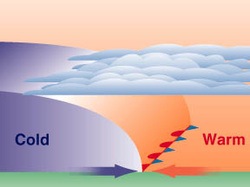
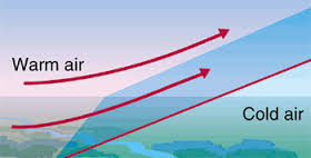
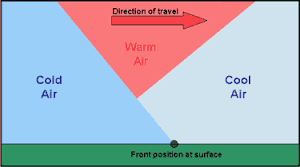
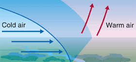

Take a look at the weather map. The front seen there causes short periods of storms, heavy rains, and thunderstorms. What type of front is this?
cold front
warm front
stationary front
occluded front
Air mass thunderstorms occur because of unequal heating of Earth's surface within one air mass. Where would an air mass thunderstorm MOST LIKELY occur?
over warm ocean waters
over large expanses of flat land
along coastal areas
in the area of continental air masses

According to the weather map seen here, we could expect weather conditions in El Paso to include
cold temperatures, sunny skies
cold temperatures, cloudy, and some precipitation
warm temperatures, sunny skies, and no rain
warm temperatures, increasing clouds, and showers

Which of the clouds shown would indicate a possible future rain storm?
A
B
C
D

What type of cloud is shown at point C?
cumulonimbus
cumulus
cirrus
altocumulus
How does a low pressure day compare to a high pressure day?
High pressure days signal fair weather and low pressure days signal stormy weather.
High pressure days signal stormy weather and low pressure days signal fair weather.
Low pressure days only occur during the summer months.
Low pressure days only occur during the coldest months of the winter.
An isobar marks where the _________ is the same.
temperature
humidity
air pressure
rain
Why do meteorologists use weather satellites to help make predications?
They can get information about the conditions throughout the troposphere.
They can get clear images of the clouds from above and track the movement of hurricanes.
They can get information about the intensity of the storm and the direction it is moving.
They can get information about the amount of rainfall the storm will carry.
All of the following are conditions for the development of a thunderstorm EXCEPT ________________________.
warm, humid air
cold, humid air
cumulonimbus cloud
large amounts of water evaporating
A tornado is best decribed as ____________________.
a low pressure system that develops over warm ocean waters.
a low pressure storm that develops only in the tropical region.
a rapidly whirling, funnel shaped cloud that reaches down from a cumulonimbus cloud to the ground.
a rapidly whirling, funnel shaped cloud that starts at the ground and reaches to the top of a cumulonimbus cloud.
Which tool measures humidity?
sling psychrometer
thermometer
rain gauge
anemometer



