
 Worksheets
MAP SKILLS REVISION
Total questions: 60
Worksheet time: 29mins
The four (4) features on a map
Title, direction, US Map, and Caribbean Map
Title, Key, scale, and direction
Key, scale, title, flags
Stars, key, direction, title
The four (4) features on a map
Title, direction, US Map, and Caribbean Map
Title, Key, scale, and direction
Key, scale, title, flags
Stars, key, direction, title
Which is a model of the earth?
Hemisphere
Basketball
Globe
Geography
The line which seperates the globe into the Northern and Southern Hemisphere is called
The Greenwich Meridian
The Equator
The Tropic of Cancer
The Arctic Circle
A compass rose is placed on a map in order to show
Elevation
Scale
Direction
Climate
What do we call the largest areas of land?
Islands
Peninsulas
Countries
Continents
The Prime or Greenwich Meridian are
Seperates the globe into the northern and southern hemisphere
Seperates the globe into the eastern and western hemisphere
Runs parallel to the equator
Is a line of longitude
Which of these is a continent?
Alaska
The Arctic
South Africa
Asia

What is the 4-figure Grid Reference (GR) for the caravan?
1632
1631
3116
1531

What is the 4-figure GR for the letter B?
1531
1432
1530
1431


What is the 4-figure GR for the letter D?
3117
173317
1731
1832


Define what is meant by Contour Lines
Lines on a maps
Lines on maps that connect places with the same altitude or height above sea level.
Lines known as the contour intervals
The distance between contour lines is known as
Lines
Interval
Interval lines
Contours intervals

What is the height of the contour line at point C?
200m
250m
210m
200km

Mexico is _____ of Cuba.
north
south
east
west

Cuba is _____ of Panama.
north
south
east
west

Brazil is _____ of Peru.
north
south
east
west
Colombia is _____ of Peru.
north
south
east
west

Italy is _____ of Spain.
north
south
east
west

Algeria is _____ of Libya.
north
south
east
west

Identify the symbol
Cable car
Campsite
Electricity pylon
Picnic site

Identify the symbol
Dance School
Recreation/Leisure/Sports Centre
Steep Cliff
Bungee Jumping

Identify the symbol
Metro
Mountain
Museum
Mill

Identify the symbol
Cycle Trail
Bike Shop
Motorbike Race Track
Free Bicycle Parking

Identify the symbol
Telephone
Apple Store
Police Station
Information Centre

Identify the symbol
Pokemon
Petrol
Parking
Pizza Shop

Identify the symbol
Youth Hostel
Hotel
Pyramid
Bed and Breakfast

Identify the symbol
Coniferous Trees
Non-Coniferous Trees

What does this map symbol mean?
car park
airport
park
golf course

What does this symbol mean?
airport
viewpoint
nature reserve
hospital

What does this symbol mean?
power station
hospital
train station
Chinese restaurant
What does this map symbol mean?
car park
airport
park
golf course

What does this symbol mean?
carpark
stadium
bus station
police station

What does this symbol mean?
campsite
forest
park
toilet
What does a key on a map do?
Shows you how to fold the map
Shows you which way up to hold the map
Shows you what language the map is written in
Shows you what the symbols mean

What does this symbol mean?
park land
marsh land
heath land
sea shore
What does this symbol mean?
airport
viewpoint
nature reserve
hospital
What does this symbol mean?
power station
hospital
train station
Chinese restaurant
When the contour lines on a map are close together what does this show?
There is a steep slope
There is a lake
There are trees
There is a river
What does adding contours to a map show?
Where the hills are
How many trees there are
How long the river is
How hot the climate is

What does this symbol mean?
ice
rainbow
shallow water
viewpoint
What are the reference numbers that appear first in a grid reference?
Northings
Eastlings
Northlings
Eastings
The horizontal lines in a grid are known as...
Eastings
Northings

What point is located at 176322?
B
D
C
A

What is the interval of the above contour map?
10 meters
5 meters
1 meter
20 meters

Is the spot height shown on the contour map?
Yes
No
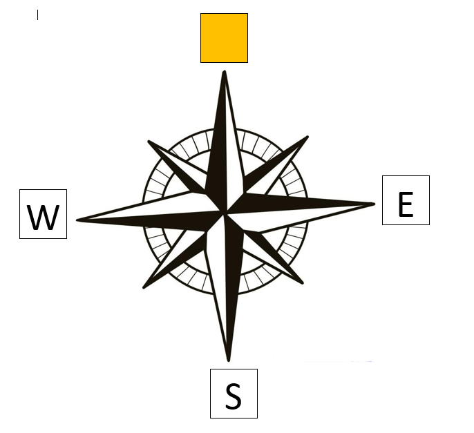
Which direction is missing?
North
East
Northwest
South
Northeast

Which direction is missing?
North
East
Southeast
South
Northeast

Which direction is missing?
North
Northwest
Southeast
Northeast
Southwest


Which direction do you need to go to get to the hospital from city hall?
northwest
southwest
northeast
southeast
Contour lines on a map show...
the key of the map
symbols
direction of a place
the height above sea level
1km = _______________ cm
10
100
1000
100 000
If a map has a scale of 1 cm: 50 miles and the distance on the map between Chicago and Cincinnati is 5 centimeters, which of the following is the actual distance between Chicago and Cincinnati?
5 centimeters
50 miles
250 miles
500 miles
A map of scale 1 : 10 000 means that 1 cm on the map represents the actual distance of 10 000 cm on the ground.
What does 4 cm on the map represent?
4 cm
400 cm
40 000 cm
40 000 m
What type of scale is shown?
5: 6 000 000 000
Representative Fraction Scale
Linear Scale
Word Scale

