
 Worksheets
Fossil & Layering
Total questions: 61
Worksheet time: 4hrs 43mins

Jimmy hears on the news that there had been a huge earthquake, but he didn't know the location of the earthquake. Based on the map below, what would be the most likely location for an earthquake?
California
Maryland
Germany
Nigeria
Brazil

Which of the following areas would be more likely to experience earthquakes?
An area that is closest to tectonic plate boundaries.
An area that can flood very easily.
A scientist is examining a core sample and studying rock layers. Which rock layers are older?
The layers on the bottom of the sample.
The layers on the top of the sample.
A scientist finds a fish fossil on the top of a mountain. What can the scientist infer from this evidence?
The top of the mountain was once under a body of water and the water has receded over time.
The fish once lived on the mountain before moving into the ocean.
The fish was placed there by somebody.
What is weathering?
The breakdown of rocks over time.
The movement of soil and rock over time.
Soil, rock, or sand moves from one place and settles in another. The process of dropping sand, soil, or rock in a new location is called...
What is erosion?
The breakdown of rocks over time
The movement of soil and rock over time
Soil, rock, or sand moves from one place and settles in another. The process of dropping sand, soil, or rock in a new location is called...
What is deposition?
The breakdown of rocks over time
The movement of soil and rock over time
Soil, rock, and sand moves from one place and settles in another. The process of dropping sand, soil or rock in a new location is called...
How does freezing water cause the weathering of rocks?
The freezing water keeps the rocks in place.
The freezing water expands the cracks and breaks rocks.
The freezing water makes the rocks last longer.
The freezing water causes rocks to fall in landslides.
Weathering and erosion are SLOW changes to the earth.
True
False

Based on this image, what can we say about the area where these fossils were found?
This area was underwater a long time ago.
Mammals are the oldest fossils.
Trilobites are the youngest fossils.
a scientist who studies fossils
geologic time
plate tectonics
Pangaea
paleontologist
the movement of weathered materials by water, wind or ice
glacier
erosion
soil
rock
the remains or traces of an organism that lived long ago
glacier
erosion
fossil
rock

The geologic map below shows several rock formations exposed when a road is cut through a hillside.
Which formation in this geological map is youngest?
1
2
3
4

Use this geologic profile to answer the following question.
Which of the following BEST describes the fossil at Point 3 when compared with the fossils at Points 1 and 2?
The fossil at Point 3 is less common
The fossil at Point 3 is smaller.
The fossil at Point 3 is older.
The fossil at Point 3 is more complex

When two fish die, Fish A sinks to the bottom of a lake and Fish B washes up on the rocky lake shore.
Why is a fossil more likely to form from the body of Fish A than from the body of Fish B?
Soft parts of the fish will decay more quickly in the water.
Sediments in the water will quickly cover the fish
Scavengers in the water will eat the remains of the fish.
Currents in the water will move the fish.
How do scientists know that some mountains were once at the bottom of an ocean?
Freshwater rivers flow to the ocean.
Saltwater fish are found in some mountain streams.
Dinosaur bones have been discovered in the mountains.
Marine fossils have been found on the peaks of some mountains.


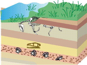
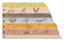

Which of the following rock layers contains the youngest fossils?
A
B
C
D
MOM, can we go PLEASE?” Ryan begged as he was looking at the museum booklet for the new fossil exhibit.
“We have tickets for 3:00 today. Why don’t you eat some lunch and get ready to go?” Mom said.
Ryan raced to the kitchen and gobbled down some dinosaur shaped chicken nuggets. Soon it was time to leave for the History Museum. He was so excited to see all of the dinosaurs and fossils that were millions of years old.
When Ryan entered the door of the museum it was as if he was stepping back in time…
1. Ryan had learned that Earth's surface has changed over time. What evidence has been collected by scientists to support this theory?
Ancient people left photographs of Earth's surface behind for scientists.
Fossils have been found that give clues to what Earth's surface looked like many years ago.
Paleontologists have studied Earth's surface in the past and present and see no changes
We do not know what Earth's surface looked like long ago

As Ryan and his mom walked through the museum the walls transformed into a model of the Grand Canyon. The layers were so many different shades of red and brown.
“This is AMAZING!” Ryan cried as he looked from the floor to the ceiling.
The story of the Grand Canyon is written in all of its beautiful rock layers. They were formed millions of years ago. Geologists study the layers to discover the history of the area.
Where are the oldest rocks of the Grand Canyon?
At the top of the mountain
Where the darker rocks are located
At the bottom of the mountain near the river
Where the lighter colored rocks are located
Fossil evidence provides scientists with information about...
how an environment has changed over time.
rocks and minerals.
where earthquakes occur.
how mountains form.

As Ryan began looking closely at the model layers of the Grand Canyon, he noticed what looked like animals in some of the rocks.
“MOM! LOOK! There are fossils in the rocks!” Ryan shouted.
“Shhhh, not so loud. Let’s see what we can learn about them,” mom whisperd.
Look at the picture of the fossils found in the layers Ryan saw.
Based on the evidence shown, what was the most likely environment of these organisms?
The environment was most likely covered in rock.
The environment was most likely cold and icy.
The environment was most likely underwater.
The environment was most likely dry and hot.
The gradual breaking of rocks into smaller pieces is called...
erosion
weathering
deposition

Where would you expect a volcano to be located?
in the middle of the continent
at the edge of the continent
near tectonic plate boundaries

Take a look at the fossil evidence in the picture. What type of environment may these fossils have come from?
Forest
Desert
Ocean
Locations of natural disasters like volcanoes and earthquakes can be described as...
forming in a pattern
forming randomly on Earth
Only found in the ocean
Only found in South America
Volcanoes are...
just as likely to happen in the middle of a continent as they are on the coast
more likely to happen on the coast of a continent
randomly popping up in all parts of the continents
never found in the ocean
You are designing a home that will be safe from a volcanic eruption. Which of the following would NOT be a sucess critera of your home?
a roof that is steep and angled so that ash will fall off
the home made out of a material that will not melt if touched by lava
the windows boarded to protect from heavy rainfall or winds
the entire project stays within your budget
Scientists have tools that monitor volcanic activity. However, there are too many volcanoes and not enough time or tools to monitor them all. What would be the best way to improve monitoring of volcanoes?
not monitor any volcanoes because it is too expensive
keep track of patterns of when volcanoes erupt, and only monitor the ones that may be close to erupting
monitor all the volcanoes, but don't interpret the data we get from the tools
because volcanic eruptions are not dangerous to people, we do not need to monitor them
Which of the following claims is NOT true?
Natural disasters can cause serious to damage to people and homes
Natural disasters are difficult to predict
Humans can lessen the impact of natural disasters if they are prepared
Natural disasters can be prevented

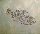

A rock layer contains petrified forest trees on the bottom layer. On the top layer we find ocean fish. What can we infer from this information given?
The bottom layer is the oldest
The ocean fish were there for a long time
People must have brought fish in the forest
The area was once a forest, but is now an ocean

The discovery of fossilized coral reefs on land is evidence that
salt water changes coral into fossils.
the reefs formed in a freshwater lake.
the sea level has changed over time.
coral reefs can form on dry land.
Thousands of fish fossils discovered high in the Rocky Mountains most likely indicate that
ancient sea levels were once high enough to cover the mountains.
a large flood washed the fish up to the tops of the mountains.
the mountains were once part of the sea floor that was pushed up by tectonic forces.
the fish were inhabitants of an ancient stream that became frozen during the ice ages.
Which statement below best explains why several fossils of sea organisms were discovered buried deep in an area of dry land?
The fossils changed locations.
The area had a shift in climate.
The land was once underwater.
A glacier once covered the area.
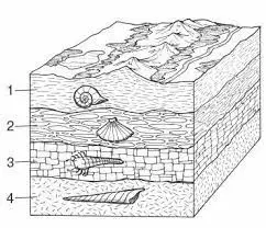
Which layer is most likely the youngest?
Layer 1
Layer 2
Layer 3
Layer 4
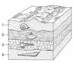
Which layer is most likely the oldest?
Layer 1
Layer 2
Layer 3
Layer 4
Which kind of events can form mountains?
earthquakes and volcanoes
earthquakes and landslides
landslides and avalanches
volcanoes and avalanches
Which would most likely need storm drains?
a highway with wide shoulders
a city street with concrete curbs
a gravel road that has many farms
a dirt road that runs through a forest
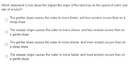
Statement a
Statement b
Statement c
Statement d

April and her family are planning a hike. They study a topographic map of the hike. Which of the following does this topographic map show that will best help them plan their hike?
location of rivers
how wide the trail is
steepness of the trail
where the best views are
What is the Ring of Fire?
an area of earthquakes along the edges of the Pacific Ocean
an area of mountain ranges below the Atlantic Ocean
an area of volcanoes along the edges of the Pacific Ocean
an area of tsunamis along the Indian Ocean

Based on this map, which of the following places has many earthquakes?
the land area making up Australia
the middle part of the Pacific Ocean
the western part of Africa
along a line in the center of the Atlantic Ocean

What do the lines on this map represent?
volcanoes
easrthquakes
plate boundaries
travel routes

Volcanoes and earthquakes tend to occur near what?
mountains
islands
plate boundaries
fault lines


Is there a pattern to the locations of earthquakes and volcanoes around the globe?
No, earthquakes and volcanoes are random.
Yes, earthquakes and volcanoes usually occur near the boundaries of tectonic plates.
yes, earthquakes and volcanoes usually occur in the middle of tectonic plates.
No, earthquakes and volcanoes usually occur under water.

