
 Worksheets
Oceans (Chapter 13-15)
Total questions: 72
Worksheet time: 50mins
The deflection of wind and water currents due to the rotation of the Earth is called...
The Coriolis Effect
The Cornea Effect
The Corona Virus
The Toyota Corolla
Equatorial Deflection
what are the two factors that influence the density of the water in thermohaline circulation?
Depth
Temperature
Salinity
Pressure
Wind
In the northern hemisphere, gyres rotate ____________, while in the southern hemisphere, gyres rotate ____________.
Clockwise; Counterclockwise
Counterclockwise; Clockwise
South; North
North; South
Similar to the greenhouse effect, the ocean...
Traps thermal energy from the sun.
Is a big cause of global warming.
Provides nutrients to all the plants of Earth.
Protects us from harmful radiation.
To help regulate Earth's temperature, warm water tends to travel towards the __________, while cool water travels towards the __________.
North and South Poles; The equator
North; South
East; West
The equator; North and South Poles

This Image represents...
Downwelling
Upwelling
Thermohaline circulation
Rip Current
Which of the following has the greatest influence on the Tides?
The speed the Earth is rotating
The moon's gravity
The Sun's gravity
The time of the year
A spring tide is known for having very ___________ tides.
Extreme
High
Moderate
Low
A neap tide is known for having very ___________ tides.
Extreme
High
Moderate
Low

______ causes surface currents.
The Coriolis Effect
gravity
density differences
wind
The __________ is a surface current that flows along the eastern US and brings warm water to Europe.
California Current
Gulf Current
North American Gyre
Arctic Current
As plants and animals in the ocean die, the nutrients produced from their decay _____.
are recycled by the Global Conveyor Belt
sink to the bottom
are destroyed by sunlight
become coral reefs
Nutrients are brought to the surface for phytoplankton to use at _______.
gyres
eddies
upwellings
the equator
_______ are the producers of Antarctic food webs.
Zooplankton
Phytoplankton
Whales
Upwellings
The sun's rays are more direct at the...
poles
equator
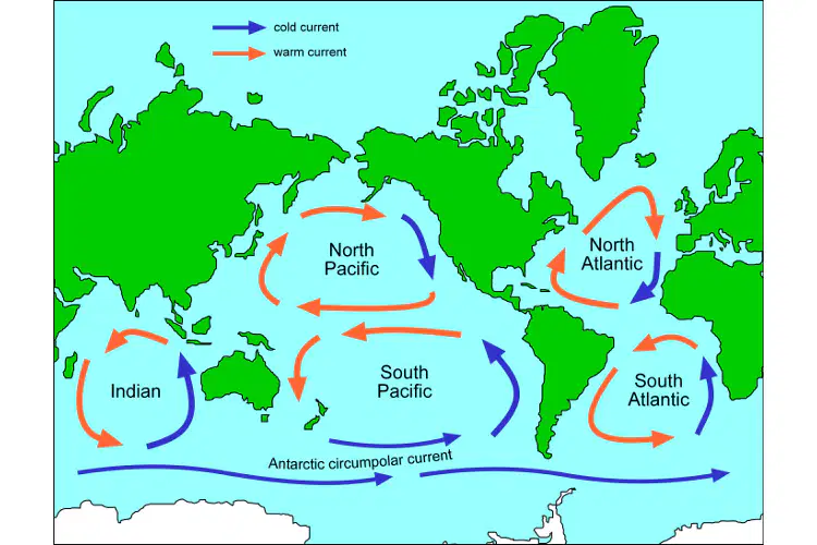
There are _______ major gyres in the world.
6
3
4
5
The large, circular surface-current pattern found in each ocean produced by wind and the Coriolis effect
California Current
Upwelling
Gyre
Global Conveyor Belt
The most common type of marine debris is
metal
glass
plastics
paper
cloth

MOST sealife lives in the:
Photic zone
Twilight zone
Midnight zone
Deep zone

In the ocean, this abiotic factor increases substantially with depth.
Temperature
Pressure
pH
Sunlight

A reef running parallel to the shore but separated from it by a channel of deep water.
fringing reef
barrier reef
atoll
archipelago
Which type of fishing has high rates of bycatch and highly destructive of benthic communities.
Pole Fishing
Long Line Fishing
Purse Seining
Trawling
Bycatch is one of the largest threats to maintaining a healthy marine ecosystem. What is bycatch?
Bycatch is an intentional catch
Bycatch is an accidental and unwanted catch
The main difference between photosynthesis and chemosynthesis is:
Photosynthesis gives off carbon doxide, while chemosynthesis gives off oxygen
photosynthesis happens in the dark, while chemosynthesis happens in light
photosynthesis uses chemicals (hydrogen sulfide) to make food, while chemosynthesis uses light
chemosynthesis uses chemicals (hydrogen sulfide) to make food, while photosynthesis uses sunlight
Which species is most affected by bycatch?
Salmon
Krill
Sharks
Star Fish
____________ is what you call an area with ONE HIGH and ONE LOW tide each day.
Diurnal Tide
Semi Diurnal Tide
Mixed Tide
Rip Tide
____________ is what you call an area with TWO HIGH and TWO LOW tides each day.
Diurnal Tide
Semi Diurnal Tide
Mixed Tide
Rip Tide
____________ is what you call an area with TWO HIGH and TWO LOW tides each day, but they are NOT the same size.
Diurnal Tide
Semi Diurnal Tide
Mixed Tide
Rip Tide
____________ is what you call when a tide spills over a sandbar, creating a DANGEROUS CURRENT.
Diurnal Tide
Semi Diurnal Tide
Mixed Tide
Rip Tide
Which tide results in the LARGEST movement of water?
Spring Tide
Neap Tide
Rip TIde
Ebb Tide
Which of the following has the GREATEST gravitational effect on the tides?
Earth
Moon
Sun

Which of the following is NOT a reindeer on Santa's Sleigh?
Comet
Dasher
Vixen
Dixon

Which type of tide occurs on the side of the Earth closest to the moon?
High Tide
Low Tide
The gulf stream current is...
warm
cold

what daily tide pattern?
mixed
semidiurnal
diurnal
spring
Equatorial currents will always be...
warm
cold
What is upwelling?
A process in which warm water rises toward the surface
A process in which deep, cold water rises toward the surface
A process in which surface water sinks to the ocean floor
A process in which ocean currents change direction
Which ocean current is a well-known regional link in the ocean conveyor belt?
The Gulf Stream
The North Atlantic Drift
The California Current
The Kuroshio Current
What is El Niño-Southern Oscillation (ENSO)?
A periodic warming of surface waters in the tropical eastern Pacific Ocean
A process in which deep, cold water rises toward the surface
A phenomenon that affects ocean and atmospheric circulation patterns
A type of ocean current
What happens during El Niño?
Trade winds weaken and warm water expands towards South America
Trade winds strengthen and cool water expands towards South America
Ocean currents speed up and nutrient availability increases
Surface water temperatures in the eastern Pacific Ocean become unusually cool
What is the effect of El Niño on coastal upwelling?
Coastal upwelling strengthens, leading to increased fish populations
Coastal upwelling weakens, leading to reduced fish populations
Coastal upwelling remains unaffected by El Niño
Coastal upwelling stops completely during El Niño
What is La Niña?
A phenomenon that occurs after El Niño
A type of ocean current
A process in which deep, cold water rises toward the surface
A periodic cooling of surface waters in the tropical eastern Pacific Ocean
Which marine environment is the transition between land and ocean?
Intertidal zone
Benthic environment
Pelagic environment
Neritic zone
What is the benthic environment?
The ocean floor from the shoreline to a depth of 200m
The part of the pelagic environment that overlies the ocean floor at depths greater than 200m
The area of shoreline between the low and high tides
The part of the pelagic environment that extends from the surface to a maximum depth of 150m
What are corals?
Soft-bodied animals that live in hard cups or shells of calcium carbonate
Flowering plants adapted to live in sea water
Large and complex seaweeds found in cooler temperate marine waters
Animals that burrow in the ocean floor
What is the largest marine environment?
Intertidal zone
Benthic environment
Neritic province
Oceanic province
What is the largest ocean on Earth?
Pacific Ocean
Atlantic Ocean
Indian Ocean
Arctic Ocean
Which of the following is the major constituent of seawater?
Calcium carbonate
Sodium chloride
Potassium nitrate
Magnesium sulfate
What is the process of growing aquatic organisms for human consumption called?
Aquaculture
Mariculture
Hydroponics
Horticulture
What is the term for unintended catch in commercial fishing?
Bycatch
Overfishing
Trawling
Dredging
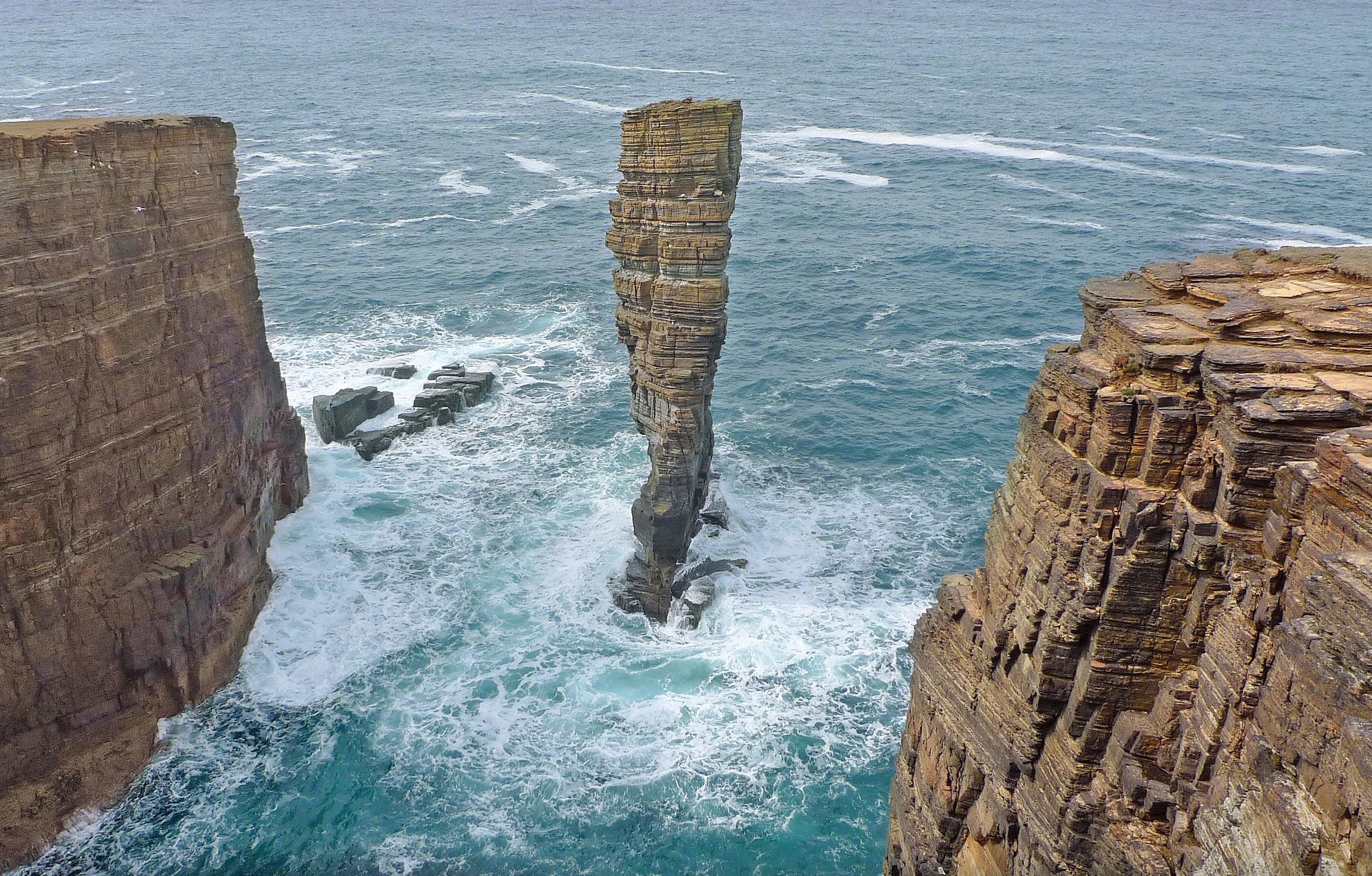
Identify the landform type.
Sea Stack
Sea Stump
Arch
Bay

A _______ is a long, narrow finger of sand or shingle jutting out into the sea from the land.
Beach
Sand dune
Spit
Bar
When waves activity brings sand onto the beach, it is...
Weathering
Erosion
Deposition
A shallow body of water separated from a larger body of water by barrier islands or reefs.
inlet
barrier island
lagoon
spit
A barrier built out into a body of water to protect a coast or harbor from the force of wind, waves, tides and currents
spit
groin
seawall
breakwater
A long, narrow structure (often times piles of large rocks) built out into the water, perpendicular, from a beach in order to prevent beach erosion or to trap and accumulate sand that would otherwise drift along the beach face.
breakwater
seawall
groin
spit
When waves reach shallow water, they are often bent and tend to become parallel to the shore. This process is termed ________.
oscillation
refraction
reflection
translation

