
Font size
 Worksheets
Earth Systems Practice
Total questions: 47
Worksheet time: 34mins
Florida is the most humid state in the nation. Which statements below best explains why this is true?
Cool ocean breezes hold a lot of water as humidity as they move inland.
Florida's coasts are either the warm Atlantic Ocean or Gulf of Mexico. Warm air above warm water holds a lot of moisture that moves inland.
Florida's coasts are either the warm Atlantic or Pacific Oceans. Warm air above warm water holds a lot of moisture that moves inland.
It rains in Florida every day of the year so the air is always saturated with water.
The trade winds are regular, global wind patterns that were used by ships to sail across the Atlantic and Pacific Oceans. Trade winds are created by
ocean water evaporation during El Niño years.
large weather systems like hurricanes or typhoons.
warm water ocean currents caused by the rotation of the Earth.
convection currents caused by the uneven heating of Earth.
The main reason the North and South poles have cold winds is because ____________.
How do convection currents distribute heat within the oceans?
cold water rises and warm water sinks
warm water is more dense than cold water
cold water jet streams move along the surface and warm water jet streams move below the surface
warm water rises and cold water sinks
Convection currents allow heat to be distributed ____________.
The oceans MOST influence global climate by
releasing heat to the atmosphere.
cooling bordering land masses.
providing continuous onshore winds.
removing water vapor from the atmosphere.
The water cycle recycles water on Earth. Which of these is the source of MOST of the water vapor in Earth's atmosphere?
rivers flooding
glaciers melting
oceans evaporating
plants transpiring
What is the main source of energy that drives all weather patterns?
the Sun
oceans
the Moon
mountains
Which statement BEST describes the effect of the Sun on the oceans?
The Sun influences the formation of waves.
The Sun creates water particles.
The Sun's rays cause organisms to come to the surface.
The Sun provides minerals.
Hurricanes are large, powerful storms that form as they travel over warm ocean waters. What do oceans add to make hurricanes so strong?
salt and water
wind and tides
heat and moisture
waves and flooding
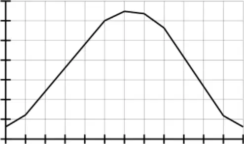
The monthly average temperature pattern of Jacksonville, Florida, is shown below. Which statement best describes the influence of an ocean current(s) on this climate?
The Gulf Stream carries cold water from the north southward near the Atlantic coast.
The Gulf Stream carries warm water from the tropics northward near the Atlantic Coast.
The jet stream consistently pushes warm air into the Jacksonville area.
Warm ocean currents from the Gulf of Mexico travel eastward to Jacksonville.
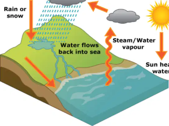
The diagram below shows that ocean water is warmed by the sun and then evaporates to form clouds. What effect does this cycle have on the climate along the coast?
Clouds are constant along the coast and the air is dry.
Wind and warm temperatures are constant along the coast and the air is dry.
Rain is common along the coast and the air is humid.
Snow is common along the coast and the air is humid.
The weather patterns of a place over a period of time determine its ________.
atmosphere
climate
temperature
water cycle
Below are lists about conditions in a city. X - 6 cm of rain this morning - 20°C at noon - low humidity tonight Y - annual snow fall is 1.2 meters - spring is cool and wet - summer is warm and dry What BEST describes X and Y?
X and Y both list statements about climate.
X and Y both list statements about weather.
X lists statements about weather. Y lists statements about climate.
X lists statements about climate. Y lists statements about weather.

Which table correctly shows weather and climate?
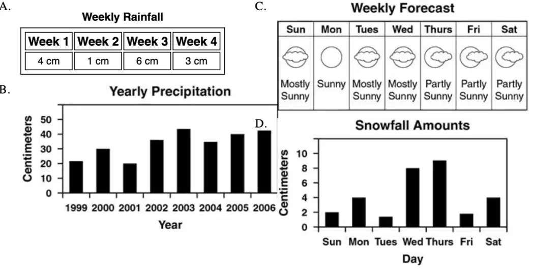
Which graphic shows climate data for an area?
Weekly Rainfall
Yearly Precipitation
Weekly Forecast
Snowfall Amounts
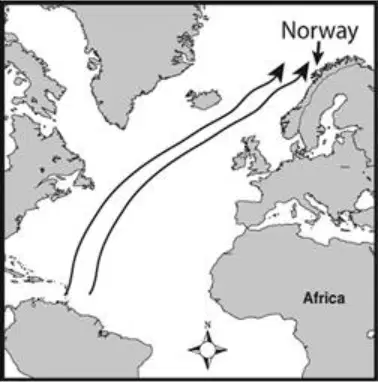
Look at the diagram to answer the question that follows. If a northern coastline such as the Norway coast is located near a warm ocean current, the climate will be colder than normal for that latitude, the climate will be warmer than normal for that latitude, spring is longer than normal for that latitude, or spring is shorter than normal for that latitude?
the climate will be colder than normal for that latitude.
the climate will be warmer than normal for that latitude.
spring is longer than normal for that latitude.
spring is shorter than normal for that latitude.
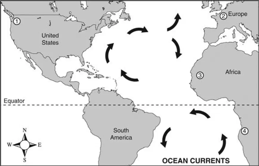
Examine the map of ocean currents. Ocean currents affect climates around the world. Based on the map, which area MOST likely has a warmer climate than expected?
1
2
3
4
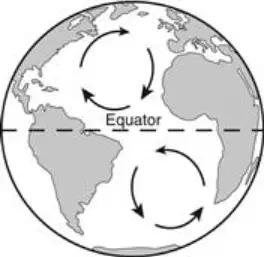
The picture illustrates the rotation of ocean currents in the Northern and Southern Hemispheres. The rotation of currents in the Northern Hemisphere affects the
strength of hurricanes.
climates of landmasses.
number of storms that develop.
amount of wind in the lower latitudes.
When water in a pan is heated, the temperature of the water near the bottom of the pan increases. The warmer water becomes less dense, and rises through the cooler, more dense water near the top of the pan. In turn, the cooler water near the top of the pan sinks and moves toward the bottom of the pan and begins to warm. What is the effect of the circular motion of water in the pan?
Heat flows by conduction.
Heat flows by thermal radiation.
Heat flows by convection currents.
Heat flows by thermal expansion.
Which of the following will cause convection currents?
the Sun warming the atmosphere
ocean breezes near the coast
water vapor formation
high and low pressure systems
Convection currents are caused by the uneven heating of Earth. This uneven heating normally occurs when different amounts of heat are
released by volcanic eruptions.
released during El Niño and La Niña weather systems.
reflected during large storms generated by cyclones.
absorbed by the surface of the ocean, land, or air.
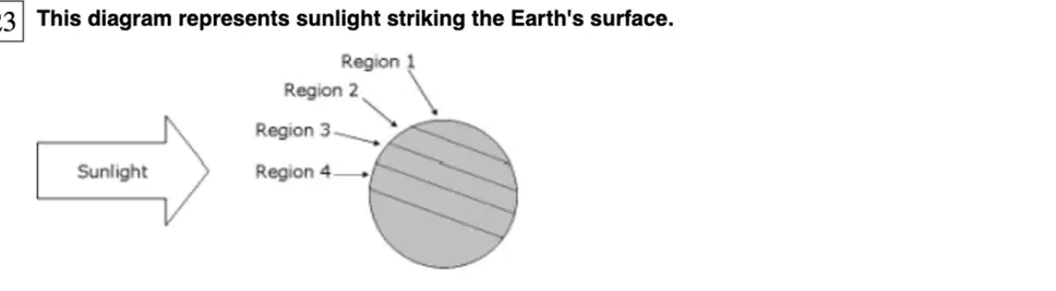
This diagram represents sunlight striking the Earth's surface. The greatest amount of rising air will occur in __________, causing convection currents.
Region 1
Region 2
Region 3
Region 4
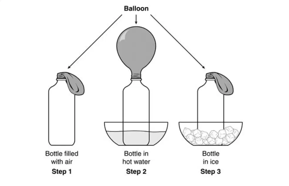
Uneven heating of Earth causes convection currents. What part of this process is being demonstrated in this diagram?
Heat causes gases to expand.
Heat causes gases to contract.
As air cools, currents flow clockwise.
As air cools, currents flow counterclockwise.
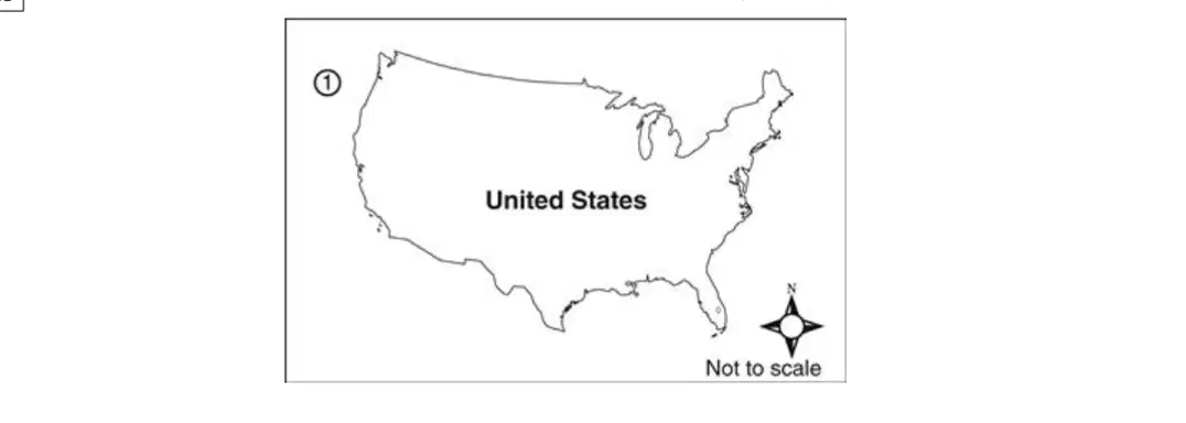
Air masses have the same properties as the surface over which they develop. If an air mass develops over Region 1, which properties will it MOST likely have?
hot and dry
cold and dry
hot and moist
cool and moist
What are the characteristics of maritime polar air masses?
cool and dry
warm and dry
cool and humid
warm and humid
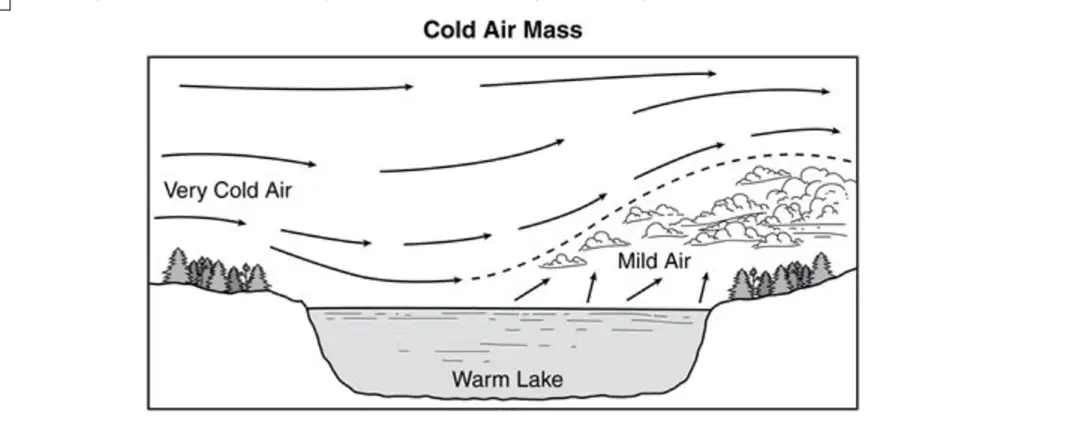
The diagram below shows a very cold air mass moving over a large, warm lake. When cold air in the winter passes over large bodies of warm water, moisture is picked up. As the air rises rapidly over land,
lightning generally occurs.
precipitation generally occurs.
cold fronts become warm fronts.
hurricanes are formed.
Which condition is associated with MOST warm fronts?
tornado formations
low temperatures
violent air mass collisions
cloud formations bringing precipitation
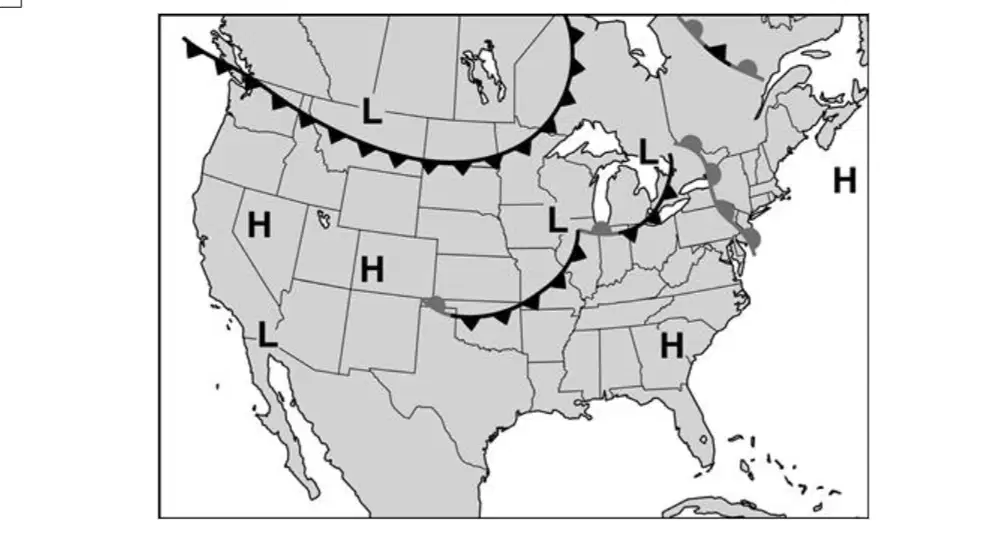
This weather map shows a variety of high- and low-pressure systems across the country. Which of the following is the MOST likely cause of the high- and low-pressure systems?
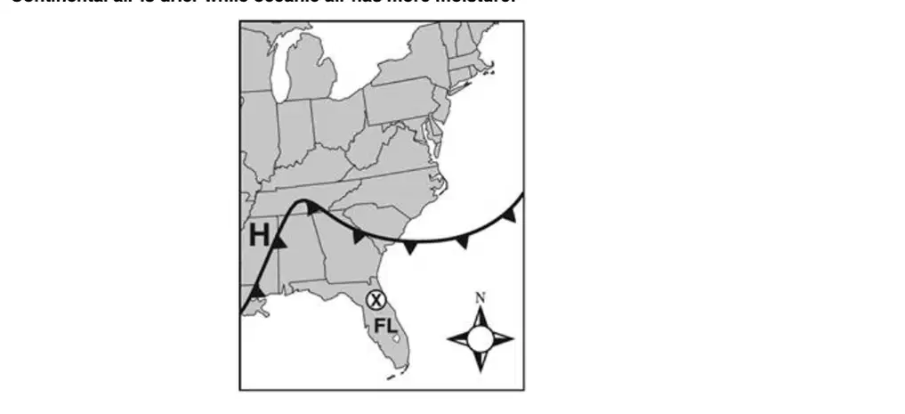
A high-pressure system (H) is moving to the southeast as shown on the weather map. Cold air is usually found north and west of a high-pressure system. Warm air is to the south and east of the front. Continental air is drier while oceanic air has more moisture. Based on this information, what is the BEST prediction for weather on the day after the system passes the point marked X?
wet air with cooler temperatures
drier air with cooler temperatures
wet air with warmer temperatures
drier air with warmer temperatures
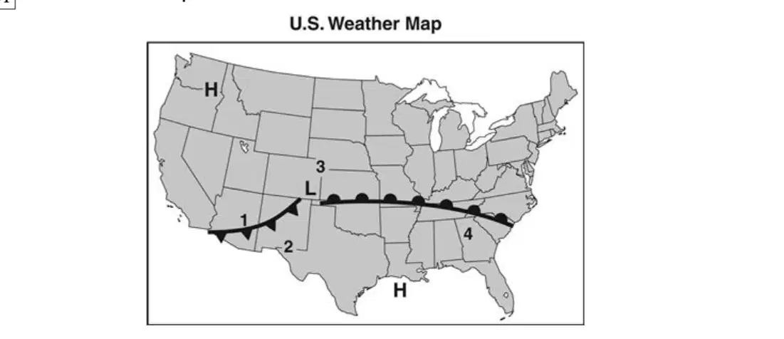
Look at the weather map. In which location, on the map, are thunderstorms MOST likely to occur within the next 24 hours (tomorrow)?
1
2
3
4

The diagram below shows a weather map. Which city is MOST likely to experience the cold front first?
Athens
Dayton
Marietta
Steubenville
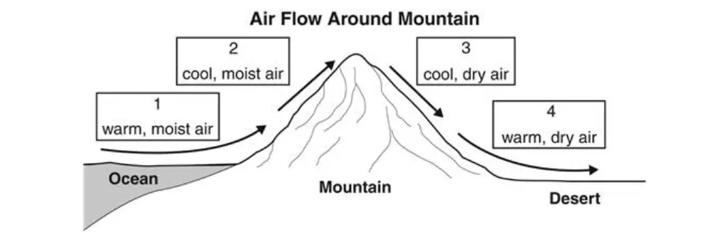
Mr. Turner's class is studying the water cycle. Mr. Turner shows the class a diagram of air flow around a mountain. Based on the diagram, at which point are clouds MOST likely to form?
1
2
3
4
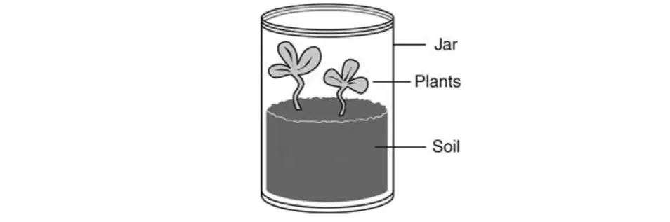
A student uses a terrarium to model the water cycle. Before putting the lid on the jar, the student waters the plants and puts the terrarium in a sunny window. What part of the water cycle occurs inside the terrarium only after the plants have been added?
precipitation
evaporation
condensation
transpiration
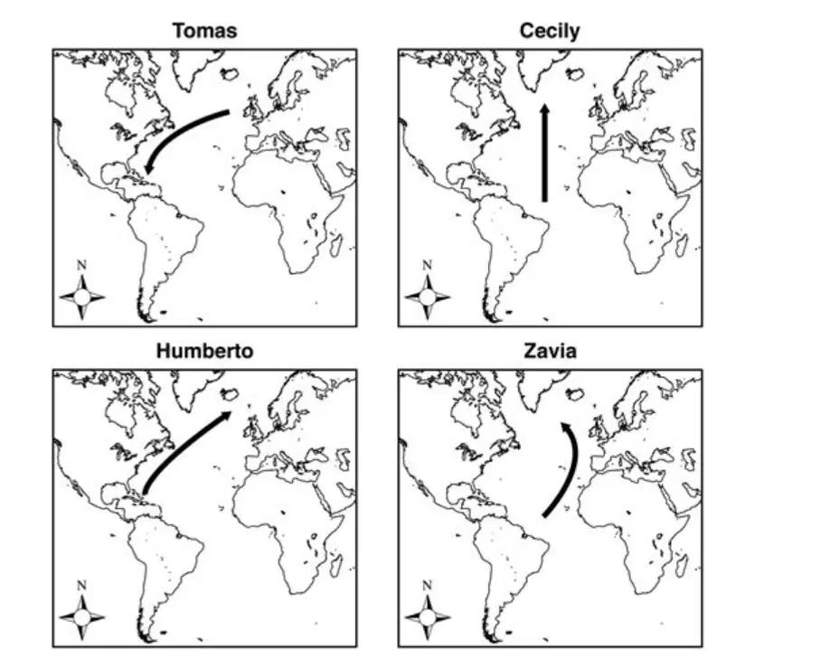
Mrs. Anderson gave her class a quiz about the Gulf Stream. The first question asked students to draw the path of the current. Four of the maps are below. Which student drew the path correctly?
Tomas
Cecily
Humberto
Zavia
In the Atlantic ocean, the Gulf Stream would be considered a ________.
tidal current
conductive current
freshwater stream
convection current
Ocean currents are driven by which two forces?
wind and cold seawater
gulf streams and warm seawater
sun and Earth's rotation
Earth's rotation and gulf streams
Cleveland, Ohio is farther south than London, England, but London has warmer average temperatures. Which statement BEST explains why London has warmer temperatures than Cleveland?
The cold air above the Gulf Stream gets blown toward Cleveland.
The warm air above the Labrador Current gets blown toward England.
The Labrador Current cools the air above it and the cool air gets blown toward Cleveland.
The Gulf Stream heats the air above it and the warm air gets blown toward the shores of England.
Which of the following BEST describes how air moves within the atmosphere?
air rises within high pressure systems
air sinks within low pressure systems
air flows from areas of high pressure to areas of low pressure
air flows from areas of low pressure to areas of high pressure
Which of the following are typically associated with high pressure systems?
cloudy skies
clear skies
hurricanes
tornadoes
Which sentence BEST describes how air pressure affects the movement of air?
Air flows from high to low pressure.
Air flows from low to high pressure.
Air does not flow between high and low pressure.
Air flows straight up into space when it runs into high or low pressure.
A mass of air under high pressure travels southward from the polar area toward the equator. How will Earth’s motion MOST likely affect this air mass?
The air mass will experience increased pressure.
The air mass will mix with a low-pressure system.
The air mass will reverse direction and travel back to the pole.
The air mass will appear to turn and move in a westerly direction.
Which invention has done the MOST to help predict weather and warn people of approaching storms?
satellites
airplanes
barometers
maps
The morning temperature in a city is 41°F. If a sunny, mild day is forecast, which temperature is most likely for 2:00 p.m.?
32°F
41°F
67°F
98°F
A student reads the following description of a region: "It has warm summers, moderate winters, and frequent rainfall." What information does this description BEST provide?
current weather
weather forecast
general climate
climate changes
A student states the weather is the same as the climate. Which response BEST tells the student the difference between weather and climate?
Weather is about the wind and the rain, but climate is about the clouds.
Weather is the conditions in one day, but climate is the conditions over a long time.
Weather is measured with tools like thermometers, but climate is measured with tools like forecasts.
Weather is recorded on charts, but climate is recorded on world maps.
Hurricanes that hit the east coast of the United States often start as low-pressure systems off the west coast of Africa. Which global winds move these hurricanes toward the United States?
polar easterlies
prevailing westerlies
northeast trade winds
southeast trade winds

