
 Worksheets
Unit 1 Practice Test
Total questions: 60
Worksheet time: 3600secs

North America
South America
Asia
Africa

Europe
Asia
Africa
Australia

Asia
North America
Europe
Africa


What country is number 1?
Turkey
Saudi Arabia
Afghanistan
Iran


What country is indicated by number 45?
Mali
Niger
Ghana
Chad

What country is identified by number 14?
Democratic Republic of Congo
South Africa
Angola
Tanzania
What country is identified by number 1?
Democratic Republic of Congo
South Africa
Angola
Tanzania

What country is this?
Russia
China
Taiwan

What country is this?
China
South Korea
Japan
Which state is located in the northwestern part of the United States?
Arkansas
Washington
Iowa
Colorado
Which province is located in the Atlantic region of Canada?
Manitoba
Saskatchewan
Prince Edward Island
New Brunswick
Which state is located in the southwestern part of the United States?
New York
Arizona
Ohio
Michigan
Which state is located in the central part of the United States?
Virginia
New Hampshire
Illinois
California

Identify #1 on the map
Argentina
Panama
Chile
Ecuador
Guatemala

Identify #3 on the map
Guatemala
Brazil
Panama
Argentina
Ecuador

Identify #6 on the map
Argentina
Cuba
Panama
Chile
Brazil

Papua New Guinea
Kiribati
Tonga
Fiji
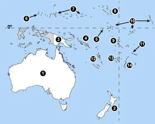
Name #13
Papua New Guinea
Fiji
Marshal Islands
Solomon Islands
Name #4
Papua New Guinea
Fiji
Marshal Islands
Solomon Islands

What country is this?
Romania
Albania
Kosovo
Ukraine

What country is this?
Switzerland
Luxembourg
Iceland
Austria

Name this country.
Germany
Poland
France
Spain

Name the country labeled 37.
Poland
Greece
Serbia
Russia


The two imaginary lines of latitude (parallels) that are located at 23.5 degrees north and 23.5 degrees south are called __________ and ____________.


Location D is located at which coordinates?
30oN, 90oW
90oN, 30oW
10oN, 40oW
30oN, 90oE

Which direction is highlighted?
Northeast
Northwest
North
West

Which direction is highlighted?
Northeast
Southeast
Southwest
Northweat
What is the imaginary line that divides the Earth into the Eastern and Western Hemispheres called?
A. Equator
B. Prime Meridian
C. Tropic of Cancer
D. Tropic of Capricorn


What is a map?
A 2D way of showing the 3D earth
a round circle
The object used to show directions
The imaginary lines that run through earth

What is a compass rose?
half of a circle that helps people find angles
a drawing showing different directions on a map
a device with a magnet that always points North
a pretty flower on a map that is red
Map Title
Tell us what the map is about
Compass Rose
Shows us the four cardinal directions
Bar Scale
Tells us the distance between two locations on a map
Lines of Latitude and Longitude
imaginary lines around earth that help us measure it
Map Key
Tells us what the difference symbols, pictures and colors mean/represent


Human Environment Interaction is:
HEI is where a place is.
HEI is the movement of ideas, goods, and people.
HEI is how people and their environment affect each other.
HEI is a group of places that share a common human or physical characteristic.
What do we use to find absolute location?
latitude and longitude
the equator and international dateline
a GPS and an XLP
landmarks and distances
What are the two type of location?
service
relative
absolute
environment
Lines of Longitude can be measured up to what degree?

