
 Worksheets
Geodesy 2 - Quiz I
Total questions: 20
Worksheet time: 11mins
........................ is a discipline within engineering that focuses on designing and analyzing systems where direct line-of-sight communication or observation is crucial.
LOS engineering
Geodetic surveying
Communication surveying
None of the above
Triangulation stations should be chosen on high ground so that all relevant stations are ................
accessible
inaccessible
intervisible
None of the above
If the distance between stations is large, the intervisibility is ascertained by knowing the .................. between the stations.
vertical angle
horizontal distance
azimuth
None of the above
h=D2/2R(1−2m)
m is ............
height of station above datum
coefficient of refraction
vertical distance
None of the above
The line of sight should be taken at least 3 m above the point of tangency T of the earth’s surface to avoid ..............
intervening ground
obstructions
grazing rays
none of the above
In ............................... the two points with known coordinates are occupied and sightings are taken to the unknown point.
three-point problem
resection
intersection
satellite station
In ...................................... the one point with unknown coordinates is occupied and sightings are taken to the known points.
Resection
intersection
radiation
None of the above

Figure shows (a) problem.
.......................... is a mathematical framework used to determine the positions of points in space or on a surface.
Coordinates
Origin
A coordinate system
None of the above
Astronomical observations for latitude, longitude, and azimuths are measured with reference to the ....................... at the point of observation.
normal direction
direction of gravity
ellipsoidal height
All of the above
The quantities Φ, Λ, and 𝐻 define the position of the observer with respect to the .................................
ellipsoid
geoid & the mean rotational axis of the earth.
WGS1984
None of the above
The geodetic coordinates are determined from ............................ observed on the earth's surface, reduced to the ellipsoid.
Triangulation or Trilateration
Astronomic observations reduced to ellipsoid
MSL
a and b
Ideally the origin of the rectangular coordinates system should be at the earth’s center of gravity; the system is known as ................
Horizon system
Geodetic Coordinate System
Average Terrestrial Coordinate System
None of the above
When the origin of the rectangular coordinates systemis NOT the earth’s center of gravity; the system is known as ...........
Geodetic Coordinate System
ECEF
Average Terrestrial Coordinate System
All of the above
In this system the coordinates U, V, W are expressed as functions of the observed azimuth A, zenith distances Z & spatial distance S
geodetic system
Horizon system
cartesian system
None of the above
What does a coordinate system provide a framework for?
Mathematical calculations
Determining the texture of objects
Describing the shape of objects
None of the above
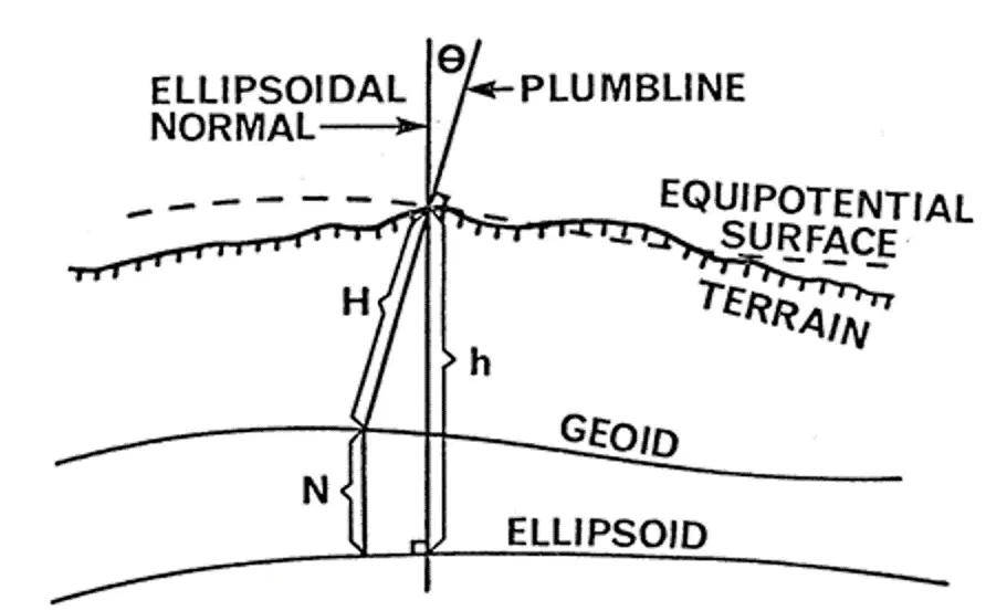
In this figure, theta is .............
deflection of the vertical
normal gravity
incidence angle
None of the above
It is measured along the curved plumb line and obtained from spirit levelling and gravity observations.
Normal height
geodetic height
orthometric height
undulation
is the height of the observer above the reference ellipsoid, measured along the ellipsoidal normal.
Ellipsoidal height
geiodal undulation
orthometric height
all of the above
Relation between Astronomic and Geodetic Coordinates is characterized by ..............
C.G of ellipsoid
deflection of the vertical
normal gravity
None of the above

