
Font size
 Worksheets
Introduction of GIS
Total questions: 50
Worksheet time: 38mins
By ‘spatial data’ we mean data that has:
Complex values
Location/coordinate values
Graphic values
Decimal values
What is ‘Attribute data’?
Specifies characteristics at that location, natural or human-created
Can be stored in a database table
Both A and B
None of the above
Numerous employees in your organization need access to the streets data that your team is responsible for maintaining in an enterprise database. From the options given below, what is the best way to handle access to these data? (Choose the best response)
Set the streets layer’s permissions to allow everyone in your enterprise full control
Set the streets layer’s permission to allow full control only to your team
Set the streets layer’s permission to allow full control only to your team and read-only access to the remainder of your enterprise
No action needed
How is a globe more accurate than a map?
a globe is a 3 dimensional model of the Earth, but a map is flat
a globe can show streets and roads, but a map cannot
a globe can show all of the continents at once, but a map cannot
a globe can be used to navigate from one town to another, but a map cannot
Maps are the least useful tool in geography.
True
False
Google maps is an example of a GIS.
True
False
What is the most powerful close in GIS?
Power Close
Negative Close
Trial Close
Pros and Cons
Which of the following is not a hardware component of GIS?
A computer screen
GPS coordinates
A plotter
A scanner

Select all the examples of line data shown in the image.
Arterial Route
Contour Line
Telephone Line
Row of trees
A disadvantage of secondary data is...
that it takes time to collect.
that it is expensive to obtain.
that map projections may differ.
The conventional sign for cultivated land on a topographic map is an example of ...
point data
line data
polygon data
Vector data is easier to store on a computer as it takes less file space.
TRUE
FALSE
Meta data would describe....
who collected a set of data.
how the data was collected.
when the data was collected.
all of the above are true.
Attribute data could be collected via a survey.
True
False
In case study, Earthquake in Japan triggers
Flood
Soil erosion
Heavy Rainfall
Tsunami
The coordinate system provides
spatial reference
reference data
Relationship among the data
None of the above
Geographic coordinate system expressed in
Maps
Satellite Images
longitude and latitude values
Numerical Values
The process of projection transforms the Earth’s surface to a
Plane Surface
Spherical Surface
Elliptical Surface
Statistical Data
Which of the statement is / are correct?
Latitude: the angle north or south of the equatorial plane
Longitude: the angle east or west of the equatorial plane
Longitude: the angle east or west from the prime meridian
Latitude: the angle north or south from the prime meridian
Based on preserved property, map projections are classified into how many classes
3
4
5
6
The accuracy of data analysis depends on the accuracy of ________________ in terms of their location and shape
Surveying Map
Satellite Map
Spatial features
Scanners
Utility networks includes
water mains
sewage lines
electrical circuits
Transportation networks includes
roads
railroads
flight paths
All the above
What is the primary function of GPS in the context of geospatial analysis?
Generating satellite images
Determining precise locations on Earth's surface
Creating digital elevation models
Analyzing spatial relationships in GIS
Which of the following statements best describes the difference between GPS and GIS?
GPS provides real-time spatial data, while GIS focuses on spatial data analysis.
GPS is used for collecting spatial data, while GIS is used for navigation purposes
GPS uses satellites to determine location, while GIS integrates and analyzes spatial data.
GPS and GIS are interchangeable terms for the same technology
What role does remote sensing play in environmental monitoring?
Identifying spatial patterns in GIS data
Collecting ground-truth data for GPS analysis
Observing Earth's surface from a distance using sensors
Navigating through rugged terrain using satellite imagery
How can GPS, GIS, and remote sensing data be integrated to monitor changes in land cover over time?
By analyzing GPS trajectories of mobile devices
By overlaying satellite imagery onto GIS layers
By converting GPS coordinates to digital elevation models
By conducting field surveys with GPS devices
What are some challenges associated with the integration of GPS, GIS, and remote sensing data?
Data accuracy, interoperability, and processing speed
GPS signal interference, GIS software compatibility, and sensor calibration
Satellite coverage, GIS database management, and remote sensing resolution
GPS hardware cost, GIS data storage, and remote sensing data licensing
In what ways can the integration of GPS, GIS, and remote sensing contribute to disaster management and response?
By predicting future natural disasters based on historical GIS data
By providing real-time GPS navigation for emergency responders
By monitoring environmental changes using remote sensing imagery
By creating GIS-based evacuation maps using GPS coordinates
What is the significance of spatial data interoperability in the integration of GPS, GIS, and remote sensing?
It ensures that GPS coordinates are accurate and up-to-date.
It enables seamless exchange and integration of spatial data between different systems
It improves the resolution of satellite imagery for remote sensing applications
It reduces the cost of GIS software licenses for spatial data analysis
How might advancements in geospatial technology shape the future of environmental management?
By improving the accuracy and accessibility of GPS data
By enabling real-time monitoring of environmental changes using GIS
By integrating artificial intelligence with remote sensing for automated analysis
All of the above
Remote sensing is use for ______________.
Detecting plant health
Measuring snowpack
Monitoring wetlands
All of the above

In which famous cartographic projection Europe and North America (the entire northern part including Greenland for example) appear much larger than they really are?
Orthographic
Goode-Homolosine
Mercator
Fuller

It is not possible to reflect the surface of a sphere (3D) in a plane (2D) in a completely "real way" (a 'projection' method is needed).
True
False
True or false: Globes provide a three-dimensional view of the Earth. They provide the most accurate view of the world, but have limitations in their use.
True
False
True or false: Globes show more detail and are easier to transport than maps are.
True
False
True or false: All world map projections create distorted images of the Earth to some degree. These distortions relate to size, shape, direction, and distance.
True
False
True or false: The cartographer’s purpose and the projection used to create a map influence what information is accurate and what is distorted.
True
False
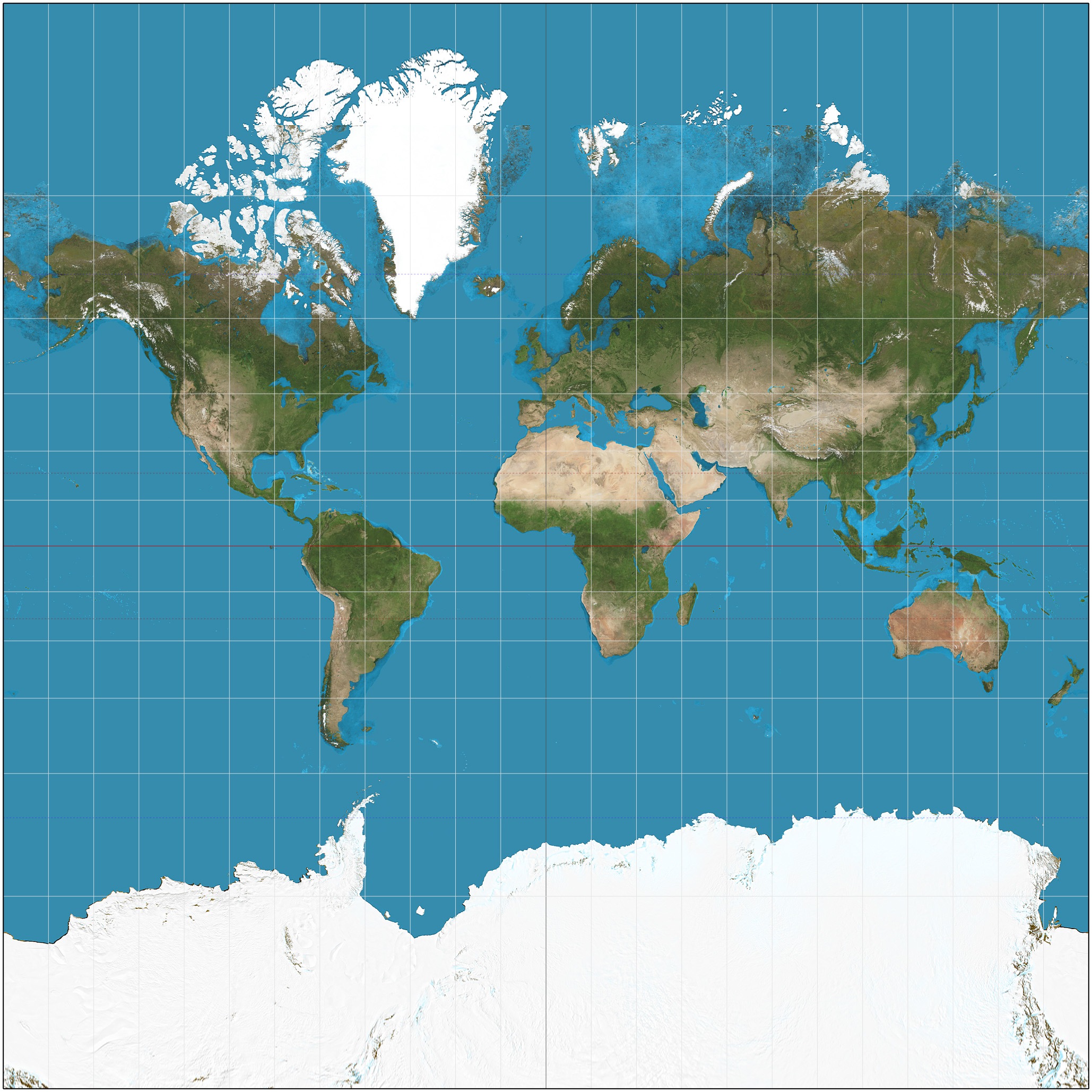
Which projection is this?
Peters
Robinson
Mercator
Useful for navigation because it shows true direction and shape
conic projection
cylindrical projection
flat-plane projection
Useful for showing areas with long east-west dimensions
conic projections
cylindrical projections
flat-plane projections
Based on a plane touching the globe at one point, such as a pole
conic projections
cylindrical projections
flat-plane projections
By 'Spatial data' we mean data that has
Complex values
Positional values
Graphic values
Decimal values
Which of the following statements are true related with GIS?
Natural phenomena are usually fields
Man-made phenomena are usually objects
Both ‘1’ & ‘2’ are true
None of the above
Which of the following do geographers use to compare a variety of spatial data by creating digitized representations of the environment by combining layers of spatial data, and creating maps in which patterns and processes are superimposed?
GPS
GIS
Scale
Maps
Which of the following are NOT components of GIS?
Data
Layers
Hardware
Software
Globe

