
 Worksheets
Intro to Geography Review
Total questions: 43
Worksheet time: 22mins
Name
Class
Date
1.
The study of the physical features of the earth and his atmosphere and of human activity as it affects and is affected by these is called _________________________.
a)
anthropology
b)
biology
c)
geography
d)
sociology
2.
Which of the following is NOT one of the FIVE themes of geography?
a)
Human-Environment Interaction
b)
Location
c)
Movement
d)
Population
3.
__________________________ is the theme of geography that explains how people affect the environment and how the environment affects people.
a)
Location
b)
Place
c)
Human-Environment Interaction
d)
Movement
e)
Regions
4.
_____________________ is the theme of geography that involves a group of places that have common characteristics.
a)
Location
b)
Place
c)
Human-Environment Interaction
d)
Movement
e)
Regions
5.
_____________________ is the theme of geography that provides a way of locating places.
a)
Location
b)
Place
c)
Human-Environment Interaction
d)
Movement
e)
Regions
6.
_______________________ is the theme of geography that includes the characteristics of a location.
a)
Location
b)
Place
c)
Human-Environment Interaction
d)
Movement
e)
Regions
7.
________________________ is the theme of geography that explains how people, ideas and animals move from one place to another.
a)
Location
b)
Place
c)
Human-Environment Interaction
d)
Movement
e)
Regions
8.
________________________ is the exact point where a place is located, which is determined using latitude and longitude.
a)
Absolute Location
b)
Relative Location
9.
__________________________ is where a place is in relation to other places.
a)
Absolute Location
b)
Relative Location
10.
Which of the following is NOT a PHYSICAL characteristic of a place?
a)
Climate
b)
Population
c)
Bodies of Water
d)
Landforms
11.
Which of the following is NOT a HUMAN characteristic of a place?
a)
Animal Life
b)
Religion
c)
Architecture
d)
Political Systems
12.
Which of the following is a way in which humans DEPEND on the environment for their basic needs?
a)
Food
b)
Shelter
c)
Clothing
d)
All of the Above
13.
Which of the following is a way humans MODIFY their environment?
a)
Clothing Choices
b)
Building Dams
c)
Air Conditioning
d)
Fire for Warmth
14.
Which of the following is a way in which humans ADAPT to their environment?
a)
Heating homes in winter
b)
Air conditioning homes in summer
c)
Clothing choices
d)
All of the Above
15.
Which of the following is NOT a way places are connected to one another by movement?
a)
People
b)
Ideas
c)
Landforms
d)
Physical Systems (wind)
16.
Which of the following is NOT a human characteristic of a place?
a)
Economic Characteristics
b)
Characteristics of Soil and Vegetation
c)
Political Characteristics
d)
Cultural Characteristics
17.
A large landmass on the Earth's surface is called a _________________.
a)
Continent
b)
Island
c)
Territory
d)
Country
18.
The ______________________ is the body of water which covers approximately 71% of the surface of the Earth.
a)
Sea
b)
Lake
c)
Pond
d)
Ocean
19.
What ocean is located between North America and Africa?
a)
Pacific Ocean
b)
Indian Ocean
c)
Atlantic Ocean
d)
Arctic Ocean
20.
What ocean is located between North America and Asia?
a)
Pacific Ocean
b)
Indian Ocean
c)
Atlantic Ocean
d)
Arctic Ocean
21.
What ocean is located near Antarctica?
a)
Arctic Ocean
b)
Southern Ocean
c)
Pacific Ocean
d)
Atlantic Ocean
22.
What ocean is located just south of India?
a)
Arctic Ocean
b)
Southern Ocean
c)
Indian Ocean
d)
Atlantic Ocean
23.
What ocean is located north of Europe?
a)
Arctic Ocean
b)
Southern Ocean
c)
Pacific Ocean
d)
Atlantic Ocean
24.
A ___________________ tells the subject of the map or globe.
a)
Legend
b)
Scale
c)
Symbol
d)
Title
25.
A three-dimensional, or spherical representation of the Earth is called a ____________________________.
a)
Map
b)
Globe
26.
A two-dimensional, or flat, representation of the Earth is called a _______________.
a)
Map
b)
Globe
27.
__________________ represent information such as natural resources, economic activities and cities on a map.
a)
Scales
b)
Symbols
c)
Compass Rose
d)
Labels
28.
__________________represent different kinds of information. For example, blue usually represents water.
a)
Colors
b)
Scales
c)
Legends
d)
Labels
29.
A ___________________shows how much distance on Earth is represented by distance on the map or globe.
a)
Legend
b)
Compass Rose
c)
Scale
d)
Symbol
30.
A ___________________, or key, explains what the symbols and colors on the map or globe represent.
a)
Legend
b)
Compass Rose
c)
Scale
d)
Title
31.
A ______________________ shows the directions North, South, East and West, which are also known as cardinal directions.
a)
Legend
b)
Compass Rose
c)
Scale
d)
Title
32.
Lines of _________________________ are imaginary lines that run north to south from the North Pole to the South Pole.
a)
Latitude
b)
Longitude
33.
Lines of ______________________ are imaginary lines that run east to west, parallel to the Equator.
a)
Longitude
b)
Latitude
34.
The ________________________ is a line of latitude that measures 0 degrees, dividing the Earth into the Northern and Southern Hemispheres.
a)
Prime Meridian
b)
Equator
35.
The ____________________________ is a line of longitude that measures 0 degrees, dividing the Earth into the Eastern and Western Hemispheres.
a)
Prime Meridian
b)
Equator
36.
A ____________________ map shows the natural features of geography, such as landforms, oceans and other bodies of water.
a)
Thematic
b)
Political
c)
Geothermal
d)
Physical
37.
A ________________________ map shows features that humans have created, such as countries, states and cities.
a)
Thematic
b)
Political
c)
Geothermal
d)
Physical
38.
A __________________ map is a map about a specific theme such as an economic activity, natural resources, population, etc.
a)
Thematic
b)
Political
c)
Geothermal
d)
Physical
39.

Which of the following map projections is represented in this picture?
a)
Azimuthal Projection
b)
Mercator Projection
c)
Homolosine Projection
d)
Robinson Projection
40.

Which of the following map projections is represented in this picture?
a)
Azimuthal Projection
b)
Mercator Projecdtion
c)
Homolosine Projectdion
d)
Robinson Projection
41.

Which of the following map projections is represented in this picture?
a)
Azimuthal Projection
b)
Mercator Projection
c)
Homolosine Projection
d)
Robinson Projection
42.
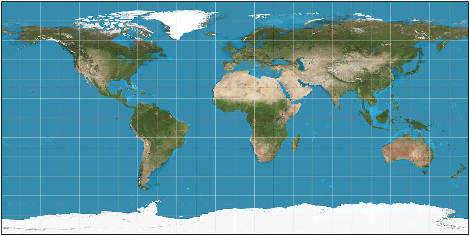
Which of the following map projections is represented in this picture?
a)
Azimuthal Projection
b)
Mercator Projection
c)
Homolosine Projection
d)
Robinson Projecdtion
43.
Mapmakers are called __________________________.
a)
Geographers
b)
Historians
c)
Cartographers
d)
Anthropologists
100 %

