
 Worksheets
1st 9 Weeks Exam Review
Total questions: 44
Worksheet time: 38mins
Students worked in groups to design solar ovens using various materials.
Which design would be most effective at heating up the inside of the boxes?
(All boxes are the same size and are made of identical material.)


Which of the following are reasons to use renewable resources for energy sources rather than nonrenewable resources?
There is a limited supply of renewable resources.
Renewable resources contribute to global warming.
There is a continuous supply of renewable resources.
Renewable resources can be replenished in a short time.
Renewable resources are much less polluting to the environment.

Which statements below concerning energy use are accurate?
[Select two that apply]
The total consumption of energy through renewable resources reached approximately 70 trillion BTUs.
The total consumption of energy through renewable resources reached approximately 200 trillion BTUs in 2015.
Scientists predict that by 2025 this graph will likely show dramatically different distributions of energy consumption.
Mississippi is not dependent on fossil fuels.
Which BEST describes a renewable resource?
available in limited quantities
unlimited quantities available
replenishes naturally over time
able to be replenished artificially
Match the resources from the column on the left to the classification on the right.
[Use ALL choices]
Oil
Nonrenewable
Biomass
Renewable
Natural Gas
Nonrenewable
Water
Renewable
Coal
Nonrenewable
______________ energy harnesses heat generated from within the Earth's interior.
Hydropower
Geothermal
Biomass
Solar
Classify each natural resource listed in the table below as either "Renewable" or "Nonrenewable".
Biomass
Geothermal
Wind
Solar
Coal
Natural Gas
Petroleum (Oil)
9.
Match the type of resource from the column on the left to the correct description on the right.
Biomass
made from recently living material
Solar Energy
derived from sunlight
Wind Energy
generated from air movement
Geothermal Energy
derived from heat within the Earth
Hydropower
produced from flowing water
Which of the following would be a solution to reduce the GREATEST amount of greenhouse gases released into the atmosphere?
[ Select TWO choices ]
continue to create alternative fuel sources
reduce livestock farming
find alternative sources for fertilizing crops
protect more forests from deforestation
begin increasing the production of greenhouses
Which of the following lists only NONRENEWABLE resources?
oil, coal and water
natural gas, oil, and water
coal, natural gas, oil
water, coal and natural gas
Match the type of resource to the societal disadvantage associated with the resource.
[Use ALL choices]
Biomass
deforestation
Geothermal
drilling disrupts ecosystems
Wind
interferes with migrating birds
hydroelectric
dams disrupt aquatic habitats
People in certain regions use solar cookers to cook food. What is the advantage of using a solar cooker
shorter cooking time
cooking in any weather
ability to cook large meals
no emission of harmful gases
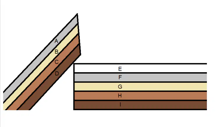
Examine the diagram.
A fossil hunter came upon the strange rock formation shown above. After studying the fossils contained in each strata of the rock, she found fossils similar in age and species in Layers A and F. She found other ages and species of fossils that matched in Layers B and G.
What is the most likely explanation for the age and species of fossils she could expect to find in Layers C and H?
The fossils in Layer C should be older than those found in Layer H.
The fossils in Layer C should be younger than those found in Layer H.
The fossils in Layer C should be of similar species and ages as those in Layer H.
The fossils of these layers will have no common characteristics.
In (a) weathering, rocks are broken down into smaller pieces without changing them.
In (a) weathering, rocks are broken down and changed into different substances.
In parts of inland Mississippi, there are deposits of sediment where fossils of shark teeth, shells, and other aquatic organisms can be found.
Which of the following is the MOST LIKELY explanation for these deposits?
The state of Mississippi used to be covered by a shallow tropical area.
Dirt containing ocean fossils was transported to inland locations.
The state of Mississippi once supported a tropical rainforest ecosystem.
The movement of glaciers across North America produced fossil deposits.
In terms of strata and the fossil record, what is a simple explanation for the Law of Superposition?
The oldest rock layers are found closest to the surface.
Sedimentary rock layers have the greatest amount of fossils.
The youngest rock layers are found closest to the surface.
Igneous and metamorphic rock layers are located only near the surface.
Which of the following is not a characteristic of an index fossil?
They evolved in shallow seas no longer in existence.
They have short vertical ranges (through geological time).
They have wide geographic distributions.
They are distinctive/easily recognized.
An intrusion is always ___________ than the rock layers around it. Intrusions occur when ______________ cools beneath the surface.
younger; magma
older; igneous rock
younger; sedimentary rock
older; metamorphic rock
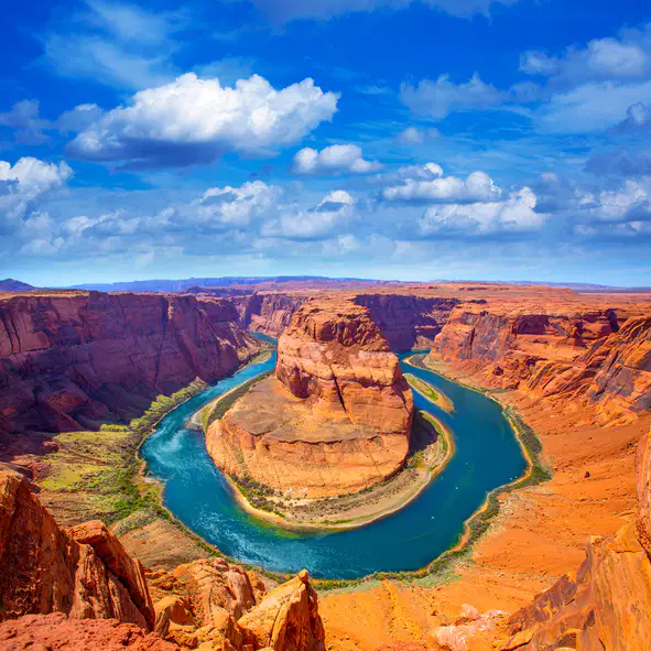
Examine the image.
The image shows Horseshoe Bend, a popular location in the Grand Canyon.
The Grand Canyon was formed through constant _________________ from the Colorado River.
deposition
erosion
weathering
sediment movement
In which type of rock are the most fossils typically found?
Sedimentary rocks since they form in water where animal remains collect.
Intrusive igneous rocks since they form underground where fossils are undisturbed.
Sedimentary rocks since they form at low pressure and temperature preserving fossils.
Intrusive igneous rocks since these form under high pressure, help to compress the remains in deep layers.
Which characteristic makes a fossil an excellent index fossil?
It is large and easy to spot.
It is the oldest fossil ever found.
It lived for a short period but in many places.
It has a different look and color compared to most fossils.
A group of researchers plan to investigate the geological history of a region by studying the fossils present in the rocks. Which rock from the region should the researchers choose to carry out the investigation?
a young igneous rock formed beneath Earth
an old sedimentary rock exposed by wind erosion
a young volcanic rock formed from the erupted lava
an old metamorphic rock that rose to the surface after geologic uplift
Select the layer of Earth that has convection currents that cause Earth's plates to move.
The effect of a divergent boundary is the formation of a __________.
plateau
rift valley
subduction zone
The effect od a convergent boundary is the formation of a(n) ___________________.
mid-ocean ridge
ocean trench
tectonic plate

Examine the figure and answer the question.
What theory is depicted in the image?
Theory of Evolution
Theory of Continental Drift
Theory of Natural Selection
Theory of Permanentism
Earth's tectonic plates move on the Earth's surface. Scientists believe forces under the Earth's surface cause this movement. Which of the following BEST explains the cause of this movement?
The core is a hot, dense ball of (mostly) iron. Heat is transferred by conduction to the plates and it is the cause of plate movement.
Radiation from the Sun heats up the surface of the Earth, causing the plates to move.
Convection currents within the Earth are the driving force behind plate movement.
The core is boiling liquid material. The gases created by this boiling action cause the plates to move.
The core is boiling liquid material. The gases created by this boiling action cause the plates to move.
Eurasia
Pangaea
Mesozoic
Greater
Which of the following can be found at a divergent boundary?
[ Select ALL that apply ]
subduction zone
seafloor spreading
deep ocean ridge
deep sea trench
new oceanic crust

The image shows the movement direction of two plates, A and B.
Based on the direction of movement, which two natural events are most likely to occur around the region where plates meet?
the occurrence of flooding
the formation of sinkholes
the formation of rift valleys
the formation of mountains
the occurrence of earthquakes
Mountains are a result of natural events. How are mountain ranges, like the Himalayas, formed?
erosion by rain and wind
the impact of meteroites
melting of glaciers over thousands of years
tectonic plates colliding and pushing upwards

The image shows two tectonic plates moving away from each other.
What must have caused the plates to move apart from each other?
the gravitational pull of the Moon
convection currents in the mantle
increase in the Earth's magnetic field
decrease in the weight of the tectonic plate
The image shows two tectonic plates moving away from each other.
What type of boundary is shown?
Convergent
Divergent
Transform
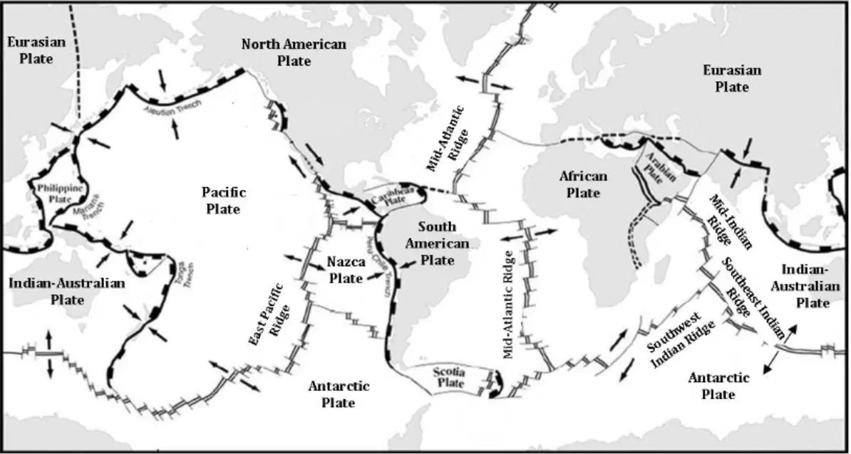
Examine the tectonic plate diagram.
Which of the following is MOST LIKELY to occur at the boundary between the Nazca Plate and the South American Plate?
hurricanes
rift valleys
strik-slip faults
earthquakes
A new interactive map is created showing regions at high risk for wildfires, floods, and landslides. What would be the most appropriate use of this natural hazard map?
To promote development in high-risk hazard zones.
To identify hazardous areas for targeted tourism opportunities.
To help communities understand vulnerabilities and plan disaster preparedness.
To determine where to remove the environmental regulations and allow more construction.
In a coastal town, the local government installed Doppler radar. What is the main advantage of using Doppler radar?
It can measure soil moisture accurately.
It monitors pollution levels and air quality.
It can measure wave heights and ocean currents.
It provides more accurate local weather predictions.
Which two changes could protect a local subway system that often experiences flooding?
waterproof sealing
adding more lights
more seating areas
elevating entrances
installing solar panels
A meteorologist is tasked with forecasting hurricanes. Which technology should the meteorologist primarily use?
barometer
radar
seismometer
thermometer
Which two technologies give accurate real-time detection and early warning for tsunamis?
Doppler radar
buoy systems
seismometers
thermal cameras
weather satellites
A mountainous region experiences frequent landslides that damage roads in the area. Which engineering solution would best reduce road damage from landslides in this region?
building levees along the roads
paving roads with cobblestones
constructing cemented highways
building retaining walls along the roads
A town located close to a river experiences periodic flooding. What type of structure can best mitigate the impact?
bridge
levee
tunnels
retaining wall
How can the study of natural hazard history inform urban planning and disaster preparedness for future events?
It provides insights into the cultural history of a region.
It guarantees complete protection from future natural hazards.
It has no relevance to urban planning or disaster preparedness.
It helps identify vulnerable areas and plan for evacuation routes and shelters.
On October 28th, 2012, the GOES-13 satellite was able to capture a picture of a storm spanning a horizontal distance of about one-third of the U.S. continental landmass. The storm first hit the state of New Jersey, and then gradually moved northeast. This storm caused billions of dollars in damage and resulted in over 30 deaths. These types of storms rotate counterclockwise and typically lose strength as they move across land.
These storms are known as __________________ and at the center of the rotating storm is a small area of calm weather and clear skies known as the eye.
tornadoes
earthquakes
hurricanes
blizzards

