wayground logo

Free Printable Worksheets

Font size

S
M
L
XL
Worksheets

Ch 2: Mapping Our World

Total questions: 71

Worksheet time: 57mins

Name
Class
Date
1.
What line of latitude is located at 0 degrees?
a)
Equator
b)
Tropic of Cancer
c)
Arctic Circle
d)
Prime Meridian
2.
What line of longitude is located at 0 degrees?
a)
Equator
b)
Tropic of Cancer
c)
Arctic Circle
d)
Prime Meridian
3.
Which direction do lines of latitude run?
a)
east and west
b)
north and south
c)
east and south
d)
west and north
4.
Which direction do lines of longitude run?
a)
east and west
b)
north and south
c)
east and south
d)
west and north
5.
What line of LATITUDE is Point A located?
a)
60N
b)
105W
c)
150W
d)
48o N
6.
What line of LONGITUDE is Point A located?
a)
60N
b)
105W
c)
150W
d)
48o N
7.
What line of LATITUDE is Point B located?
a)
105W
b)
60N
c)
150W
d)
80o W
8.
What line of LONGITUDE is Point B located?
a)
105W
b)
60N
c)
150W
d)
80o W
9.
What line of LONGITUDE is Point C located?
a)
105W
b)
60N
c)
150W
d)
80o W
10.
What line of LATITUDE is Point C located?
a)
105W
b)
60N
c)
48N
d)
80o W
11.
What line of LATITUDE is Point D located?
a)
105W
b)
34N
c)
48N
d)
80o W
12.
What line of LONGITUDE is Point D located?
a)
105W
b)
34N
c)
48N
d)
80o W
13.
What line of LATITUDE is Point E located?
a)
105W
b)
34N
c)
22N
d)
80o W
14.
What line of LONGITUDE is Point E located?
a)
105W
b)
34N
c)
22N
d)
80o W
15.

Columbus is located on what line of longitude?

a)

83 W

b)

81 W

16.
What city is located at about 39 degrees North latitude and 108 degrees West longitude?
a)
Durango
b)
Delta
c)
Boulder
d)
Denver
17.
a)
The map show the lines of longitude.
b)
The map shows the lines of latitude.
18.
a)
The map shows lines of longitude.
b)
The map shows lines of latitude.
19.
Latitude and longitude are measured in ________.
a)

cups

b)

gallons

c)

degrees

d)

Fahrenheit

20.
A _______________ is exactly half of the earth.
a)
Equator
b)
Hemisphere
c)
Tropic of Cancer
d)
Arctic Circle
21.

The equator divides the Earth into what two hemispheres?

a)

Eastern and Southern

b)

Northern and Southern

c)

Western and Eastern

d)

Northern and Western

22.
Lines of longitude are also called  ____________.
a)
Hemispheres
b)
Meridians
c)
parallels
d)
International Date Lines
23.
The Prime Meridian separates the Earth into what two hemispheres?
a)
Northern and Southern
b)
Western and Eastern
c)
Northern and Eastern
d)
Southern and Western
24.
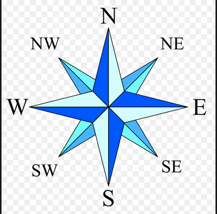
What is this object known as?
a)
map symbol
b)
map key
c)
map scale
d)
compass rose
25.
When measuring the lines of latitude, always begin with the ______, which represents 0
degrees.
a)
Prime Meridian
b)
Equator
c)
Longitude
d)
North Pole
26.
When measuring the lines of longitude, always begin with the _______, which represents 0 degrees.
a)
South Pole
b)
Equator
c)
Prime Meridian
d)
Latitude
27.
North America is located in the: 
a)
Eastern & Southern Hemispheres
b)
Northern & Western Hemispheres
c)
Northern & Eastern Hemispheres
d)
Western & Southern Hemispheres
28.

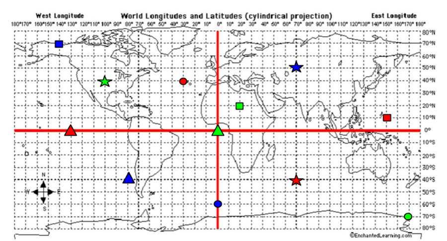
What are the coordinates for the RED star?

a)

40*S, 70*E

b)

40*N, 30*W

c)

0*, 130*W

d)

10*N, 150*E

29.

What are the coordinates for the RED Square?

a)

40*S, 70*E

b)

40*N, 30*W

c)

0*, 130*W

d)

10*N, 150*E

30.
What city is located at 32 degrees south and 150 degrees east?
a)
Shanghai
b)
Sydney
c)
Durban
d)
Calcutta 
31.
Which city is located at 38 degrees north and 120 degrees west?
a)
San Fransisco 
b)
New York
c)
New Orleans
d)
London
32.
Which continent is located completely north of the Equator and west of the Prime Meridian?
a)
Asia
b)
Europe
c)
North America 
d)
South America
33.
Which continent is completely south of the Equator and east of the Prime Meridian?
a)
Antartica 
b)
South America
c)
North America 
d)
Australia 
34.
What are the coordinates for the city of New Orleans? 
a)
30 degrees north and 90 degrees west
b)
60 degrees north and 30 degrees east
c)
30 degrees north and 120 degrees east
d)
35 degrees north and 70 degrees west
35.
If you were at 30 degrees south and 60 degrees west, which continent would you be in?
a)
Europe
b)
Africa
c)
South America
d)
Australia 
36.
If you were located at 30 degrees south and 90 degress east, what ocean would you be in?
a)
Indian Ocean
b)
Atlantic Ocean
c)
Arctic Ocean
d)
Pacific Ocean
37.
Which continent is located at 60 degrees north and 120 degrees west?
a)
Asia 
b)
North America
c)
Europe
d)
Africa
38.
What ocean would you be in if you were at 30 degrees south and 150 degrees west?
a)
The Atlantic Ocean
b)
The Arctic Ocean
c)
The Pacific Ocean
d)
The Indian Ocean
39.
What ocean would you be in if you were at 30 degrees south and 150 degrees west?
a)
The Atlantic Ocean
b)
The Arctic Ocean
c)
The Pacific Ocean
d)
The Indian Ocean
40.
Is the Tropic of Cancer ABOVE the Equator or BELOW the Equator?
a)
Above
b)
Below
41.
Is the Tropic of Capricorn ABOVE the Equator or BELOW the Equator?
a)
Above
b)
Below
42.
What city is located at about 39 degrees North latitude and 108 degrees West longitude?
a)
Durango
b)
Delta
c)
Boulder
d)
Denver
43.
What city is located at 40 degrees North latitude and about 105 degrees West longitude?
a)
Colorado Springs
b)
Boulder
c)
Denver
d)
Durango
44.
Lines of Latitude can be measured up to what degree?
a)
150 degrees
b)
180 degrees
c)
90 degrees
d)
100 degrees
45.
What is the highest elevation on this map?
a)
Over 320 meters
b)
Over 450 meters
c)
Over 220 meters
d)
Over 380 meters
46.
Which topographic map matches formation C?
a)
1
b)
2
c)
3
d)
4
47.
If contour lines are close together, then the slope is
a)
gentle
b)
steep
c)
flat
d)
going up and down
48.
When you move from one contour line to another, the elevation
a)
stays the same
b)
goes up or down
c)
disappears
d)
is below sea level
49.
What are the curved lines on a topographic map called?
a)
contour lines
b)
contour intervals
c)
slope
d)
elevation
50.
How many peaks are on the map? (hill tops)
a)
4
b)
3
c)
2
d)
1
51.
What do contour lines that are farther apart represent?
a)
waterfall
b)
steep area
c)
gentle slope
d)
river
52.

Which side is steeper?

a)

The left side of the hill

b)

The right side of the hill

53.

Match the topographic map to its profile.

a)
b)
c)
d)
54.
Determine the contour interval:
a)
5 m
b)
10 m
c)
15 m
d)
20 m
55.

The distance between contour lines is called...

a)

Contour interval

b)

Contour line

c)

Colors

d)

Mountains

56.
Which map projection makes land near the poles seem gigantic (like Antarctica and Greenland)?
a)
Lambert
b)
Mercator
c)
Robinson
d)
Eckert IV
57.
The change in shape, size, or location of a place when shown on a map.
a)
Map Projection
b)
Distortion
58.
Which projection is this?
a)
Conic
b)
Mercator
c)
Eckert IV
d)
Robinson
59.
Which projection is this?
a)
Robinson
b)
Mercator
c)
Eckert IV
d)
Goode's Homolosine
60.
As you travel from west to east, does it get later or earlier?
a)
Earlier
b)
Later
61.

If it was 5:30 A.M in Los Angeles, USA, what time is it in New York City, USA?

a)

6:30 A.M

b)

8:30 A.M

c)

12:30 P.M

d)

9:30 A.M

62.
What is a map scale?
a)
a tool to measure distance
b)
a tool to tell direction
c)
a tool to start a fire
d)
a tool to build a house
63.

On a scale drawing, the distance between two parks is 4 inches. If the scale of the drawing is 1 inch = 10 miles, what is the actual distance between the two parks?

a)

14 miles

b)

40 miles

c)

20 miles

d)

50 miles

64.

What is one of the main advantages of remote sensing?

a)

It requires physical presence in the field

b)

It is always free to use

c)

It does not require any technology

d)

It can analyze large areas quickly

65.

Which of the following is a disadvantage of remote sensing?

a)

It is easy to interpret data

b)

It requires expensive equipment

c)

It can be done by anyone

d)

It provides instant results

66.

What is based on a global network of satellites that transmit radio signals from medium earth orbit?

a)

A global positioning system (GPS)

b)

A geographic information system (GIS)

67.

Which of the following is GPS used for?

a)
Navigation
b)
Resource Distribution
c)
Irrigation 
d)
Energy Tracking
68.

This is an example of ________

a)

GPS

b)

GIS

c)

MPS

d)

MAPS

69.
What does GPS stand for?
a)

Global Positioning System

b)

Geographic Information System

c)

Land forms

d)

Map Making

70.

GIS stands for

a)

Geographic Information System

b)

Generic Information System

c)

Geological Information System

d)

Geographic Information Sharing

71.

I have layered data that shows me where is the best area to buy a house. It shows me the land, crime, and income of the area. This is

a)

GPS

b)

GIS

c)

MR. HeLP

d)

Regions