
 Worksheets
Nav - Maps & Charts
Total questions: 41
Worksheet time: 21mins
Which of the following is a property of the Mercator Chart?
Rhumb lines are curved lines concave to the equator
Rhumb lines are straight lines
Rhumb lines are curved lines convex to the equator
Which of the following is a property of the Lambert Projection Chart?
Rhumb lines are straight lines
Rhumb lines are curved lines concave to the nearer pole
Rhumb lines are curved lines convex to the nearer pole
Which of the following text states the two qualities that make an aeronautical chart 'orthomorphic'?
(1) Constant scale and shape over the entire chart, and
(2) parallels of latitude and meridians of longitude intersect at right angles
(1) Constant scale or constant scale expansion in all directions over a small area, and
(2) parallels of latitude and meridians of longitude intersect at right angles
(1) Constant scale or constant scale expansion in all directions over a small area, and
(2) parallels of latitude and meridians of longitude intersect at constantly varying angles
(1) Constant scale and shape over the entire chart, and
(2) parallels of latitude and meridians of longitude intersect at constantly varying angles
A Mercator Chart is useful for navigating …?
at all latitudes
between 30°N and 30°S
between 70°N and 70°S
close to the poles
Where on a Lambert's Conformal Chart is the scale compressed?
outside the standard parallels
this is not applicable to Lambert's Conformal Charts
through the entire chart
within/between the standard parallels
What chart projection is produced by placing a cone over a globe parallel to the Earth’s polar axis?
Lambert’s polar spheroid
Lambert's conformal chart
Mercator chart
Mercator polar spheroid
What unit of measurement is used to indicate spot height elevations on New Zealand VPC and VNC charts
meters above ground level
meters above mean sea level
feet above ground level
feet above mean sea level
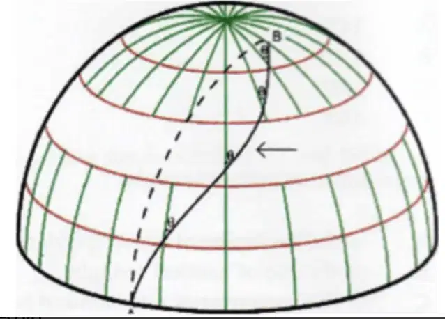
The solid line A to B indicated by the arrow in this diagram is ….
a great circle
a small circle
the equator
a rhumb line
What chart projection is produced by placing a cylinder tangential to the equator?
Lambert's conformal chart
Mercator chart
Mercator polar spheroid
Transverse Lambert’s chart
Transverse Mercator chart
What is the major disadvantage of the Mercator chart?
The chart can only be used at latitudes between 70°N and 70°S
It is not possible to show the equator
Great circles cannot be plotted (because they are curves)
Rhumb lines will appear as straight lines
Can a Lambert chart be used for polar regions?
YES
NO
Which chart projection will show meridians as ‘parallel, straight and equi-distance spaced lines’
Lambert conformal
Mercator
Listed as a principal advantage, which chart is the more useful for representing countries with east/west expanse, e.g. Australia?
Lambert conformal
Mercator
What do blue circles represent on a chart?
CFZ
MBZ
TM
CTR
A thick light blue line on the map will represent two types of airspace:
MBZ, CFZ
CFZ, GAA
GAA, Transit Lane
Transit Lane, CTA

How high can you climb above Forest Field if you want to stay in class G airspace?
1000ft
1500ft
2000ft
2500ft

What does LL 7500 mean?
Upper limit of CTR is 7500ft AGL
Lower limit of CTR is 7500ft AMSL
Upper limit of CTA is 7500ft AGL
Lower limit of CTA is 7500ft AMSL
Which is correct?
All uncontrolled airpsace is TM
If airspace is TM you must have an operable alternator
All controlled airspace is TM
TM stands for Transit Lane Mandatory

What do the numbers circled represent?
Highest Elevation
Lower limit of CTA
Lowest Elevation
Upper limit of CTA

What is the symbol circled?
Water race
Railway
Powerline
Road

What is the symbol circled?
Lit obstacle
Un-lit obstacle
Windmill
Power Station
What is a visual reporting point symbolised by?
A red circle
A white circle with a black line
A blue and green star
A half blue diamond
What are the rules with a MBZ?
You must have an operable radio and transmit position at certain times
You must have an operable transponder and radio and transmit at specified intervals
You should have a radio and transmit but not required by law
You must request approval from ATC before entering
What does a thin light blue line on the chart represent?
GAA
Transit Lane
Low Flying Zone
CTR
What is a CTR represented by on the VFR chart?
Thick light blue line
Dark blue line
Purple line
Dark blue circles
What size scale does a VPC have?
1:100,000
1:250,000
1:500,000
1:1,000,000
How do you write the position of a feature from a chart?
Latitude, Longitude
Longitude, Latitude
Does the 1:1,000,000 chart have a larger or smaller scale than 1:250,000
smaller
larger
From which document can you determine surface type of a runway?
Aeronautical chart
Aerodrome chart
Visual planning chart
AIPNZ Supplements
Where can you find the variation for your area?
Select all that apply.
Aeronautical Chart
Aerodrome Chart
AIPNZ Supplements
NOTAM
How is relief shown on an aeronautical chart?
Colour coding
Isogonals
Flux lines
In writing (feet AMSL)

Does this airfield have a WDI (wind direction indicator)?
No
Yes, 1
Yes, 2
Yes, 3

What does this arrow mean?
Left-hand circuit
Right-hand circuit
Turn early - caution crane
Runway 32 is duty runway
What does a line A-B on an aeronautical chart represent?
True bearing
True heading
Magnetic track
Relative bearing
You want to fly to Wellington (NZWN). Where can you find direction and length of the runway?
NZWN Aeronautical Chart
NZWN Aerodrome Chart
VPC
VNC
When lost how should you re-establish position?
By looking from ground to map
By looking from map to ground
By calling the CFI and asking them to figure it out
By using flight radar
If you have been forced down to a lower altitude you should
Confirm your position more often as you can't see as much and there is less room for error as you are closer to the ground if there was an engine failure
Confirm your position less often as you can't see as much and there is more room for error as you are closer to the ground if there was an engine failure
A waypoint (WPT) is defined as
A location or fix which can be entered into an area navigation system and is primarily published for IFR
A location or fix which can be entered into an area navigation system and is primarily published for VFR
A location or fix which can be plotted into an area navigation system and is primarily published for IFR
A location or fix which can be plotted into an area navigation system and is primarily published for VFR
Define a true bearing
Direct straight line drawn from point A to point B
A line in the G1000 from point A to point B
Indirect line drawn from point A to point B
A line from point A to T.O.A
What is a ground position?
The reference to the aircrafts position on the surface of the earth
The aircrafts position on the surface of the chart
The reference to the aircrafts position over an ATS
The reference of the position we park our aircrafts on the ground
In the instance of flight where you are navigating except for when you are lost how do you navigate?
map to ground
ground to map

