
 Worksheets
Alvirne AFJROTC - Navigation
Total questions: 83
Worksheet time: 47mins
What is the purpose of a topographic map?
To show the locations of cities and towns
To depict the natural and man-made features of the land surface
To provide directions for driving
To illustrate population density
What is a "pace count?"
The number of steps you take in a certain period of time
The number of steps it takes to travel a known distance
The rate of speed at which you walk
The time it takes to walk one mile
What does a "contour line" on a topographic map represent?
Magnetic declination
Elevation above sea level
Latitude
Longitude
What feature do contour lines close together on a topographic map indicate?
A flat area
A steep slope
A body of water
A magnetic field
What is the main line of longitude located at 0 degrees called?
International Date line
Equator
Prime Meridian
Tropic of Capricorn
What is the purpose of a "legend" on a topographic map?
To show the scale of the map
To explain the meaning of symbols and colors used on the map
To indicate the north direction
To list the names of all the landmarks
What does the "scale" of a map tell you?
The elevation of the land
The orientation of the map
The ratio of a distance on the map to the actual distance on the group
The location of water bodies
What is the purpose of the rotating bezel on a baseplate compass?
To store the compass in a compact form
To set the desired direction of travel
To calculate the distance to a specific location
To measure the altitude

Identify A
Crust
Mantle
Outer Core
Inner Core
Identify B
Crust
Mantle
Outer Core
Inner Core
Identify D
Crust
Mantle
Outer Core
Inner Core
Which layer of the earth is completely liquid?
What is primarily responsible for generating the Earth's magnetic field?
The Moon's gravitational pull
The Earth's outer core movement
Solar wind interaction
Earth's crustal composition
What is the shape of Earth's magnetic field?
A perfect circle
A distorted triangle
A dipole (like a bar magnet)
An irregular, undefined shape
What is "declination?"
The difference between grid north and magnetic north
The angle between true north and magnetic north
The distance between two points on a map
The amount of daylight at a specific latitude
Which topographic map feature will help you identify a thick, wooded area?
Contour lines
Vegetation symbols
Road networks
Dark green color
What topographic map color represents man-made features?
Black
Brown
Green
Blue
The zero-degree line of latitude is the ___________.
The zero-degree mark of longitude is commonly known as the ___________ ______________ and runs through Greenwich, England.
What does a topographic map show?
Weather patterns
Elevation and land features
Population density
Road traffic
What do contour lines on a topographic map represent?
Roads
Rivers
Elevation changes
Forests
What does it mean when contour lines are close together?
Flat land
Steep slope
Water body
Valley
What does a blue line on a topographic map represent?
Trail
Road
Fence
River or stream
Which cardinal direction is at the top of a topographic map?
West
South
East
North
What is True North?
The direction of the sun
The direction of the magnetic north pole
The direction of the geographic north pole
The direction of the nearest city
What is magnetic north?
The direction of the geographic north pole
The direction your compass points
The direction of the moon
The direction of the wind
What part of a compass always points to magnetic north?
Red needle
Baseplate
Direction-of-travel arrow
The orienting lines
When holding a compass flat on your hand, where should the direction-of-travel arrow point?
Towards you
To your right
Away from you
To your left
What does "put red in the shed" mean?
Turn your body to align the red needle with the orienting arrow
Put your compass away
Adjust the rotating bezel
Adjust your compass for declination
What does "follow Fred" mean?
Follow the red needle
Follow the sun
Follow the direction-of-travel arrow
Adjust the rotating bezel
How does walking uphill affect your pace count?
Paces are longer
Paces don't change
Paces are shorter
What factors can affect your pace count?
Weather
Terrain
Fatigue
All of the above
What does "East is least" mean when adjusting for declination?
Subtract degrees if declination is east
Add degrees if declination is east
Go east
What does "West is best" mean when adjusting for declination?
Subtract degrees if declination is west
Add degrees if declination is west
Go west
What do lines of latitude measure?
Distance east and west
Distance north and south
Elevation
Declination
Lines of latitude are also called:
Axes
Meridians
Parallels
Equators
What do lines of longitude measure?
Depth
Speed
Distance north and south
Distance east and west
Lines of longitude are also called:
Circles
Meridians
Parallels
Zones
Which of the following is a major terrain feature?
Spur
Hill
Draw
Cliff
What is a valley?
A low area between hills or mountains
A high point
A flat area
A steep slope
Which of the following is a minor terrain feature?
Hill
Valley
Spur
Ridge
How does the Earth's magnetic field protect us?
It keeps the temperature stable
It blocks harmful solar radiation
It helps plants grow
It creates gravity
What is the name of the region where Earth's magnetic field protects us from solar wind?
Atmosphere
LIthosphere
Biosphere
Magnetosphere
How is the Earth's magnetic field useful for navigation?
It powers the Global Positioning System
It controls the weather
It allows compasses to work
Which layer of the Earth is made of molten rock and lies beneath the crust?
Inner core
Outer core
Lithosphere
Mantle
What happens if you use a compass near metal objects or electronics?
It becomes more accurate
It stops working completely
It points to true north
It may give inaccurate readings
What does the red end of the magnetic needle point towards?
True north
The south pole
Magnetic north
East
To set a desired bearing into a compass, you must
Turn your body to face north
Rotate the bezel so the bearing is over the index line
Align the needle with the orienting arrow
Shake the compass to activate the needle
After setting the desire bearing, what is the next step?
Walk in the direction of the red needle
Follow the direction-of-travel arrow
Rotate your body until the red needle is inside the orienting arrow
Which feature on a topographic map indicates elevation changes?
Legend
Scale
Contour lines
Compass rose
What is the purpose of the legend on a topographic map?
To indicate north direction
To explain the symbols used
To show the map's scale
To display elevation
Which direction does a compass needle always point?
West
North
South
East
What does the scale on a map indicate?
The type of terrain
The distance represented on the map compared to real life
The direction of north
The population density
Which feature would you use to determine the steepness of a hill on a topographic map?
Contour interval
Map title
Legend
Grid lines
If contour lines are close together, then the slope is __________.
The height above sea level is called __________.
Waterfall
Steep area
Gentle slope
River
There are ____ degrees on a compass.
90
180
270
360
_____ is 90 degrees on a compass.
North
East
South
West
_____ is 180 degrees on a compass.
North
South
East
West
______ is 270 degrees on a compass.
North
South
East
West
0 degrees longitude is known as the __________.
Optimus Prime
Prime Meridian
North Pole
The difference between true north and magnetic north is called __________.
angle
declination
difference
altitude
On maps, blue stands for ___________.
sky
woods
meadows
water
What part of the map gives you distance on the map?
Key
Legend
Scale
Data frame
What are the cardinal directions?
NW, NE, SW, SE
SE, EW, NW, SW
N, E, S, W
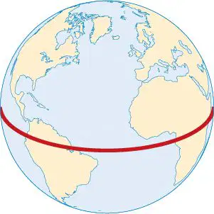
The Equator divides what two hemispheres?
East and West
North and South
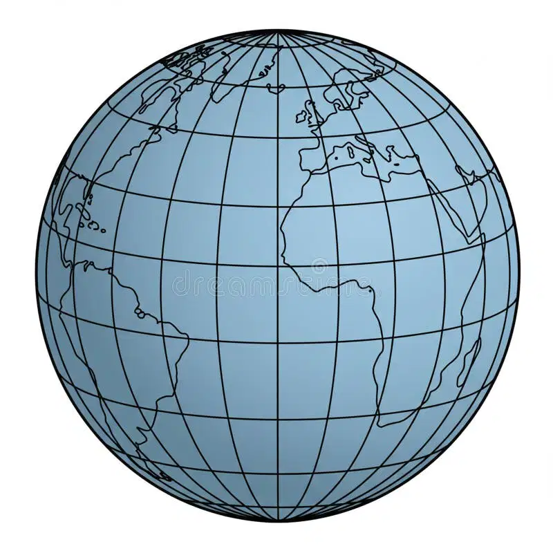
An imaginary line that divides the eastern and western hemispheres?
Equator
longitude
Prime Meridian
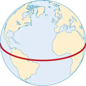
What is the name of this line at 0 degrees latitude?

Which of the following colors on topographic and orienteering maps describe forests with little or no undergrowth that allows for easy passage?
Black
Blue
White
Green
Brown lines on a topographical are called __________.
Rhumb lines
Contour lines
Convergence
Scalar lines
How can you ensure accurate compass readings in the field?
Hold the compass at an angle
Keep the compass away from metal objects and electronics
Use the compass only at night
Always use the compass in a moving vehicle
Man-made features
Man-made features
Man-made features
What is the protective layer around Earth that shields us from harmful space weather?
Exosphere
Troposphere
Magnetosphere
Stratosphere
What generates the magnetic field around the Earth?
The __________ protects us from the sun's harmful radiation and solar wind.
Magnetosphere
Biosphere
Hydrosphere
Heliosphere

