
 Worksheets
Unit 1 Test - Thinking Like a Geographer
Total questions: 20
Worksheet time: 10mins
Name
Class
Date
1.
Every map projection has some degree of distortion because
a)
a curved surface cannot be represented on a flat surface without distortion
b)
latitude and longitude never cross at right angles on a globe
c)
maps are 3D but the Earth is 2D
d)
a sphere is a developable surface
2.
A computer system that stores, organizes, retrieves, analyzes, and displays geographic data in layers is
a)
GPS
b)
GIS
c)
remote sensing
d)
USGS
3.
If you wanted to see the location of the city building in Seattle, Washington, you would use a
a)
topographic map
b)
reference map
c)
graduated symbol map
d)
cartogram
4.
The acquisition of data about Earth's surface from a satellite, spacecraft, or specially equipped high-altitude balloon is
a)
GIS
b)
GPS
c)
remote sensing
d)
USGS
5.
Which term describes the location of a geographic feature in relation to other features?
a)
absolute location
b)
hemisphere
c)
relative location
d)
map projection
6.
Which term is used to describe the exact place on Earth at which a geographic feature is found?
a)
absolute location
b)
hemisphere
c)
relative location
d)
map projection
7.
Which of the following is NOT a characteristic of place?
a)
Places change over time.
b)
Places interact with and relate to other places.
c)
Places have physical and cultural features.
d)
Places cannot be grouped into regions.
8.
What is the name given to a place, the easiest way to describe a location?
a)
absolute location
b)
site
c)
situation
d)
toponym
9.
A collection of places that are grouped together on the basis of one or more unifying characteristics is known as a
a)
region
b)
site
c)
situation
d)
relative location
10.
Which of the following is NOT true of a region?
a)
Tension is possible within a region.
b)
Regions do not change over time.
c)
Regions are united through the cultural landscape.
d)
Regions are separated by a transition zone.
11.
There are no negative consequences for modifying the environment.
a)
True
b)
False
12.
What are natural resources essential for?
a)
Human survival
b)
Entertainment
c)
Fashion
d)
Social Media
13.
What resource is the backbone of our modern world, providing energy for homes, industries, and transportation systems?
a)
solar power
b)
hydroelectric power
c)
wind energy
d)
fossil fuels
14.
Why do people in warm areas like Egypt wear light clothes?
a)
To protect from the cold
b)
To follow fashion trends
c)
To keep cool in warm climates
d)
To attract attention
15.

What type of region is depicted in the map?
a)
formal
b)
functional
c)
perceptual
16.

What type of region is depicted in the map?
a)
formal
b)
functional
c)
perceptual
17.
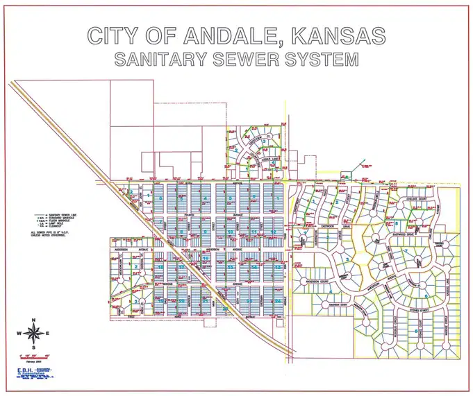
What type of region is depicted in the map?
a)
formal
b)
functional
c)
perceptual
18.
How do maps help geographers? Why are maps considered a geographer's greatest tool?
a)
Maps are considered a geographer's greatest tool because they visually represent spatial information, enabling analysis and communication of geographical data.
b)
Maps are outdated and have no relevance in modern geography.
c)
Geographers rely solely on satellite images instead of maps.
d)
Maps are only useful for navigation purposes.
19.
How do geospatial technologies help geographers solve "real world" problems?
a)
Geospatial technologies only provide visual maps without analysis.
b)
Geospatial technologies are primarily used for entertainment purposes.
c)
Geospatial technologies help geographers analyze spatial data to solve real-world problems.
d)
Geospatial technologies have no impact on environmental studies.
20.
What is the impact of humans modifying their environment?
a)
Improved water conservation
b)
Enhanced air quality
c)
The impact includes habitat destruction, climate change, loss of biodiversity, and creation of new ecosystems.
d)
Increased agricultural productivity
100 %

