wayground logo

Free Printable Worksheets

NEW

Font size

S
M
L
XL
Worksheets

Regents Earth Science Weather and Climate

Total questions: 48

Worksheet time: 59mins

Name
Class
Date
1.
Air always blows from 
a)
a. High pressure to low pressure
b)
b. Hot air to cold air
c)
c. low pressure to high pressure
d)
d. East to west
2.
Winds in the Northern hemisphere curve to the 
a)
upward
b)
downward
c)
left
d)
right
3.
Which direction do winds blow between 30°N and 60°S
a)
from the NW
b)
from the SE
c)
from the SW
d)
from the NE
4.
What causes wind?
a)
differences in pressure
b)
differences in oxygen
c)
differences in thermosphere
d)
differences in gravity
5.
What causes differences in air pressure around the Earth?
a)
warm air rises at the equator and warm air sinks at the poles
b)
cold air sinks at the equator and warm air rises at the poles
c)
warm air rises at the equator and cold air sinks at the poles
d)
cold air sinks at the equator and cold air rises at the poles
6.
What is B?
a)
Evaporation
b)
Condensation
c)
Precipitation
d)
Runoff
7.

How does the temperature and precipitation on the windward side of the mountain compare to the temperature on the leeward side?

a)

Temperature on the leeward side is cooler and there is more precipitation.

b)

Temperature and precipitation on the leeward side is the same as the windward side.

c)

Temperature on the windward side is cooler and there is more precipitation.

d)

Temperature on the windward side is warmer and there is less precipitation.

8.
Why is the climate warmer in the tropics than at the South Pole?
a)
The South Pole receives less intense insolation.
b)
The South Pole receives more infrared radiation.
c)
The South pole is a lower elevation.
d)
The South Pole has more cloud cover.
9.
Which climatic factor likely explains why you observe snowfall in the diagram on top of the mountains?
a)
 ocean currents
b)
latitude
c)
elevation
d)
 global winds
10.
Warm air masses that form near the equator over water are called
a)
maritime tropical air masses
b)
maritime polar air masses
c)
continental polar air masses
d)
continental tropical air masses
continental air masses
11.
Maritime polar air masses are
a)
dry and cold
b)
humid and cold
c)
humid and warm
d)
dry and warm
12.
Which side of a mountain range has a higher humidity?
a)
leeward
b)
windward
c)
rainshadow
d)
eastside
13.
Cities closer to water most likely will have
a)
warmer summers and cooler winters
b)
cooler summers and warmer winters
c)
cooler summers and winters
d)
warmer summers and winters
14.
Several factors affect climate.  ________ determines the amount of solar energy received, and the prevailing wind belts.
a)
longitude
b)
elevation
c)
latitude
d)
topography
15.
Air masses that are characteristically cool and dry
a)
cP
b)
cT
c)
mP
d)
mT
16.
Fronts are classified according to the ______________ of the air mass behind the front.
a)
temperature
b)
precipitation type
c)
moisture content
d)
wind speed
17.
What forms at the boundary between two different air masses with different properties?
a)
a front 
b)
a hurricane eye wall 
c)
 a storm surge 
d)
a tornado 
18.
What type of front is this?
a)
warm front
b)
cold front
c)
stationary front
d)
occluded front
19.
What type of front is this?
a)
warm front
b)
cold front
c)
stationary front
d)
occluded front
20.
What type of front is this?
a)
warm front
b)
cold front
c)
stationary front
d)
occluded front
21.
Identify the type of front that is represented in this cross section.
a)
Occluded Front
b)
Cold Front
c)
Stationary Front
d)
Warm Front
22.
Identify the type of front that is represented in this cross section.
a)
Occluded Front
b)
Cold Front
c)
Stationary Front
d)
Warm Front
23.
What type of of air mass is moist and warm?
a)
mP
b)
mT
c)
cT
d)
cP
24.
Cold, dry air originating from Canada is _________.
a)
continental tropical
b)
continental polar
c)
maritime tropical
d)
maritime polar
25.
Warm, moist air originating from the Gulf of Mexico is _________.
a)
continental tropical
b)
continental polar
c)
maritime tropical
d)
maritime polar
26.
Why does this city experience a small range of temperatures from summer to winter?
a)
It is near a mountain range.
b)
It is near the equator.
c)
It is near a frontal boundary
d)
It is near a large body of water.
27.
Due to the orographic effect, the leeward side of the mountains
a)
receives heavy rain or snowfall because of prevailing winds
b)
is dry because of the rain shadow effect
c)
is dry because of prevailing winds
d)
forces clouds to rise, cool, and drop all of their moisture
28.
As you go to the top of a mountain, what happens to temperature?
a)
Nothing
b)
It increases
c)
It decreases
d)
It goes up and down
29.
Due to the Coriolis Effect, water in the northern hemisphere moves
a)
clockwise
b)
counter clockwise
c)
both
d)
neither
30.
The Coriolis Effect is caused by
a)
Earth rotating around the sun
b)
Earth rotating on its axis
c)
The tides
d)
Gravity
31.
Cold ocean currents generally come from
a)
The North Pole 
b)
The South Pole
c)
The Equator
d)
Either Pole
32.
The Gulf stream carries _____________ water from the east coast of The United States to the West coast of Europe.
a)
Cold
b)
Warm 
c)
Freezing
d)
Fresh
33.
The California Current (west coast) carries _________ water from canada
a)
Cold 
b)
Warm
c)
Freezing
d)
Fresh
34.
The effect of Earth’s rotation on the direction of winds and currents is called the _______________ .
a)
La Niña
b)
 El Niño
c)
Coriolis effect
d)
Currents
35.
What hemisphere is the location of this climatograph most likely in?
a)
Northern Hemisphere
b)
Southern Hemisphere
c)
It is not possible to tell
d)
Neither; this is on the equator
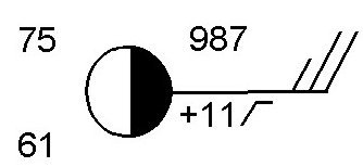
36.
What is the temperature at this station
a)
75 degrees
b)
61 degrees
c)
987 degrees
d)
11 degrees
37.
What is the dew point at this station?
a)
75 degrees
b)
61 degrees
c)
987 degrees
d)
11 degrees
38.
What is the wind direction at this station?
a)
Wind is blowing from the north
b)
Wind is blowing to the East
c)
Wind is blowing from the East
d)
Wind is blowing to the North
39.

3) Which station model represents a location that has the greatest chance of precipitation?

a)
b)
c)
d)
40.

19) What is the visibility, in miles, shown on the station model below?

a)

10

b)

28

c)

38

d)

57

41.
What is the barometric pressure?
a)
18
b)
19
c)
147
d)
-13
42.

What is the atmospheric pressure at this station?

a)

987 mb

b)

998.7 mb

c)

1098.7 mb

d)

987.0 mb

43.
Which weather tool measures air pressure?
a)
thermometer
b)
barometer
c)
anemometer
d)
psychrometer
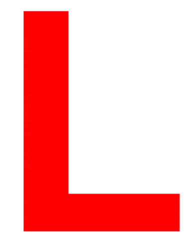
44.
What does this symbol on a weather map indicate? 
a)
High pressure system
b)
Low pressure system
c)
Cold front
d)
Warm front
45.
A _____ is a large, swirling, low-pressure system that forms over the Atlantic Ocean.
a)
blizzard
b)
cold front
c)
tornado 
d)
hurricane
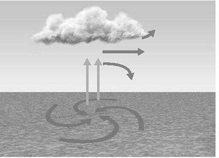
46.
Which type of pressure system is pictured?
a)
high
b)
low
c)
medium
d)
none
47.
What type of weather would you expect with the pressure system pictured?
a)
clear
b)
cloudy
c)
severe storms
d)
hot
48.

Closely spaced isobars indicate a __________ pressure gradient and __________ winds.

a)

weak; high

b)

weak; low

c)

steep; high

d)

steep; low