
 Worksheets
Part 107 NAS Review
Total questions: 99
Worksheet time: 50mins
What does the acronym NAS stand for in aviation?
National Airspace System
National Aeronautics Society
National Aviation Service
National Aircraft System
Which classes of airspace are considered controlled airspace?
Class A, B, C, D, and E
Class G only
Class F and G
Class B, D, and G
What is the primary purpose of the Chart Supplement U.S.?
To provide key information about airports, seaplane bases, heliports, and navigational facilities
To list all aircraft manufacturers
To provide weather forecasts
To display only military airspace
Which type of airspace is Class G airspace referred to as?
Uncontrolled airspace
Controlled airspace
Restricted airspace
Prohibited airspace
Why is it necessary for a remote PIC to check NOTAMs before each flight?
To determine if there are any applicable airspace restrictions
To check the weather forecast
To find out about new aircraft models
To review pilot training schedules
What is the scale of the Sectional Aeronautical Chart most commonly used by manned pilots?
1:500,000
1:250,000
1:100,000
1:1,000,000
How often is the Chart Supplement U.S. reissued in its entirety?
Every 56 days
Every 30 days
Every 12 months
Every 7 days
What is the main difference between the Sectional Aeronautical Chart and the Terminal Area Chart (TAC)?
TAC shows more significant detail but has smaller area coverage
Sectional Chart is only for military use
TAC is only for international flights
Sectional Chart is not updated regularly
Which of the following is NOT a category of NOTAM information?
Weather NOTAMs
NOTAM (D) or distant
Flight Data Center (FDC) NOTAMs
Special Activity Airspace (SAA) NOTAMs
Which type of NOTAM is issued by the National Flight Data Center (NFDC) and contains regulatory information such as temporary flight restrictions?
Military NOTAM
FDC NOTAM
Pointer NOTAM
SAA NOTAM
What is the main purpose of a Pointer NOTAM?
To designate temporary flight restrictions
To highlight or point out another NOTAM
To provide weather reports
To issue military airspace information
Which of the following is NOT a common type of Temporary Flight Restriction (TFR) related to sUAS operations?
Presidential TFRs
Emergency response TFRs
Standing TFRs for sporting events
Commercial airline TFRs
Where can TFRs also be found online?
faa.gov
tfr.faa.gov
aim.faa.gov
notam.faa.gov
What is the purpose of Advisory Circulars (ACs) issued by the FAA?
To provide regulatory requirements
To inform the aviation community of non-regulatory material of interest
To issue temporary flight restrictions
To publish NOTAMs
Why is it important for sUAS remote PICs to be aware of the type of airspace in which they will be operating?
To avoid weather changes
To ensure compliance with airspace restrictions
To increase flight speed
To reduce fuel consumption
Which publication is the official guide to basic flight information and ATC procedures, issued yearly with ongoing revisions?
AC
AIM
NOTAM
TFR
If a remote PIC is planning a flight near a stadium during a major sporting event, which type of NOTAM or TFR should they check for?
Presidential TFR
Emergency response TFR
Standing TFR
Military NOTAM
A remote PIC is preparing for a flight and finds both a Pointer NOTAM and an FDC NOTAM for the area. How should the PIC use this information to ensure a safe and legal flight?
Ignore both NOTAMs as they are not relevant
Only check the FDC NOTAM for restrictions
Use the Pointer NOTAM to find additional relevant NOTAMs and review the FDC NOTAM for regulatory restrictions
Only check the Pointer NOTAM for information
Which classes of airspace are considered controlled airspace where sUAS operations require prior authorization from ATC?
Class B, Class C, and Class D only
Class G and Class E only
Class B, Class C, Class D, and within the lateral boundaries of the surface area of Class E designated for an airport
Class F and Class G only
What must a remote PIC do before operating a sUAS in controlled airspace?
Obtain prior authorization from ATC
Notify local law enforcement
File a flight plan with the FAA
Request permission from the airport manager
According to the text, what is the primary reason for the FAA to approve or deny aircraft operations in controlled airspace?
The type of sUAS being used
The operational parameters and potential impact on the safe and expeditious flow of air traffic
The weather conditions
The time of day
How are the lateral limits and floors of Class E airspace of 700 feet defined on a Sectional Chart?
By a green vignette
By a magenta vignette (shading)
By a red dashed line
By a yellow border
Why is it important for a remote PIC to refer to current aeronautical charts and navigation tools before sUAS operations?
To determine the weather forecast
To determine position and related airspace
To find the nearest gas station
To check for wildlife in the area
A remote PIC is planning to operate a sUAS in Class G airspace. What is required before conducting the operation?
Prior authorization from ATC
No further permission or authorization is required
Filing a flight plan with the FAA
Approval from the local government
If the floor of controlled airspace is other than 700 feet or 1,200 feet, how is it indicated on a Sectional Chart?
By a blue vignette
By a number indicating the floor
By a red circle
By a green dashed line
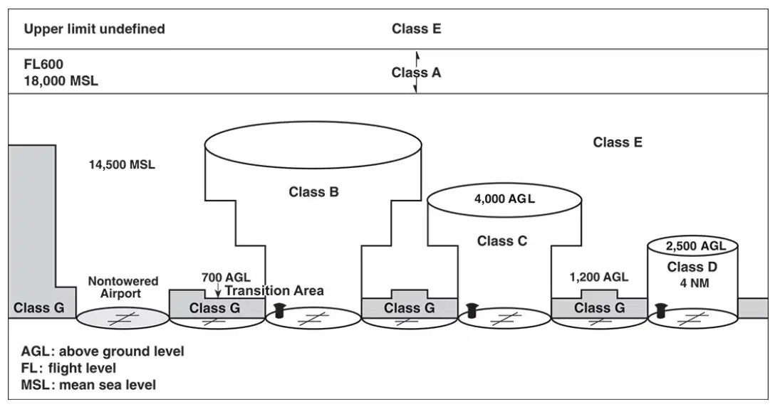
Which class of airspace extends from 18,000 feet MSL up to and including flight level (FL) 600 (60,000 feet)?
Class A
Class B
Class C
Class D
What is required before operating within Class B airspace?
ATC clearance
No clearance required
Only a radio call
Visual flight rules only
On aeronautical charts, how is Class B airspace depicted?
Outlined in blue with delimiting arcs, radials, and altitudes
Outlined in red with dashed lines
Outlined in green with solid lines
Outlined in black with dotted lines
Which of the following statements best describes the structure of Class C airspace?
Two circles centered on the primary airport, with an inner area of 5 NM radius and an outer shelf of 10 NM radius
A single cylinder extending from the surface to 18,000 feet
A rectangular area extending 20 NM from the airport
A triangular area with no vertical limits
Why might some large, busy airports designated as Class B Primary airports require a pilot to hold at least a Private Pilot Certificate?
Due to additional operating requirements or limitations
Because of the lack of ATC services
To allow for glider operations
To reduce noise pollution
If a pilot is flying in the outer area of Class C airspace, what is encouraged but not required?
Participation in two-way radio communication with ATC
Filing a flight plan
Flying above 10,000 feet
Using only visual navigation
What is the typical vertical extent of Class D airspace above ground level (AGL)?
Up to 2,500 feet AGL
Up to 14,500 feet AGL
Up to 700 feet AGL
Up to 60,000 feet AGL
Which color is used on Sectional Charts to identify Class E airspace starting at 700 feet AGL?
Blue shading
Magenta shading
Green shading
Red shading
What distinguishes Class G airspace from other classes of airspace?
It is controlled by ATC at all times
It has no ATC authority or responsibility for air traffic control
It is only used for military operations
It requires a transponder at all times
Why might entry into a Restricted Area be hazardous to aircraft and occupants?
Due to high commercial air traffic
Due to the presence of unusual, often invisible, hazards such as artillery firing or guided missiles
Due to frequent weather changes
Due to low visibility only
What is the primary purpose of Military Operations Areas (MOAs)?
To separate commercial flights from private flights
To separate certain military training activities from IFR traffic
To provide airspace for agricultural aviation
To restrict all civilian flights
A pilot is flying through an Alert Area. What should they be particularly aware of?
High volume of pilot training activities or unusual aerial activity
Severe weather conditions
High mountain terrain
International border crossing
If a pilot wants to enter a Restricted Area, what must they do according to regulations?
Enter without any permission
Obtain authorization from the using or controlling agency
Only notify ATC after entering
File a flight plan only
Which of the following is true about Prohibited Areas?
Aircraft may enter with ATC clearance
Flight of aircraft is prohibited within these areas
Only military aircraft are prohibited
Only helicopters are allowed
How is a Class E airway depicted on a sectional chart?
By a magenta dashed line
By a blue dashed line
By a centerline, shown in blue
By a green solid line
What is a key difference between Warning Areas and Restricted Areas?
Warning Areas are only over land
Warning Areas are located in international airspace, while Restricted Areas are not
Restricted Areas are always open to civilian traffic
Warning Areas have no hazards
What is the primary purpose of Military Training Routes (MTRs)?
To conduct low-altitude, high-speed military training
To provide commercial airline routes
To designate international airspace boundaries
To mark areas for agricultural aviation
Which of the following best describes how IFR Military Training Route (IR) operations are conducted?
In accordance with instrument flight rules, regardless of weather conditions
Only during clear weather conditions
With visual flight rules only
At altitudes above 10,000 feet MSL
How are VFR Military Training Routes (VR) at and below 1,500 feet AGL identified?
By four digit numbers
By three digit numbers
By color codes
By airport codes
According to Advisory Circular 91-36, what is the minimum distance aircraft are requested to remain above the surface of National Parks and similar areas?
2,000 feet
1,000 feet
500 feet
3,000 feet
Which of the following is NOT considered a noise-sensitive area as defined by Advisory Circular 91-36?
Urban city centers
National Parks
National Monuments
National Wildlife Refuges
What is the function of a Local Airport Advisory (LAA) service?
To provide advisory service at airports using a discrete ground-to-air frequency or the tower frequency when the tower is closed
To control all air traffic in the region
To provide weather forecasts for pilots only
To issue pilot licenses
When is ATC authorization required for remote pilots?
At or near an airport with a control tower and/or when operating within controlled airspace
Only when flying above 10,000 feet
When flying over water bodies
When operating in rural areas
What should remote pilots do when ATC authorization is not required?
Monitor the Common Traffic Advisory Frequency (CTAF) of any nearby airport(s)
Ignore all communications
Contact the Department of Defense
Only fly during daylight hours
Why is it important for remote pilots to contact the appropriate ATC facility as soon as possible prior to any operation in Class B, C, and D airspace?
Because approval depends on traffic density, controller workload, and safety issues
Because it is required for all types of airspace
Because it is only necessary for international flights
Because it guarantees immediate approval
A remote pilot is planning to operate near a National Wildlife Refuge at 1,800 feet AGL. What considerations should the pilot take into account based on the provided information?
The pilot should remain at least 2,000 feet above the surface and be aware of the lateral boundaries of the area to minimize noise impact.
The pilot can fly at any altitude as long as the weather is clear.
The pilot only needs to contact the local airport advisory service.
The pilot should only be concerned with visual flight rules.
What is the name of the imaginary circle that is equidistant from the poles and runs around the earth?
Prime Meridian
Equator
Longitude
Tropic of Cancer
Which lines run east and west, parallel to the equator, and are used to measure angular distance north or south of the equator?
Meridians of longitude
Parallels of latitude
Prime meridians
Contour lines
What is the angular distance from the equator to either pole?
45°
60°
90°
180°
Where does the prime meridian pass through?
Paris, France
New York, USA
Greenwich, England
Tokyo, Japan
How are measurements made from the prime meridian?
Only easterly up to 90°
Only westerly up to 90°
Both easterly and westerly up to 180°
Both easterly and westerly up to 90°
A location is given as 39°N 77°W. What does the 'N' and 'W' indicate in this coordinate?
North latitude and West longitude
North longitude and West latitude
North latitude and West latitude
North longitude and West longitude
What is a Sectional Chart used for?
To measure temperature changes
To show topographical information of a portion of the Earth's surface
To calculate time zones
To display ocean currents
Why should remote pilots become familiar with Sectional Chart Legends?
To understand weather patterns
To interpret all topographical information and symbols on the chart
To calculate distances between cities
To find population data
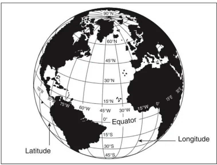
What does the diagram in Figure 2-2 illustrate?
The distribution of continents
Meridians of longitude and parallels of latitude
The Earth's magnetic field
Ocean currents
How is each degree (°) further subdivided to describe a location more precisely?
Into 100 minutes and 100 seconds
Into 60 minutes and 60 seconds
Into 10 minutes and 10 seconds
Into 30 minutes and 30 seconds
What must a remote PIC do when operating in the vicinity of an airport?
Ignore all other aircraft
Yield right-of-way to all other aircraft
Only follow the runway lights
Land immediately
Which of the following is a source for airport data that remote PICs should consult?
The Weather Channel
The Chart Supplement U.S.
The local newspaper
The airport gift shop
Why are ATC towers established at airports?
To provide food services to pilots
To promote the safe, orderly, and expeditious flow of air traffic
To sell tickets to passengers
To manage airport parking lots
A small unmanned aircraft (sUA) hovering 200 feet above a runway may cause which of the following?
Faster takeoff for manned aircraft
Delay in takeoff or landing for manned aircraft
No effect on airport operations
Increased fuel efficiency for manned aircraft
What is the main reason remote PICs are prohibited from operating their sUA in a manner that interferes with airport traffic patterns?
It increases airport revenue
It may present a potential conflict or affect the safe outcome of a flight
It makes the airport busier
It helps pilots practice emergency procedures
If a remote PIC observes a manned aircraft on the downwind leg of the traffic pattern, what should the remote PIC do?
Ignore the manned aircraft
Yield right-of-way and avoid interfering with the traffic pattern
Attempt to land before the manned aircraft
Request priority from ATC
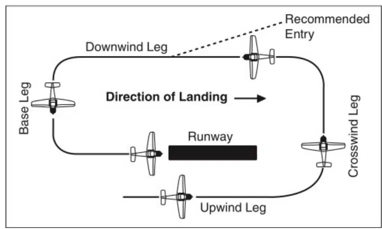
Which of the following is the correct sequence of legs in a standard manned aircraft traffic pattern as shown in the diagram?
Upwind Leg, Crosswind Leg, Downwind Leg, Base Leg, Final
Downwind Leg, Upwind Leg, Base Leg, Crosswind Leg, Final
Crosswind Leg, Downwind Leg, Base Leg, Upwind Leg, Final
Base Leg, Downwind Leg, Upwind Leg, Crosswind Leg, Final
According to the text, what should remote PICs do to avoid interfering with manned aircraft operations in a traffic pattern?
Operate in the traffic pattern at all times
Avoid operating in the traffic pattern or published approach corridors used by manned aircraft
Fly at higher altitudes than manned aircraft
Ignore the presence of manned aircraft
What is the main reason the FAA may approve or deny aircraft operations near airports?
To increase the number of flights
To reduce fuel consumption
To ensure safe and expeditious flow of air traffic
To promote private aviation
When is ATC authorization required for remote PICs operating near airports?
Only when flying at night
When operating at or near an airport with a control tower and/or within controlled airspace
When flying below 400 feet
Only during emergency situations
Why is it advisable for remote PICs to announce their sUAS activity on the CTAF when ATC authorization is not required?
To avoid paying fees
To make manned pilots aware of such operations for safety
To increase air traffic
To request weather updates
What is a Letter of Agreement (LOA) used for in the context of sUAS operations?
To purchase new aircraft
To establish prior authorization for recurring or long-term operations with the controlling ATC facility
To request weather information
To report lost drones
What does SIDA stand for in the context of airport security?
Security Identification Display Area
Special Identification Display Area
Security Identification Designated Area
Special Identification Designated Area
Which of the following is required for individuals in a Security Identification Display Area (SIDA)?
Display an airport-issued or approved identification
Wear a reflective vest at all times
Carry a pilot’s license
Submit a flight plan
How are runway numbers determined at airports?
By rounding the magnetic heading of the runway to the nearest 10°
By the length of the runway in meters
By the number of flights per day
By the airport’s elevation above sea level
If a runway has a magnetic azimuth of 076°, what would its runway number be?
8
7
18
76
Why might a runway have a letter such as L, R, or C after its number?
To differentiate between left, right, or center runways facing the same direction
To indicate the length of the runway
To show the runway’s surface type
To identify the airport’s location
A remote pilot should be familiar with airport markings and signs primarily to:
Exercise vigilant collision avoidance and not interfere with manned aircraft operations
Increase the speed of their aircraft
Reduce fuel consumption
Improve communication with air traffic control
Suppose a runway is facing an azimuth of 183°. What would be its runway number?
18
19
8
1
What is the designated beginning of the runway that is available and suitable for the landing of aircraft called?
The threshold
The apron
The taxiway
The displaced area
Which of the following best describes a displaced threshold?
The end of the runway used for takeoff only
A threshold not at the beginning of the full-strength runway pavement
The area where aircraft park
The centerline of the runway
What is the purpose of the paved area behind a displaced threshold?
It is used for parking aircraft
It is available for taxiing, takeoff, and landing rollout, but not for landing
It is used for emergency landings only
It is reserved for maintenance vehicles
Why is a displaced threshold usually implemented on a runway?
To increase the length of the runway for takeoff
Because of an obstruction in the approach path
To allow more aircraft to land simultaneously
To mark the end of the runway
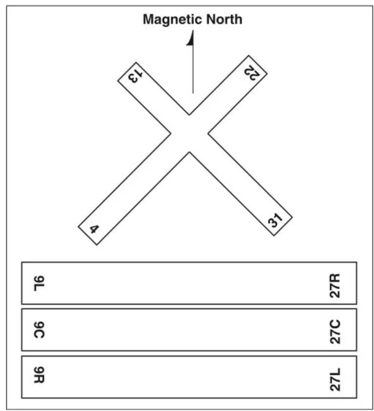
What do the numbers and letters on the runways represent?
The length of the runway in meters
The magnetic heading and position of the runway
The number of aircraft that can land at once
The altitude of the runway
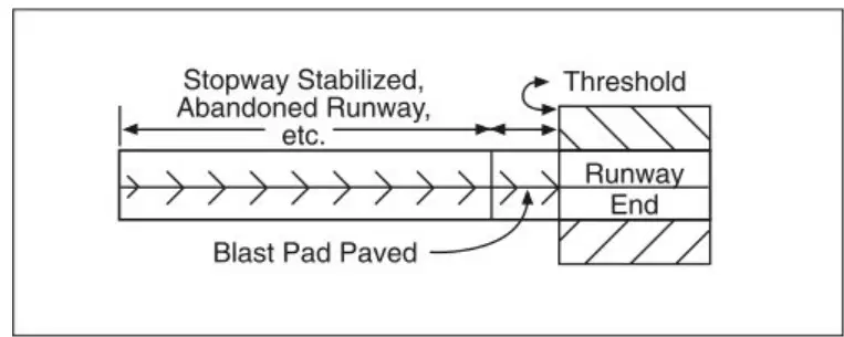
What is the purpose of chevrons marked on certain areas extending beyond usable runways?
They indicate areas suitable for landing.
They mark areas suitable only as overrun areas.
They show where aircraft should begin takeoff.
They indicate the location of taxiways.
What marking is used to indicate a closed runway that may appear usable but is actually hazardous?
A circle
A chevron
An "X"
A triangle
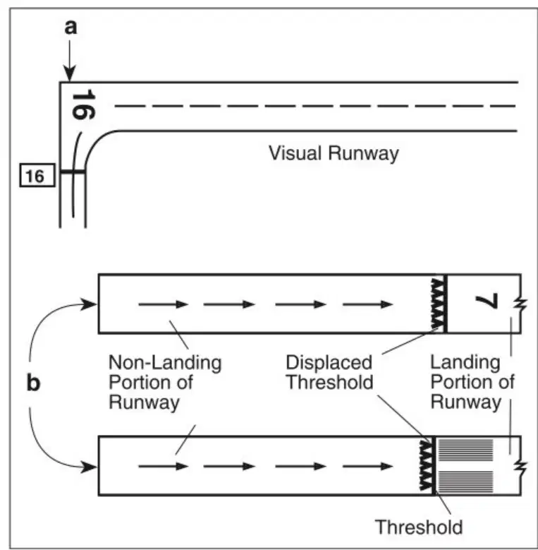
According to the diagrams, what is the function of a displaced threshold on a runway?
It marks the end of the runway.
It designates an area for taxiing only.
It separates the non-landing portion from the landing portion of the runway.
It indicates a closed runway.
Why are stopways not suitable for normal landing or takeoff operations, even though they may appear usable?
They are too short for aircraft to use.
They are only designed for use as overrun areas in emergencies.
They are reserved for maintenance vehicles.
They are used for parking aircraft.
If a pilot sees an "X" marking on a runway, what should they infer?
The runway is open for use.
The runway is under construction but still usable.
The runway is closed and may be hazardous.
The runway is reserved for emergency landings only.
What markings might a basic runway have?
Only centerline markings and runway numbers
Only edge markings and runway numbers
Only stop bars and clearance bar lights
Only taxiway edge markings and position markings
How are taxiways identified?
By a continuous yellow centerline stripe
By a continuous white edge stripe
By red and white dashed lines
By blue lights only
What is the purpose of a holding position marker on a taxiway approaching a runway?
To indicate where aircraft must stop before entering the runway
To show the direction of the wind
To mark the location of the terminal
To indicate the end of the taxiway
Which of the following best describes the composition of a holding position marker?
Four yellow lines: two solid and two dashed
Four white lines: all solid
Two yellow lines: both dashed
Three red lines: two solid and one dashed

What information does Figure 2-7 provide?
Selected airport markings and surface lighting
Weather patterns at airports
Aircraft types and their capacities
Airport terminal layouts
Which type of airport sign has a red background with white inscription and denotes an entrance to a runway, critical area, or prohibited area?
Mandatory instruction sign
Location sign
Direction sign
Information sign
What is the primary purpose of location signs at airports?
To identify a taxiway or runway location, boundary, or ILS critical area
To provide information on areas not visible from the control tower
To indicate the direction of intersecting taxiways
To show the remaining runway distance in thousands of feet
Which airport sign has a yellow background with black inscription and identifies the designation of intersecting taxiways leading out of an intersection?
Direction sign
Destination sign
Runway distance remaining sign
Mandatory instruction sign
What information do runway distance remaining signs provide to pilots?
The distance of the remaining runway in thousands of feet
The location of taxiways and runways
The direction to terminals and cargo areas
The boundaries of critical areas

