
 Worksheets
Unit 1 & 2
Total questions: 37
Worksheet time: 23mins
Cities in Texas are often located near which geographical features that provide transportation and other benefits?
Mountains
Waterways
Deserts
Forests
Why are many major cities in Texas found near rivers, lakes, or the Gulf of Mexico?
Because these locations provide transportation and other benefits.
Because these locations are far from natural resources.
Because these locations have the highest mountains.
Because these locations are the coldest in Texas.
The era of Natural Texas and Its People is defined by what?
American Indian tribes living in Texas and adapting to the environment.
The arrival of European explorers in Texas.
The establishment of Spanish missions in Texas.
The development of oil and gas industries in Texas.
During the era of Natural Texas and Its People, what did tribes develop based on the region's physical environment?
Their own cultures, traditions, and ways of life.
A single, unified government for all tribes.
Advanced industrial technology.
Permanent stone cities.
Historians divide periods of time into eras to organize information about the past.
True
False
Eras help historians understand and analyze the characteristics of a particular time period.
True
False
Which tribe lived in East Texas, in the Gulf Coastal Plains region?
Caddo
Comanche
Jumano
Karankawa
Which tribe was similar to the Karankawa and were nomads along the Gulf Coast?
Coahuiltecan
Caddo
Jumano
Comanche
The Karankawa tribe lived along the Gulf Coast and were also nomads.
True
False
The Jumano tribe lived in which region?
Great Plains
Mountain and Basin Region
Gulf Coastal Plains
Coastal Plain
The Comanches lived in the Great Plains region.
True
False
Coastal Texas has a lower elevation and is near the ocean, while the Mountain and Basin Region has a higher elevation and a different climate.
True
False
When traveling from east to west across Texas, what happens to elevation?
Elevation increases.
Elevation decreases.
Elevation stays the same.
Elevation fluctuates randomly.
Historians use eras to organize changes over time that have occurred in Texas.
True
False
Which of the following eras is Texas history began most recently?
A Contemporary Texas
Age of Contact
Spanish Colonial
Age of Oil
A natural region is an area with a common physical environment.
True
False
Both the Great Plains and Coastal Plains regions have flat land suitable for what?
Farming or ranching.
Skiing and snowboarding.
Deep sea fishing.
Mountain climbing.
A primary source that would help historians understand the four natural regions in Texas would be someone who has lived in all four regions, such as what?
An agricultural worker.
A tourist visiting Texas.
A historian from another state.
A student reading about Texas.
The most recent era in Texas history is called what?
Contemporary Texas.
Reconstruction Era.
Republic of Texas.
Spanish Texas.
The center of the Texas and U.S. oil-refining industries is located in which region?
The Gulf Coast Plain sub-region of the Coastal Plains, between Beaumont and Houston.
The High Plains region near Amarillo.
The Hill Country region around Austin.
The Trans-Pecos region in West Texas.


Which region on the map is shown in red?
Mountains and Basins
Great Plains
Central Plains
Coastal Plains

Which region on the map is identified in green?
Central Plains
Great Plains
Coastal Plains
Mountains and Basins

What are Texas' major cities all near?
Rivers and Coastlines
Mexico
State borders
Food and Clothes

Red River
Guadalupe River
Rio Grande
Trinity River

Neches River
Brazos River
Sabine River
Red River

In what region would you find Houston?
Mountains and Basins
Great Plains
North Central Plains
Coastal Plains
In what region would you most likely find the highest point in Texas, Guadalupe Peak?
Mountains and Basins
Great Plains
North Central Plains
Coastal Plains

What city is represented by #3?
Amarillo
Lubbock
Dallas
El Paso
What city is represented by #5?
Houston
Laredo
El Paso
San Antonio
What city is represented by #6?
Houston
Laredo
El Paso
San Antonio
What city is represented by #7?
Houston
Galveston
El Paso
San Antonio
What changes happen in the physical geography of Texas when you travel from the east to the west?
The elevation rises (increases)
The elevation goes down (decreases)
Texas only has prairies.
There is a lot of trees.
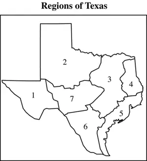
Which region is Big Bend National Park located?
2
4
1
3
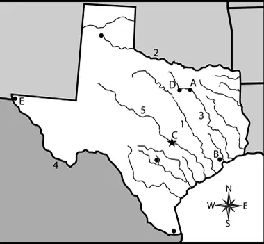
Where is the San Jacinto Monument located?
A
D
C
B

