
NEW
Font size
 Worksheets
Unit 1 Review Quiz Part 1
Total questions: 68
Worksheet time: 34mins
What is the definition of geography?
The study of Earth and its peoples, places, and environments
The study of stars and planets
The study of ancient civilizations
The study of human anatomy
What is the definition of relative location?
The exact location of something
Where a place is compared to another place
The distance between two points
The altitude of a place
Which of the following is an example of absolute location?
My house is north of the park.
The library is next to the school.
KCISLK is 25.0736° north and 121.3910° east.
The store is across from the bank.
What does absolute location refer to?
The general area of a place
The exact location of something
The relative position of a place
The direction from one place to another
Which statement is an example of relative location?
The Eiffel Tower is at 48.8584° N, 2.2945° E.
The school is 2 miles from the library.
The coordinates of the park are 40.7128° N, 74.0060° W.
The museum is located at 51.5074° N, 0.1278° W.
What is the line called that divides the Earth into the Northern and Southern Hemispheres?
Longitude
Latitude
Equator
Prime Meridian
Which line on a map runs from the North Pole to the South Pole?
Equator
Latitude
Longitude
Prime Meridian
What is the name of the line that is at 0 degrees longitude?
Equator
Prime Meridian
Latitude
Tropic of Cancer
Which lines on a map are parallel to the Equator?
Longitude
Latitude
Prime Meridian
International Date Line
Which hemisphere is located above the equator?
Southern Hemisphere
Northern Hemisphere
Eastern Hemisphere
Western Hemisphere
Which hemisphere includes parts of Africa, Europe, and Asia?
Western Hemisphere
Southern Hemisphere
Eastern Hemisphere
Northern Hemisphere
Which hemisphere is primarily located below the equator?
Northern Hemisphere
Western Hemisphere
Eastern Hemisphere
Southern Hemisphere
What is the purpose of a key on a map?
To show the direction of the four main directions
To explain the symbols, colors, and lines on a map
To measure the distance between two points
To indicate the elevation of a region
What does a scale bar on a map show?
The direction of the four main directions
How a measured space on the map corresponds to the actual distance on Earth
The elevation of different areas
The population density of a region
What does a compass rose indicate on a map?
The scale of the map
The symbols used on the map
The direction of the four main directions: north, south, east, west
The type of terrain
Is north always at the top of a map?
Yes, always
No, not always
Only on world maps
Only on city maps
What is the purpose of a scale bar on a map?
To indicate the direction of north
To show the distance between locations
To provide a legend for symbols
To display the map's title
What does a compass rose on a map indicate?
The scale of the map
The direction of north and other cardinal directions
The elevation of the land
The population density
What information does a map key provide?
The scale of the map
The meaning of symbols used on the map
The distance between two points
The direction of north
What is a map projection?
A method to display the world on a flat surface
A type of map that shows only continents
A tool used to measure distances on a map
A way to calculate the size of countries
Why might North America appear as big as Africa on some maps?
Because North America is actually larger
Due to the distortion in map projections
Because Africa is not accurately measured
Due to the rotation of the Earth
What is inevitable when using map projections?
Accurate representation of all countries
Distortion of some parts of the world
Perfect scaling of continents
Elimination of all map errors
What do political maps show?
Elevation and relief
Specialized information
Human-made features
Natural resources
Which type of map shows elevation and relief?
Political maps
Physical maps
Thematic maps
Resource maps
What is the purpose of thematic maps?
To show country boundaries
To display elevation
To show specialized information
To indicate city locations
What does the term "elevation" refer to in physical maps?
The difference between two places
How much above or below sea level a place is
Specialized information
Human-made features

What type of map is shown in the image?
Political Map
Physical Map
Climate Map
Economic Map

Which continent is shown to have significant areas of commercial farming according to the map?
Antarctica
Europe
Africa
Australia

What type of climate is represented by the color pink on the climate map?
Tropical rainforest
Arid (desert)
Humid continental
Mediterranean

Which continent has a large area of arid (desert) climate according to the map?
Europe
Africa
South America
Antarctica

What climate type is found in the northernmost regions of North America and Asia?
Tropical savanna
Subarctic
Mediterranean
Humid subtropical
What does a population density map show?
The number of people living in a specific area
The climate conditions of a region
The economic status of different countries
The political boundaries of countries

Which continent appears to have the highest population density according to the map?
Africa
Asia
South America
Australia

What color on the map indicates the highest population density?
Yellow
Red
Blue
Green
What is the path called that Earth follows around the sun?
Axis
Orbit
Revolution
Equator
How long does it take for Earth to complete one revolution around the sun?
24 hours
30 days
1 year
6 months
What is the imaginary line called that Earth spins on?
Orbit
Equator
Axis
Meridian
How long does it take for Earth to complete one spin on its axis?
12 hours
24 hours
48 hours
72 hours
What are the main components of the Earth's atmosphere?
78% oxygen, 21% nitrogen, and bits of other gases
78% nitrogen, 21% oxygen, and bits of other gases
50% nitrogen, 50% oxygen
100% oxygen
Which layer is directly below the Earth's crust?
Outer core
Inner core
Mantle
Atmosphere
What happens to the air as you go higher up in the atmosphere?
It becomes thicker
It becomes thinner
It remains the same
It becomes more oxygen-rich
What is the definition of a solstice?
When the sun is directly over the equator
When the North Pole is fully tilted toward or away from the sun
When the Earth is closest to the sun
When the Earth is farthest from the sun
What is the definition of an equinox?
When the sun is directly over the equator
When the North Pole is fully tilted toward or away from the sun
When the Earth is closest to the sun
When the Earth is farthest from the sun
What is the current state of the atmosphere called?
Climate
Weather
Precipitation
Humidity
What term describes water falling from the atmosphere as rain, snow, hail, sleet, or mist?
Climate
Weather
Precipitation
Humidity
What is the average weather condition over a long period of time called?
Climate
Weather
Precipitation
Humidity
How does climate influence the way we live?
It affects the current temperature.
It determines the amount of precipitation today.
It affects what kind of plants grow in an area.
It changes every hour.
What are tectonic plates?
Large, continuous masses of land
Enormous pieces of the Earth's crust that constantly move
Giant, destructive ocean waves
Circles around the Pacific Ocean full of volcanoes and earthquakes
How many tectonic plates are there in total?
10
12
16
20
What is a fault?
A large, continuous mass of land
A giant, destructive ocean wave
Where two plates grind into each other
A circle around the Pacific Ocean full of volcanoes and earthquakes
What natural event occurs when plates move along fault lines?
Tsunami
Earthquake
Volcanic eruption
Hurricane
What is the Ring of Fire?
A large, continuous mass of land
A giant, destructive ocean wave
A circle around the Pacific Ocean full of volcanoes and earthquakes
Enormous pieces of the Earth's crust that constantly move
What is the name of the tectonic plate located primarily in the Pacific Ocean?
North American Plate
Pacific Plate
Eurasian Plate
African Plate
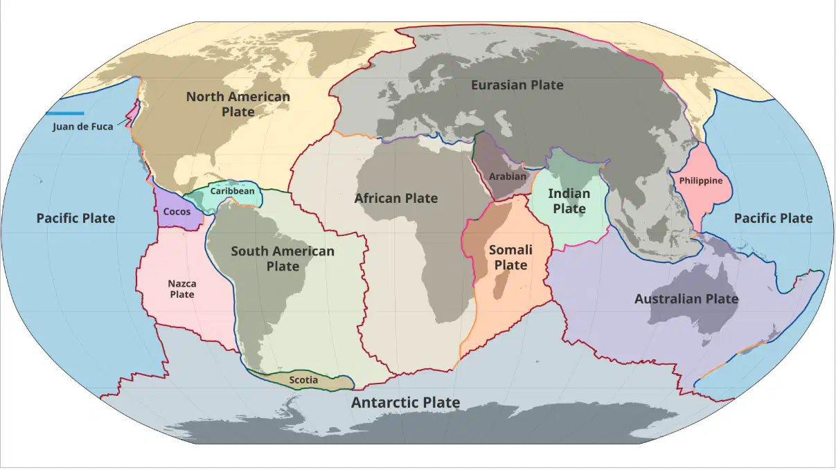
Which tectonic plate is located to the east of the South American Plate?
Nazca Plate
African Plate
Indian Plate
Australian Plate
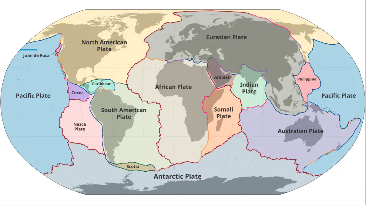
Which tectonic plate is directly north of the Indian Plate?
Arabian Plate
Eurasian Plate
African Plate
Philippine Plate
What is the "Ring of Fire" primarily known for?
A region known for its frequent earthquakes and volcanic activity
A famous tourist destination
A large desert area
A historical trade route
What is weathering?
The process of rocks being moved by water, wind, or ice
The wearing away of something by wind, rain, chemicals, and ice
A large mass of ice that moves slowly over time
The formation of mountains
What is erosion?
The process of rocks being worn away by chemicals
The movement of weathered bits of rock by water, wind, or ice
The slow movement of glaciers
The rapid formation of valleys
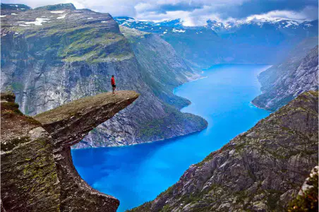
What is a glacier?
A large mass of ice that moves slowly over time
A type of rock formation
A process of chemical weathering
A rapid movement of water
What is a plateau?
A flat piece of land that rises above surrounding land
A low-lying area with water
A mountain range
A valley
Why is the temperature on a plateau usually cooler than in lower areas?
Because it is closer to the sun
Because it is higher in elevation
Because it is surrounded by water
Because it is covered in ice
What are plains typically used for?
Mining and drilling
Settling, growing crops, and building cities
Skiing and snowboarding
Fishing and boating
What is an isthmus?
A large body of water
A narrow strip of land connecting two larger land areas
A mountain range
A deep ocean trench
What is a continental shelf?
A mountain peak
A narrow strip of land
Plains under the ocean that border the continents
A deep ocean trench
What is a trench in geographical terms?
A wide river
A long, narrow, and steep cut in the ground or the ocean floor
A flat desert area
A high plateau
Where do we usually get our drinking water from?
Rivers, lakes, rain, glaciers
Oceans
Deserts
Mountains only
What is the process called that makes saltwater drinkable?
Filtration
Desalination
Evaporation
Condensation
What percentage of Kuwait’s water comes from desalination?
50%
70%
90%
100%

