
 Worksheets
Quarter 1 Test - Mapping and Plate Tectonics
Total questions: 22
Worksheet time: 11mins
Which lines run north and south along the earth’s surface?
latitude lines
longitude lines
equator
parallels
The starting line for measuring latitude is the
Prime Meridian
Arctic Circle
International Dateline
Equator
The highest number of degrees in latitude is
45
90
180
360
The line of longitude that measures 0 degrees is known as the
prime meridian
equator
international date line
north pole

The location of position C would best be described as
70W, 0
0, 70W
0N, 70W
10 S, 70 W

What is the latitude and longitude of point L?
5E, 30N
5W, 30S
5N 30E
5S 30W
On a topographic map, a stream flowing downhill is indicated when the V-shaped contour lines (the "vee") point:
Downstream (in the direction the water is flowing).
Upstream (opposite the direction the water is flowing).
Perpendicular to the direction of flow.
In the direction of true North.
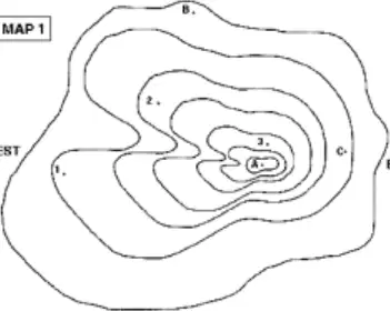
A student is examining a topographic map. Area 'B' shows contour lines widely spaced apart, while Area 'A' shows contour lines closely spaced together. Which statement correctly interprets the slope of these two areas?
Area A has a steeper slope than Area B.
Area B has a steeper slope than Area A.
Both areas have the same slope, but different elevations.
The slope in Area B is an example of an anticline.
A hiker measures a trail on a map to be 5 centimeters long. If the map's fractional scale is 1:24,000, how far did the hiker actually walk?
120,000 centimeters, or 1.2 kilometers
24,000 centimeters, or 0.24 kilometers
5 kilometers
12 meters
Which layer of the Earth is liquid and is responsible for generating the planet's magnetic field?
Crust
Mantle
Outer Core
Inner Core
The supercontinent that existed approximately 200 million years ago, according to the theory of Continental Drift, is known as:
Rodinia
Gondwanaland
Pangea
Laurasia
A plate boundary characterized by two plates sliding horizontally past each other is known as:
Divergent boundary
Transform boundary
Convergent boundary
Subduction zone
The process where new oceanic crust is formed at mid-ocean ridges and pushed away from the ridge is called:
Rifting
Seafloor spreading
Subduction
Plate consolidation
What specific geological feature is primarily formed when two continental plates collide?
Mid-ocean ridge
Deep-sea trench
Volcanic island arc
Large mountain range (e.g., the Himalayas)
Why do scientists use the ages of rocks found on the ocean floor to support the theory of seafloor spreading?
The oldest rocks are found furthest from the mid-ocean ridge.
The youngest rocks are found furthest from the mid-ocean ridge.
Rock age is randomly distributed across the ocean floor.
The rocks are all uniformly young, proving rapid formation.
Which of the following is the best description of the relationship between Earth's lithosphere and asthenosphere?
The liquid asthenosphere floats above the solid lithosphere.
The lithosphere is rigid and moves over the ductile, semi-fluid asthenosphere.
Both layers are entirely solid and move independently of one another.
The asthenosphere is the thinnest layer and provides all of Earth's heat.

If the diagram above shows two oceanic plates moving towards each other, resulting in one plate sinking beneath the other, the expected features would include a deep-sea trench and:
A large transform fault.
A continental rift valley.
A chain of volcanic island arcs.
A non-volcanic mountain range.
Why are earthquakes stronger and deeper at convergent boundaries compared to divergent boundaries?
Transform faults absorb most energy at divergent zones.
The cold, rigid subducting slab causes friction and stress deep in the mantle.
Magma release at divergent boundaries instantly relieves all pressure.
Convergent boundaries only occur where continental crust is thickest.
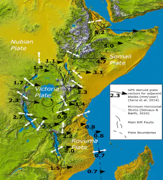
Based on the features shown on the map, the East African Rift Valley is an example of a continental divergent boundary. If this process continues for tens of millions of years, what is the most likely geological outcome?
The formation of a major subduction zone.
The creation of a new, narrow ocean basin.
The development of a passive continental margin.
A reversal of the magnetic polarity in the region.
Chambers are forming, and the lithosphere is thinning. This data strongly indicates the presence of a:
Transform boundary in a mature stage.
Convergent boundary involving subduction.
Divergent boundary in an initial rifting stage.
Passive continental margin.
A geologist measures the magnetic orientation of ancient rocks and finds a pattern of alternating "normal" and "reversed" magnetism perpendicular to a mid-ocean ridge. This pattern is best used to determine the rate of:
Sea level change.
Seafloor spreading.
Continental collision.
Mantle convection.
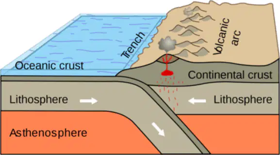
31. At an oceanic-continental plate boundary where the oceanic plate subducts beneath the continental plate, what is the expected distribution of earthquakes and volcanism?
Shallow and deep earthquakes with volcanism present
Only shallow earthquakes with no volcanism
Only deep earthquakes with no volcanism
No earthquakes and no volcanism

