
 Worksheets
Earth Science Chapter 2 Test
Total questions: 45
Worksheet time: 35mins
Eratosthenes, an ancient Greek scientist, is perhaps most famous for having calculated what to a high degree of accuracy?
the distance from the Earth to the Moon
the speed of light
the circumference of the Earth
the age of the universe
What is cartography?
the study of the Earth's surface, its atmosphere and its features
the study and practice of making maps
the average weather in a place over many years
the study of the human past
What geographic tool uses at least four satellites to provide locations on the Earth?
globe
map
satellite imagery
GPS
What geographic tool uses organizations and institutions to collect data about the Earth?
globe
satellite imagery
GPS
GIS
What do the initial GIS stand for?
Geological Information System
Geographical Information System
Graphing Information System
Geological Intelligence System
Which geographic tool is a space-based global navigation satellite system, shows your exact location on Earth and uses the letters GPS?
Geographical Positioning System
Geographical Political System
Global Positioning System
Global Political System
Early mapmakers tried to make their maps more accurate by using the--
rocks and trees
sun and stars
seasons
animal skins
How is a globe more accurate than a map?
a globe is a 3 dimensional model of the Earth, but a map is flat
a globe can show streets and roads, but a map cannot
a globe can show all of the continents at once, but a map cannot
a globe can be used to navigate from one town to another, but a map cannot
The elevation refers to the height of an area above sea level.
True
False
This shows how distances on a map compare to actual distances on land
compass rose
scale
key
title
Flat representation of the Earth's surface
map
globe
Type of map that shows borders that divide nations from one another as well as cities
political map
physical map
population map
transportation map.
What is the main purpose of map projections?
To create a three-dimensional representation of the Earth
To remove distortion in size and shape of land masses
To accurately depict the cardinal directions
To navigate marine travel
What is the disadvantage of the Mercator map projection?
Creates bias in perception of developed and less developed countries
Distorts the size of land masses near the poles
Difficult to interpret information
Interrupts the land masses
Which map features are used to find locations?
map legends
contour lines
latitude & longitude lines
map scales
Which mapping option shows differences in elevation of the land?
cylindrical
geologic
topographic
conical
All of the following are true about Global Positioning System (GPS) except.
Uses satellites that orbit around Earth.
A receiver uses at least 3 signals to calculate location.
Satellites send signals to receivers on Earth.
Uses compasses & telescopes to help hand draw maps.

Which TWO reference points are necessary to determine an exact location?
Select TWO answers.
Altitude
elevation
longitude
latitude
Which of the following indicates the elevation on a topographic map?
Contour Line
Contour Interval
Meridian
Scale
All world map projections create distorted images of the Earth to some degree. These distortions relate to size, shape, direction, and distance.
True
False

sextant
chronometer
octant
astrolabe
This was created my John Harrison to enable navigators to make accurate plots of their positions at sea for the first time.
compass
chronometer
astrolabe
octant

What is the approximate elevation at grid 7-I? (see figure 1)
140 ft
170 ft
200 ft
230 ft

Which of the following is the best estimate of the difference in elevation between Black Bear Camp and Eagle Peak? (see figure 2)
400 m
900 m
1200 m
1500 m

What is the elevation at point X? (see figure 3)
240 ft
250 ft
280 ft
300 ft
What is the contour interval?
The difference between the highest and lowest point of elevation
Connects points of equal elevation.
Is the shape and size of the land features on Earth's surface.
The difference in elevation between two contour lines
If the contour lines on a map are closer together the hill would have a
steep
gradual

What is the elevation of point B? (see figure 4)

What are the darker lines called?

What is the contour interval of this map? (see figure 5)

Equator
Prime Meridian
International Date Line
North Pole

Equator
Prime Meridian
International Date Line
North Pole
What are latitude and longitude lines, used to find an exact location of a place on Earth?
Imaginary lines that divide the earth
Visible lines that divide the earth
Long and short lines that divide the earth

Which letter is located at
(60°N, 60°E)? (see figure 6)
A
B
C
D

Which letter is located at
(0°, 150°W)? (see figure 6)
D
E
F
G

The red triangle seen on this map can be measured as _____° N (latitude) & _____° E (longitude).
80° N, 120° E
60° N, 120° E
30° N, 100° E
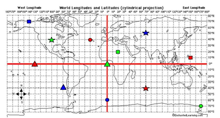
What are the coordinates for the RED Square?
40*S, 70*E
40*N, 30*W
0*, 130*W
10*N, 150*E

Which STATE is located at...
105°W, 47°N. (see figure 9)

What line of LONGITUDE is Point A located? (see figure 10)
Earth's true shape is a
Sphere
Square
Oblate Spheroid
A computer system to collect, display, and analyze data about Earth's surface
GPS
GIS
Remote Sensing
Which of the following is information that remote sensing can show?
color of the land
changes in earth's surface
location
Satellites are able to use sensors to detect infrared and visible radiation. What type of information collected from a satellite would be most beneficial to a meteorologist making a weather forecast in a given area?
Shape and height of clouds
Visualization of elevation changes
Type of vegetation present
Shape of the sea floor

