
 Worksheets
LO 4.2 Show Navigational Equipment
Total questions: 107
Worksheet time: 3hrs 41mins

Look at the image of the ship's bridge. Identify two pieces of navigational equipment visible in the image.
Radar and compass
Anchor and lifeboat
Engine room and galley
Cargo hold and crane
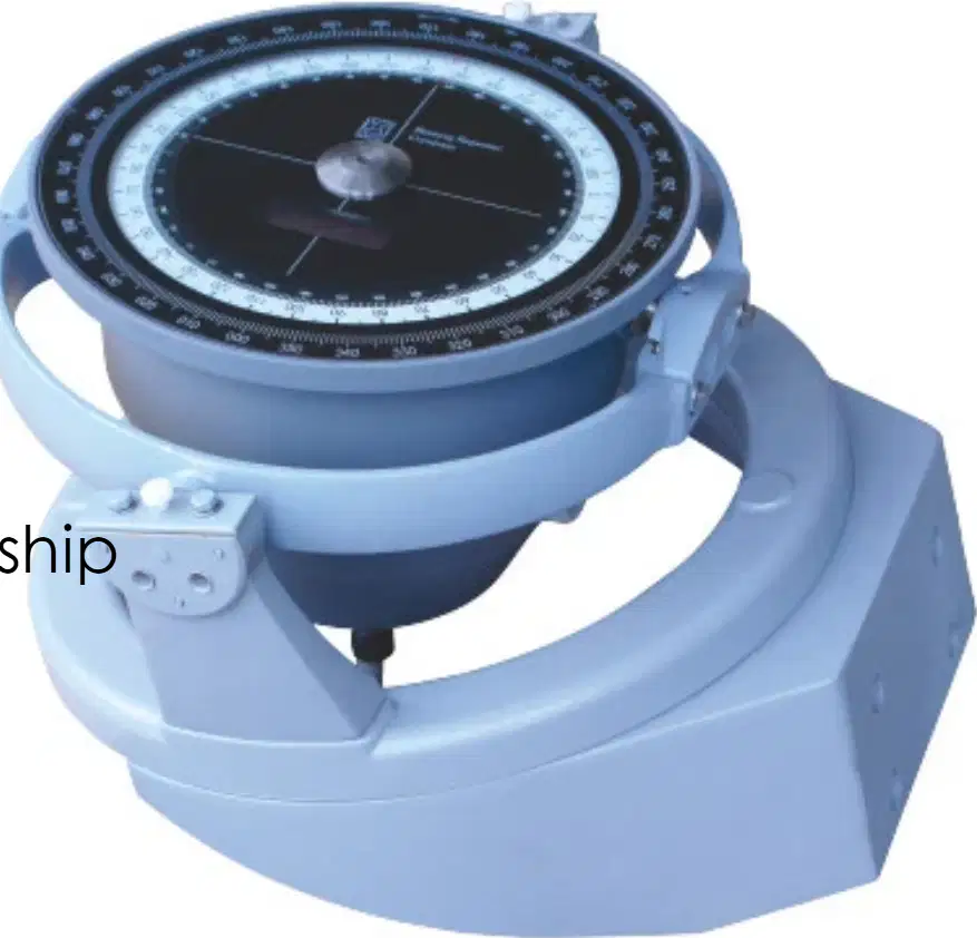
What is a gyro compass?
A navigational instrument that finds true north using the principles of a rapidly spinning gyroscope and the rotation of the Earth.
A device that measures temperature.
A tool used for drawing circles.
A magnetic compass used for navigation.
Fill in the blank: A gyro compass is not affected by the Earth's ________ field.
magnetic
gravitational
electric
thermal
Which of the following is a function of a gyro compass?
Indicates true north (not magnetic north)
Measures air pressure
Detects earthquakes
Measures humidity
A gyro compass is unaffected by magnetic disturbances such as metal structures or electronic equipment on a ship.
True
False
Which modern systems can a gyro compass integrate with?
Autopilot, radar, and ECDIS for heading input
Thermometer and barometer
GPS and altimeter
Speedometer and odometer
What does RADAR stand for?
Radio Detection and Ranging
Radio Direction and Response
Rapid Detection and Reporting
Remote Detection and Ranging
Fill in the blank: RADAR is a system that uses ______ waves to detect and locate objects such as ships, landmasses, and weather systems.
radio
sound
infrared
ultraviolet
Which of the following is NOT a function of the radar compass?
Navigation and collision avoidance
Cooking food
Weather monitoring
Surveillance and security
The radar compass helps in precise navigation in congested harbors and narrow waterways by providing detailed imagery of the surroundings.
True
False
Which system does the radar compass integrate with to automatically track targets and assess collision risks?
GPS
ARPA (Automatic Radar Plotting Aid)
AIS (Automatic Identification System)
SONAR
Name one condition where radar is especially useful for detecting other vessels and obstacles.
Poor visibility conditions (fog, night, storms)
Calm and clear weather
When the sun is shining brightly
During routine maintenance checks

What does the image on the right show?
A radar compass system displaying radar data.
A GPS navigation system showing a map.
A sonar display for underwater detection.
A weather monitoring station interface.
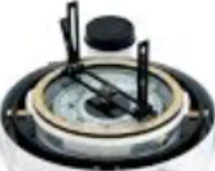
What is a magnetic compass?
A device that uses electricity to find direction
A simple instrument that uses a magnetized needle to align with the Earth's magnetic field, pointing to magnetic north
A tool for measuring temperature
A device for measuring speed
Fill in the blank: A magnetic compass is a _______ instrument that uses a magnetized needle to align with the Earth's magnetic field.
simple
complex
digital
optical
Which of the following is NOT a function of a magnetic compass?
Basic navigation tool
Points to magnetic north
Requires electrical power to operate
Subject to deviation from nearby metal objects
A magnetic compass is simple and requires no power, making it a vital backup in case of electronic failure.
True
False
Fill in the blank: The direction indicated by a magnetic compass can vary slightly from true north depending on location. This is called magnetic _______ or declination.
variation
inversion
reflection
rotation
What is an autopilot?
A manual steering device for ships
An electronic system that automatically controls the ship's steering to follow a set course without constant manual input from the helmsman
A type of navigation map
A fuel-saving device
Which function of autopilot helps officers to focus on monitoring the surroundings instead of manually steering?
Maintains a predefined course
Reduces crew workload
Improves fuel efficiency
Integrates with navigation systems
Fill in the blank: Autopilot helps keep the ship on a straight course, minimizing unnecessary rudder movements and saving _______.
fuel
time
water
space
Which navigation systems can autopilot integrate with?
GPS
Gyro compass
ECDIS
All of the above
An autopilot system requires constant manual input from the helmsman to control the ship's steering.
True
False
What does AIS stand for?
Automatic Identification System
Automated Information Service
Advanced Identification Signal
Automatic Information System
Which of the following is NOT a function of the Automatic Identification System (AIS)?
A) Collision avoidance
B) Traffic monitoring
C) Cooking food
D) Search and rescue
Fill in the blank: AIS helps ships detect and track nearby vessels, showing their course, speed, and ______ to avoid collisions.
identity
weather
cargo
destination
Which system assists vessel traffic services (VTS) on shore in managing and monitoring maritime traffic in busy areas like ports and straits?
GPS
AIS
RADAR
SONAR
In emergencies, how does AIS help rescue services?
AIS helps rescue services locate a vessel quickly by tracking its signal.
AIS provides weather updates to rescue services.
AIS automatically repairs damaged vessels during emergencies.
AIS sends distress signals directly to nearby aircraft.
What type of information can be displayed on an AIS device?
Information such as ship identity, position, speed, course, and other important data.
Only weather updates and sea temperature.
Details about marine wildlife in the area.
Information about upcoming port events and festivals.
What is a speed log (or ship log) used for on ships?
To measure the speed and distance traveled through water or over the ground
To measure the temperature of the water
To record the number of crew members
To monitor fuel consumption
A speed log provides real-time speed data to the bridge and navigation systems.
True
False
Fill in the blank: A speed log shows either speed through water (____) or speed over ground (____), depending on the type of log and integration with GPS.
STW, SOG
SOG, STW
RPM, SOG
STW, RPM
Which of the following is NOT a function of a speed log?
Measures ship's speed
Records distance traveled
Feeds other systems with speed data
Cooks food for the crew
The speed log records the total distance a ship has traveled during a voyage, which is important for navigation, fuel planning, and record-keeping.
True
False
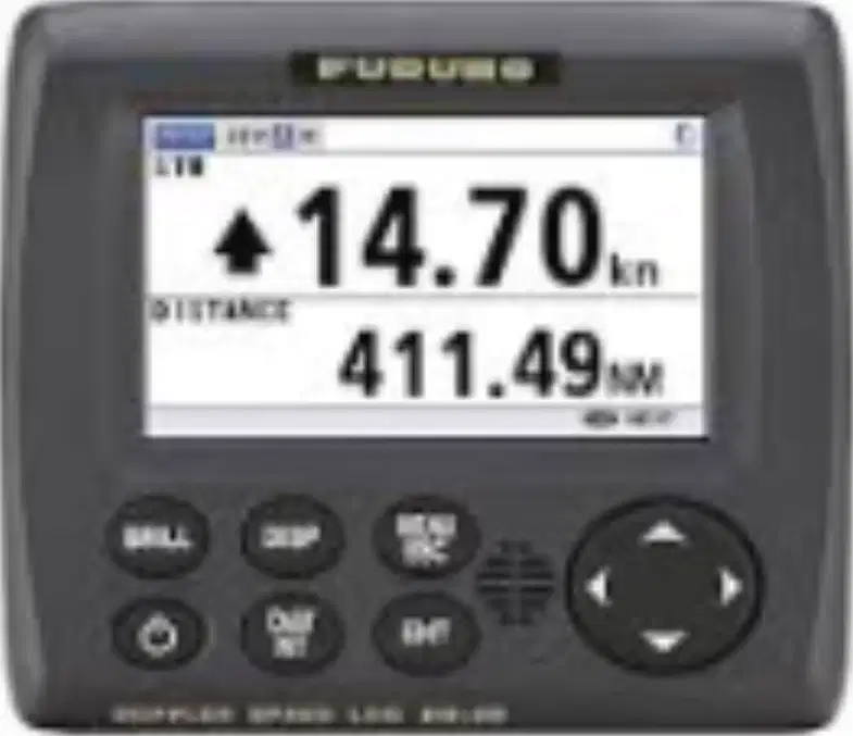
Refer to the image of the speed log device. What is the speed shown on the display?
14.70 kn
411.49 NM
20.00 kn
100.00 NM
What is the primary function of an echo sounder?
To measure air pressure
To measure the depth of water beneath a ship
To measure wind speed
To measure temperature
Fill in the blank: An echo sounder works on the principle of ______ by sending sound pulses from the ship's bottom to the seabed and measuring the time it takes for the echo to return.
sonar (Sound Navigation and Ranging)
refraction
magnetism
photosynthesis
Which of the following is NOT a function of an echo sounder?
Depth measurement
Safe navigation
Data logging
Weather forecasting
An echo sounder assists in safe navigation by:
measuring the depth of water beneath a vessel
detecting the presence of other ships nearby
providing weather forecasts for the route
indicating the direction of the wind
An echo sounder records depth data over time, which can be reviewed for navigation analysis or chart updating.
True
False
What does VHF stand for in the context of marine communication systems?
Very High Frequency
Variable High Frequency
Very Heavy Frequency
Variable Heavy Frequency
VHF radios are essential tools for communication between ships, and between ships and shore stations (like harbors or coast guards).
True
False
Fill in the blank: The marine band for VHF radio specifically operates between ____ to ____ MHz.
156 to 174 MHz
108 to 137 MHz
30 to 50 MHz
225 to 400 MHz
The primary function of Channel 16 on a VHF radio is:
To serve as the international distress, safety, and calling channel
To broadcast weather updates continuously
To provide private communication between ships
To play entertainment music for crew members
Which of the following is NOT a function of VHF radio?
Ship-to-ship and ship-to-shore communication
Emergency communication
Cooking food
Navigation safety
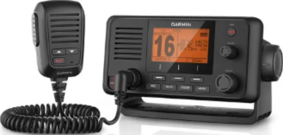
Refer to the image of the VHF radio device. What is the channel number displayed on the screen?
16
12
06
22
What does NAVTEX stand for?
Navigational Text
Navigational Telex
National Telex
Navigation Terminal
NAVTEX is used to broadcast which of the following information to ships?
Entertainment news
Maritime safety information, weather forecasts, navigational warnings, and urgent alerts
Sports updates
Financial news
Fill in the blank: Ships receive messages automatically and display or print them, ensuring crews are continuously updated with ________ information without manual intervention.
safety
weather
cargo
entertainment
Which function allows crews to filter messages by geographic area and message type to avoid overload and focus on relevant information?
Area selection
Message forwarding
Priority override
User tagging
NAVTEX receivers work 24/7, ensuring ships get timely updates even when no one is monitoring the system directly.
True
False
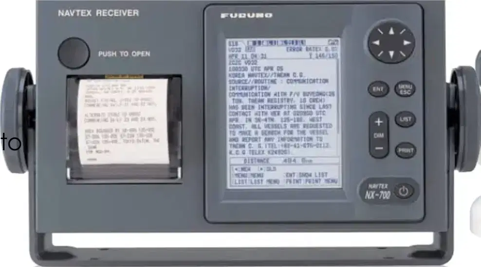
The primary purpose of the NAVTEX receiver on a ship is to:
Receive navigational and meteorological warnings and forecasts
Monitor engine performance
Track the ship's position using GPS
Control the ship's autopilot system
What does ECDIS stand for?
Electronic Chart Display and Information System
Electronic Communication Data Integration System
Enhanced Chart Data Information System
Electronic Control Display and Information System
Which of the following is NOT a function of the Electronic Chart Display and Information System (ECDIS)?
A) Navigation and route planning
B) Cooking food for the crew
C) Position tracking
D) Chart management
ECDIS uses data from which of the following sources?
GPS
Radar
AIS (Automatic Identification System)
Television
ECDIS provides automatic alerts for dangers such as shallow water, restricted zones, or proximity to land or other vessels.
True
False
What is the main purpose of chart management in ECDIS?
To update electronic charts automatically to ensure the most current data is available.
To display weather forecasts on the navigation screen.
To control the speed of the vessel automatically.
To monitor engine performance in real time.
What information is typically displayed on the ECDIS screen?
The ECDIS screen typically displays electronic charts, the ship's real-time position, and navigation routes.
The ECDIS screen typically displays weather forecasts and crew schedules only.
The ECDIS screen typically displays engine performance data and fuel consumption rates.
The ECDIS screen typically displays entertainment options and meal menus.
What does GPS stand for?
Global Positioning System
General Positioning Service
Global Placement System
Geographic Positioning Satellite
GPS provides accurate location, speed, and time information anywhere on Earth, in any weather, at any time.
True
False
Which function of GPS provides real-time location data for precise navigation and tracking?
Navigation
Positioning
Speed and Course Monitoring
Timing and Synchronization
Which function of GPS guides the ship along pre-planned routes and helps in route correction?
Navigation
Positioning
Speed and Course Monitoring
Integration with Other Systems
Which function of GPS displays the ship's speed over ground and its exact course, aiding in safe and efficient travel?
Timing and Synchronization
Integration with Other Systems
Speed and Course Monitoring
Positioning
GPS works with systems like ECDIS, AIS, radar, and autopilot to enhance situational awareness and automated control.
True
False
Which function of GPS offers accurate time signals, which are essential for communication and data logging systems on board?
Navigation
Timing and Synchronization
Positioning
Speed and Course Monitoring
What is the main purpose of wind indicators in navigational equipment?
To measure temperature
To provide real-time wind speed and direction data
To track fuel consumption
To monitor engine performance
Wind indicators help navigators with course adjustment to avoid hazards like ________ and optimize a vessel's speed and sail trim.
storms
reefs
currents
fog
Which of the following is NOT a function of wind indicators?
Planning more efficient routes
Contributing to fuel savings
Cooking food on board
Helping with course adjustments
Wind indicators provide accurate wind speed and direction during emergencies, allowing the crew to take proactive safety measures.
True
False
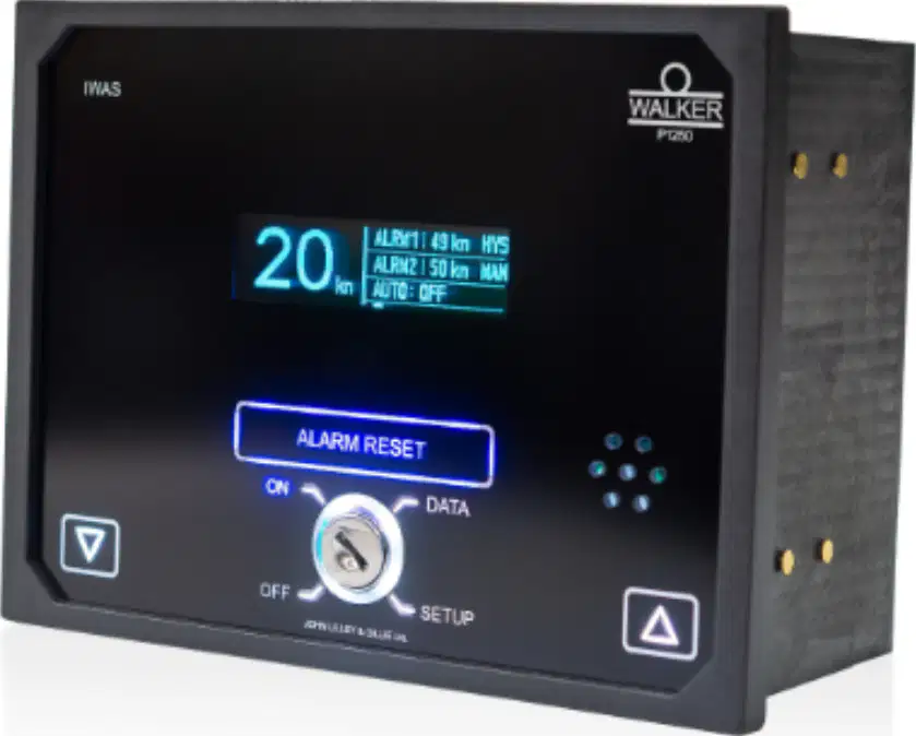
Refer to the image of the wind indicator device shown. What information does this device provide to navigators?
Wind speed and direction
Water temperature
Fuel level
Engine status
According to the passage, what is the main purpose of navigational lights in maritime navigation?
Decoration
Collision avoidance and position indication
Communication with land
Fishing
Navigational lights are legally required and work by using specific colors, arcs of visibility, and placement to provide vital visual information.
True
False
Fill in the blank: Navigational lights help mariners identify other vessels’ _______, direction, and movement to prevent collisions.
position
speed
size
color
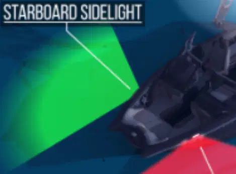
Which light is shown at the front right (starboard) side of the vessel in the diagram?
Port sidelight
All-round light
Starboard sidelight
Stern light
What does ARPA stand for in navigational equipment?
Automatic Radar Plotting Aid
Automated Route Planning Application
Advanced Radar Positioning Algorithm
Automatic Radio Positioning Aid
Which of the following is NOT a main function of ARPA?
A) Automatic target acquisition and tracking
B) Plotting the course and speed of targets
C) Cooking food automatically
D) Providing collision alarms
Fill in the blank: ARPA calculates the Closest Point of Approach (____) and Time to Closest Point of Approach (____) to evaluate collision risk.
CPA, TCPA
CPA, ETA
RPA, TCPA
CPA, TCA
Which function of ARPA predicts each target’s future course and speed, shown as a vector line on the display?
Collision alerts
Vector prediction
Collision risk assessment
Automatic target acquisition
What does ARPA issue when collision risks are detected based on set CPA and TCPA limits?
Weather reports
Collision alerts
Navigation charts
Speed warnings
The primary use of this equipment in navigation is:
Determining direction
Measuring temperature
Calculating speed
Recording sound
What is the primary purpose of a Voyage Data Recorder (VDR)?
To navigate the ship
To aid in accident investigations by providing a comprehensive record of the ship's voyage
To communicate with other ships
To control the ship's engine
Fill in the blank: A Voyage Data Recorder (VDR) functions as a ship's ________, continuously recording data from navigational equipment, communications, and vessel status.
black box
engine room
radar system
lifeboat
Which of the following types of data does the VDR collect?
GPS position
Bridge audio
Engine orders
Food inventory
The data stored by the VDR is kept in a protected capsule that can survive extreme conditions.
True
False
Three types of information recorded by the VDR as mentioned in the passage are:
Audio recordings, ship's position, and radar data
Weather forecasts, crew salaries, and engine color
Passenger lists, food menus, and entertainment schedules
Cargo weight, ship's flag, and paint type

Refer to the image of the device labeled 'Voyage Data Recorder.' What instruction is written on the device regarding its handling?
DO NOT OPEN -- REPORT TO AUTHORITIES
OPEN FOR MAINTENANCE ONLY
HANDLE WITH CARE -- FRAGILE
FOR CREW USE ONLY
Which of the following is a primary purpose of a GPS system on a ship?
To provide entertainment
To navigate and determine position
To cook food
To monitor fuel levels
Fill in the blank: The _______ is a device that measures the depth of water beneath a ship.
speed log
radar
sonar
compass
What is the main function of a ship's VHF radio?
To communicate with other vessels and shore stations
To measure the ship's speed
To provide weather updates
To track cargo
Fill in the blank: The _______ system is used for automatic tracking of vessels and collision avoidance.
Global Positioning
Sonar
Automatic Identification
Radar
What is the primary purpose of an Automatic Identification System (AIS)?
To control ship engines remotely
To communicate with satellites
To track and identify vessels automatically
To provide weather forecasts
Which instrument is used to measure the angle of a ship's heel?
Clinometer
Gyrocompass
Echo sounder
Speed log
Fill in the blank: The ______ is a device that helps determine a ship's position using celestial bodies.
GPS
sextant
compass
radar
True or False: A ship's chart is only used for navigation and has no other purposes.
False
True
What is the primary purpose of an echo sounder in navigation?
To detect other vessels
To determine water depth
To measure the speed of the vessel
To provide weather updates
Which of the following is a limitation of a magnetic compass?
It cannot be used at night
It requires electrical power
It is affected by nearby magnetic fields
It can only be used in open waters
What does ECDIS stand for in maritime navigation?
Emergency Communication and Data Integration System
Electronic Compass and Directional Indicator System
Electronic Chart Display and Information System
Electronic Control and Display Interface System
Which type of navigation system uses satellites to determine position?
Inertial navigation system
Global Positioning System (GPS)
Celestial navigation
Dead reckoning
What is the primary purpose of a ship's echo sounder?
To measure the ship's speed
To communicate with shore stations
To determine water depth
To track other vessels
Which of the following is a key advantage of using AIS over traditional radar?
It identifies vessels by name and other details
It has a longer range than radar
It provides real-time weather updates
It requires less power to operate
What does the term 'dead reckoning' refer to in navigation?
Tracking the ship's course using GPS
Using celestial navigation techniques
Calculating current position based on previous known positions
Determining the ship's speed through water
Which device is used to measure the angle of heel of a ship?
Magnetometer
Speed log
Inclinometer
Gyrocompass
What is the primary purpose of a radar system in maritime navigation?
To provide entertainment on board
To detect underwater currents
To track the position of other vessels and obstacles
To measure the temperature of the sea
Fill in the blank: The term 'AIS' stands for Automatic Identification ______.
System
Signal
Service
Source
Which of the following is a key advantage of using GPS for navigation?
It requires no power source
It provides real-time positioning information
It is the only navigation method available
It is unaffected by weather conditions
What does the term 'dead reckoning' refer to in navigation?
Relying solely on visual landmarks
Following a predetermined course without adjustments
Using celestial bodies for navigation
Calculating one's current position based on a previously determined position
Fill in the blank: The primary function of a VHF radio is to facilitate ______ communication.
satellite
long-range
emergency
local

