
 Worksheets
Final exam questions: lithosphere, atmosphere
Total questions: 63
Worksheet time: 50mins
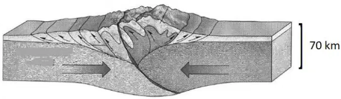
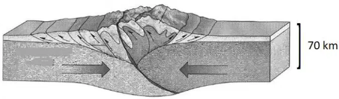
The figure shows two thick continental crust blocks colliding and crumpling into high mountains; a scale bar at 70 km is shown. Based on the figure, which types of tectonic plates are colliding?
Two continental plates
Two oceanic plates
An oceanic plate and a continental plate
A continental plate and a microplate at a transform boundary
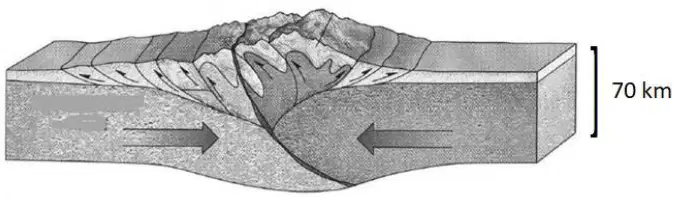
According to the same figure of colliding thick crustal blocks, what primarily drives the movement of the tectonic plates?
Heat-driven convection in Earth’s interior
Prevailing surface winds
Ocean tides
Solar heating of continents
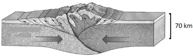
During mountain building produced by this type of continent–continent plate collision, which rock types predominantly build the mountains?
Sedimentary rocks such as limestone and sandstone
Basaltic pillow lavas
Ultramafic rocks from the mantle
Glacial till and loess
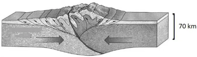
Which structural movement is most closely associated with the mountain building in a continent–continent collision like the figure?
Folding of rock layers
Normal faulting that forms rift valleys
Strike‑slip motion along transform faults
Seafloor spreading at a mid‑ocean ridge
Name the mountain system whose formation began in the Mesozoic as a result of continent–continent collisions of this type. Which pair of plates played a role?
Eurasian mountain system; Eurasian and African plates
Circum‑Pacific mountain system; Pacific and Nazca plates
East African Rift system; Nubian and Somali plates
Himalayan system; Pacific and Philippine plates

Which phenomenon can accompany mountain building in large plate collisions? Choose one example.
Earthquakes
Quiet, stable crust
Auroras
Permanent daylight
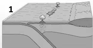
Figure 1 shows two plates converging; a subducting slab dips beneath the other plate and a curved chain of volcanic islands rises above the subduction zone. What collision of plate types does Figure 1 represent?
Oceanic–oceanic plate collision
Continental–continental plate collision
Oceanic–continental plate collision
Divergent plate boundary
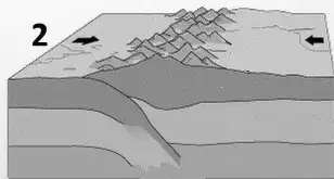
Figure 2 shows two plates converging and producing a high, wide fold‑and‑thrust mountain belt. What collision of plate types does Figure 2 represent?
Continental–continental plate collision
Oceanic–oceanic plate collision
Oceanic–continental plate collision
Transform boundary between two continents
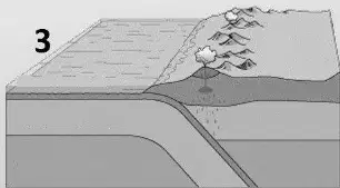
Figure 3 shows plate boundary with a trench offshore and a volcanic mountain chain inland. What collision of plate types does Figure 3 represent?
Continental–continental plate collision
Oceanic–continental plate collision
Oceanic–oceanic plate collision
Divergent boundary within a continent
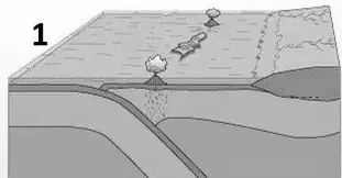
In Figure 1, what is the name of the structural feature that forms at the surface?
Island arc
Rift valley
Transform fault zone
Mid‑ocean ridge
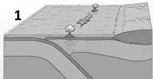
Which rock type commonly builds the surface features produced in Figure 1 ?
Andesite
Granulite
Basaltic komatiite
Evaporite
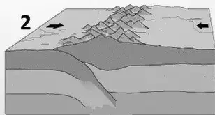
In Figure 2, what structural element develops as the plates converge?
Mid‑ocean ridge
Oceanic trench
Shield volcano
Fold mountain belt
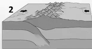
Which rock type is characteristic of the mountains formed in Figure 2 ?
Basaltic glass
Peridotite
Limestone
Chert from hydrothermal vents
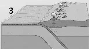
The volcano associated with the process in Figure 3 belongs to which type?
Fissure volcano forming plateaus
Shield volcano
Stratovolcano (composite)
Caldera‑only system with no cone
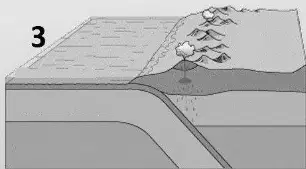
Which rock type is commonly associated with the volcanoes formed in Figure 3 (oceanic–continental subduction)?
Andesite
Peridotite
Basalt of mid‑ocean ridges
Evaporitic gypsum
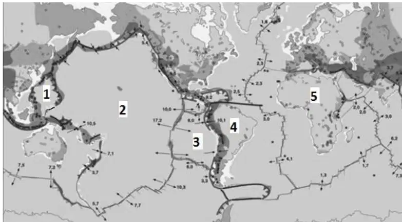
Study the map sketch showing tectonic plate movements and match each numbered plate on the map to its name.
1
Philippine Plate (Philippine Sea Plate)
2
Pacific Plate
3
Nazca Plate
4
South American Plate
5
African Plate
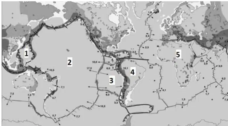
On this same map, what mountain range formed along the boundary between the plates labeled 3 and 4?
Himalayas
Rocky Mountains
Alps
Andes
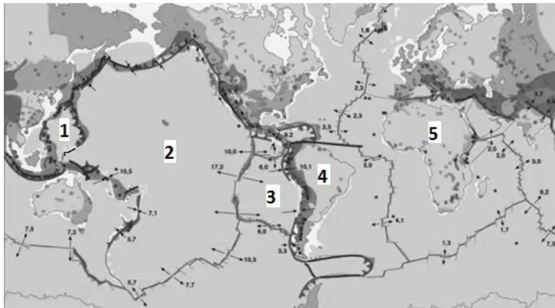
According to the same map, which pair of numbered plates collided to form the Mariana Trench?
1 and 2
2 and 3
3 and 4
4 and 5
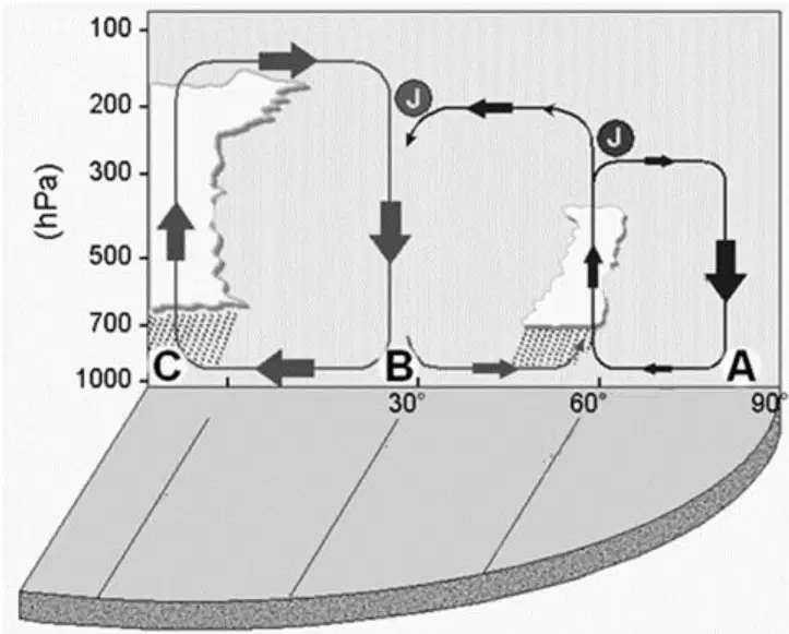
The figure shows the Northern Hemisphere’s pressure belts with surface labels at specific latitudes: A at about 90° N (pole), B at about 30° N (subtropics), and C at 0° (Equator). For location A, identify the type of surface pressure and the main cause.
High pressure caused by cold, dense air near the pole
Low pressure caused by strong surface heating at high latitudes
Low pressure created by rising warm, moist air
High pressure formed by intense convergence and uplift at the surface
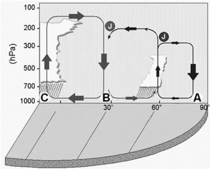
The same figure shows location B at about 30° N. Identify the type of surface pressure and the main cause there.
Low pressure produced by equatorial‑type surface heating at 30° N
High pressure produced by descending air from the Hadley cell
Low pressure caused by frequent polar‑air outbreaks
High pressure produced mainly by very cold surface air pooling
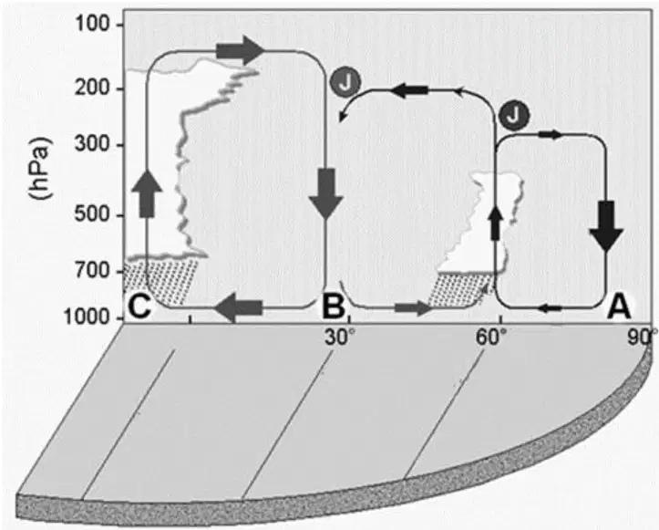
At location C on the Equator (0°) in the same figure, identify the type of surface pressure and the main cause.
High pressure due to cold, dense air
Low pressure produced by intense heating and rising air
High pressure from widespread descending air at the horse latitudes
Low pressure from strong radiative cooling of the surface
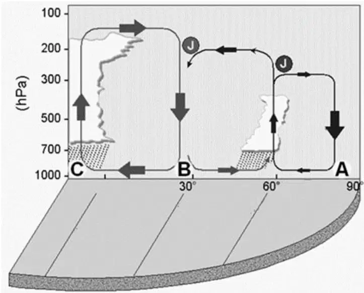
Using the same figure, determine the following about winds and the trade‑wind belt in the depicted hemisphere.
Letters that bound the trade‑wind system in the diagram
C–B
Direction of the trade wind in the depicted hemisphere
Northeasterly
Direction of the winds between 30∘ and 60∘ latitude
Westerly (southwesterly)
Where is the upper boundary of the troposphere higher—over the Equator or over the poles—and why?
Over the Equator, because gravity is slightly weaker and vigorous convection raises the tropopause
Over the poles, because cold dense air expands the troposphere upward
Over the poles, because Earth’s rotation compresses the equatorial atmosphere
It is about the same everywhere because the atmosphere has uniform thickness
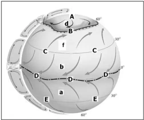
Study the globe diagram of global atmospheric circulation with belts labeled A, B, C, D, E and wind arrows labeled a, b, d, f at latitudes near 0°, 30°, and 60°. Match each labeled belt to the type of air pressure that predominates there. Keep the alphabetical order.
A
High pressure belt
B
Low pressure belt
C
High pressure belt
D
Low pressure belt
E
High pressure belt
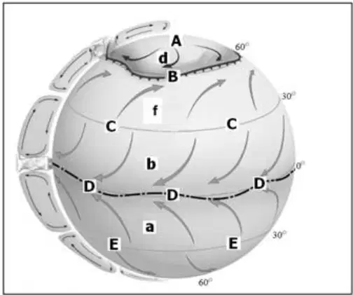
According to the same globe diagram, what is the primary cause of the pressure conditions in belt A?
Cold, dense air accumulates and sinks near the pole
Strong surface heating causes air to rise
Sea–land contrast produces a seasonal monsoon
Mountain barriers force subsidence
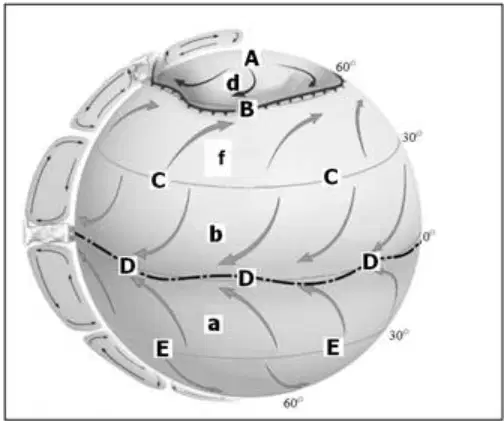
On the globe diagram, what mainly causes the pressure conditions in belt D at the equator?
Warm, rising air of the intertropical convergence zone
Cold, sinking air of the polar dome
Persistent anticyclones accumulating over oceans
Downslope winds from subtropical highs

On the globe diagram, which process best explains the pressure conditions in belt B around 60° latitude?
Year‑round strong insolation creates persistent thermal lows
Cyclones forming along the polar front create a belt of low pressure
Subtropical anticyclones intensify and spread poleward
Topography blocks westerlies and causes stagnation highs
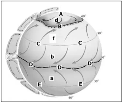
On the globe diagram, which process best explains the pressure conditions in belt C around 30° latitude?
Rising air and convergence along the equator
Sinking air and accumulation of anticyclones produce subtropical highs
Cold-air pooling beneath a polar dome
Low pressure systems caused by heated continents
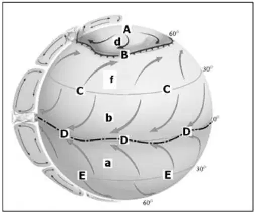
Based on the globe diagram, why does air move from belt C toward belt D?
Ocean currents drag the air from belt D toward belt C
Coriolis force pushes air from the equator to the subtropics
Friction reverses the pressure difference near the surface
Air flows from higher pressure toward lower pressure due to pressure difference
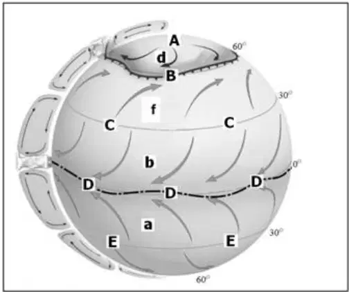
Using the same globe, match each small-lettered airflow to its wind system.
a
Trade-wind system
b
Trade-wind system
f
Westerlies wind system
d
Polar wind system
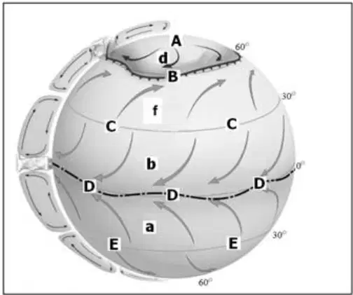
Which labeled airflow on the globe carried Christopher Columbus westward across the Atlantic to America?
a
b
d
f
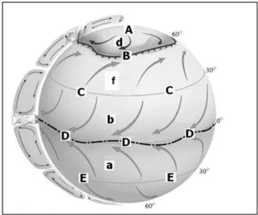
Which labeled airflow on the globe, when seasonally modified, develops into the wind responsible for India’s summer rainfall?
a
b
d
f
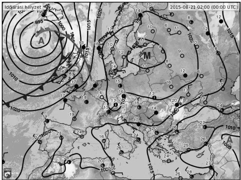
Study the synoptic weather map of Europe showing closed curved lines with numbers (isobars) and frontal symbols. What large-scale atmospheric formation is located near the British Isles?
A tropical cyclone making landfall
A blocking anticyclone (high‑pressure area)
A mid‑latitude cyclone (low‑pressure area)
A thermal low caused by surface heating
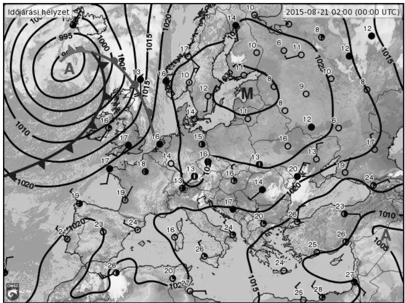
On the same weather map, what is the fundamental cause of the formation near the British Isles?
Surface heating over land causing a sea breeze circulation
Rising air and cyclogenesis along the polar front due to strong temperature contrast
Cold, sinking air building a subtropical high pressure system
Topographic blocking by the Alps creating a stationary high pressure system
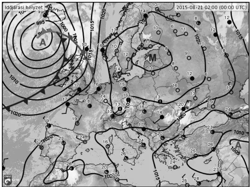
In the formation near the British Isles on the map, in which direction does Earth’s rotation deflect moving air?
To the right of its path in the Northern Hemisphere
To the left of its path in the Northern Hemisphere
Toward the equator regardless of hemisphere
Toward the poles regardless of hemisphere
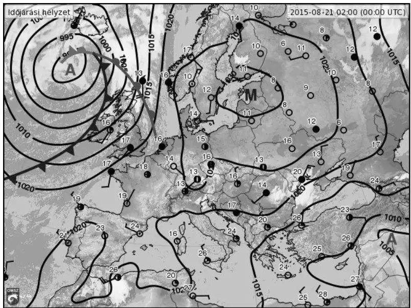
On the synoptic map, the numbers written on the dark, closed curved lines represent which quantity and in what units?
Air pressure in hectopascals (hPa)
Temperature in degrees Celsius (°C)
Wind speed in knots
Relative humidity in percent (%)
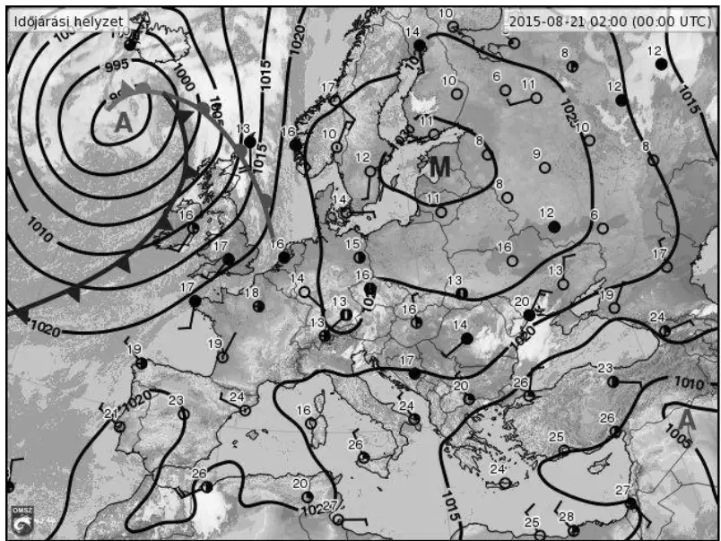
What do we call the closed curved lines with the numbers on the synoptic map?
Contour lines
Isotherms
Isobars
Streamlines
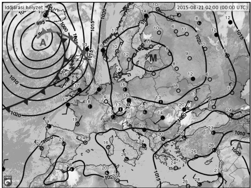
Why did cloud form within the atmospheric system shown on the map? Choose the sequence that correctly links motion, temperature change, relative humidity, and phase change.
Air rises → adiabatic cooling → relative humidity increases to saturation → condensation forms cloud
Air sinks → adiabatic warming → relative humidity decreases → evaporation creates cloud
Air flows horizontally → no temperature change → relative humidity stays constant → deposition produces cloud
Air rises → adiabatic warming → relative humidity decreases → sublimation forms cloud
Decide whether the statement is true or false: Inside a cyclone, the air flows downward.
True
False
Decide whether the statement is true or false: In the northern temperate zone, a warm front always develops after a cold front.
True
False
Decide whether the statement is true or false: Anticyclones cause clear weather.
True
False
Decide whether the statement is true or false: A tornado is a typical tropical cyclone.
True
False
Decide whether the statement is true or false: The arrival of a cyclone’s warm front is indicated by cumulus cloud formation.
True
False
Decide whether the statement is true or false: An occluded front forms when the cold front and the warm front merge.
True
False
Decide whether the statement is true or false: Jet streams are the fastest airflows in a cyclone.
True
False
Decide whether the statement is true or false: Air pressure at the center of an anticyclone is higher than its surroundings.
True
False
Select the wind system that matches the statement: The Indian subcontinent is under the dominance of this wind system.
westerlies
trade winds
tropical monsoon
temperate monsoon
Select all wind systems that match the statement: The thermal equator plays a role in its operation. Options: westerlies; trade winds; tropical monsoon; temperate monsoon.
westerlies
trade winds
tropical monsoon
temperate monsoon
Select all wind systems that match the statement: Seasonal reversal of direction is characteristic. Options: westerlies; trade winds; tropical monsoon; temperate monsoon.
westerlies
trade winds
tropical monsoon
temperate monsoon
Select the wind system that matches the statement: Jet streams play a role in its formation.
westerlies
trade winds
tropical monsoon
temperate monsoon
Select the wind system that matches the statement: Arises primarily from the interaction of large land and water surfaces.
westerlies
trade winds
tropical monsoon
temperate monsoon
Select the wind system that matches the statement: Typically found on the eastern sides of continents.
westerlies
trade winds
tropical monsoon
temperate monsoon
Select the wind system that matches the statement: Transports expansive cyclones and anticyclones.
westerlies
trade winds
tropical monsoon
temperate monsoon
Select the wind system that matches the statement: In the Northern Hemisphere summer it reaches land as a southwesterly wind.
westerlies
trade winds
tropical monsoon
temperate monsoon
Select the wind system that matches the statement: Alternation of ascending and descending branches shapes the climate of the transitional zone.
westerlies
trade winds
tropical monsoon
temperate monsoon
Select the wind system that matches the statement: The defining wind of the Korean Peninsula.
westerlies
trade winds
tropical monsoon
temperate monsoon
Select the wind system that matches the statement: Due to it, the North Atlantic Current’s positive temperature anomaly can extend to the area of Hungary.
westerlies
trade winds
tropical monsoon
temperate monsoon
Select the wind system that matches the statement: Characteristic between 30∘ and 60∘ latitude in both hemispheres.
westerlies
trade winds
tropical monsoon
temperate monsoon
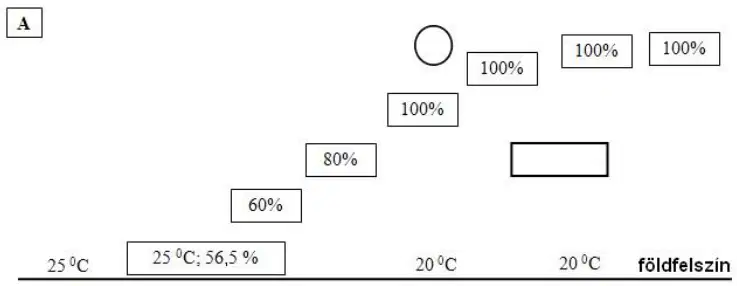
Study the two cross‑sections labeled A and B that show atmospheric conditions along weather fronts, then answer: What type of front is shown in diagram A?
Warm front
Cold front
Stationary front
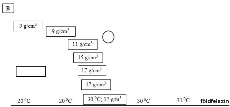
Study the two cross‑sections labeled A and B that show atmospheric conditions along weather fronts, then answer: What type of front is shown in diagram B?
Warm front
Cold front
Occluded front
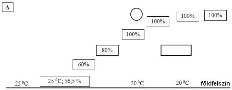
In diagram A, which air mass is advancing along the front?
Warm air advances, sliding up over retreating cold air
Cold air undercuts warm air and advances
Neither air mass advances; the front is stationary
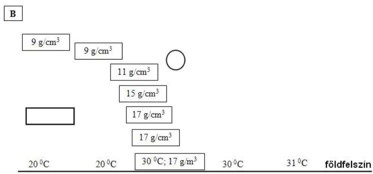
In diagram B, which air mass is advancing along the front?
Warm air advances over cold air
Cold air advances, undercutting warm air
Neither air mass advances; the front is stationary
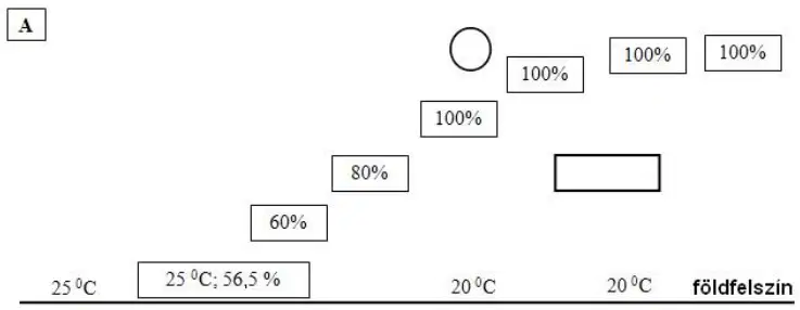
On diagram A, where should the horizontal line be drawn to mark the dew point level?
At the first level where relative humidity reaches 100%
At the level labeled 60%
At the surface temperature label near 25 ∘C
Only at the very topmost 100% box

