
Human Geography: Introduction to Maps
Presentation
•
Social Studies
•
7th Grade
•
Medium
Brandon Harrison
Used 13+ times
FREE Resource
35 Slides • 36 Questions
1
2
3
4
5
Open Ended
INTERPRET
this map as time passes...
(what's going on exaclty?)
IDENTIFY
historical events/people that could possibly be connected to the events of this map.
6
7
8
9
10
11
12
13
14
15
16
17
18
Multiple Choice
What does a Political Map show you?
Elevation
States and Countries
Temperature
Roadways
19
Multiple Choice
What type of map is this?
Physical map
Thematic map
Political map
Choropleth
20
Multiple Choice
What type of map is this?
Thematic map
Locator map
Physical map
Road map
21
Multiple Choice
What type of map is this?
Dot distribution
Physical map
Political map
Road map
22
Multiple Choice
What type of map shows you elevation?
Topographic map
Political map
Thematic map
Locator map
23
24
25
26
Multiple Choice
What is a compass rose?
half of a circle that helps people find angles
a drawing showing different directions on a map
a device with a magnet that always points North
a pretty flower on a map that is red
27
Multiple Choice
What is this?
A compass
Symbol for large city
Compass Rose
Part of a puzzle
28
Multiple Choice
What purpose does a Compass Rose serve on a map?
Looks pretty and smells good.
Shows where a major city is located.
Tells you which way to hold the map.
Shows the Cardinal Directions.
29
30
Multiple Choice
What is the Absolute Location of Denver?
west of St. Louis
105 degrees W by 39 degrees N
Southeast of Seattle
39 degrees W by 105 degrees N
31
32
Multiple Choice
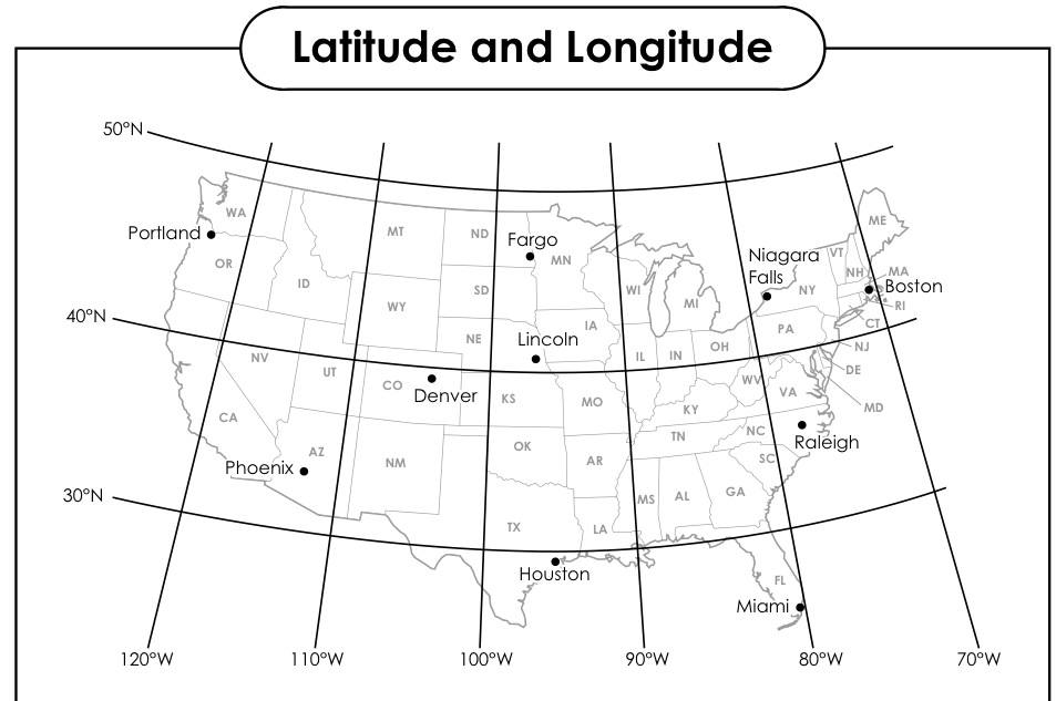
What is the Absolute Location of Miami?
26°S, 90°W
26°N, 88°W
26°N, 80°W
26°N, 80°S
33
Multiple Choice
Which of these BEST describes the (Relative) location of South Carolina?
Middle West United States
Northwestern United States
Southwestern United States
Southeastern United States
34
Multiple Choice
The specific location on the Earth is an example of what type of location?
Relative
Cardinal
Absolute
35
Multiple Choice
Antarctica is located south of the Equator is an example of what type of location?
Absolute
Relative
36
Multiple Choice
The Equator divides our Earth into what two hemispheres?
Eastern & Western Hemispheres
Southern & Eastern Hemispheres
Northern & Southern Hemispheres
37
Multiple Choice
Direction & distance from one location to another is an example of what type of location?
Absolute
Relative
38
39
Multiple Choice
What map feature tells you what the map symbols mean?
Legend
Title
Compass
Scale
40
Multiple Choice
Explains the symbols on a map.
Title
Label
Legend
Compass Rose
41
Multiple Choice
Another word for Legend is...
Story
Key
Title
Label
42
Multiple Choice
What is a scale on a map?
a tool that allows you to measure your body weight
a way to balance the weights of the land and oceans
a ratio of the distance on the map to the actual distance
a piece of skin found on reptiles like snakes
43
Multiple Choice
What map feature tells you the ratio between size in real life and size in the map?
Scale
Title
Legend
Compass
44
Multiple Choice
Which one of these options describes someone who makes maps?
Cartographer
Writer
Artist
Historian
45
46
47
48
49
50
See Video on Map Distortions attached in todays Google Classroom assignment folder...
51
Open Ended
Now that you have watched the video...
Describe in detail why are all world maps wrong!
52
53
54
55
56
57
58
59
Multiple Choice
A formal culture region differs from other regions in that it
is one that people believe exists
has a selected feature or internal uniformity
does not contain gradations such as core, domain, and sphere
applies only to linguistic and religion regions
60
Multiple Choice
Every map projection has some degree of distortion because
a curved surface cannot be represented on a flat surface without distortion
parallels and meridians never cross at right angles on a globe
the grid system is two-dimensional, while the real world is three-dimensional
latitude lines are shorter than meridian lines
61
Multiple Choice
Which of the following statements about the Robinson projection is correct?
It is more useful for long-distance navigation than the Mercator projection.
It is better for making topographical maps than the Mercator projection.
It is more accurate than the Mercator projection in showing the sizes of countries in higher latitudes.
It is more useful for showing the distribution of human populations than the Mercator projection.
It is better for estimating territorial waters in lower latitudes than the Mercator projection.
62
Multiple Choice
Which of the following is a characteristic of the Mercator projection?
The size and shape of countries in the higher latitudes are greatly exaggerated.
The size of all countries is accurate, but the shape is distorted.
Countries near the Equator appear 50 percent larger than countries in the middle latitudes.
The projection is designed to maintain undistorted outlines of landmasses.
Distances on the Mercator projection are real and accurate
63
Multiple Choice
How many hemispheres does planet Earth have?
one
two
three
four
64
Multiple Choice
Which of the following map projections severely distorts the size of Greenland?
Mercator
Robinson
Winkel Tripel
Peters Projection Map
65
Multiple Choice
Which of the following is the most accurate model of the Earth?
printed map
planar projection
globe
Mercator Projection
66
Multiple Choice
What is relative location?
describes an exact position on the Earth's surface
expresses where a location is in relations to another location
explains how and why people and things move
none of the above
67
Multiple Choice
Which of the following is an example of absolute location?
Bancroft Street
45 degrees North, 110 degrees West
The University of Toledo is west of SFS
McDonalds
68
Multiple Choice
People, ideas, goods, etc that are transported from one location to another describe the theme of _____.
Place
Region
Interaction
Movement
69
Fill in the Blank
Type answer...
70
Multiple Choice
71
Fill in the Blank
Type answer...
Show answer
Auto Play
Slide 1 / 71
SLIDE
Similar Resources on Wayground
65 questions
LESSON 3: BOOLEAN EXPRESSIONS & SELECTION STATEMENTS
Presentation
•
7th Grade
67 questions
Unit 5 Antebellum Era Quizizz Lesson 3
Presentation
•
8th Grade
61 questions
Unit 8b Cortes & the Aztecs
Presentation
•
7th Grade
68 questions
Europe's Environmental Issues
Presentation
•
6th Grade
63 questions
SPEED and VELOCITY
Presentation
•
7th Grade
65 questions
The Republic Weakens & Republic to Empire
Presentation
•
6th - 8th Grade
65 questions
Ecosystems Guided Lesson
Presentation
•
6th - 8th Grade
64 questions
Ocean Currents, Air Currents and Weather
Presentation
•
6th - 8th Grade
Popular Resources on Wayground
10 questions
5.P.1.3 Distance/Time Graphs
Quiz
•
5th Grade
10 questions
Fire Drill
Quiz
•
2nd - 5th Grade
20 questions
Equivalent Fractions
Quiz
•
3rd Grade
22 questions
School Wide Vocab Group 1 Master
Quiz
•
6th - 8th Grade
20 questions
Main Idea and Details
Quiz
•
5th Grade
20 questions
Context Clues
Quiz
•
6th Grade
20 questions
Inferences
Quiz
•
4th Grade
12 questions
What makes Nebraska's government unique?
Quiz
•
4th - 5th Grade
Discover more resources for Social Studies
7 questions
India Independence - SS7H3a
Presentation
•
7th Grade
15 questions
CCR Review-2.0
Quiz
•
6th - 8th Grade
14 questions
Cotton, Cattle and Railroads
Quiz
•
7th Grade
10 questions
Economic Effects of CCR Lesson
Presentation
•
6th - 8th Grade
20 questions
Capitalism vs. Government Control Quiz
Quiz
•
7th Grade
30 questions
Age of Oil FAC Quiz
Quiz
•
7th Grade
24 questions
Unit 7: SS7H3 Test Review
Quiz
•
7th Grade
23 questions
India's Independence Movement
Quiz
•
7th Grade