Explore Wayground's comprehensive collection of free human population geography worksheets and printables that help students analyze demographic patterns, population density, and migration trends through engaging practice problems with included answer keys.
Human population worksheets available through Wayground (formerly Quizizz) provide comprehensive resources for exploring demographic patterns, population distribution, and the complex factors that influence human settlement across the globe. These expertly crafted materials strengthen critical analytical skills by engaging students in examining population density maps, interpreting demographic data, and understanding concepts such as birth and death rates, migration patterns, and urbanization trends. The worksheet collections include detailed answer keys that support independent learning and teacher assessment, while the free printable formats ensure accessibility for diverse classroom environments. Practice problems range from calculating population growth rates to analyzing the relationship between geographic features and settlement patterns, helping students develop quantitative reasoning skills alongside their geographic knowledge.
Wayground's extensive collection draws from millions of teacher-created resources specifically designed to support human population geography instruction across various educational contexts. The platform's robust search and filtering capabilities allow educators to quickly locate materials aligned with curriculum standards, whether focusing on global population trends, regional demographic studies, or local community analysis. Teachers benefit from flexible customization tools that enable differentiation for diverse learners, with resources available in both printable PDF formats for traditional classroom use and digital formats for interactive learning experiences. These features streamline lesson planning while providing targeted materials for remediation and enrichment activities, ensuring that educators can effectively address the complex concepts of human geography through systematic skill practice and comprehensive assessment opportunities.
FAQs
How do I teach human population geography to middle and high school students?
Start by grounding students in core demographic vocabulary: birth rate, death rate, natural increase, and population density. From there, use population density maps and demographic transition model diagrams to help students visualize how and why populations grow or decline in specific regions. Connecting data to real-world examples, such as comparing urbanization trends in Sub-Saharan Africa versus Western Europe, builds both geographic reasoning and analytical thinking.
What exercises help students practice analyzing population data?
Effective practice includes calculating natural increase rates from birth and death rate data, interpreting population pyramids to infer a country's age structure and development stage, and analyzing choropleth maps showing population density. Tasks that ask students to explain the relationship between geographic features, like rivers or arable land, and settlement patterns push beyond recall into applied reasoning. Mixing quantitative calculations with written analysis ensures students develop both numerical and interpretive skills.
What common mistakes do students make when studying human population concepts?
One of the most frequent errors is confusing population density with total population size, leading students to assume the most populous countries are also the most densely settled. Students also struggle to distinguish between immigration and emigration when interpreting net migration data, and often conflate high birth rates with high population growth without accounting for corresponding death rates. Addressing these misconceptions explicitly, with data-driven examples, significantly improves accuracy on assessments.
How can I use human population worksheets to support different skill levels in my classroom?
Human population worksheets can be scaffolded by adjusting the complexity of the data students are asked to interpret, from single-variable population bar graphs for developing learners to multi-factor demographic analyses for advanced students. On Wayground, teachers can apply individual accommodations such as read aloud support for students who need audio assistance, reduced answer choices to lower cognitive load, and extended time settings configurable per student. These accommodations are reusable across sessions, so differentiation does not require rebuilding setups for every lesson.
How do I use Wayground's human population worksheets in my classroom?
Wayground's human population worksheets are available as printable PDFs for traditional classroom use and in digital formats for technology-integrated environments, accommodating a range of teaching setups and student preferences. Teachers can also host worksheets directly as a quiz on Wayground, enabling real-time student responses and built-in assessment. Each worksheet includes a complete answer key, which supports both independent student review and efficient teacher grading.
How do I teach the demographic transition model effectively?
Present the demographic transition model as a framework for understanding how birth rates and death rates shift as societies industrialize and develop economically. Have students place real countries into the four stages using current demographic data, then ask them to justify their classifications in writing. This approach prevents rote memorization and builds the analytical reasoning needed to apply the model to unfamiliar regions on assessments.
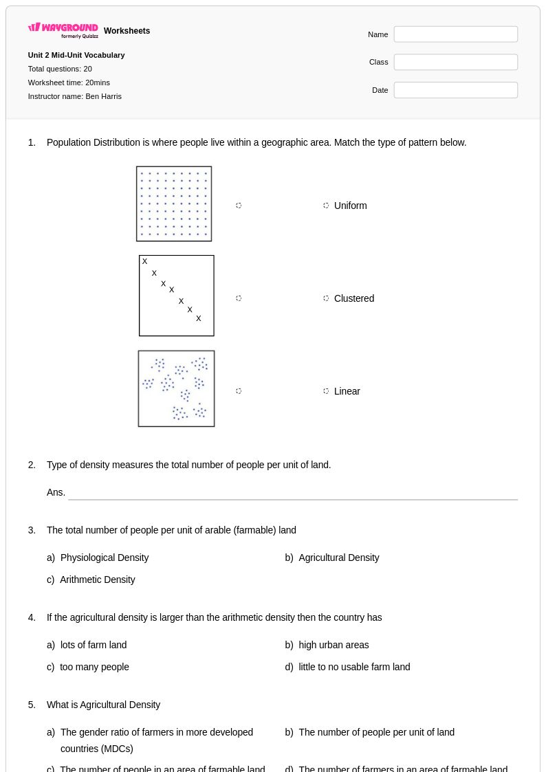
What is the relationship between geographic features and population distribution that students need to understand?
Students need to recognize that human populations cluster in areas with favorable physical geography, including flat, fertile land near freshwater sources, moderate climates, and coastal access for trade. Conversely, harsh environments such as deserts, dense rainforests, and high mountain ranges tend to support very low population densities. Understanding these patterns allows students to interpret population density maps critically rather than simply reading them as isolated data displays.