
 Worksheets
Plate Tectonics and Topo Maps
Total questions: 100
Worksheet time: 1hrs 28mins
Name
Class
Date
1.
The Great Rift Valley in Africa and the Mid-Ocean Ridge were all created by this boundary
a)
Divergent
b)
Convergent
c)
Reform
d)
Transform
2.
Which type of plate boundary would cause mountains to form?
a)
Transform
b)
Convergent
c)
Divergent
d)
Reform
3.
What are the two types of crust
a)
continental and oceanic
b)
ocean and upper
c)
lower and upper
d)
pizza and subway
4.
Earthquakes and volcanoes are most likely found in which locations?
a)
At plate boundaries
b)
in oceans
c)
in the middle of continents
d)
in the middle of plates
5.
The Himalayas in Asia are an example of what type of plate boundary?
a)
divergent
b)
continent-to-continent convergent
c)
ocean-to-continent convergent
d)
transform
6.
When one plate sides under neath another, it _________ and the magma _________.
a)
hardens, sinks
b)
melts, sinks
c)
hardens, rises
d)
melts, rises
7.

What is this image...
a)
Revolving boundary
b)
San Andreas (Transform)
c)
Convergent
8.
Two tectonic plates collide at a _______ plate boundary.
a)
convergent
b)
divergent
c)
transform
9.
Which of the following is NOT a tectonic boundary?
a)
Convergent
b)
Divergent
c)
Sedergent
d)
Transform
10.
The area where two tectonic plates meet.
a)
mantle
b)
focus
c)
plate boundary
d)
convection
11.
A mid-ocean ridge occurs at a ________ plate boundary.
a)
transform
b)
convergent
c)
divergent
12.

What is the name of the plate boundary that slides past each other?
a)
Divergent
b)
Convergent
c)
Transform
d)
Mr. C the Slide Man
13.

Which of these events can ONLY happen on a DIVERGENT BOUNDARY?
a)
Rift Valley
b)
Mountain
c)
A peninsula
d)
An Insanely complex, long answer that you will click out of instinct.
14.
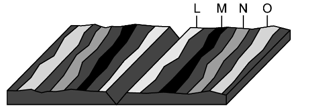
Where would the oldest rock be found?
a)
L
b)
M
c)
N
d)
O
15.
Which of the following is NOT evidence to support the theory of plate tectonics?
a)
Fossils
b)
Mountains
c)
Glaciers
d)
Sand Erosion
16.

What type of event will occur at this boundary?
a)
Earthquake
b)
Volcano Eruption
c)
Tornado
d)
Mountain Building
17.
A divergent boundary occurs when plates ....
a)
Pull apart
b)
Come together
c)
Slide past each other
d)
subducting
18.
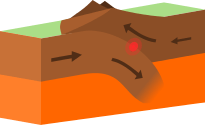
What type of plate boundary is this?
a)
Plate
b)
Divergent
c)
Convergent
d)
Transform
19.
What type of event will occur at this boundary?
a)
Earthquake
b)
Volcano Eruption
c)
Tornado
d)
Mountain Building
20.
Islands can from from magma which is pushed up at a __________ plate boundary
a)
Divergent
b)
Convergent
c)
Transform
21.
Mountains are created when....
a)
Two continental plates collide
b)
Two oceanic plates pull apart
c)
An Oceanic plate subducts under a Continental Plate
d)
Two continental plates pull apart
22.
How is it possible for new crust to be formed without increasing the surface area of the Earth?
a)
Crust is destroyed at the same time it is created
b)
New crust is underwater where it sinks
c)
New crust breaks more easily than old crust
23.

Many scientists think hot plastic-like rock in the mantle is forced upward toward the surface, cools, and sinks. This process is called a(n) _________.
a)
earthquake
b)
convergent boundary
c)
volcano
d)
convection current
24.

The _________ is the thinnest layer of Earth.
a)
outer core
b)
inner core
c)
mantle
d)
crust
25.

_______ are formed when two continental plates collide.
a)
Mountain ranges
b)
Transform faults
c)
Rift valleys
d)
Volcanoes
26.

The theory of continental drift was first proposed by __________.
a)
Thomas Edison
b)
Alfred Wegener
c)
Benjamin Franklin
d)
Harry Hess
27.

The theory of seafloor spreading was first proposed by __________.
a)
Thomas Edison
b)
Harry Hess
c)
Benjamin Franklin
d)
Alfred Wegener
28.

Which of the following was NOT a reason that many scientists refused to listen to Wegener’s ideas?
a)
he didn’t have evidence to back his ideas
b)
they were just plain mean
c)
most geologists at the time thought it was impossible for continents to move
d)
he was a meteorologist
29.

Which layer of Earth is made up partly of crust and partly of mantle material?
a)
lithosphere
b)
mantle
c)
asthenosphere
d)
crust
30.

The layer of caramel-like consistency that flows and moves the plates of the Earth is called the ________.
a)
mantle
b)
lithosphere
c)
crust
d)
asthenosphere
31.

The _______ is the thickest layer of the Earth at 1800 miles thick. This layer contains most of the mass of the Earth.
a)
crust
b)
mantle
c)
outer core
d)
inner core
32.

Plates move apart at _________ boundaries.
a)
volcanic
b)
divergent
c)
convergent
d)
transform
33.

_________ currents carry heat from the hot inner core to the cooler outer mantle and back again.
a)
River
b)
Radiation
c)
Convection
d)
Conduction
34.

Which type of plate boundary occurs at B?
a)
convergent
b)
divergent
c)
transform
d)
country
35.

The feature labeled C represents some of the deepest spots on the ocean floor. These areas are called ___.
a)
mid-ocean ridge
b)
trenches
c)
deep-sea vent
d)
abyssal plain
36.

The feature labeled D is part of the continuous underwater mountain range that circles Earth. It is called ___.
a)
mid-ocean ridge
b)
trenches
c)
deep-sea vent
d)
abyssal plain
37.

Which type of plate boundary is shown at A?
a)
transform boundary
b)
convergent boundary
c)
divergent boundary
d)
fractured boundary
38.

According to the table, very minor earthquakes happen
a)
1 per year
b)
18 per year
c)
6,200 per year
d)
thousands per day
39.
Where does a dense tectonic plate push under a less dense plate?
a)
subduction zone
b)
hot spot
c)
plate boundary
d)
fault
40.
This is the place where two tectonic plates meet.
a)
Hot spot
b)
subduction
c)
plate boundary
d)
fault
41.
An area of volcanic activity that is not near a plate boundary
a)
Hot spot
b)
subduction
c)
plate boundary
d)
fault
42.
The geological feature formed from an earthquake
a)
Hot spot
b)
subduction
c)
plate boundary
d)
fault
43.
What does the theory of plate tectonics predict about the location of earthquakes and volcanoes?
a)
They are evenly distributed across Earth’s surface.
b)
They occur mostly on the ocean floor.
c)
They occur mostly on the continents.
d)
They occur mostly at plate boundaries.
44.
Earth’s plates are moved by convection currents in the
a)
upper mantle
b)
crust
c)
lithosphere
d)
core
45.
Earth's plates are pieces of the
a)
asthenosphere
b)
mantle
c)
lithosphere
d)
core
46.
Earth’s tectonic plates sit atop and slide along with of these layers?
a)
lithosphere
b)
asthenosphere
c)
core
d)
crust
47.
Where are nonvolcanic mountain chains most likely to form?
a)
at a boundary between two colliding continental plates.
b)
at a boundary where one oceanic plate slides under another oceanic plate
c)
at a boundary where an oceanic plate slides under a continental plate
d)
in the middle of a continental plate
48.
Where do mid-ocean ridges form?
a)
where two continental plates collide
b)
where one oceanic plate slides under another oceanic plate
c)
where a continental plate slides under an oceanic plate
d)
where two oceanic plates move apart
49.
A hot spot can produce
a)
a mid-ocean ridge
b)
a chain of islands
c)
a rift valley
d)
a tectonic plate
50.
What happens when two oceanic plates collide?
a)
One plate pushes up the other forming mountains.
b)
They form a rift valley.
c)
They combine to form one plate.
d)
One plate slides under another.
51.
Which features of the ocean floor result from interactions of Earth's plates?
a)
trenches and seamounts
b)
canyons and seamounts
c)
rift valleys and canyons
d)
rift valleys and trenches
52.

The event that occurred along line XY was
a)
erosion
b)
faulting
c)
sedimentary deposition
d)
a volcanic eruption
53.
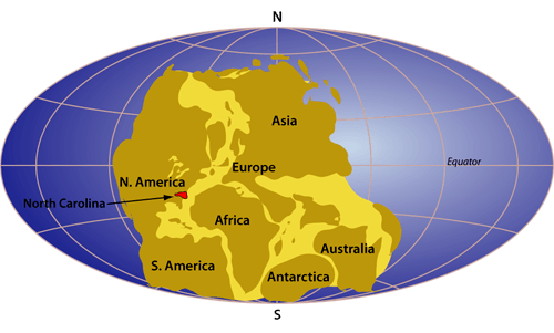
What is this a picture of?
a)
plate tectonics
b)
continental drift
c)
pangea
d)
glacier scaring
54.
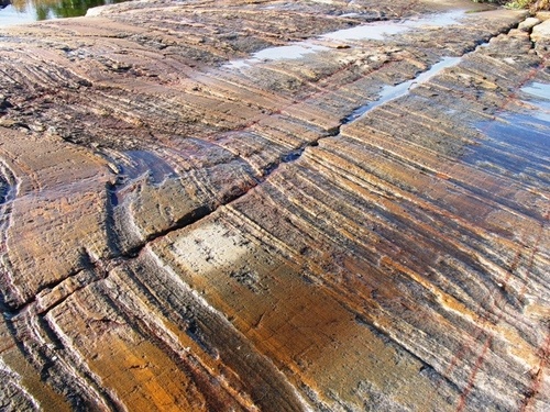
This is a picture of glacier scars found in Africa. What are these evidence for?
a)
Africa has always been near the equator
b)
Africa was once in an area of the Earth that had a very cold climate
c)
The continents have not moved
d)
sea floor spreading
55.
What does the theory of continental drift state?
a)
The continents were once joined in a super-continent and have moved over time
b)
Continents are stationary and do not move
c)
The Earth is broken into lithospheric plates that move due to convection currents
d)
none of the above
56.
What does the theory of continental drift state?
a)
The continents were once joined in a super-continent and have moved over time
b)
Continents are stationary and do not move
c)
The Earth is broken into lithospheric plates that move due to convection currents
d)
none of the above
57.
What evidence did Wegener use in his theory?
a)
Continents and fossils fitting together/matching-up like puzzle pieces
b)
glacier scars and evidence from temperature
c)
mountain ranges and coal deposits line up across continents
d)
all of the above
58.
What specific technology did Wegener use in his study?
a)
GPS
b)
Sonar
c)
Radar
d)
Maps
59.
What two specific continents fit together most noticeably?
a)
Africa and North America
b)
South America and Europe
c)
South America and Africa
d)
Antartica and Africa
60.
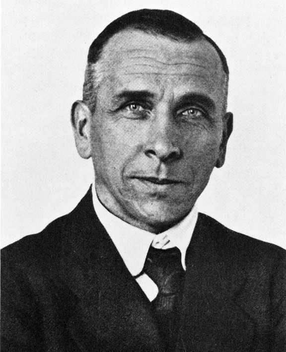
Who is the person credited with developing the theory of continental drift?
a)
Harry Hess
b)
Galileo
c)
Alfred Wegener
d)
Newton
61.
Why did no one believe Wegener's thoery?
a)
He could not explain HOW the continents moved
b)
He didn't have evidence
c)
His data was wrong
d)
He didn't use the right technology to gather data
62.

What is the elevation of point B?
a)
800 ft
b)
850 ft
c)
900 ft
d)
1000 ft
63.

In which direction is Mill River flowing?
a)
Southeast
b)
Southwest
c)
Northeast
d)
Northwest
64.

What is the elevation of Y?
a)
Between 120-140 meters
b)
Between 100-120 meters
c)
Between 140-160 meters
d)
Between 80-100 meters
65.

The distance from D to E is...
a)
A little over 2 km
b)
A little over 3 km
c)
A little over 4 km
d)
A little over 5 km
66.

If we were in a plane, Path B --> C is about the same distance as path E --> N. But, which path is the easier walk?
a)
B --> C is the easier walk
b)
E --> N is the easier walk
c)
B --> C and E --> N are the same walking distance
67.

What feature is formed at B?
a)
river
b)
rift valley
c)
sink hole
d)
mountain
68.

What feature is at the arrow?
a)
volcano
b)
mountain
c)
cliff
d)
river
69.

Determine the contour interval:
a)
5 m
b)
10 m
c)
15 m
d)
20 m
70.

How many mountain tops does this map have?
a)
one
b)
two
c)
three
d)
four
71.

What is the difference in elevation between Point X and Point Y?
a)
120 m
b)
240 m
c)
360 m
d)
340 m
72.

Provided is a topographic map of a hill with contour lines drawn showing elevation in meters.
The steepest slope on this hill can be found on the side that is facing which direction?
The steepest slope on this hill can be found on the side that is facing which direction?
a)
Southwest
b)
Northeast
c)
Northwest
d)
Southeast
73.

Match 1
a)
A
b)
B
c)
C
d)
D
74.

Match 3
a)
A
b)
B
c)
C
d)
D
75.

Which direction is the river flowing?
a)
north
b)
south
c)
east
d)
west
76.

Determine the contour interval:
a)
5 m
b)
10 m
c)
15 m
d)
20 m
77.

Determine the contour interval:
a)
5 m
b)
10 m
c)
15 m
d)
20 m
78.

What does this image represent?
a)
mountain
b)
depression or sinkhole
c)
beaches
d)
cave
79.

What is this symbol?
a)
mountain
b)
depression or sinkhole
c)
cave
d)
railroad central
81.

Determine the contour interval
a)
10 m
b)
20 m
c)
50 m
d)
100 m
81.
Determine the contour interval
a)
10 m
b)
20 m
c)
50 m
d)
100 m
82.

What is the map symbol (darker lines)?
a)
roads
b)
index contour
c)
contour interval
d)
waves
83.

Find the contour interval:
a)
5 ft
b)
10 ft
c)
20 ft
d)
25 ft
84.

Find the contour interval:
a)
10 ft
b)
20 ft
c)
25 ft
d)
100 ft
85.

What could be the lowest elevation in the depression?
a)
50 feet
b)
41 feet
c)
60 feet
d)
51 feet
86.
Find the contour interval:
a)
5 ft
b)
10 ft
c)
20 ft
d)
25 ft
87.

Find the contour interval:
a)
20 ft
b)
30 ft
c)
40 ft
d)
50 ft
88.
A topographic map should always have
a)
a elevation key to tell you what the highest and lowest points on the map are
b)
a legend to tell you what the contour interval is
c)
a compass rose to tell you which direction on the map is north
d)
a reference point to show you the best route to the highest point on the map
89.
Contour lines do not ever cross
a)
true
b)
false
90.
The elevation of the top of a mountain or hill is Question*
a)
the same as the circle around the top of the hill or mountain
b)
the circle contour plus the contour interval of the map.
c)
the same as the last index contour line
d)
more that the circular contour but less that the circular contour plus the contour interval
91.
Connect points of equal elevation, and are drawn at specific intervals
a)
index contours
b)
reference contours
c)
topographic contours
d)
contour lines
92.
The way that you know that an area is very steep on a map.
a)
the contour lines are very close together
b)
the contour lines are spaced far apart
c)
the contour lines run north to south
d)
the contour lines run south to north
93.
Circles on a map indicate
a)
a depression like a volcano crater
b)
the top of a hill or mountain
c)
a circular scenic trail
d)
a lake or pond
94.
A river or stream flow direction is indicated by
a)
the direction a "V" contour line on a map is pointing
b)
the opposite direction "V" contour lines on a map are pointing
c)
right angles to the direction "V" contour lines on a map are pointing
d)
in the direction of the ocean on every map
95.

A mountaineer is planning an expedition. He wants to follow the easiest possible path, which means he needs to find the most gentle slope up the mountain. Which route should the mountaineer choose?
a)
Route A
b)
Route B
c)
Route C
d)
Route D
96.

Based on the map below, which location has a greater elevation, A or B?
a)
Location A is higher.
b)
Location B is higher.
c)
Locations A and B are at the same elevation.
d)
It is impossible to determine which location is higher.
97.
The shape of the land is shown by connecting points of the same elevation to form a ____________.
a)
relief line
b)
slope
c)
valley
d)
contour line
98.
The bold lines that appear on the map every 5th contour line with the exact elevation written on it is the ______________________
a)
Index Contour line
b)
Contour interval
c)
Relief
d)
Slope
99.
The difference in elevation between two contour line is known as
a)
Gradual
b)
Steep
c)
Contour interval
d)
Index contour
100.

What is the change in elevation from point X to the top of the hill in the topographic map shown?
a)
303 m
b)
203 m
c)
250 m
d)
253 m
100 %

