

wayground logo

Free Printable Worksheets

Font size

S
M
L
XL
Worksheets

APHG Unit 1 Review

Total questions: 59

Worksheet time: 27mins

Name
Class
Date
1.
The location of a place using the latitude-longitude grid is called: 
a)
A.  referenced location 
b)
A.  central location
c)
A.  relative location
d)
A.  absolute location 
2.
The location of a place in relationship to other places or features around it is called: 
a)
absolute location
b)
relative location
c)
site
d)
situation
3.
Scale is…                                     
a)
the system used by geographers to transfer locations  from a globe to a map
b)
the extent of spread of a phenomenon over a given area
c)
 the difference in elevation between two points in an area
d)
 the relationship between the length of an object on a map and that feature on the landscape
4.
The process of the spread of an idea and/or dissemination of an innovation from its source area to other cultures, is the process of cultural: 
a)
diffusion
b)
simultaion
c)
adaptation
d)
movement
5.
The physical qualities of the original location for a city is referred to as the
a)
site
b)
situation
c)
relative location
d)
absolute location
6.
The visible imprint put on the environment by people is called?
a)
Cultural Landscape
b)
Place
c)
Location
d)
Human Environment Interaction
7.
What is it called when you take a 3D image and put it onto a 2D surface?
a)
Cartogram
b)
Projection
c)
Globe
d)
Instagram
8.
Billy thinks that in the south, everyone eats grits, eats fried chicken and watches football.  He would be creating what type of region of the south with these ideas?
a)
Formal
b)
Functional
c)
Perceptual
d)
Uniform
9.
Measuring the distance people are willing to travel to shop at a store would be creating what type of region for that store?
a)
Formal
b)
Perceptual
c)
Functional
d)
Uniform
10.
Geographers group like things together into regions in order to make them easier to study.  What type of region would a corn field be?
a)
Perceptual
b)
Formal
c)
Functional
d)
Vernacular
11.
The spread of ideas, inventions, or patterns of behavior is called ____.
a)
acculturation
b)
innovation
c)
cultural hearth
d)
diffusion
12.
Places that share similar characteristics are called 
a)
human systems
b)
environments
c)
regions
d)
physical systems
13.
Which of the following shows places on the Earth's surface the most accurately?
a)
thematic maps
b)
globes
c)
general-purpose maps
d)
physical maps
14.
Imaginary North-South line that passes through Greenwich, England, and has a value of 0 degrees
a)
latitude
b)
longitude
c)
relief
d)
scale
15.
What are lines on a globe drawn in an east-west direction and measured in degrees?
a)
longitude
b)
latitude
c)
grid
d)
equator
16.
Environment influences, but does not strictly determine, how a culture interacts with the environment.
a)
Environmental Determinism
b)
Environmental Possibilism
c)
Cultural Determinism
d)
Cultural Environmentalism
17.
The physical environment causes social and cultural development.
a)
Cultural Environmentalism
b)
Environmental Possibilism
c)
Environmental Determinism
d)
Cultural Possibilism
18.
Culture is spread by...
a)
Movement of people
b)
TV and Internet
c)
War and conquest
d)
All are correct
19.
This image demonstrates
a)
Regions
b)
Stimulus Diffusion
c)
Globalization
d)
None of the above
20.
What is a Region
a)
Tells us ways in which the places in an area are alike
b)
Tells us what makes an area special and what makes it different from every other area
c)
Tells us where people and places are
d)
None of the Above
21.
The idea that one's environment is responsible for who people are and how they live
a)
Positivism
b)
'Merica
c)
Possibilism
d)
Environmental Determinism
22.
The map projection with the greatest amount of distortion, although visually appealing because of its nice, straight lines, is called _____.
a)
Mercator
b)
Gall-Peters
c)
Azimuthal
d)
Homolosine
23.
The concept of distance decay is best described in which scenario?
a)
When fewer people read the Review Journal newspaper the farther you are away from Las Vegas.
b)
People throughout a region generally speaking German.
c)
When many people move to another area using an ocean vessel.
d)
The diffusion of a disease along a highway corridor.
24.
A two-dimensional representation of the earth
a)
Map
b)
Globe
c)
Projection
25.
The relationship between any phenomenon and the earth as a whole.  Looking at the impact something has locally, regionally, globally, etc....
a)
Space
b)
Diffusion
c)
Place
d)
Scale
26.
An area on the Earth defined by the feelings and images about the cultural identity of the area. Tend to have unclear boundaries. 
a)
Perceptual/Vernacular region
b)
Formal/Uniform region
c)
Functional/Nodal region 
27.
The science of making maps
a)
cartography
b)
cartographer
c)
distortion
28.
The location of a place based on nearby characteristics.
a)
site
b)
regionalism
c)
situation
d)
place
29.
The change in size, shape, direction, or distance of something once a globe is converted to a map. 
a)
Cartography
b)
map
c)
distortion
d)
scale
30.
The word "geography" literally means
a)
the study of space.
b)
Earth study.
c)
people and nature.
d)
Earth writing.
e)
human ground
31.
Which of the following projections places the North or South pole at the center of the view?j
a)
Azimuthual
b)
Choropleth
c)
Pole view
d)
Fuller's
e)
Mercator
32.
Catrography is the art and science of
a)
demographics
b)
mapmaking
c)
spatial orientation
d)
cognitive imagery
e)
spatial decision-making.
33.

Lines called _____________ and ____________ combine to form the "global grid," and are used to identify absolute location. CHOOSE TWO!

a)

parallels

b)

meridians

c)

coordinates

d)

topographic

34.

Which are TRUE statements about the use of maps in human and physical geography? CHOOSE AS MANY AS APPLY!

a)

Every map projection distorts the surface of the Earth in some way.

b)

Maps refelct the bias of the cartographer who created the map.

c)

Maps are used as both tools of reference and tools of communication.

d)

Maps have little value to geographers since they are not 100% accurate.
35.

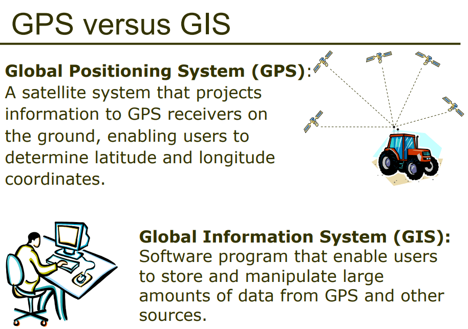
GPS and GIS are examples of contemporary mapping tools that rely on ______ technology.

a)

remote sensing/satellite

b)

computer

c)

smart phone/satellite

d)

International Space Station

36.
These terms are the four ways that geographers determine
a)
location
b)
place
c)
scale
d)
global grid
37.
Applying the Five Themes, a geographer would identify this image as a  _____ region; these countries have established, widely-agreed on borders .
a)
formal/uniform
b)
functional/nodal
c)
perceptual/vernacular
38.
Applying the Five Themes, a geographer would know this San Antonio Via bus route map depicts a  _____ region.
a)
formal/uniform
b)
functional/nodal
c)
perceptual/vernacular
39.
Applying the Five Themes, a geographer would say this postcard depicts Texas as a  collection of _________ regions.
a)
formal/uniform
b)
functional/nodal
c)
perceptual/vernacular
40.
The world's earliest maps were used as 
a)
reference tools
b)
communication tools
41.
Meaning, "to take care of," ______ is also what we care about.
a)
culture
b)
history
c)
landmarks
d)
place
42.

Depicts what an individual knows about a place, containing personal impressions of what is in a place and where places are located and is not based upon any actual measurement.

a)

mental map

b)

thematic map

c)

reference map

43.

Used by geographers in thinking why each region on Earth is distinctive, it is a body of customary beliefs, material traits, and social forms that together constitute the distinct tradition of a group of people.

a)

biome

b)

culture

c)

possibilism

d)

environmental determinism

44.

The geographic study of human-environmental relationships.

a)

cultural ecology

b)

ecological culture

45.

The notion that the physical environment may limit some human actions, but people have the ability to adjust to their environment – example, people choose to plant crops which are more likely to be productive in their given region.

a)

environmental determinism

b)

possibilism

c)

culture

d)

biome

46.

The five classifications geographers use for climate – A Tropical Climates, B Dry Climates, C Warm Mid-Latitude Climates, D Cold Mid-Latitude Climates, E Polar Climates

a)

Doppen System

b)

Koppen System

c)

Broppen System

47.

Forest, Savanna, Grassland, and Desert are the four major _____________, or forms of plant communities, which are influenced by climate and human activities.

a)

biomes

b)

climates

c)

ecosystems

48.

What happened to the Everglades in Florida causing great environmental damage such as heavy pollution and loss of habitat for wildlife.

a)

Humans dammed the water for agriculture

b)

Humans opening up more land for sugarcane farming

c)

Humans built suburbs on these fragile areas

d)

All of these happened

49.

The Dutch use of polders to drain and use land THAT IS BELOW SEA LEVEL is a good example of

a)

environmental determinism

b)

possibilism

50.

Why are the Netherlands seen as being "sensitive" to their impact on the environment and contributing to climate change?

a)

They are returning lowlands to natural areas

b)

They are reducing fertilizer use

c)

They have converted to mostly renewable energy

d)

All of the above

51.

Geographers are concerned with soil erosion and depletion of nutrients which are cause by.....

a)

deforestation

b)

heavy use of chemicals in agriculture

c)

planting more water intensive and chemical dependent crops

d)

All of these

52.

These maps show the importance of changing _____________ in understanding something (like cancer rates in the US)

a)

regions

b)

scale

c)

site

53.

From a spatial perspective (maps) what became clear about WHO was most negatively impacted by Hurrican Katrina BEFORE and AFTER the floods.

a)

Hispanics

b)

Whites

c)

African Americans

d)

Native Americans

54.

A phenomenon by which the experience of everyday life, as influenced by the diffusion of commodities and ideas, reflects a standardization of cultural expressions around the world.

a)

cultural globalization

b)

regionalization

c)

economic globalization

d)

individualism

55.

The diminishing in importance and eventual disappearance of a phenomenon with increasing distance from its origin

a)

distance decay

b)

globalization

c)

regionalization

d)

nodalism

56.

180 degrees Longitude is known as the ...

a)

equator

b)

Prime Meridan

c)

International Date Line

d)

North Pole

57.

0 degrees latitude is known as the

a)

Equator

b)

Prime Meridian

c)

International Date Line

d)

North Pole

58.

The Prime Meridian is ________________________.

a)

180 degrees Longitude.

b)

0 degrees Latitude

c)

0 degrees Longitude

d)

90 degrees Latitude

59.

A location on the Earth's surface with a distinctive characteristic

a)

place

b)

diffusion

c)

network

d)

environment
