wayground logo

Free Printable Worksheets

Font size

S
M
L
XL
Worksheets

Geologic Processes

Total questions: 99

Worksheet time: 3hrs 16mins

Name
Class
Date
1.

What is the process of moving sediments from location to another?

a)

Deposition

b)

Erosion

c)

Weathering

d)

Compaction

2.

The process of breaking up Earth's surface into sediment is called...

a)

sediment

b)

erosion

c)

weathering

d)

deposition

3.

What is sediment?

a)

the process of rocks being broken down and carried away

b)

bits of rock, sand, and silt caused by the weathering of rocks

c)

the top layer of the soil

d)

decaying plant or animal material

4.

Which of these is an example of erosion

a)

Light Shining onto a mountain

b)

Rain breaking down rock

c)

Wind blowing away sediment

d)

All of the above

5.
What happens when weathering and erosion work together?
a)
New Mountains are created
b)
The climate changes overnight
c)
Metal objects become rusty
d)
They change the Earth's surface
6.
The process that breaks down rocks and other materials on Earth's surface is called
a)
weathering
b)
erosion
c)
soil conservation
d)
decomposition
7.
What is the major cause of weathering and erosion to form canyons?
a)
wind
b)
ice
c)
glaciers
d)
moving water
8.
What is the correct order of the processes?
a)
they all happen at the same time
b)
erosion, weathering, deposition
c)
weathering, erosion, deposition
d)
weathering, deposition, erosion
9.
How do plants weather rocks?
a)
during photosynthesis
b)
when roots grow into cracks of rocks and expand the rock
c)
when the plant moves water from the roots to the leaves
d)
Plants don't weather rocks
10.
The ___________of a mountain weathers the fastest
a)
bottom
b)
middle
c)
top
d)
all parts weather the same
11.
Which agents  break down earth materials?
a)
wind only
b)
earthquakes and gravity
c)
ice and 007
d)
wind, water, and ice
12.
What is an enormous mass of ice moving over land?
a)
Ice wedging
b)
Glacier
c)
Iceberg
d)
Dune
13.

Deltas are mainly created by the process of -

a)

deposition

b)

weathering

c)

waves

d)

erosion

14.
Rain washing away soil from a hillside
a)
Weathering
b)
Erosion
c)
Deposition
15.
Wind blowing sand from one location to another
a)
Weathering
b)
Erosion
c)
Deposition
16.
An avalanche is an example of which process?
a)
Weathering
b)
Erosion
c)
Deposition
d)
Volcanic Eruption
17.
Over long periods of time, deposition may change the Earth’s surface by _____.
a)
forming new land features.
b)
breaking down large rocks into smaller ones.
c)
washing away beaches.
d)
moving topsoil.
18.
A cliff formed near the ocean.  Which statement best describes how this cliff formed?
a)
Warm air melted the rock.
b)
Sun rays evaporated the rock.
c)
Ocean waves washed away rock.
d)
Plant roots pushed away the rock.
19.
Deposition changes the Earth’s surface because bits of broken rock and soil _____.
a)
stop rivers from flowing.
b)
make rich farmlands.
c)
are dropped in new places.
d)
move very slowly.
20.
What causes the greatest erosion effect on our beaches?
a)
Waves
b)
Gravity
c)
Glaciers
d)
Wind
21.
Which of these is an example of erosion?
a)
Light shining onto a mountain.
b)
Rain breaking down rocks on a mountain into smaller pieces. 
c)
Wind blowing away sediment to a new place on the mountain.
d)
All of the above.
22.
Layers of sediment forming at the bottom of the ocean floor is an example of
a)
Weathering
b)
Erosion
c)
Deposition
d)
Awesome Science
23.
Muddy water being carried away by a fast-moving river is an example of
a)
Weathering
b)
Erosion
c)
Deposition 
d)
A nice place to swim
24.
Which of the following is NOT a slow change to Earth's surface?
a)
Weathering
b)
Erosion
c)
Deposition
d)
Landslides
25.
Which of the following is NOT a fast change in Earth's surface?
a)
Landslides
b)
Erosion
c)
Volcanoes Erupting
d)
Earthquakes
26.

Erosion is most likely greatest at locations

a)

A and B

b)

B and C

c)

C and D

d)

D and A

27.

The landscape feature labeled X is best described as

a)

Floodplain

b)

Delta

c)

Sandbar

d)

Escarpment

28.

Which event is the best example of erosion?

a)

breaking apart of shale as a result of water freezing in a crack

b)

dissolving of rock particles on a limestone gravestone by acid rain

c)

rolling of a pebble along the bottom of a stream

d)

crumbling of bedrock in one area to form soil

29.

The choices below represent stages in the formation of a meandering river. Which sequence best represents the usual changes over time?

a)
b)
c)
30.

Where is the most deposition likely to occur?

a)

on the side of a sand dune facing the wind

b)

at the mouth of a river, where it enters an ocean

c)

at a site where glacial ice scrapes bedrock

d)

at the top of a steep slope in a streambed

31.

Sediment is deposited as a river enters a lake because the

a)

velocity of the river decreases

b)

force of gravity decreases

c)

volume of water increases

d)

slope of the river increases

32.

The cross section below shows a V-shaped valley and the bedrock beneath the valley.

Which agent of erosion is responsible for cutting most V-shaped valleys into bedrock?

a)

surface winds

b)

glacial ice

c)

running water

d)

ocean waves

33.

The diagram represents a meandering stream flowing into the ocean. Letter C indicates a triangular-shaped depositional feature where the stream enters the ocean.

The triangular-shaped depositional feature indicated by letter C is a

a)

Floodplain

b)

Delta

c)

Ellipse

d)

Water Table

34.
The shape of the land is shown by connecting points of the same elevation to form a ____________.
a)
relief line
b)
slope
c)
valley
d)
contour line
35.
Contour lines that are very close together indicate the land is _______________
a)
gentle/gradual
b)
a forest
c)
steep
d)
a swamp
36.
Contour lines that are very far apart indicate the landscape is _____________
a)
gentle/gradual
b)
steep
c)
a forest
d)
a swamp
37.
What could be the lowest elevation in the depression?
a)
50 feet
b)
41 feet
c)
60 feet
d)
51 feet
38.
Determine the contour interval:
a)
5 m
b)
10 m
c)
15 m
d)
20 m
39.
Determine the contour interval:
a)
5 m
b)
10 m
c)
15 m
d)
20 m
40.
What do close contour lines represent on a map?
a)
waterfall
b)
steep area
c)
gradual area
d)
river
41.
Which direction is the river flowing?
a)
north
b)
south
c)
east 
d)
west
42.
How many mountain peaks are represented?
a)
one
b)
two
c)
three
d)
four
43.
What could be the elevation of the mountain top?
a)
860 km
b)
840 km
c)
841 - 859 km
d)
861 - 869 km
44.
Match 1 
a)
A
b)
B
c)
C
d)
D
45.
Match 2
a)
B
b)
C
c)
D
d)
E
46.
Match 4
a)
C
b)
D
c)
E
d)
F
47.
An area's height above sea level
a)
topography 
b)
relief
c)
elevation
d)
GIS
48.
Find the contour interval:
a)
5 ft
b)
10 ft
c)
20 ft
d)
25 ft
49.
What is the elevation of point B?
a)
800 ft
b)
850 ft
c)
900 ft
d)
1000 ft
50.
Determine the contour interval
a)
10 m
b)
20 m
c)
50 m
d)
100 m
51.
What is the elevation of Y?
a)
Between 120-140 meters
b)
Between 100-120 meters
c)
Between 140-160 meters
d)
Between 80-100 meters
52.
What is the elevation at sea level?
a)
0
b)
100m
c)
20m
d)
3000m
53.
What is the elevation of point B? (Contour interval is 100m)
a)
800 ft
b)
850 ft
c)
900 ft
d)
1000 ft
54.
A mountaineer is planning an expedition. He wants to follow the easiest possible path, which means he needs to find the most gentle slope up the mountain. Which route should the mountaineer choose?
a)
Route A
b)
Route B
c)
 Route C
d)
Route D
55.
How many mountain tops does this map have?
a)
one
b)
two
c)
three
d)
four
56.
What process created this V-shaped valley?
a)
Erosion due to a river
b)
Erosion due to a glacier
c)
Weathering due to a river
d)
Weathering due to wind
57.
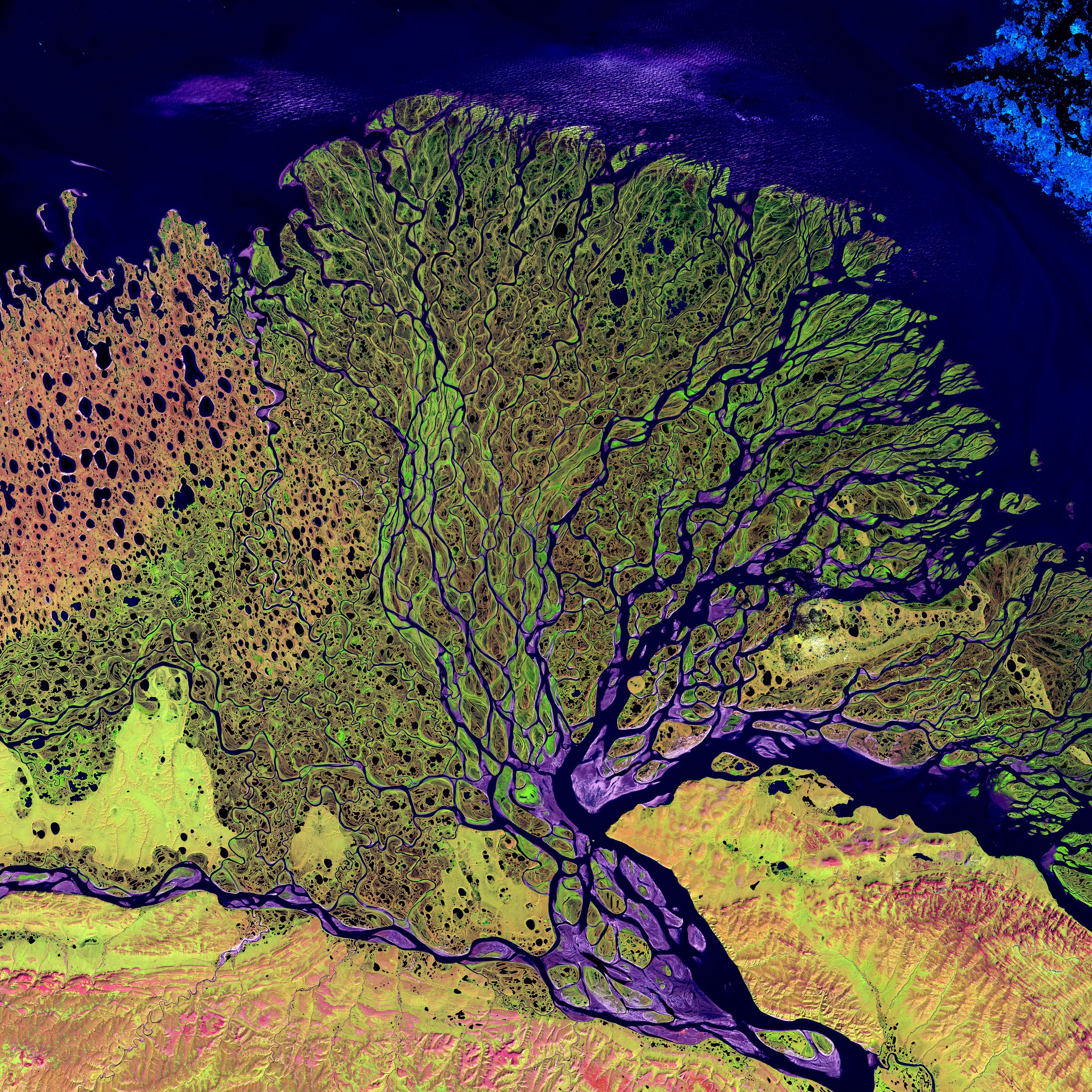
The type of formation shown is at the southern end of the Mississippi river. What is it called?
a)
coastal erosion
b)
a delta
c)
a loess
d)
sand dunes
58.
Most earthquakes occur near...
a)
state boundaries
b)
plate boundaries
c)
country boundaries
d)
rivers
59.
A mountain range is an example of which type of plate boundary movement?
a)
Divergent
b)
Transform
c)
Convergent
60.
The type of plate boundary where two plates come together is a .....
a)
Convergent Boundary
b)
Divergent Boundary
c)
Transform Boundary
d)
Plate Boundary
61.
Which of the following causes Earth's tectonic plates to move?
a)
Energy from the Sun
b)
Magnetic Pole Reversal
c)
Convection currents in the mantle
d)
Faults in Mountain Ranges
62.
What type of plate boundary is this?
a)
Plate
b)
Divergent
c)
Convergent
d)
Transform
63.
What type of event will occur at this boundary?
a)
Earthquake
b)
Volcano Eruption
c)
Tornado
d)
Mountain Building
64.
A divergent boundary occurs when plates ....
a)
Pull apart
b)
Come together
c)
Slide past each other
d)
subducting
65.
Which of the following is the name of the ancient supercontinent formed 28 Million Years ago.
a)
Pangea
b)
Gondwanda
c)
Laurasia
d)
Neverland
66.
Which of the following is NOT evidence to support the theory of plate tectonics?
a)
Fossils
b)
Mountains
c)
Glaciers
d)
Sand Erosion
67.
The theory that says Earth's continents once made up an ancient supercontinent, and have been drifting apart ever since, is called the theory of...
a)
Pangea
b)
Plate Tectonics
c)
Natural Selection
d)
Gravity
68.
Oceanic Trenches are formed by _______ plate boundaries
a)
Convergent
b)
Transform
c)
Plate
d)
Divergent
69.
How is it possible for new crust to be formed without increasing the surface area of the Earth?
a)
Crust is destroyed at the same time it is created
b)
New crust is underwater where it sinks
c)
New crust breaks more easily than old crust
70.

A gigantic mass of moving ice

a)

glacial drift

b)

stratified drift

c)

till

d)

glacier

71.

unsorted rock material deposited directly by ice as it melts

a)

glacial drift

b)

stratified drift

c)

till

d)

glacier

72.
This force causes the movement of glaciers
a)
pressure
b)
ice age
c)
gravity
d)
firn
73.
Till deposited in the front of a glacier
a)
ground moraine
b)
lateral moraine
c)
terminal moraine
d)
medial moraine
74.
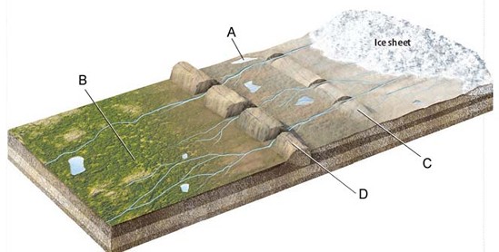
What glacial features are indicated by the labels C and D on the figure?
a)
moraines
b)
outwash plains
c)
kettle lakes
d)
ice sheets
75.
What is the opening in Earth's crust through which molten rock, gases, and ash erupt?
a)
Divergent Boundary
b)
Magma
c)
Subduction Boundary
d)
Volcano
76.
Why does magma tend to rise to the surface?
a)
It has large amounts of silica.
b)
It contains very little silica.
c)
It is denser than the surrounding material.
d)
It is less dense than the surrounding material.
77.
The volcanoes on the Hawaiian Islands form due to which of the following?
a)
Divergent Boundary
b)
Hot Spot
c)
Subduction Boundary
d)
Transform Boundary
78.
Where do volcanoes come from?
a)
Places where plates move apart
b)
Places where plates are moving together
c)
Hot Spots
d)
All of these options
79.
What is the shaking of the Earth’s crust caused by a release of energy?
a)
Earthquake
b)
Epicenter
c)
Fault
d)
Plate
80.
Which of the following is NOT a cause of an earthquake?
a)
Collapse of Cavern
b)
Eruption of Volcano
c)
Lightning Strikes
d)
Moving Tectonic Plates
81.
Which type of wave is the first to arrive after an earthquake occurs?
a)
P Wave
b)
Rayleigh Wave
c)
S Wave
d)
Shear Wave
82.
What occurs when water flows or collects over land that is usually dry.
a)
dam
b)
flood
c)
floodway
d)
levee
83.

There are both hot and cold deserts.

a)

true

b)

false

84.

_________________ rates are faster than rainfall rates which keep the desert very dry.

a)

Sun

b)

Evaporation

c)

Condensation

85.
What best describes the climate in the desert?
a)
warm
b)
hot
c)
dry
d)
windy
86.

Which of the following would classify as a desert?

a)

warm temperatures with few animals

b)

warm temperatures with many animals

c)

less than 25 centimetres of rain per year

d)

more than 25 centimetres of rain per year

87.
Continental glaciers...
a)
cover millions of square miles
b)
do not cover an entire land mass
c)
carve out cirques and arretes
d)
are responsible for U-shaped valleys
88.
When a glacier is experiencing more melting than snow accumulation it is said to be in a period of _____.
a)
glacial drift 
b)
glacial retreat 
c)
glacial advance 
d)
o  glacial outburst 
89.
How do glaciers erode land?
a)
By picking up soil and rocks and depositing them in new location
b)
By picking up water from lakes and streams and carrying it to the ocean
c)
By causing rain and snow in an area
d)
By lowering the atmospheric pressure, causing intense windstorms
90.
How were the Great Lakes formed?
a)
Canadians built a series of dams, making huge reservoirs
b)
Glaciers carving the land during the Ice Age, then melting
c)
Water flowing in from the Atlantic Ocean
d)
Underground springs
91.

which type of moraine forms along each side of a glacier?

a)

medial moraine

b)

lateral moraine

c)

ground moraine

d)

terminal moraine

92.

Name two kinds of glaciers

a)

Continental Glaciers and valley glaciers

b)

Eroson Glaciers

c)

Mud slide

93.

Kettle

a)

small depression formed by a chunk of ice when it melts

b)

ridges formed at the edge of a glacier

94.
What is a bowl-shaped depression formed by glacial erosion?
a)
cirque
b)
arrete
c)
ice pack
d)
kettle
95.
The deposit at the furthest point the glacier ever gets.
a)
moraine
b)
ground moraine
c)
recessional moraine
d)
terminal moraine
96.
What happens when layers of snow keep piling up?
a)
The bottom layers are compressed into ice
b)
The top layers melt into water
c)
The top layers are compressed into ice
d)
The bottom layers melt into water
97.

Scratches in rocks caused by glaciers are called...

a)

Horn

b)

drumlin

c)

Striations

d)

Kettle

98.

What feature is labeled A in Figure 7-1?

a)

kame

b)

esker

c)

drumlin

d)

end moraine

99.
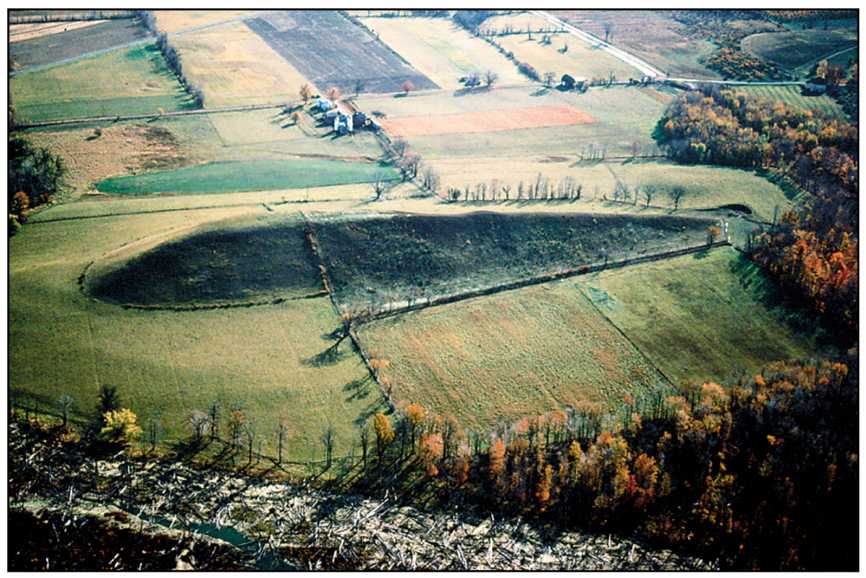
A _____ is a tear-drop-shaped hill created by ice flow over and around till deposit.
a)
drumlin
b)
esker
c)
moraine
d)
erratic