wayground logo

Free Printable Worksheets

NEW

Font size

S
M
L
XL
Worksheets

Plate Tectonics/Topographic Maps Review

Total questions: 58

Worksheet time: 5hrs 48mins
Name
Class
Date
1.

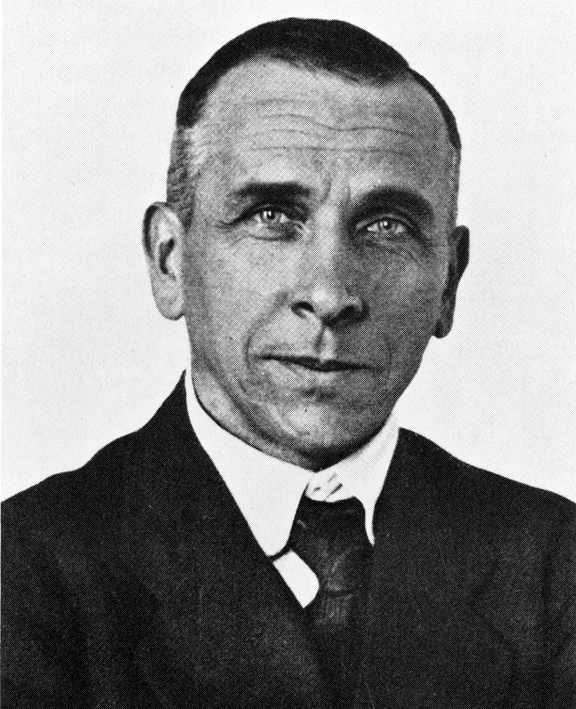
Who is the person credited with developing the theory of continental drift?

a)

Harry Hess

b)

Galileo

c)

Alfred Wegener

d)

Issac Newton

2.
What does the theory of continental drift state?
a)
The continents were once joined in a super-continent and have moved over time
b)
Continents are stationary and do not move
c)
The Earth is broken into lithospheric plates that move due to convection currents
d)
none of the above
3.
What evidence did Wegener use in his theory?
a)
Continents and fossils fitting together/matching-up like puzzle pieces 
b)
glacier scars and evidence from temperature
c)
mountain ranges and coal deposits line up across continents
d)
all of the above
4.
Why did no one believe Wegener's thoery?
a)
He could not explain HOW the continents moved
b)
He didn't have evidence
c)
His data was wrong
d)
He didn't use the right technology to gather data
5.
What are the two types of crust?
a)
continental and oceanic
b)
ocean and basin
c)
lower and upper
d)
thick and thin
6.
What drives tectonic plate movement? 
a)
gravity
b)
coriolis effect
c)
convection currents
d)
the earth's magnetic core
7.
Earthquakes and volcanoes are most likely found in which locations? 
a)
at plate boundaries
b)
in oceans
c)
in the middle of continents
d)
in the middle of plates
8.
When an oceanic plate and a continental plate collide, which one will subduct? 
a)
oceanic
b)
continental
c)
neither
d)
both
9.
What is Pangaea?
a)
the name of a German scientist
b)
the name of the super-continent that existed millions of years ago
c)
another name for continental drift
d)
the name of an ancient fossil
10.
In Seafloor Spreading, molten material rises from the mantle and erupts or flows out 
a)
along the edges of all the continents
b)
along mid-ocean ridges
c)
in the deep ocean trenches
d)
in the north and south poles
11.
The geological theory that states that pieces of Earth's lithosphere are in constant, slow motion is the theory of
a)
subduction
b)
plate tectonics
c)
evolution
d)
seafloor spreading
12.
The process by which the ocean floor sinks beneath a deep ocean trench and back into the mantle is known as
a)
convection
b)
continental drift
c)
subduction
d)
conduction
13.
A place where two plates slide past each other, moving in opposite directions, is known as a
a)
transform boundary
b)
divergent boundary
c)
convergent boundary
d)
rift valley
14.
A rift valley forms at a 
a)
convergent plate boundary
b)
divergent plate boundary
c)
transform boundary
d)
deep ocean trench
15.
A collision between two pieces of continental crust at a converging boundary produces a 
a)
mid-ocean ridge
b)
deep ocean trench
c)
volcanic mountain range
d)
folded mountain range
16.
Oceanic crust is.....
a)
Younger and less dense than continental crust
b)
Thinner, younger, and more dense than continental crust
c)
older, thicker, and less dense than continental crust
d)
Bigger and younger than continental crust
17.
Earth's plates are....
a)
Constantly moving and changing the face of the Earth
b)
Never moved
c)
Move seldom and very fast
d)
move when they feel like it
18.

Whenever a subduction zone is formed a ____ is formed.

a)

mountain

b)

Island arc

c)

rift valley

d)

volcano

19.
Plate movement is caused by _____
a)
The rotation of the Earth
b)
Ocean tides
c)
Convection current in the mantle
d)
The moon's gravity
20.

Created by a divergent boundary

a)

rocky mountain

b)

Mariana's Trench

c)

mid-Atlantic ridge

d)

volcano

21.
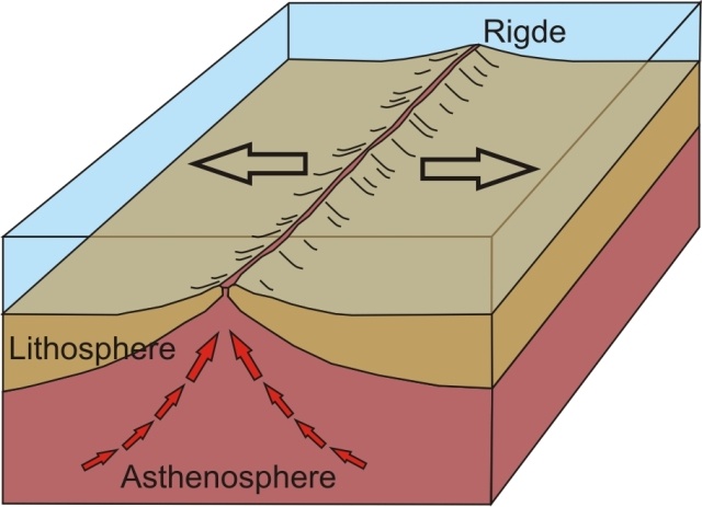
What kind of plate boundary is shown here?
a)
divergent
b)
convergent
c)
transform
d)
subducting
22.
What kind of plate boundary is shown here?
a)
divergent
b)
convergent
c)
transform
d)
strike slip
23.
What type of event will occur at this boundary?
a)
Earthquake
b)
Volcano Eruption
c)
Tornado
d)
Mountain Building
24.
A divergent boundary occurs when plates ....
a)
Pull apart
b)
Come together
c)
Slide past each other
d)
subducting
25.
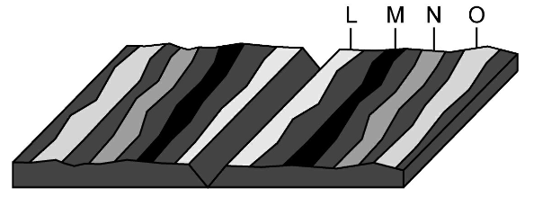
Where would the oldest rock be found?
a)
L
b)
M
c)
N
d)
O
26.
A fault is formed by the movement of a __________ plate boundary
a)
Transform
b)
Convergent
c)
Divergent
27.
What is the elevation of point B?
a)
800 ft
b)
850 ft
c)
900 ft
d)
1000 ft
28.
What is the elevation of the peak of the small island on the left side?
a)
About 20 meters
b)
About 40 meters
c)
About 60 meters
d)
About 200 meters
29.

What feature is formed at B?

a)

river

b)

rift valley

c)

sink hole

d)

mountain

30.
What feature is at the arrow?
a)
volcano
b)
mountain
c)
cliff
d)
river
31.
Determine the contour interval:
a)
5 m
b)
10 m
c)
15 m
d)
20 m
32.
What do contour lines that are farther apart represent?
a)
waterfall
b)
steep area
c)
gentle slope
d)
river
33.
What is the difference in elevation between Point X and Point Y?
a)
120 m
b)
240 m
c)
360 m
d)
340 m
34.
Provided is a topographic map of a hill with contour lines drawn showing elevation in meters.
The steepest slope on this hill can be found on the side that is facing which direction?
a)
Southwest
b)
Northeast
c)
Northwest
d)
Southeast
35.
What would be the most likely way this coastline would change over time?
a)
A fire could destroy the vegetation
b)
The waves could erode the beach
c)
The beach would grow due to deposition
d)
The beach will disappear due to plate tectonics
36.
These images compare the same stretch of coastline.  What is a possible reason for the change?  
a)
A fire destroyed the beach and surrounding area
b)
Overtime, water eroded away much of the land
c)
A major catastrophe such as a hurricane or tsunami destroyed the area
d)
The beach and land went through a sever drought
37.
A satellite image of an area in Florida shows a river with slight bends along its length. A second satellite image taken of the same area 10 years later shows the same river with  a different course. What is the best explanation for the difference in the shape of the river's course between the two satellite images?
a)
Wind blew waves across the water surface, eroding away the bank on one side of the river until the river's course changed its shape
b)
Regular freezing and thawing of the river split the soil along the river banks, changing the shape of the river
c)
Water eroded the banks of the river and deposited the eroded soil on opposite banks, causing the river to form tighter bends
d)
Acid rain chemically weathered the banks along the river, forcing the river to wind back and forth
38.
The image below represents a satellite view. What type of land features are pictured in this image?
a)
canyons
b)
hills
c)
rivers
d)
volcanoes
39.
What is the profile view to Topographic Map #1? 
a)
A
b)
B
c)
C
d)
D
40.
What is the profile view to Topographic Map #2?
a)
B
b)
C
c)
D
d)
E
41.
The process by which water, ice, wind or gravity moves weathered rock and soil from one place to another.
a)
weathering
b)
erosion
c)
deposition
d)
dumptruck
42.

Waves dropping sand on the beach is an example of what?

a)

Weathering

b)

Erosion

c)

Deposition

d)

Compaction

43.

The process of breaking up rocks on Earth's surface is known as what?

a)

sediment

b)

erosion

c)

weathering

d)

deposition

44.
As you were climbing a mountain, you noticed that rocks were crumbling below your feet and moving down the mountain. What 2 processes did you observe?
a)
Weathering and erosion
b)
Erosion and deposition
c)
Abrasion and chemical weathering
d)
Abrasion and ice wedging
45.

Your teacher filled a box with sand. He put a fan at one end and turned the fan on. The sand was blown to the opposite side of the box and collected at that side. What processes was the teacher demonstrating?

a)

Weathering and erosion

b)

Weathering and deposition

c)

Erosion and deposition

d)

Chemical and mechanical weathering

46.
Determine the contour interval:
a)
5 m
b)
10 m
c)
15 m
d)
20 m
47.

A fan shaped area where a river enters a larger body of water such as an ocean or lake is called a -

a)

Delta

b)

Canyon

c)

Coastline

d)

Dune

48.

Which area would experience the most erosion from waves?

a)

A

b)

B

c)

C

d)

D

49.

Which of the following factors carves out canyons through the processes of weathering and erosion?

a)

Water

b)

Wind

c)

Roots

d)

Gravity

50.

What can hold on to soil to prevent soil erosion?

a)

Plants and trees

b)

Animals and humans

c)

Rocks and logs

d)

Gravity

51.

What does arid mean?

a)

Dry

b)

Moist

c)

Humid

d)

Cold

52.

Dunes are mounds of sand that are created by -

a)

Strong winds

b)

Warm ocean water

c)

Precipitation such as rain, snow and sleet

d)

Gravity

53.

The satellite image shows a ship channel between South Padre Island and Boca Chica beach in South Texas.

Sand is sometimes removed from the ship channel through a process called dredging to make it easier for ships to travel through. Recently sand from the bottom of the channel was moved to area beaches. Without this transfer of sand, what would most likely occur in this area in the future?

a)

The ship channel would become deeper, and the island would move west toward the mainland.

b)

The ship channel would become shallower, and the beach would become narrower.

c)

The ship channel would become narrower, and the island would become completely covered with water.

d)

The ship channel would become wider, and the island would sink into the Gulf of Mexico.

54.

Which of the following best describes how mountains change over time?

a)

The elevation of the peaks will decrease due to erosion.

b)

The elevation of the peaks will increase due to weathering.

c)

The elevation of the peaks will increase due to deposition.

d)

Mountains stay the same, they never change.

55.

This is a satellite image of the Houston Ship Channel. Which point on this image will experience the most erosion?

a)

A

b)

B

c)

C

d)

D

56.

This is a meteor crater. Which of the following is a prediction of how the crater will change over the next 1,000 years?

a)

The crater will become more shallow as the sides erode into the center.

b)

The crater will become deeper as animals make the crater home and burrow deep into the rock.

c)

The crater will not change over 1,000 years.

d)

The crater will fill in with lava.

57.
The Great Rift Valley in Africa and the Mid-Ocean Ridge were all created by this boundary
a)
Divergent
b)
Convergent
c)
Reform
d)
Transform
58.

What is the contour interval in this topographic map?

a)

40 m

b)

20 m

c)

35 m

d)

50 m