wayground logo

Free Printable Worksheets

Font size

S
M
L
XL
Worksheets

Weather Review End of Unit

Total questions: 83

Worksheet time: 2hrs 33mins

Name
Class
Date
1.
What are the two main factors that determine the climate of an area?
a)
precipitation and humidity
b)
temperature and air pressure
c)
wind conditions and humidity
d)
temperature and precipitation
2.
What are the 3 major climate zones in order from equator to the poles?
a)
polar, temperate, tropical
b)
tropical, temperate, polar
c)
temperate, polar, tropical
3.
Which sentence best describes the relationship between elevation and air temperatures?
a)
LOWER elevation = COLDER temperatures
b)
HIGHER elevation = COLDER temperatures
c)
HIGHER elevations = WARMER temperatures
4.
The temperature of a tropical climate is?
a)
consistently warm
b)
consistently cool
c)
consistently moderate
d)
warm and cool
5.
A polar climate is?
a)
warm and cool
b)
consistently moderate
c)
consistently cool
d)
consistently warm
6.
A temperate climate is?
a)
consistently cool
b)
consistently warm
c)
consistently moderate
d)
warm and cool
7.
The temperate zones of the Earth are between the tropics. Is that true or false? 
a)
True
b)
False
8.

What climate zone is the red area in the picture?

a)

Polar zone

b)

Temperate zone

c)

Tropical zone

9.

What climate zone is the white area in the picture?

a)

Polar zone

b)

Temperate zone

c)

Tropical zone

10.
In an ocean, warm water moves __________ and cold water moves ____________.
a)
Down, Up
b)
Up, Down
11.
What causes wind?
a)
movement of high pressure to low pressure
b)
movement of low pressure to high pressure
12.
During convection, more dense currents _________ and less dense currents _________.
a)
sink, rise
b)
rise, sink
13.
The curving path of a moving object from an otherwise straight path due to Earth's rotation is called what?
a)
Sublimation
b)
Continental Deflection
c)
Transpiration
d)
Coriolis Effect
14.
Which one heats and cools fastest?
a)
land
b)
sea
c)
both are the same rate
d)
air
15.
The main reason that we have currents in the ocean and air is
a)
the sun heats the air and ocean evenly everywhere
b)
the heat inside the earth heats the ocean and the ocean heats the air
c)
the sun cannot heat both the air and water, so one must heat the other
d)
the sun heats air and water more at the equator because it receives more direct sunlight
16.
What type of winds blow constantly, predictably, and over long distances?
a)
land breezes
b)
mountain breezes
c)
global winds
d)
land breezes
17.
Where does the initial source of energy come from that creates winds?
a)
the moon
b)
the sun
c)
the Earth's surface
d)
the rotation of the Earth
18.

What is the initial source for global winds and convection in the atmosphere?

a)

heat from the Earth's core

b)

the rotation of the Earth

c)

Moon's gravity

d)

unequal heating of the Earth by the sun

19.
Which diagram shows the formation of a land breeze?
a)
diagram Y
b)
diagram X
c)
neither 
d)
both
20.
Which diagram shows the formation of a sea breeze?
a)
diagram Y
b)
diagram X
c)
neither
d)
both
21.
Which statement correctly describes the properties of cold air?
a)
less dense and less pressure than warm air
b)
more dense and more pressure than warm air
c)
more dense and less pressure than warm air
d)
less dense and more pressure than warm air
22.
Near the top of the troposphere is a narrow band of high speed winds called the______.
a)
westerlies
b)
jet stream
c)
trade winds
d)
local winds
23.
What kind of breeze is this and when would it form?
a)
Land breeze - daytime
b)
Land breeze - nighttime
c)
Sea breeze - daytime
d)
Sea breeze - nighttime
24.
In which direction do prevailing westerlies flow?
a)
from east to west
b)
from west to east
c)
from north to south
d)
from south to north
25.
Which global winds are found at the poles? 
a)
Polar Westerlies
b)
Prevailing Easterlies
c)
Polar Easterlies
d)
Trade Winds
26.
Which global winds directly effect weather in the U.S.?
a)
Trade Winds
b)
Prevailing Westerlies
c)
Polar Easterlies
d)
Doldrums
27.
The tropical winds running from 0 to 30 degrees latitude are called:
a)
subtropical westerlies
b)
polar westerlies
c)
trade winds
d)
polar winds
28.

Which part of Earth gets a lot of direct sunlight?

a)

tropical

b)

polar

c)

temperate

29.
What causes wind?
a)
convection currents
b)
conduction currents
c)
radiation currents
d)
tropical currents
30.
What is the instrument called that measures air pressure?
a)
thermometer
b)
ruler
c)
yard stick
d)
barometer
31.
When air is heated, it will MOST likely
a)
expand and fall
b)
expand and rise
c)
condense and fall
d)
condense and rise
32.

How do jet streams affect weather?

a)

They move air that is different temperatures to new locations

b)

They keep air in the tropical zone.

c)

They keep air in the polar zone.

d)

They have little effect on weather.

33.

What is the jet stream?

a)

Precipitation in North Carolina

b)

Weather over a long period of time

c)

Strong winds above the Earth's surface

d)

Football flying over the Earth

34.

A narrow band of fast moving winds high in the atmosphere that move from west to east

a)

Jet Stream

b)

doldrums

c)

equator

d)

polar easterlies

35.
Which has the greatest effect on the movement of the jet stream? 
a)
size of clouds
b)
amount of precipitation
c)
differences in air temperatures
36.
How does the jet stream affect the weather?
a)
The jet stream transports weather systems that affect us.
b)
The jet stream does not affect the weather.
c)
The jet stream releases oxygen so we can breathe.
d)
The jet stream brings only bad weather.
37.

What will most likely result when the jet stream moves south of North

Carolina?

a)

North Carolina will experience tropical weather conditions.

b)

North Carolina will experience hot, dry weather.

c)

North Carolina will experience mild weather.

d)

North Carolina will experience cold weather.

38.

Which country would Great Britain’s climate be most like if the Gulf Stream and the Labrador Current did not exist?

a)

South Africa

b)

South America

c)

Canada

d)

Antarctica

39.

Which best explains what type of weather the Gulf Stream usually brings

to North Carolina?

a)

increased wind speed

b)

increased air pressure

c)

increased temperature

d)

increased evaporation

40.
How does the Gulf Stream affect weather conditions along the eastern coast of the United States?
a)
The Gulf Stream causes temperatures to decrease.
b)
The Gulf Stream causes temperatures to increase.
c)
The Gulf Stream causes more overcast skies.
41.

Which country would Great Britain’s climate be most like if the Gulf Stream and the Labrador Current did not exist?

a)

South Africa

b)

South America

c)

Canada

d)

Antarctica

42.
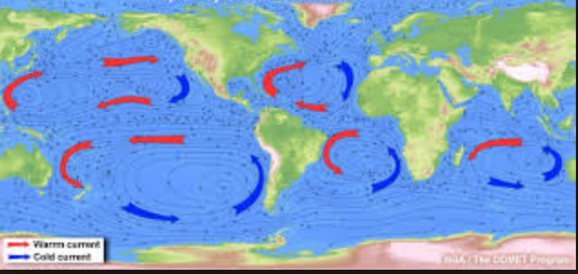
Analyze the image. What could explain why certain parts of the ocean have warmer temperatures?
a)
the uneven heating of the Earth's surface
b)
the rising of cold air and the sinking of warm air
c)
hurricanes
43.
Which current affects the west coast?
a)
California Current
b)
Gulf Stream Current
c)
Caribbean Sea Current
44.
Which current affects the east coast?
a)
California Current
b)
Gulf Stream Current
c)
Caribbean Sea Current
45.
Analyze the map.
Why is it colder in San Diego than it is in Charleston even though they are the same distance from the Equator?
a)
San Diego is affected by the Gulf Stream
b)
Charleston is affected by the California current
c)
San Diego is affected by the California Current
46.
Analyze the map.
Why is it warmer in Charleston than it is in San Diego even though they are the same distance from the Equator?
a)
San Diego is affected by the Gulf Stream
b)
Charleston is affected by the California current
c)
Charleston is affected by the Gulf Stream
47.
Why don't hurricanes affect the west coast?
a)
the water on the coast of California is too shallow to sustain a hurricane
b)
the water on the coast of California is too warm to sustain a hurricane
c)
the water on the coast of California is too cold to sustain a hurricane
48.

Describe the air on the windward side of a mountain.

a)

dry

b)

hot

c)

moist

d)

cold

49.

Describe the air on the leeward side of a mountain.

a)

cold

b)

warm

c)

dry

d)

moist

50.

The leeward side of the mountain in in the

a)

rain shadow

b)

way

c)

river

d)

rainbow

51.

Which side of the mountain usually gets deserts and why?

a)

windward, because of rising, moist air

b)

leeward, because of rising, dry air

c)

windward, because of sinking, moist air

d)

leeward, because of sinking, dry air

52.

Low pressure systems are associated with

a)

clear skies

b)

clouds

53.
Low pressure will usually bring what kind of weather?
a)
Sunny
b)
Calm
c)
Stormy
54.
High pressure will usually bring what kind of weather?
a)
clear and dry
b)
cloudy and wet
55.
Based on the information in the table, in which city will it most likely rain?
a)
City W
b)
City X
c)
 City Y
d)
City Z
56.
_______ pressure systems are characterized by fair weather.
a)
High
b)
Low
57.
Michael observes the air pressure daily. Over the last couple of days the air pressure has been dropping. What weather will Michael most likely observe as a result?
a)
increasingly clear skies and more wind
b)
increasingly clear skies and dry weather
c)
increasingly cloudy skies and possible storms
58.
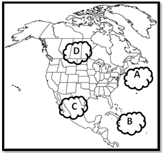
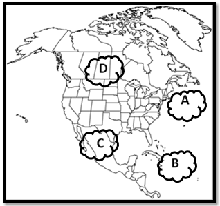
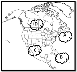
Which type of air would you find at air mass A?
a)
cold, dry
b)
warm, humid
c)
warm, dry
d)
cold, humid
59.
Which type of air would you find at air mass B?
a)
cold, dry
b)
warm, humid
c)
warm, dry
d)
cold, humid
60.
Which type of air would you find at air mass C?
a)
cold, dry
b)
warm, humid
c)
warm, dry
d)
cold, humid
61.
Which type of air would you find at air mass D?
a)
cold, dry
b)
warm, humid
c)
warm, dry
d)
cold, humid
62.
A hurricane rotates _____.
a)
Clockwise
b)
Counterclockwise 
63.

The major difference between a tropical storm and a hurricane is __________.

a)

rainfall amounts

b)

wind speed

c)

air temperature

64.
Hurricanes develop in ________ regions.
a)
Arctic
b)
Tropical
c)
Arid
d)
None of the above
65.
Where do most hurricanes develop?
a)
Middle of the United States
b)
Near the Equator
c)
Near Canada and Alaska
d)
Antarctica
66.

Hurricanes ______ over land.

a)

strengthen

b)

weaken

67.

Air pressure _________ the closer you get to Earth's surface.

a)

increases

b)

decreases

68.

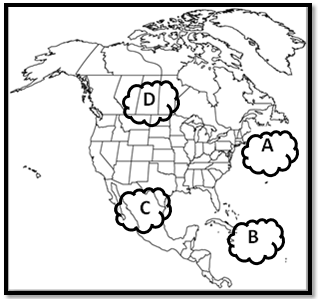
What climate zone does Location A represent?

a)

Polar

b)

Temperate

c)

Tropical

69.

What climate zone does Location B represent?

a)

Polar

b)

Temperate

c)

Tropical

70.

What climate zone does Location C represent?

a)

Polar

b)

Temperate

c)

Tropical

71.

Climate shows ___________ data and weather shows _______ data.

a)

long term; short term

b)

long term, long term

c)

short term, long term

d)

short term, short term

72.
What symbol is this?
a)
warm front
b)
cold front
c)
stationary front
d)
occluded front
73.
a)
Low Clouds
b)
Low Temperatures
c)
Light Wind
d)
Low Air Pressure
74.
a)
High Air Pressure
b)
High Temperatures
c)
Heavy Rain
d)
Hail
75.
a)
High Air Pressure
b)
High Temperatures
c)
Heavy Rain
d)
Hail
76.
a)
High Pressure
b)
Warm Front
c)
Cold Front
d)
Mountains
77.
Air pressure is greatest:
a)
closer to Earth
b)
farther from Earth
78.
Is this a land or a sea breeze?
a)
land breeze
b)
sea breeze
79.
The picture represents the symbol for a _______________________Front.
a)
Cold
b)
Warm
c)
Occluded
d)
Stationary
80.

Which of the follow would account for a decrease in global temperatures?

a)

cutting back on fossil fuel use

b)

limiting deforestation (cutting down trees)

c)

several major volcanic eruptions

d)

teaching villages about how too many farm animals can increase temperatures

81.

Dry Bulb 12 C Wet Bulb 5 C

a)

88

b)

76

c)

54

d)

43

82.

This graph represents a...

a)

tropical rainforest

b)

temperate rainforest

c)

tropical desert

d)

polar desert

83.

What influences weather the most?

a)

solar energy

b)

clouds

c)

ice in polar regions

d)

heat from the burning of fossil fuels