
 Worksheets
Review ES 2020
Total questions: 170
Worksheet time: 3hrs 21mins

The outermost layer is the ________.
mantle
crust
inner core
outer core

The core is made up mostly of _______________.
oxygen
magnesium
iron
carbon

The second abundant element that makes up the core is ______________.
nickel
iron
oxygen
calcium

The rock type that makes up Oceanic Crust is __________.
granite
conglomerate
basalt
gold

The rock type that makes up continental crust is ____________________.
copper
silver
basalt
granite
The latitude of the observer can be determined by measuring the altitude of Polaris because Earth has a
nearly spherical shape
nearly circular orbit around the Sun
variable length of day
fairly constant period of revolution
Which diagram best represents the location of Polaris for an observer located at the Equator?


Base your answer on the map, which shows the latitude and longitude of five observers, A, B, C, D and E, on Earth. What is the altitude of Polaris (the North Star) above the northern horizon for observer A?
0o
10o
80o
90o
How can we describe an oblate spheroid?
Equatorial Diameter is shorter than the Polar Diameter
Polar Diameter is shorter than the Equatorial Diameter
Polar and Equatorial Diameter are equal
The line that marks zero degrees LATITUDE is called
The Equator
The Tropic of Cancer
The Prime Meridian
The Tropic of Capricorn
All lines of LONGITUDE are called
North and Souths
Parallels
Meridians
Tropics

What are the coordinates of Buffalo, New York?
43° N, 79.° W
42.9° N, 78.8° E
78° N, 43° W
42.9° N, 78.8° W

The diagram shows an observer on Earth measuring the altitude of Polaris. What is his latitude?
43° N
43° S
47° N
47° S


Sedimentary rocks form from
Compaction and Cementation
Melting and Solidifcation
Weathering and Erosion
Heat and Pressure
Sediments are formed from
Compaction and Cementation
Weathering and Erosion
Melting and Solification
Heat and Pressure
Igneous rocks w/ small or no crystals are classified as ____.
extrusive
intrusive
foliated
nonfoliated
________ igneous rocks have large crystals
Extrusive
Intrusive
Clastic
Foliated
The process in which rocks are continually being formed, broken down, moved, and reformed is known as:
the rock cycle
crystallization
erosion
deposition
What do the properties of minerals depend on?
where it is found
structural unit or arrangement of atoms
temperature
heat and pressure
Divergent boundaries occur when...
tectonic plates move toward one another
tectonic plates move beside one another
tectonic plates move underneath one another
tectonic plates move away from one another
The idea that there was once one massive supercontinent that broke apart and moved individual continents across the ocean is known as?
Pangaea
Continental drift
Plate tectonics
Laurasia

The movement of matter due to differences in density is known as?
convection
sea-floor spreading
plate tectonics
earthquakes
Places on Earth, away from tectonic plate boundaries, that volcanoes can still form due to magma under the surface and pressure are called?
volcanoes
hot spots
boundaries
faults
The point within the Earth where the earthquake originates.
epicenter
fault
focus
strike-slip
What large wave is triggered by an earthquake that occurs on the ocean floor?
tsunami
hang ten
oceanic wave
earthquake wave


A student hiking in a rock area on a mountain notices that wide, deep cracks have formed in some of the large rocks. Some of the cracks are so large that the rocks have broken apart. Which process most likely caused these rocks to crack and creak?
Erosion by wind
Water freezing and thawing
Erosion by fast-moving
Sediments being deposited.
Which is the #1 Agent of Erosion in NYS?
Gravity
Rivers
Glaciers
Wind
What is the shape of the particles found in a river?
Round
Angular
Square
Triangular
What is the name of the elongated hills that are left behind by a glacier?
Moraines
Erratics
Drumlins
Kettle Lakes
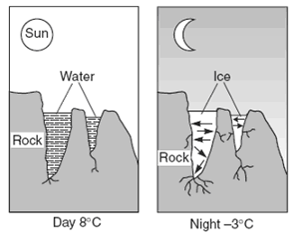
Which statement best explains why this process results in weathering?

Would the sediments in this feature be sorted or unsorted by size?
sorted
unsorted

What agent of erosion created this landscape feature?
Stream
Glacier
Wind
Wave

This diagram is showing the formation of a glacial feature. Which feature is indicated by the arrow?
Ox-bow Lake
Kettle Lake
Cut banks
Moraine
Chatter Marks

What is the shape of this valley and what must have formed it?
U-shaped and glacier
U-shaped and stream
V-shaped and glacier
V-shaped and stream
What is the largest particle size that can be transported by a stream moving 20 cm/sec?
2.0 cm
200.0 cm
0.4 cm
0.2 cm

What agent of erosion deposited this boulder?
Stream
Glacier
Wind
Wave

What would be the correct term for the ridges on Long Island labelled as "A" and "B"?
drumlins
moraines
outwash plains
kettles
barrier island

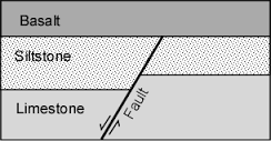
Electromagnetic waves vary in
the speed they travel in a vacuum.
wavelength and frequency.
the way they reflect.
the orientation of their electric and magnetic fields.
The waves with the longest wavelengths in the electromagnetic spectrum are
Infrared rays.
radio waves
gamma rays
X-rays
The visible light spectrum ranges between
radar waves and X-rays.
television waves and infrared rays.
infrared rays and ultraviolet rays.
ultraviolet rays and gamma rays.
Which of the following occurs as a light wave bends when it passes from one medium into another?
constructive interference
refraction
destructive interference
reflection


Which of the following is not a method for heat transfer
Radiation
Insulation
Conduction
Convection
In which of the following state are the particles closest together?
Fluid
Gas
Liquid
Solid
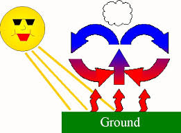
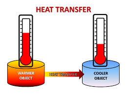
Which two properties characterize an air mass?
temperature and size
temperature and pressure
temperature and moisture
moisture and pressure
Polar air masses form
Only in water
At high latitudes
Only in winter
At low latitudes

Which weather condition is measured by this instrument?
air humidity
air pressure
wind direction
wind speed

Which motion do the arrows in the diagram represent?
Earth’s rotation
Earth’s revolution
the Sun’s rotation
the Sun’s revolution


**think about where the salt water is**


The curved paths of the planetary winds are a result of

The unequal heating rates of the land and water are caused by
land having a higher density than water
water having a higher density than land
land having a higher specific heat than water
water having a higher specific heat than land


How often do we experience new seasons?
Monthly
Yearly
Every 3 months
Every 6 months
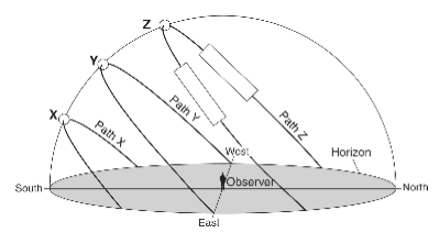
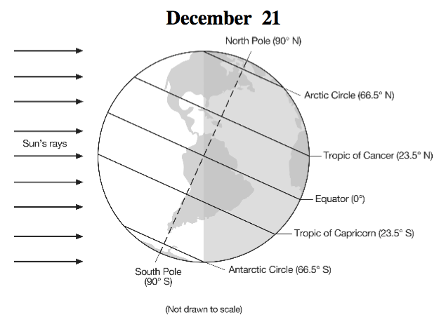
When is an observer's shadow the longest?
when the sun is rising or setting
when the sun is directly overhead
when it is nighttime
Which type of land surface will most likely absorb the greatest amount of incoming solar radiation?
rough, dark-colored surface
rough, light-colored surface
smooth, dark-colored surface
smooth, light-colored surface
A swinging pendulum that appears to change direction in a predictable manner.
Coriolis Effect
Heliocentric
Geocentric
Foucault Pendulum
Winds and ocean currents bend from their expected path.
Foucault Pendulum
Coriolis Effect
Heliocentric
Geocentric
The first day of summer or the Summer Solstice.
June 21
March 21
September 21/23
December 21
The first day of Winter or the Winter Solstice.
June 21
March 21
September 21/23
December 21
The first day of Spring or the Vernal Equinox.
June 21
March 21
September 21/23
December 21
The first day of Fall or the Autumnal Equinox.
June 21
March 21
September 21/23
December 21
A solar system model that placed Earth in the center.
Geocentric
Heliocentric
Aphelion
Perihelion
A solar system model that placed the Sun in the center.
Geocentric
Heliocentric
Aphelion
Perihelion


Wha type of tide would this arrangement of earth-moon-sun create?
full moon tide
new moon tide
neap tide
spring tide


