
 Worksheets
Plate Tectonics Topo Satellite Review
Total questions: 58
Worksheet time: 44mins
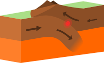

Folded mountains are created when....
Two continental plates collide
Two oceanic plates pull apart
An Oceanic plate subducts under a Continental Plate
Two continental plates pull apart
What are the lines called on topographic map?
Curved lines
Distance lines
Contour lines
Squiggly lines

What is the contour interval in this topographic map?
40 m
20 m
35 m
50 m

What is the highest point on this topo map?
600
400
500
608

What is the contour interval in this topographic map?
275 m
150 m
250 m
300 m


Which topographic map matches this profile?


The topographic map shows a canyon. At which point does the canyon have the least change in elevation?
A
B
C
D
The topographic map shows a canyon. At which point does the canyon have the greatest change in elevation?
A
B
C
D

Which profile best represents the contour map along line AB?


The satellite image below shows a ship channel between South Padre Island and Boca Chica beach in South Texas.
Sand is sometimes removed from the ship channel through a process called dredging to make it easier for ships to travel through. Recently sand from the bottom of the channel was moved to area beaches. Without this transfer of sand, what would most likely occur in this area in the future?
The ship channel would become deeper, and the island would move west toward the mainland.
The ship channel would become shallower, and the beach would become narrower.
The ship channel would become shallower, and the beach would become narrower.
he ship channel would become wider, and the island would sink into the Gulf of Mexico.
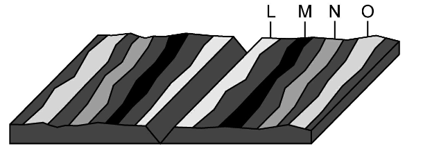
Convection currents in the mantle are a driving force of tectonic movement. At which location do the convection currents cause the plates to diverge?
strike-slip fault
subduction zone
mid-ocean ridges
folded mountains

A geologic cross section of the Himalayan Mountain Range is shown. This mountain range is the result of which type of boundary interaction?
divergent boundary between two continental plates
convergent boundary between two continental plates
divergent boundary between a continental plate and an oceanic plate
convergent boundary between a continental plate and an oceanic plate

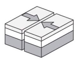
Two tectonic plates are shown. Geologists predict that folded mountains will form in about 10 million years.
Which best explains the motion of the tectonic plates?
Plate 1 and Plate 2 are moving east.
Plate 1 and Plate 2 are moving west.
Plate 1 is moving west and Plate 2 is moving east.
Plate 1 is moving east and Plate 2 is moving west.

The diagram shows two plates of crust on Earth moving away from each other. Which event will most likely occur at Point A?
An eroded mountain will rise.
Magma will form new crust in the form of a mid ocean ridge.
A freshwater lake will develop.
Rivers will form a canyon.

Which profile below reflects this topographic map?


Which profile below reflects this topographic map?

Which profile below reflects this topographic map?

Which profile below reflects this topographic map?

This topographic map represents the elevation of an area a 100 years ago. At that time the highest point had an elevation of 214m. The highest point has since eroded a total of 7m. Which profile most likely represents the landscape today?


The satellite image shows a portion of the Namib Desert in Africa. This is an ancient, sandy desert with dunes that can be up to 305 m tall. The Namib Desert extends inland from the Atlantic Ocean between 80 km and 200 km and receives only 5 mm to 76 mm of rain each year. A satellite picture of this same area taken weeks before shows that the shape and location of some sand dunes have changed. Which of these most likely caused the changes in the dunes?
Ocean waves
Flowing rivers
Blowing wind
Crustal uplift

This satellite photograph shows an area in Alaska after a fire occurred. Which statement best describes the most likely effect the fire had on the river in the 12 months after it occurred?
Less sediment flowed into the river because the fire heated up the soil and made it drier.
The amount of vegetation increased and less sediment flowed into the river because the fire produced ash that mixed with the soil.
More sediment flowed into the river because the fire destroyed most of the vegetation holding the sediment in place.
More sediment flowed into the river because the fire disrupted animal habitats and caused animals ot leave the area.

A student stands at the point marked X on the topographic map below. What height in meters must the student climb in order to reach the top of the hill?
248
253
303
355

The photograph shows mountains in the Andes range in South America. Which statement describes the geologic process that is most likely responsible for the formation of these mountains?
They are along a transform plate boundary that is no longer active, so erosion is creating deep valleys.
They are along a transform plate boundary in which plates are currently moving side by side, causing earthquakes and faults.
They are along a plate boundary in which plates are currently converging, causing uplift and steep slopes.
They are along a plate boundary in which plates diverged in the distant past, allowing new rock to build up.
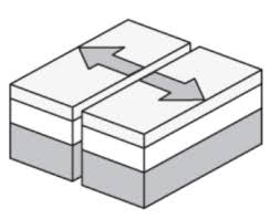
A mid-ocean ridge is located at the boundary of two tectonic plates. Which diagram correctly models the relative plate motion on each side of a mid-ocean ridge?


Rift valleys can form when fractures in Earth's crust widen. The valley walls slowly move at a rate of only a few millimeters a year. Which of these best describes the type of tectonic activity that forms rift valleys?
Rift valleys form where a continental plate moves under an oceanic plate
Rift valleys form where a plate slides horizontally past another plate
Rift valleys form where two plates move away from each other
Rift valleys form where an oceanic plate moves under another oceanic plate

