wayground logo

Free Printable Worksheets

Font size

S
M
L
XL
Worksheets

Regents Review Week 2: Climate, Climate Change, Erosion

Total questions: 146

Worksheet time: 4hrs 24mins

Name
Class
Date
1.
DAY 031 CW (p.153)
 
( T or F ) A city close to the ocean will tend to have a summer and winter temperature that are close together.
a)
True 
b)
False
2.
DAY 031 CW (p.153)
 
( T or F ) Cities far from a large body of water like the ocean will tend to have very different temperatures in the summer and winter. 
a)
True 
b)
False
3.
DAY 031 CW (p.153)
 
( T or F ) The Labrador Current is a cold current that carries water toward the equator. 
a)
True 
b)
False
4.
DAY 031 CW (p.153)
 
( T or F ) The east side of S. America is warmed by an ocean current traveling from the equator.
a)
True 
b)
False
5.
DAY 031 CW (p.153)
 
Which surface ocean current transports warm water to higher latitudes? 
a)
Gulf Stream
b)
 Labrador Current 
c)
Falkland Current 
d)
West Wind Drift 
6.
DAY 031 CW (p.153)
 
Identify the surface ocean current that prevents the formation of coral reefs in the shallow waters along the western coast of South America. [1] 
a)
Peru Current
b)
Brazil Current
c)
Falkland Current 
d)
South Equatorial Current
7.
DAY 031 CW (p.153)
The graph below shows the average monthly temperatures for two cities, A and B, which are both located at 41° north latitude.  
 
Which statement best explains the difference in the average yearly temperature range for the two cities?
 
a)
City B is located near a large body of water. 
b)
City B is located in a different planetary wind belt.
c)
City B receives less yearly precipitation.
d)
City B has a greater yearly duration of insolation.
8.
DAY 031 Exit Task (p.154)
Which two 23.5°-latitude locations are influenced by cool surface ocean currents?        
a)
the east coast of North America and the west coast of Australia
b)
the west coast of North America and the west coast of South America
c)
the west coast of Africa and the east coast of South America
d)
the east coast of Asia and the east coast of North America 
9.
DAY 031 Exit Task (p.154)
The Canaries Current along the west coast of Africa and the Peru Current along the west coast of South America are both         
a)
warm currents that flow away from the Equator
b)
cool currents that flow toward the Equator
c)
warm currents that flow toward the Equator
d)
cool currents that flow away from the Equator
10.
REVIEW DAY Bonus Question (handout)
The map shows a portion of the western United States and Canada. Two cities in Canada, Vancouver and Winnipeg, are labeled on the map.   
 
Which graph best represents the average monthly air temperatures for Vancouver and Winnipeg? 
a)
warm currents that flow away from the Equator
b)
cool currents that flow toward the Equator
c)
warm currents that flow toward the Equator
d)
cool currents that flow away from the Equator
11.
REVIEW DAY Bonus Question (handout)
Which ocean current has the greatest warming influence on the climate of the Outer Banks of North Carolina? (North Carolina is along the southeastern coast of the United States). 
 
HINT: You need to use ESRT (H)
a)
North Atlantic Current 
b)
Gulf Stream Current
c)
Labrador Current 
d)
Canary Current 
12.
REVIEW DAY Bonus Question 
Explain using the data to the left why EurekaIt is probably closer to a large body of water. 

HINT: See p. 148 for a hint.
a)
It has less variation over the course of the year in temperature.
b)
It has more variation over the course of the year in temperature.
c)
It has no variation over the course of the year in temperature.
d)
None of these
13.
REVIEW DAY Bonus Question 

Which statement best explains the climate variation between these two cities?

a)
City A is located far inland, and city B is 
      located near a large body of water. 
b)
City A is located at a high elevation, and 
      city B is located at sea level.
c)
City A and city B are located at the same   
      longitude.
d)
City A is located on the east coast, and 
      city B is located on the west coast. 
14.
DAY 028 CW (p.129)
 
( T or F ) Areas with dry climate belts have sinking, condensing air
a)
True 
b)
False
15.
DAY 028 CW (p.129)
 
( T or F ) An area with a latitude of 30°S is likely to have very little precipitation all year long. 
a)
True 
b)
False
16.
DAY 028 CW (p.129)
 
( T or F ) High pressure regions near the equator cause air to rise and form clouds.
a)
True 
b)
False
17.
DAY 028 CW (p.129)
 
( T or F ) Areas near 60°N is likely to have cold, dry climate all year long.
a)
True 
b)
False
18.
DAY 028 CW (p.129)
 Dry areas caused by sinking air and diverging surface winds are located at which two latitudes? 
a)
0° and 30°N
b)
30°N and 30°S
c)
0° and 60°S
d)
60°N and 60°S 
19.
DAY 028 CW (p.129)
A high air-pressure, dry-climate belt is located at which Earth latitude? 
a)
15°N
b)
30°N
c)
0° 
d)
60°N 
20.
DAY 028 CW (p.129)
It can be concluded that city C is located in the Southern Hemisphere because city C has
a)
small amounts of precipitation throughout the year
b)
its warmest temperatures in January and February
c)
large amounts of precipitation throughout the year
d)
its warmest temperatures in July and August 
21.
DAY 028 Exit Task (p. 130) 
What evidence shown on the graph indicates that city X is located in the Southern Hemisphere? [1] 
a)
The highest temperatures of the year happen in Jan/Feb.
b)
The lowest temperatures of the year happen in Jan/Feb.
c)
The highest temperatures of the year happen in June/July.
d)
None of these
22.
DAY 028 Exit Task (p. 130) 
State whether the climate of city X is dry or wet. Then, determine the most likely location of city X. 
 
HINT: Use ESRT X for this.
a)
Wet - 60°N
b)
Dry - 30°S
c)
Wet - 60°S
d)
Dry - 30°N
23.
DAY 028 Exit Task (p. 130) 
Which graph best represents the average monthly temperatures for one year at a location in the Southern Hemisphere?
a)
Graph 1
b)
Graph 2
c)
Graph 3
d)
Graph 4
24.
DAY 029 CW (p.137)
Planetary winds and ocean currents are deflected* in the Northern and Southern Hemispheres due to
 
*HINT: 
[deflected = curved] 
             
a)
plate tectonics
b)
the Coriolis effect
c)
the Doppler effect 
d)
seasonal changes 
25.
DAY 029 CW (p.137)
( T or F ) Winds that blow at 15°S latitude generally blow from the northeast. 
a)
True
b)
False
26.
DAY 029 CW (p.137)
( T or F ) Winds that blow at 40°N latitude generally blow from the southwest.
a)
True
b)
False
27.
DAY 030 CW (p.145)
( T or F ) Mountains cause air traveling over them to rise up and cool to the dewpoint, causing rain.
a)
False
b)
True
28.
DAY 030 CW (p.145)
( T or F ) The side of the mountain that the wind comes from is called the leeward side. 
a)
False
b)
True
29.
DAY 030 CW (p.145)
( T or F ) The side of the mountain that receives less rainfall is called the windward side. 
a)
False
b)
True
30.
DAY 030 CW (p.145)
( T or F ) Once air travels over a mountain it warms up and the climate becomes very wet.
a)
False
b)
True
31.
DAY 030 Exit Task (p. 146) 
Identify one labeled latitude on this continent where a high-pressure zone exists and dry air is sinking to the surface. Include both the unit and compass direction in your answer.
a)
30°N
b)
45°N
c)
d)
60°S
32.
DAY 030 Exit Task (p. 146) 
Identify one factor that causes a colder climate at location B than at location A. [1] 
a)
B is high in the mountains.
b)
Winds are going in a different direction at B.
c)
B is on the equator.
d)
B is low in the mountains.
33.
DAY 030 Exit Task (p. 146) 
Explain why location C has a warmer and drier climate than location D. 
a)
It is on the leeward side of a mountain range
b)
It is on the windward side of a mountain range
c)
It is closer to the equator
d)
The Coriolis effect causes this
34.
Which geographic area is a common source region for cP air masses that move into New York State? 
a)
southwestern United States 
b)
central Canada
c)
the north Pacific Ocean
d)
the Gulf of Mexico
35.
Compared to a maritime tropical air mass, a maritime polar air mass has a 
a)
higher temperature and more water vapor 
b)
higher temperature and less water vapor
c)
lower temperature and more water vapor 
d)
lower temperature and less water vapor
36.
Base your answers to this question on the cross section shown, which shows two weather fronts moving across New York State. Lines X and Y represent frontal boundaries. The large arrows show the general direction the air masses are moving. The smaller arrows show the general direction warm, moist air is moving over the frontal boundaries.
Which type of front is represented by letter X?
   
a)
cold front
b)
warm front
c)
occluded front
d)
stationary front
37.
Which combination of climate factors generally results in the warmest temperatures? 
a)
low elevation and low latitude 
b)
low elevation and high latitude 
c)
high elevation and low latitude 
d)
high elevation and high latitude
38.
Base your answers to this question on the map shown, which shows Earth’s planetary wind belts.
Which climatic conditions exist where the prevailing southwesterlies and the polar easterlies converge? 
a)
cool and wet 
b)
cool and dry 
c)
warm and wet 
d)
warm and dry
39.
The cross section below represents prevailing winds moving over a coastal mountain range. Letters A through D represent locations on Earth’s surface.
Which location will most likely have the least annual precipitation? 
a)
b)
B
c)
C
d)
D
40.
The data table shown compares the climates of two United States cities located at approximately 43° north latitude. The data are based on a 30-year period. 
Which statement best explains the climate variation between these two cities?
a)
City A and city B are located at the same   
      longitude
b)
City A is located at a high elevation, and 
      city B is located at sea level.
c)
City A is located far inland, and city B is 
      located near a large body of water.
d)
City A is located on the east coast, and 
      city B is located on the west coast.
41.
DAY 025 CW 
(p. 113) Which type of front is located between Buffalo and Detroit? 
a)
stationary
b)
cold
c)
warm
d)
occluded
42.
DAY 025 CW (p. 113)
( T or F ) The air mass behind a cold front in our area is warmer than the air it replaces. 
a)
False
b)
True
43.
DAY 025 CW (p. 113)
( T or F ) When drawing a cold or warm front, the symbols go on the side that the front is coming from.
a)
False
b)
True
44.
DAY 027 CW (p. 121)
( T or F ) The two climate variables that appear on most climate graphs are precipitation and temperature averages by month.
a)
False
b)
True
45.
DAY 027 CW (p. 121)
( T or F ) The bar graph on the climate graph is precipitation, and it is measured in degrees Celsius
a)
False
b)
True
46.
DAY 027 CW (p. 121)
( T or F ) Whenever the warmest month happens on a climate graph is summer for that location.
a)
False
b)
True
47.
DAY 025 CW 
(p. 113)
Which cross section best represents the frontal boundary (fb) and general pattern of air movements between locations C and D? 
a)
Diagram (1)
b)
Diagram (2)
c)
Diagram (3)
d)
Diagram (4)
48.
DAY 025 CW (p. 113)
(T or F)  A cold front forms where a cold air mass is replacing a warmer air mass.
a)
False
b)
True
49.
DAY 027 Exit Task 
(p. 122) During which season does city B usually experience the month with the highest average precipitation?
a)
winter
b)
spring
c)
summer
d)
fall
50.
DAY 027 Exit Task 
Which of the following is true according to the climate graphs above.    
a)
The two cities have the highest precipitation around the same time.
b)
The two cities have the lowest precipitation around the same time.
c)
None of these.
d)
The two cities have the highest temperature around the same time.
51.

DAY 038 CW (p. 202)

How does an increase in carbon dioxide (CO2) and water vapor (H2O gas) content of Earth’s atmosphere affect climate?

a)

It cools climate, because of more infrared absorption.

b)

It warms climate, because of more infrared absorption.

c)

It cools climate, because of less infrared absorption.

d)

It warms climate, because of less infrared absorption.

52.
DAY 038 CW (p.201)
 
( T or F ) Two major gases from volcanoes are oxygen and nitrogen.
a)
True
b)
False
53.
DAY 038 CW (p.201)
 
( T or F ) The atmosphere of the Earth is largely believed to have originated from early volcanoes. 
a)
True
b)
False
54.
DAY 038 CW (p.201)
 
Most scientists believe Earth’s Early Archean atmosphere was formed primarily by gases released from
a)
stream erosion 
b)
volcanic eruptions
c)
chemical weathering
d)
the addition of ash particles into the 
plant transpiration
55.
DAY 037 CW (p.193)
 
Explain how increasing the amount of greenhouse gases in Earth’s atmosphere increases global temperatures. Your answer must include the term, infrared.
a)
Increasing greenhouse gases keeps more infrared from escaping into space.
b)
Increasing greenhouse gases causes more infrared to escape into space.
c)
Increasing greenhouse gases keeps more infrared from escaping into the atmosphere.
d)
Increasing greenhouse gases causes more infrared to escape into the atmosphere.
56.
DAY 037 CW (p.193)
 
Explain how the effect of global warming on present-day continental glaciers (Large pieces of ice) could affect New York City and Long Island. 
a)
It will cause the glaciers to freeze, drying up NYC and Long Island
b)
It will cause the glaciers to freeze, flooding NYC and Long Island
c)
It will cause the glaciers to melt, drying up NYC and Long Island
d)
It will cause the glaciers to melt, flooding NYC and Long Island
57.
DAY 037 CW (p.193)
 
Increasing the amount of carbon dioxide in Earth’s atmosphere increases atmospheric temperature because the carbon dioxide absorbs 
a)
incoming solar gamma ray radiation
b)
 incoming solar visible light radiation
c)
outgoing terrestrial ultraviolet radiation 
d)
outgoing terrestrial infrared radiation
58.
DAY 037 CW (p.193)
 
( T or F ) With an enhanced greenhouse effect, areas near the oceans will be most affected by flooding.
a)
True
b)
False
59.
DAY 037 CW (p.193)
 
( T or F ) Short-wavelength energy is allowed to pass through the greenhouse gases, but long-wavelength energy is trapped. 
a)
True
b)
False
60.
DAY 037 CW (p.193)
 
( T or F ) During the greenhouse effect, greenhouse gases absorb and re-emit long-wavelength radio waves.
a)
True
b)
False
61.
DAY 035 HW (p.170)
 
How does increasing the amount of greenhouse gases in Earth’s atmosphere increase global temperatures.
a)
It causes the atmosphere to absorb more infrared radiation.
b)
It causes the atmosphere to reflect more infrared radiation.
c)
It causes the atmosphere to absorb more ultraviolet radiation.
d)
It causes the atmosphere to reflect more ultraviolet radiation.
62.
DAY 035 HW (p.170)
 
Identify one major greenhouse gas that contributes to global warming. 
a)
nitrogen
b)
nitrous oxide
c)
oxygen
d)
hydrogen
63.
DAY 035 HW (p.170)
 
An increase in which gas would cause the most greenhouse warming of Earth’s atmosphere?
a)
nitrogen
b)
carbon dioxide
c)
oxygen
d)
hydrogen
64.

DAY 035 CW (p.169)

An increase in which gas in Earth’s atmosphere will LEAST significantly increase global temperatures?

a)

methane

b)

carbon dioxide

c)

oxygen

d)

water vapor

65.
DAY 035 CW (p.169)
 
Which two gases have been added to Earth’s atmosphere in large amounts and are believed to have increased global warming by absorbing infrared radiation?
a)
methane and carbon dioxide 
b)
hydrogen and helium
c)
chlorine and nitrogen
d)
neon and argon
66.
DAY 035 CW (p.177)
 
( T or F ) Without any greenhouse gases, the Earth would be too warm for life to exist.
a)
True
b)
False
67.
DAY 035 CW (p.177)
 
( T or F ) Water vapor and methane are two other greenhouse gases. 
a)
True
b)
False
68.
DAY 035 CW (p.177)
 
( T or F ) Greenhouse gases are only natural gases that warm the Earth. 
a)
True
b)
False
69.
DAY 034 CW (p.169)
 
Which pie graph correctly shows the percentage of elements by volume in Earth’s troposphere?

 
a)
Graph 1
b)
Graph 2
c)
Graph 3
d)
Graph 4
70.
DAY 036 CW (p.185)
 
( T or F ) The electromagnetic spectrum is all the different forms of sound energy, from lowest to highest energy.
a)
True 
b)
False
71.
DAY 036 CW (p.185)
 
( T or F ) Visible light has a shorter wavelength than radio waves. 
a)
True 
b)
False
72.
DAY 036 CW (p.185)
 
( T or F ) Energy with a long wavelength has more energy than energy with a short wavelength. 
a)
True 
b)
False
73.
DAY 036 CW (p.185)
 
( T or F ) Earth is a source of infrared radiation, which it emits into space.
a)
True 
b)
False
74.
DAY 036 CW (p.185)
 
Which conclusion is best supported by the diagram?
a)
All types of electromagnetic energy reach Earth’s surface. 
b)
Gamma rays and x rays make up the greatest amount of electromagnetic energy reaching Earth’s surface.
c)
Visible light makes up the greatest amount of electromagnetic energy reaching Earth’s surface.
d)
Ultraviolet and infrared radiation make up the greatest amount of electromagnetic energy reaching Earth’s surface. 
75.
DAY 036 CW (p.185)
 
Most of the electromagnetic energy radiated from Earth’s surface is in the form of 
a)
ultraviolet rays
b)
gamma rays
c)
infrared rays
d)
x-rays
76.
DAY 036 CW (p.185)
 
Which type of radiation from Earth is the long-wave radiation absorbed by greenhouse gases
a)
ultraviolet
b)
visible light
c)
infrared
d)
radio waves
77.
DAY 036 CW (p.186)
 
What is the basic difference between ultraviolet, visible, and infrared radiation? 
a)
half-life
b)
temperature
c)
wavelength
d)
wave velocity
78.
BONUS (ESRT Y)
 
Which energy on the electromagnetic spectrum is heat energy?
a)
infrared
b)
visible light
c)
ultraviolet
d)
gamma rays
79.
BONUS (ESRT Y)
 
Which energy on the electromagnetic spectrum is dangerous for humans?
a)
infrared
b)
visible light
c)
radio waves
d)
gamma rays
80.
BONUS (ESRT Y)
 
Which energy on the electromagnetic spectrum has a short wavelength?
a)
infrared
b)
visible light
c)
radio waves
d)
gamma rays
81.
BONUS (ESRT Y)
 
Which energy on the electromagnetic spectrum has the longest wavelength?
a)
blue light
b)
green light
c)
yellow light
d)
red light
82.
BONUS (ESRT Y)
 
Some x ray wavelengths are between the wavelengths of 
a)
visible light and microwaves
b)
microwaves and visible light
c)
ultraviolet and infrared
d)
gamma rays and ultraviolet
83.
BONUS (ESRT Y)
 
Some microwave wavelengths are between the wavelengths of 
a)
visible light and ultraviolet
b)
microwaves and visible light
c)
radio waves and infrared
d)
gamma rays and ultraviolet
84.
BONUS (ESRT Y)
 
Which list is in order of DECREASING WAVELENGTH
a)
ultraviolet, radio waves, gamma rays
b)
microwaves, ultraviolet, x rays
c)
ultraviolet, gamma rays, radio waves
d)
gamma rays, visible light, microwaves
85.

(2) Day 34:

An increase in which gas in Earth’s atmosphere will most significantly increase global temperatures?

a)

nitrogen

b)

methane

c)

oxygen

d)

hydrogen

86.

(3) DAY 35:

Base your answers to the question below on the diagram, which represents the greenhouse effect in which heat energy is trapped in Earth’s atmosphere.


Which type of radiation from Earth is the long-wave radiation absorbed by greenhouse gases?

a)

ultraviolet

b)

infrared

c)

visible light

d)

radio waves

87.

(4) DAY 35:

Which part of the Sun’s electromagnetic spectrum has the shortest wavelength?

a)

radio wave radiation

b)

infrared radiation

c)

visible light radiation

d)

x-ray radiation

88.

(5) DAY 36:

The diagram shows a greenhouse.

What is the primary function of the clear glass of the greenhouse?

a)

The glass reduces the amount of insolation entering the greenhouse.

b)

The glass allows all wavelengths of radiation to enter and all wavelengths of radiation to escape.

c)

The glass allows long wavelengths of radiation to enter, but reduces the amount of short- wavelength radiation that escapes.

d)

The glass allows short wavelengths of radiation to enter, but reduces the amount of long- wavelength radiation that escapes.

89.

(8) DAY 39:

Which type of surface absorbs the greatest amount of electromagnetic energy from the Sun?

a)

smooth, shiny, and light colored

b)

smooth, shiny, and dark colored

c)

rough, dull, and light colored

d)

rough, dull, and dark colored

90.
Process 6 is known as...
a)
evaporation
b)
infiltration
c)
condensation
d)
transpiration
91.
Process 5 is known as...
a)
runoff
b)
infiltration
c)
condensation
d)
transpiration
92.
Process 5 is known as...
a)
runoff
b)
infiltration
c)
condensation
d)
transpiration
93.
Process 2 is known as...
a)
precipitation
b)
infiltration
c)
condensation
d)
transpiration
94.
Process 1 is known as...
a)
precipitation
b)
infiltration
c)
condensation
d)
transpiration
95.
Process 5 is known as...
a)
precipitation
b)
runoff
c)
condensation
d)
transpiration
96.
One way to directly decrease runoff is to increase
a)
precipitation
b)
infiltration
c)
condensation
d)
evaporation
97.
One way to directly increase runoff is to increase
a)
precipitation
b)
infiltration
c)
condensation
d)
evaporation
98.

In which area would the rate of evaporation be the lowest?

a)

Over the ocean

b)

Over the mountains

c)

Over the rainforest

d)

Over the desert

99.
What is it called when plants give off water vapor as a waste product?
a)
condensation
b)
evaporation
c)
sublimation
d)
transpiration
100.

On Earth, what process generates most of the water vapor?

a)

Condensation

b)

Evaporation

c)

Precipitation

d)

Transpiration

101.

As a part of the water cycle, water from Earth's surface enters the clouds and finally falls back to the ground in the form of rain. What is the correct sequence of processes water undergoes?

a)

Evaporation, Condensation, Precipitation

b)

Precipitation, Condensation, Evaporation

c)

Condensation, Evaporation, Precipitation

d)

Evaporation, Precipitation, Condensation

102.

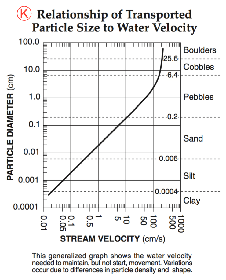
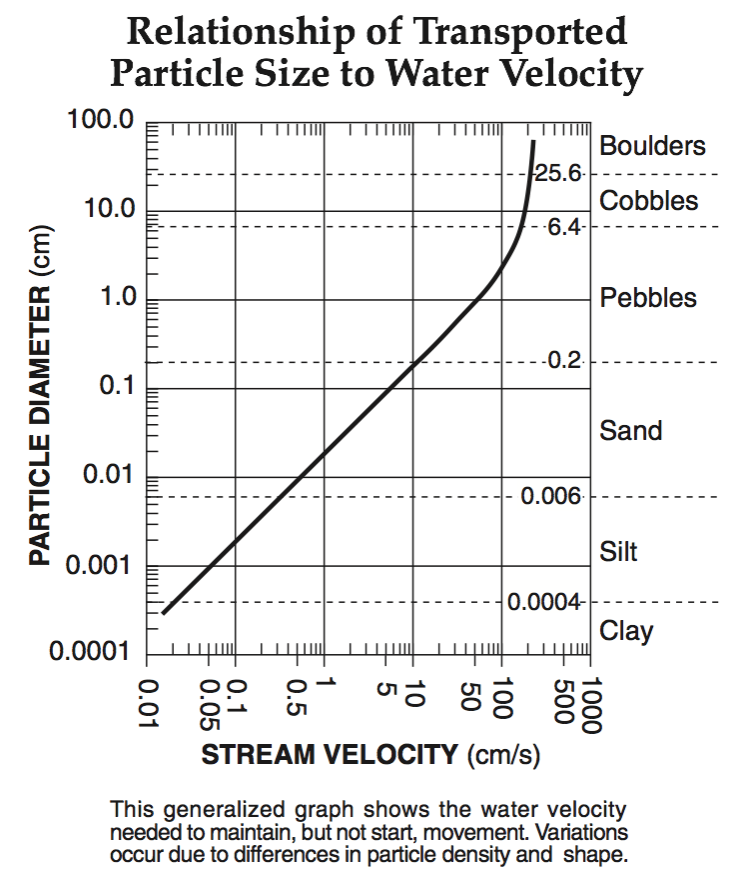
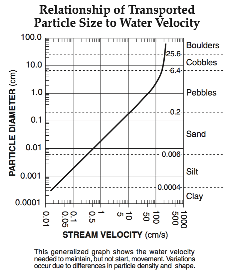
A stream’s velocity decreases from 100 cm/s to 5cm/s. Which size sediment particles will still be transported by the stream?

a)

pebbles, sand, silt and clay

b)

sand, silt and clay only

c)

silt and clay only

d)

clay only

103.

What is the minimum water velocity necessary to maintain movement of 0.1-centimeter-diameter particles in a stream?

a)

5.0 cm/s

b)

0.02 cm/s

c)

0.5 cm/s

d)

20.0 cm/s

104.

What is larger, a pebble or sand?

a)

Pebble

b)

Sand

105.

Which is smaller, sand or silt?

a)

Sand

b)

Silt

106.

Which is smaller, pebble or cobble?

a)

Pebble

b)

Cobble

107.

Which is smaller, pebble or cobble?

a)

Pebble

b)

Cobble

108.
A particle diameter of 0.07 cm corresponds to which sediment classification?
a)
sand
b)
silt 
c)
clay
d)
pebble
109.
A particle diameter of 0.7 cm corresponds to which sediment classification?
a)
sand
b)
silt 
c)
clay
d)
pebble
110.
Sediments are deposited in a river delta because the 
a)
velocity of the river decreased
b)
force of gravity decreased
c)
volume of the river increases
d)
gradient of the river increases
111.

What is the minimum water velocity necessary to maintain movement of 0.1-centimeter-diameter particles in a stream?

a)

5.0 cm/s

b)

0.02 cm/s

c)

0.5 cm/s

d)

20.0 cm/s

112.

What is the approximate minimum stream velocity needed to keep a particle in motion that has a diameter of 10 centimeters?

a)

110 cm/s

b)

190 cm/s

c)

325 cm/s

d)

425 cm/s

113.

What is the minimum rate of flow at which a stream of water can maintain the transportation of pebbles 1.0 centimeter in diameter?

a)

50 cm/s

b)

100 cm/s

c)

150 cm/s

d)

200 cm/s

114.

Which particle of quartz shows evidence of bing transported the farthest distance by the stream?

a)
b)
c)
d)
115.

Which particle of quartz shows evidence of bing transported the shortest distance by the stream?

a)
b)
c)
d)
116.

Which factor most likely caused the sediment to be sorted in the pattern shown?

a)

velocity of the river water

b)

hardness of the surface bedrock

c)

mineral composition of the sediment

d)

temperature of the water

117.

A particle diameter of 100.0 cm corresponds to which sediment classification?

a)

sand

b)

boulder

c)

cobble

d)

pebble

118.

A particle diameter of 0.001 cm corresponds to which sediment classification?

a)

sand

b)

silt

c)

cobble

d)

pebble

119.

Point X is near the top of the hill, point Y is at the base of the hill, and point Z is at sea level. A stream flows from point X through point Y to point Z. Which cross section best shows the pattern of sediments deposited by the stream as it enters the ocean near point Z?

a)
b)
c)
d)
120.

Which size particle will remain suspended longest as a river enters the ocean?

a)

Pebble

b)

Sand

c)

Silt

d)

Clay

121.
What caused the edges of these rocks to become smooth?
a)
rocks bumping and scraping against each other in a river
b)
ice scraping from a glacier
c)
sand blowing in the wind
d)
plants growing roots
122.

Four quartz samples of equal size and shape were placed in a stream. Which of the four quartz samples below has most likely been transported farthest in the stream?

a)
b)
c)
d)
123.

Which profile best shows the general depositional pattern that occurs when water from a stream enters the ocean?

a)
b)
c)
d)
124.
When a stream or river starts to slow down, it:
a)
Picks up more sediment
b)
Erodes more rapidly
c)
Deposits fine sediments, but continues carrying larger rocks
d)
Deposits larger rocks, but continues carrying finer sediment
125.
Which of the following statements is not true?
a)
Water causes more erosion on slopes without plants
b)
Water flows from higher to lower ground
c)
Faster water erodes more sediment
d)
As water slows, smaller particles are deposited first
126.

The gradual movement or removal of sediment from a location by water is called...

a)

erosion

b)

runoff

c)

slope

d)

tributary

127.

What is a floodplain?

a)

The area near a river that floods when water levels get to be too high.

b)

The area near a river that looks boring or dull.

c)

The process of water levels going over a river or stream bank.

d)

Water gathering on the surface of the Earth because it doesn't seep into the ground.

128.
The steeper the slope, the ________ the stream.
a)
Slower
b)
Broader
c)
Faster
d)
Curvier
129.

Which of these are traits of a stream’s floodplain? Select all that apply

a)

It is nutrient poor

b)

Is broader and deeper than its channel

c)

Is where the stream deposits much of its sediment load

d)

its elevation is usually higher than the river bed
130.
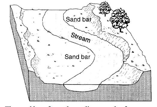
The diagram below shows a portion of a stream. The sand bar formed as a direct result of 
a)
erosion due to a decrease in stream velocity 
b)
erosion due to an increase in stream velocity
c)
deposition due to a decrease in stream velocity
d)
deposition due to an increase in stream velocity 
131.
Sediments are deposited in a river delta because the 
a)
velocity of the river decreased
b)
force of gravity decreased
c)
volume of the river increases
d)
gradient of the river increases
132.
The diagram below shows a portion of a stream. The sand bar formed as a direct result of 
a)
erosion due to a decrease in stream velocity 
b)
erosion due to an increase in stream velocity
c)
deposition due to a decrease in stream velocity
d)
deposition due to an increase in stream velocity 
133.
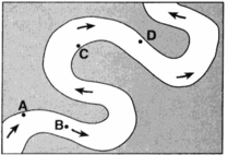
At which location is the greatest amount of sediment most likely being deposited?
a)
A
b)
B
c)
C
d)
D
134.
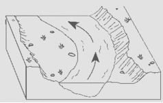
The diagram below shows a section of a meander in a stream. The arrow shows the direction of stream flow. The stream bank on the outside of this meander is steeper than than the stream bank on the inside of this meander because the water on the outside of the meander is moving
a)
Slower, causing deposition
b)
Faster, causing deposition
c)
Slower, causing erosion
d)
Faster, causing erosion
135.
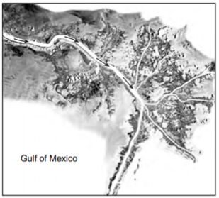
 The satellite photograph below shows the Mississippi River entering into the Gulf of Mexico. Arrows show the direction of river flow. This depositional feature in the Gulf of Mexico is best identified as 
a)
a delta 
b)
a sandbar 
c)
a barrier island 
d)
an outwash plain 
136.
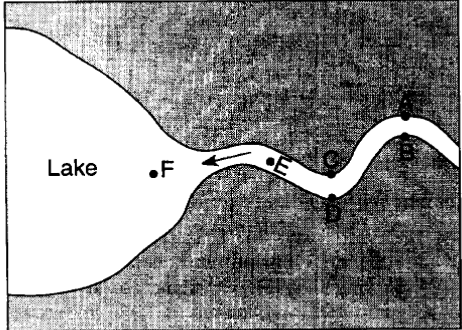
The map below represents a river as it enters a lake. 
At which locations is the amount of deposition greater than the amount of erosion?
a)
A,C and E
b)
B, D and F
c)
B, C, and F
d)
A, D and E
137.
Trees growing on the edge of a river's meander are most likely to fall into the river due to 
a)
deposition on the inside of the meander
b)
deposition on the outside of the meander
c)
erosion on the inside of the meander
d)
erosion on the outside of the meander
138.
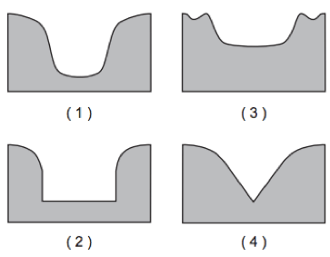
Which cross section best represents the valley shape where a rapidly flowing stream is cutting into the bedrock in a mountainous area? 
a)
1
b)
2
c)
3
d)
4
139.
Forms when a flowing river erodes an area between two mountains. 
a)
U-Shaped Valley
b)
V-Shaped Valley
c)
Kettle
d)
Moraine
140.
A meandering stream deposits most of its sediments on the
a)
inside of meanders where the stream flows faster
b)
inside of meanders where the stream flows slower
c)
outside of meanders where the stream flows faster
d)
outside of meanders where the stream flows slower
141.
What is the approximate minimum stream velocity needed to keep a particle in motion that has a diameter of 10 centimeters?
a)
110 cm/s
b)
190 cm/s
c)
325 cm/s
d)
425 cm/s
142.
Which is larger, a boulder or cobble?
a)
Boulder
b)
Cobble
143.
What is larger, a pebble or sand?
a)
Pebble
b)
Sand
144.
Which is smaller, sand or silt?
a)
Sand
b)
Silt
145.
Which is smaller, pebble or cobble?
a)
Pebble
b)
Cobble
146.

Which soil particles have the smallest pore spaces between sediments?

a)

Clay

b)

Silt

c)

Sand

d)

Cobbles