
 Worksheets
8th Grade Map Review
Total questions: 56
Worksheet time: 31mins




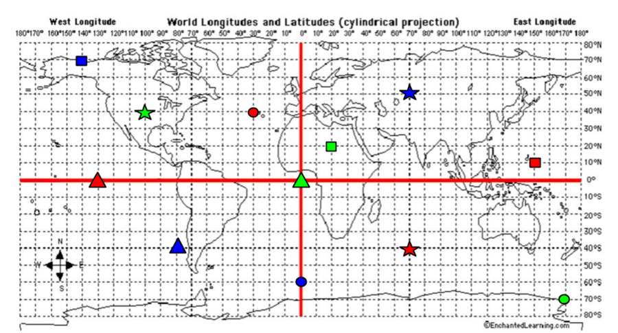
What are the coordinates for the RED star?
40*S, 70*E
40*N, 30*W
0*, 130*W
10*N, 150*E
What are the coordinates for the BLUE Star?
40*S, 80*W
60*S, 0*
70*N, 140*W
50*N, 70*E
What are the coordinates for the GREEN Star?
40*N, 100*W
70*S, 170*E
20*N, 20*E
0*, 0*

The imaginary line that divides the earth into northern and southern hemispheres.
Equator
Prime Meridian
Hemisphere

The imaginary line that divides the earth into eastern and western hemispheres.
Equator
Prime Meridian
Hemisphere
Any half of the earth
Equator
Prime Meridian
hemisphere

Lines that run east and west on a map.
lines of latitude
lines of longitude

Lines that run north to south on a map.
lines of latitude
lines of longitude

A map that shows countries, cities, or states.
topographic map
political map
road map

An illustration that explains what the symbols or colors on a map represent.
key/legend
scale

A map showing elevation (surface) using lines.
topographic map
political map
road map

A map that shows major and minor roads in cities or towns.
topographic map
political map
road map

A set of pointers that show directions on a map or globe.
key/legend
compass rose
scale

North, South, East, West are:
cardinal directions
intermediate directions

Northeast, Northwest, Southeast, Southwest are:
cardinal directions
intermediate directions

A map that shows landforms.
physical map
road map
political map

A 3D representation of the earth.
map
globe
guide

A map that shows the population (# of people) of various places.
topographic map
population map
road map

A flat representation of a location on Earth.
map
globe
guide

The relationship between an ACTUAL distance on the earth and the SAME distance shown on a map.
key/legend
scale


What is this called?
Compass Rose
Map Scale
Compass
Map Legend

The Playground is ___________ of the park.
West
South
North
East

Where is the lake?
in the mountains
under the railroad
in the forest
there is no lake
Contour Lines represent...............?
areas of equal elevation
features and important areas
used space
nothing - they are decoration
A scale drawing that measures 8 units wide and an original the measures 4 units wide has a scale factor of .....
8:1
BIG
1:2
2:1

What is the contour interval?
5 m
20 m
15 m
river

What are the darker lines called?
Waves
Roads
Index Contour
Contour Intervall

Which statement best describes the location marked by X?
It is at the top of the hill.
It is in a deep cave.
It is on the side of a mountain.
It is at the bottom of a large pit.
What is a contour interval?
The elevation change between contour lines.
The distance between two points.
The highest point on a topographic map.
A hole in the ground.

What is the contour interval of this map?
20
15
10
5
What does it tell you about a hill if the contour lines on the East side of the hill are very close together on a topographic map?
The North side of this hill has a river on it
The East side of the hill is very steep.
The West dies of the hill is very steep.
The East side of this hill is very flat.

What is located in E5
Twizzles
Ice Cream
Chips
Pizza Hut

Based on the topographic map, if a park ranger hiked West from the Radio Tower, the ranger's path would...............................
cross a canyon with a river running through it
cross another peak in the park
be flat and then go up a steep slope
go down a steep slope and them become flatter

