
 Worksheets
4th Quarter QA Review
Total questions: 63
Worksheet time: 49mins


Who is the German Scientist that came up with the theory of the Continental Drift?
Albert Einstein
Ms. Stukel
Galileo
Alfred Wegener

What is the force that moves the continents?
Conduction
Convection
Radiation
Conveyor belts

Originally the Continental drift theory was not well received by other scientist. Why?
There was a competing theory at the time that was more believable.
There was no data showing the continents ever moved.
The scientists did not know the force responsible for moving the continents.
The scientist presenting the data was unreliable.
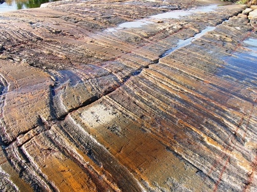

What evidence did Wegener use to support his theory?
Continents and fossils fitting together/matching-up like puzzle pieces
glacier scars and other climate evidence from temperature
mountain ranges and rocks line up across continents
all of the above

What are the two types of crust?
continental and oceanic
ocean and basin
lower and upper
thick and thin

What type of evidence was NOT used by Alfred Wegener to support his continental drift hypothesis?
evidence from landforms
evidence from fossils
evidence from human remains
evidence from climate

According to the continental drift hypothesis, the presence of similar fossils in South America and Africa supports which scientific idea?
Animals easily and frequently travel from Africa to South America.
Species of animals probably traveled between continents on natural rafts (such as trees destroyed in tsunamis).
Land bridges once existed that connected the continents.
South America and Africa were once connected together.

The continents move very slowly, only a few __________per year.
meters
kilometers
centimeters
miles

Most geologists think that the movement of Earth's tectonic plates is caused by
the rotation of the Earth.
the Earth's magnetic field.
subduction.
convection currents.


In some areas of the world, like California and Japan, earthquakes are a common occurrence. How can this best be explained?
The strong ocean currents are undermining both areas causing earthquakes.
Both areas are located near the edge of the Pacific Ocean, the unstable sand causes earthquakes.
Both areas are subjected to strong ocean wind and waves that causes earthquakes.
Both areas are on the boundary of active plates, the motion of the plates causes earthquakes.
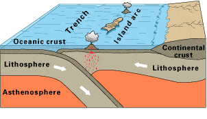
Observe this diagram of a plate boundary. One statement BEST describes what is happening. It is that
the oceanic crust is melting.
the denser ceanic crust is subducting under the less dense oceanic crust
volcanic islands are forming.
the tectonic plates are moving away from each other.


Geologists have classified rocks into three major groups of rocks which are:
inorganic, organic and chemical rocks
igneous, sedimentary and metamorphic rocks
metamorphic, chemical and non chemical rocks
sedimentary, inorganic and igneous rocks
The process by which metamorphic rock changes to igneous rock begins with
melting
erosion
deposition
crystallization
Which is responsible for buried rock becoming exposed at Earth's surface?
melting
weathering and erosion
Falling volcanic ash
cooling
A hot spot is located at the boundary of a plate
true
false
What geologic feature will occur at a hot spot ?
volcano
folded mountain
deep sea trench
crevasse
A prime example of an area over a hot spot is :
Japan
the Andes Mountains
the East African Rift
the Hawaiian Islands
Which of the following will move with time ?
a hot spot
the plate the hot spot is over
neither move
both move
Where do hotspots occur ?
Above a magma plume
Above a magma plumme
In Mr Johnsons office
In a dark alley in croydon
Earthquakes and volcanoes are most likely to happen along.....
state lines
horizons
plate boundaries

In the United States, hurricanes strike states along the __________ Ocean.
Pacific
Atlantic
Indian
Arctic

According to the graph, the most tornadoes happened in which month?
January
May
September
November

According to the data, which of these states had the most tornadoes in 2020?
Mississippi
Florida
North Carolina
Kansas
What is the name of a massive wave that is caused by an earthquake under the ocean?
tornado
tsunami
hurricane
rip tide
Which of these can NOT be predicted at least 1 day ahead of time?
Large Regional Flood
Hurricane
Earthquake
Which of these can be predicted at least 1 day ahead of time?
Large Regional Flood
tornado
Earthquake
tsunami

This map shows tornado activity in the United States between 1950 and 1998. Based on the data provided by this map, which of the following cities would be most likely to experience a tornado with a rating of F3 or greater in the next year?
Phoenix, Arizona
Topeka, Kansas
Orlando, Florida
Columbia, South Carolina

