
 Worksheets
Reading Climate Graphs
Total questions: 48
Worksheet time: 35mins

What two pieces of data can you get from a climate graph?
humidity and precipitation
cloud cover and precipitation
temperature and precipitation
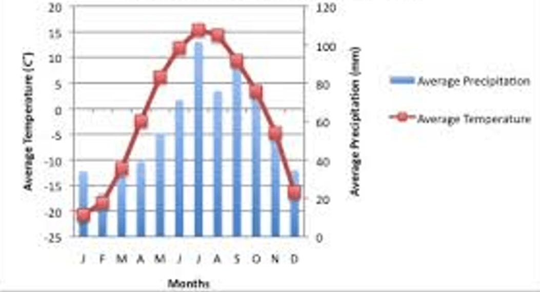

Temperature on a climate graph is shown with a ___________.
BAR
LINE

Put the first 5 months shown on the climograph in order
January
February
March
April
May
Use the climate graph to match the descriptions on top to the correct facts below.
blue bar graph
rainfall/precipitation
red line graph
temperature
July & August
months with highest precipitation
April & May
months with the highest temperature
Precipitation is water that falls to Earth. Hail, rain, sleet, and snow are four types of precipitation. Which type of precipitation is most likely to occur when the cloud and air temperatures are below freezing?
rain
hail
sleet
snow
Climate is determined by temperature and precipitation and climate is determined only by humidity, air pressure, and wind conditions.
Weather is determined by temperature and precipitation, and climate is determined only by humidity, air pressure, and wind conditions.
Climate is the condition of Earth's atmosphere at a particular time and place, and weather is the characteristic climate in an area over a long period of time.
Weather is the condition of Earth's atmosphere at a particular time and place, and climate is the characteristic weather in an area over a long period of time.

What do you notice about this climate graph?
temperature is warm year round
temperature is cold year round
dry summers
most rain in the winter

Taller bars on a climate graph show _________________.
MORE precipitation
HIGHER temperatures
LOWER temperatures

Which climate has the lowest precipitation level?
Climate A
Climate B
Climate C
none of the climates are low
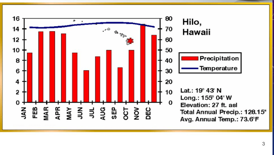
When does the least precipitation occur?
February - March
April - May
June - July
November - December

Which climate graph shows a LOWER temperature in June?
Graph A
Graph B

Which climate graph shows MORE precipitation in May?
Graph A
Graph B

Which months have the warmest temperatures?
December, January, February
March, April, May
June, July, August
September, October, November

Which climate graph shows HIGHER temperatures for the year?
Graph A
Graph B
Which graph shows a place with a very dry climate all year long?


In which month do they get the most rain in this biome?
January
May
August
November


Which biome is best represented by this climatograph?
Tundra
Desert
Tropical rainforest
Boreal Forest

Which biome is best represented by this climatograph?
Tundra
Desert
Tropical rainforest
Grasslands

How does the climate of the Taiga (chaparral) compare to that of the desert?
The chaparral has a similar temperature range, but more rainfall in the winter months than the desert
The desert has a similar temperature range, but slightly more rainfall in the winter months than the chaparral
The chaparral and desert have the same climate
The chaparral reaches below freezing and the desert doesnt

Which of the following would be an adaptation of an organism in THIS biome
really thick fur to protect against the cold temperatures
modified leaves to prevent water loss
large leaves to capture sunlight on the forest floor
dormant flower to save resources
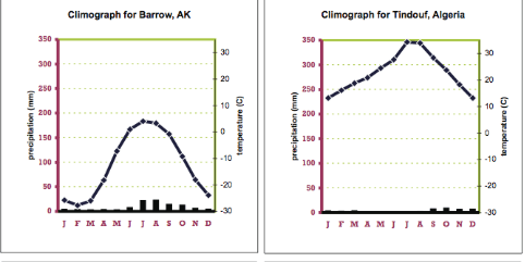
Which of the following is a similarity between the tundra and the desert?
low temperatures
high temperatures
low precipitation levels
permanently frozen ground

All of the following are true of the grassland climate graph EXCEPT?
relatively stable temperature year long
more precipitation than a desert
clearly distinct wet and dry season
the amount of precipitation is enough to support a wide variety of trees

Which biome could be represented by this climatograph?
Grassland
Temperate Forest
Boreal Forest
Temperate Rainforest

Which month has the coldest temperature?
January
April
September
March

What month has the most precipitation & highest temperature?
February
July
September
December

How can you tell this is a tundra?
Temperatures are below zero most of the year
Temperatures go up and down
There is lots of precipitation (snow)
There is a wet season and dry season
How can you tell this is a grassland?
There are 4 Seasons
There is rain all year
It is dry all year
There is a wet and dry season
How can you tell this is a temperate deciduous forest?
There is lots of rain all year
The temperature is warm all year
There are 4 seasons
There is a wet and dry season

Madrid, Spain is located in the northern hemisphere. Which description of Madrid's climate is correct?
Madrid has a cold and snowy winter.
Summers in Madrid are hot and dry.
Madrid's driest month is January.
Madrid receives the greatest amount of precipitation in July.

Use the climate graph above to answer the following question.
Calama, Chile is located in South America. What can you infer based on the climate graph above?
Calama, Chile is a grassland.
Calama, Chile is a good place to grow crops.
Calama, Chile is a desert.

Summer
Autumn
Winter
Spring

How many mm of rainfall can you expect in the month of April?
320 mm
110 mm
100 mm
90 mm


This is the climate diagram for Cairo. If you look carefully, then you will surely notice that the climate in that city is
Very dry
Humid
Cold
Wet

This is a climate diagram for the city of Moscow. What is the number of months in Moscow with temperatures below zero degrees Celsius?
Two
Three
Four
Five

This is a climate diagram for Alaska. If you look closely, what is your conclusion about the climate of this area?
The climate is pleasant and favorable
The climate is very cold
The climate is similar to that in Bosnia
It never snows here

Which climate graph shows the LOWEST rainfall in December?
Graph A
Graph B
Which climate graph shows a DESERT?
Graph A
Graph B

Which climograph has the most precipitation during the summer?
A
B
C
D
Which climograph has the most precipitation during the winter?
A
B
C
D

Which climograph do you think matches the place in the picture?


Which climograph do you think matches the place in the picture?
Which climograph has the largest degree difference between the average high and average low?
A
B
C
D
Which TWO climographs are closest to the equator (warmest)?
A
B
C
D

Based on the data in the graph, about how much annual precipitation does the tundra usually receive?
about 75-190 cm
100 cm or less
about 250-400 cm
more than 300 cm

Based on the data in the graph, which biomes receive more than 250 cm of annual precipitation?
Desert and Temperate Forest
Grassland and Tropical Rainforest
Savanna and Tundra
Tropical Rainforest and Temperate Rainforest

