
 Worksheets
Unit 4 Investigating Global Weather Patterns
Total questions: 100
Worksheet time: 2hrs 40mins
The force exerted by the atmosphere on Earth's surface by the weight of the air above the surface.
Atmosphere
Air Pressure
Wind
Humidity
The layer of air surrounding a planet that is held in place by Gravity.
Atmosphere
Air Pressure
Wind
Humidity
The Natural movement of air, sometimes with considerable force, from an area of high density and pressure to an area of low density and pressure.
Atmosphere
Air Pressure
Wind
Humidity
The amount of water vapor or moisture content in the air
Atmosphere
Air Pressure
Wind
Humidity
A scientific tool used to measure wind speed.
Anemometer
Convection
Radiation
Thermal Energy
Heat transfer caused by the rising of hotter, less dense fluids and the falling of cooler, denser fluids.
Anemometer
Convection
Radiation
Thermal Energy
The transfer of energy by the movement of electromagnetic waves or subatomic particles.
Anemometer
Convection
Radiation
Thermal Energy
The total kinetic (motion) energy of the tiny particles that make up matter; the faster the particles move, the warmer the matter becomes.
Anemometer
Convection
Radiation
Thermal Energy
An air mass with greater atmospheric pressure than the surrounding air masses; air moves away from the center of the high pressure, traveling in a clockwise direction in the northern hemisphere and a counterclockwise direction in the southern hemisphere
High-Pressure air Mass
Low-Pressure air mass
Hurricane
Ocean Currents
An air mass with less atmospheric pressure than the surrounding air masses; air moves toward the area of low pressure, traveling in a counterclockwise direction in the northern hemisphere and a clockwise direction in the southern hemisphere
High-Pressure air Mass
Low-Pressure air mass
Hurricane
Ocean Currents
A large tropical weather system consisting of an extremely low-pressure air mass with heavy rains and wind speeds of at least 119 km/h
High-Pressure air Mass
Low-Pressure air mass
Hurricane
Ocean Currents
Directional movements of ocean water; surface currents result from steady winds over the ocean surface; deep currents result from density variations due to temperature and salinity differences
High-Pressure air Mass
Low-Pressure air mass
Hurricane
Ocean Currents
The day-to-day state of the atmosphere
weather
coriolis effect
Hurricane
wind
The apparent deflection of moving air, as seen by an observer on Earth, as a result of Earth’s rotation
weather
coriolis effect
Hurricane
wind
A body of air extending over a large area (1,000 miles or more) that develops and retains specific characteristics of pressure, temperature, and humidity
Air Mass
Air Pressure
Atmospheric
Movement
Weather Map
The force exerted by the atmosphere on Earth’s surface by the weight of the air above the surface
Air Mass
Air Pressure
Atmospheric
Movement
Weather Map
Global air circulation patterns within the atmosphere held to Earth by gravity and warmed as heat radiates from Earth; influenced by convection of warm, less dense air (rises and spreads out) and cold, dense air (sinks)
Air Mass
Air Pressure
Atmospheric
Movement
Weather Map
An instrument that measures the amount of atmospheric pressure
Anemometer
Convection
Barometer
Thermal Energy
The border between an advancing cold air mass and a retreating warm air mass
Air Mass
Warm Front
Cold Front
Weather Map
The boundary between an advancing warm air mass and a receding cooler air mass
Air Mass
Warm Front
Cold Front
Weather Map
A map or chart that shows the weather conditions at a specific point in time over a specific region
Air Mass
Warm Front
Cold Front
Weather Map

What is the source for warming up ocean water?
the sun
water movement
wind
fish peeing in the ocean water
The center of a hurricane is called the ______.
center
brain
eye


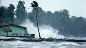

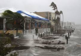
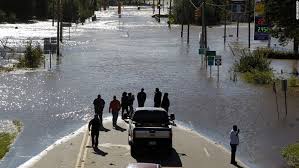


A
B
C
D

An illustration of how a convection current creates a wind, called a land breeze, is provided.Which of the following best explains what creates this convection current?
The rotation of Earth makes the air above it rotate, but not the same over land and water.
Because of its mass, Earth’s gravity creates a high pressure area over both the land and water.
Salt in the ocean makes it more dense than the land, so its gravity pulls more on the air above it.
During the evening, the land cools off more quickly than the water, so the air is different temperatures.


An illustration of how a convection current creates a wind, called a sea breeze, is provided. Which of the following best explains what creates this convection current?
Salt in the ocean makes it more dense than the land, so its gravity pulls more on the air above it.
During the day, the Sun’s energy heats up the land faster, which makes the air above it warmer.
The rotation of Earth makes the air above it rotate, but not the same over land and water.
During the day, Earth’s gravity creates a high pressure area over both the land and water.

Which of the following correctly shows the direction of convection currents in water?
A
B
C
D

The general pattern of winds around a high pressure area is clockwise, outward. The general pattern of winds around a low pressure area is counterclockwise, inward. Based on the information provided, which Texas city shown will most likely have winds from the north?
Port Arthur
Galveston
Corpus Christi
Brownsville
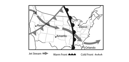
The Jet Stream is a global pattern of atmospheric movement that influences patterns in local weather. Based on the information provided in the weather map, which city shown most recently experienced a temperature rise?
Amarillo
Detroit
Orlando
Reno

The general pattern of winds around a high pressure area is clockwise, outward. The general pattern of winds around a low pressure area is counterclockwise, inward. Based on the information provided, the winds in Monterrey, Mexico will be mainly from the -
north.
east.
south.
west.

The Jet Stream is a global pattern of atmospheric movement that influences patterns in local weather. Based on the information provided in the weather map, which city shown will likely see a drop in temperature in the near future?
Albany
Bismarck
Nashville
San Diego

The Jet Stream is a global pattern of atmospheric movement that influences patterns in local weather. Based on the information provided in the weather map, which city shown most recently saw a rise in air pressure?
Baltimore
Jacksonville
Portland
Rapid City
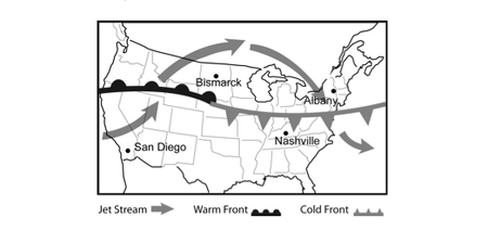
The Jet Stream is a global pattern of atmospheric movement that influences patterns in local weather. Based on the information provided in the weather map, which city shown most recently experienced a drop in temperature?
Albany
Bismarck
Nashville
San Diego

The Jet Stream is a global pattern of atmospheric movement that influences patterns in local weather. Based on the information provided in the weather map, which city shown most recently experienced a drop in pressure and can also expect a rise in pressure over the next few days?
Atlanta
Cleveland
Los Angeles
Omaha

The general pattern of winds around a high pressure area is clockwise, outward. The general pattern of winds around a low pressure area is counterclockwise, inward. Based on the information provided, which city shown will most likely have winds from the south?
Rockford
Chicago
Kankakee
La Salle

The Jet Stream is a global pattern of atmospheric movement that influences patterns in local weather. Rain and even severe thunderstorms are often associated with the passage of a cold front. Based on this information, and that provided in the weather map, which city shown is likely the one to have most recently experienced rainy conditions?
Boise
Denver
Louisville
Shreveport

The general pattern of winds around a high pressure area is clockwise, outward. The general pattern of winds around a low pressure area is counterclockwise, inward. Based on the information provided, The winds in Ann Arbor, Michigan will be mainly from the -
north.
east.
south.
west

The Jet Stream is a global pattern of atmospheric movement that influences patterns in local weather. Based on the information provided in the weather map, which city shown will most likely experience a drop in pressure over the next few days?
Baltimore
Jacksonville
Portland
Rapid City

The Jet Stream is a global pattern of atmospheric movement that influences patterns in local weather. Based on the information provided in the weather map, which city shown most recently saw a rise in temperature?
Boise
Denver
Louisville
Shreveport

The general pattern of winds around a high pressure area is clockwise, outward. The general pattern of winds around a low pressure area is counterclockwise, inward. Based on the information provided, which Texas city shown will most likely have winds from the east?
Abilene
Tyler
Houston
San Antonio
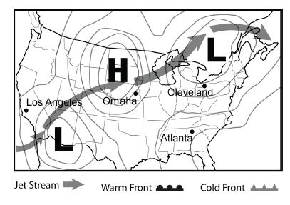
The Jet Stream is a global pattern of atmospheric movement that influences patterns in local weather. In general, one can expect clear skies with a high pressure area and cloudier conditions in areas of low pressure. Based on this information, and that provided in the weather map, which city shown most likely is currently experiencing clouds but will see clearer skies in the near future?
Atlanta
Cleveland
Omaha
Los Angeles

The general pattern of winds around a high pressure area is clockwise, outward. The general pattern of winds around a low pressure area is counterclockwise, inward. Based on the information provided, the winds in St Louis, Missouri will be mainly from the -
north.
east.
south.
west.

The Jet Stream is a global pattern of atmospheric movement that influences patterns in local weather. Rain and even severe thunderstorms are often associated with the passage of a cold front. Based on this information, and that provided in the weather map, which city shown will most likely experience precipitation in the next few days?
Albany
Bismarck
Nashville
San Diego
Where do most hurricanes develop?
Near the Equator
Middle of the United States
Near the Poles
Antarctica
The name of the system that causes the winds to spin in a hurricane
The Circular Wind Phenomenon
The Coriolis Effect
The Corleone Affect
The East-West Effect

The circulation of warm and cold matter is called...
Convection
Wind
Evaporates
Rises
Which of the following factors contributes most to formation of hurricanes?
gravitational pull of the moon and sun
toxic chemicals in the atmosphere by industry
Glaciers melting in polar regions
solar radiation heating the oceans by equator

This is the calmest part of a hurricane.
eye wall
rain bands
eye
eye and rain bands
The pressure inside of a hurricane is ______,
High
Low

Which factors would make an hurricane die? Select two.
Entering colder waters
Entering warmer waters
lack of pressure
lack of fuel (warm/humid air)
One of the major ways oceans contribute to weather systems is that the oceans -
provide a diverse habitat for many organisms.
store and transport the Sun’s heat energy.
experience changes in amounts of dissolved salt.
reach depths that can be as much as 12,000 meters.
Most of the water vapor in the atmosphere comes from evaporation of water from oceans. Most of this evaporation occurs where there is the greatest solar radiation, which is -
along the coast of Europe.
around islands in the Pacific.
near the Equator.
at both of the poles.
Which of the following correctly identifies the major source for the energy that creates hurricanes?
Sun's radiation
Ocean currents
Moon's gravity
Earth's rotation
Which of the following is a major way in which oceans contribute to weather systems?
Ocean water has high salinity.
Oceans transfer energy from the Sun.
Most volcanic activity occurs in the ocean.
Oceans have high levels of biodiversity.
Why are regions that receive more solar energy more likely to develop hurricanes?
Plants are more likely to thrive in those regions.
Those regions have more water evaporation.
Regions that receive more solar energy are typically drier.
Those regions are always located at high elevations.
Which condition is critical for the formation of a hurricane?
lower latitudes between 8 and 20 degrees of the equator
80 degrees or warmer water
low pressure
All of the above

What destroys a hurricane?
strong vertical winds
Cold water
Movement over land
All of the above
Select 2 other names for a hurricane.
typhoon
cyclone
blizzard
earthquake
Hurricanes are a very strong type of __________.
tornado
blizzard
tropical storm
tsunami

Which location has an ocean surface temperature that will make hurricanes more likely to form?
A
B
C
D

Which of the following statements are supported by the map of ocean currents?
The west coast of the United States recieves more rain because there is a cold ocean current next to it.
The west coast of the United States recieves less rain because there is a cold ocean current next to it.
The west coast of the United States recieves more tain because there is a warm current next to it.
The west coast of the United States recieves less rain because there is a warm current next to it.

