Worksheets
Natural Hazards
Total questions: 106
Worksheet time: 1hrs 17mins

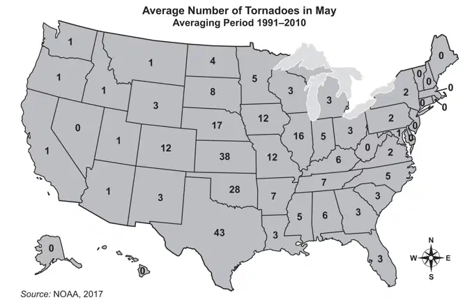
This map shows tornado activity in the United States between 1950 and 1998. Based on the data provided by this map, which of the following cities would be most likely to experience a tornado with a rating of F3 or greater in the next year?
Phoenix, Arizona
Topeka, Kansas
Orlando, Florida
Columbia, South Carolina
Which of the following is NOT a natural hazard?
Hurricane
Tornado
House Fire
Earthquake
a type of natural hazard that includes thunderstorms, tropical storms, lightning and tornadoes.
natural disaster
geology hazard
unnatural disaster
weather hazard
a type of natural hazard that includes earthquakes and volcanic eruptions
geologic hazard
weather hazard
natural disaster
volcano emergency
a fast-moving current of hot gas and volcanic matter that flows along the ground away from a volcano
aa lava
pyroclastic flow
lahar
supercell
a powerful wave caused by movement of ocean water after an earthquake, landslide or a volcanic eruption
tidal wave
tsunami
ocean wave
earthquake wave
intense, rotating thunderstorms that can develop into tornadoes
supercell thunderstorms
tornado
hurricane
volcanic eruption
is used to assign a tornado a 'rating' based on estimated wind speeds and related damage
Tornado Scale
Richter Scale
Mercalli Scale
Fugita Scale
violent type of mudflow or debris flow composed of pyroclastic material, rocky debris and water
aa lava
pyroclastic flow
lahar
supercell
A natural hazard is
an event in nature that may have a negative effect
an event in nature that does not impact human life
What is a dormant volcano?
A volcano that erupted in the past and is expected to erupt again in the future.
A volcano that has not erupted for a very long time.
A volcano that scientists think cannot erupt.
A volcano that is about to erupt very soon.
Which of the following is TRUE about earthquakes?
Earthquakes occur randomly all over the planet, so it is impossible to determine where earthquake risk is high.
Earthquakes can be accurately predicted with scientific monitoring.
Earthquakes happen along cracks in the earth's surface, called fault lines, and can only be felt near the epicenter of the quake.
Earthquakes happen along cracks in the earth's surface, called fault lines, and can be felt over large areas.
Which statement BEST explains why the earth shakes during an earthquake?
Cracks in the ground radiate outward from an earthquake’s origin.
Energy is released as waves that travel and interact with the earth.
Underground volcanic activity causes the shaking.
Water rushes in through all the cracks caused by the earthquake.

Why does having lots of plants make flooding slower?
The plants cannot absorb water very fast
The plants' roots are connected to the river
The plants absorb water (interception) so the water takes longer to reach the river
Plants increase run-off

During the year 2003, the number of earthquakes that occurred was higher than usual. The map shows the locations of some of these earthquakes.
Which question does the information on this map help answer?
How often do earthquakes happen?
When will the next earthquake happen?
Where are earthquakes likely in the future?
What will be the strength of the next earthquake?
A hurricane was predicted and people were asked to evacuate from an area. The area experienced a strong hurricane. Which description of damage is most typical for this type of natural disaster?
lightning damaged many buildings
air quality became unsafe for many people
buildings and bridges collapsed without warning
many structures were damaged by flooding and wind
Alicia wants to buy a house. She does not want to buy a house in an area where earthquakes and flooding are common. Which information would help her most in choosing where to buy a house?
a map that includes elevation of land and location of faults
a map that shows typical rainfall and location of volcanic activity
a graph of the number of earthquakes and floods in the last ten years
a graph of how much damage is caused by earthquakes compared with floods
Natural hazards can cause a variety of problems. Which type of destruction can be caused only by volcanic activity?
Choose the correct answer.
damage from flooding and wind
erosion of land along coasts and rivers
sudden crumbling of buildings and chimneys
areas being covered by ash and concrete-like mudslides
Which event can produce an earthquake?
the crash of tsunamis against a shoreline
convection of hot rock deep within the mantle
movement of tectonic plates along a boundary
the violent shaking of sections of the lithosphere

What conditions are likely for a tornado to form?
Severe thunderstorms form, air pressure suddenly drops, warm air rises quickly, & winds are blowing in the opposite direction
A low pressure system forms over warm water, moist air rises into it to give it energy, and has wind speeds of at least 74 mph
Potential energy builds up and suddenly released near fault zones, large vibrations move through rock or other Earth materials, and causes rocks to deform slowly over time
Unusually persistent dry weather due to a lack of precipitation and increased temperatures

The ring of fire is where the pacific plate meets other tectonic plates at a tectonic plate boundary. The events that are common in this area include mountain formation, volcanoes and what else?
Hurricanes
Earthquakes
Tornadoes
Landslides
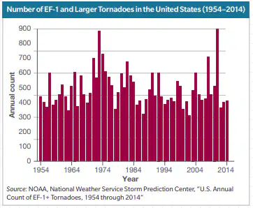
Which of the following statements is true?
The number of tornadoes per year remains about the same.
The number of tornadoes per year varies from year to year.
The number of tornadoes per year is increasing each year.
The number of tornadoes per year is decreasing each year.
Natural hazard predictions are efforts to forecast the ____, ____, and ____ of natural hazards.
occurrence
intensity
effects
precursors
All natural hazards are predictable.
true
false
Precursor events are known events that occur ____ hazards.
before
after
before or after
before and after
How are natural hazard predictions improved?
by gaining scientific understanding of hazards
collecting and analyzing data
using monitoring techniques
guessing based off of what others think
What are examples of historical data?
locations
frequencies
magnitudes
effects on environment or people
What information can be provided from past eruption data for a volcano?
eruption timing
precursor events
eruption types
eruption warnings
What are volcanoes that often have steady lava flows rather than explosive eruptions?
shield volcano
active volcano
reactive volcano
dormant volcano
What are types of technology used to monitor volcanoes?
GPS instruments
thermal imaging sensors
seismometers
tiltmeters
Which technology monitors vibrations in the ground?
GPS instruments
thermal imaging sensors
seismometers
tiltmeters
What technology monitors changes in volcanoes shape that are related to pressure changes?
seismometers
tiltmeters
GPS instruments
thermal imaging sensors
What information is used to make earthquake risk maps?
historical data
seismograph data
GPS data
thermal data
What do earthquake risk maps show?
likelihood
specific size
given area
given time frame
What are hazards that occur in locations where the atmosphere, ocean, and land interact to create specific conditions?
weather hazards
climate hazards
water hazards
atmospheric hazards
What are large-scale phenomena that are related to long-term weather patterns?
weather hazards
climate hazards
geographic hazards
atmospheric hazards
How is data collected for predicting tornadoes?
weather satellites
weather balloons
weather stations
reports from weather observers
What technology uses radio waves to identify direction and intensity of precipitation, wind direction and speed, and the locations of boundaries between large air masses?
telescopes
seismometers
tiltmeters
doppler radar
What are floods that occur suddenly as very fast moving water from excessive rainfall runs over land?
flash floods
overbank floods
coastal floods
climate floods
What are floods that happen slowly when rain or melting snow makes river or lake levels rise?
flash floods
overbank floods
coastal floods
climate floods
What are floods that happen when high winds or storms push ocean water onto shore?
flash floods
overbank floods
coastal floods
climate floods
What are asteroids that orbit close enough to Earth to pose a threat?
potentially hazardous asteroids
potentially disastrous asteroids
shooting stars
potential orbits


Engineers are designing a bridge that will better withstand earthquake forces. What is the process called when engineers use a computer to see what happens to their design during an earthquake?
variables
modeling
prediction
navigation
What is the best method for a geologist to find a scientific explanation for varying levels of damage in a city after an earthquake?
Review local newspaper reports.
Conduct a survey of residents in each area.
Create a computer model that takes into account different variables.
Analyze the strength of previous earthquakes that have struck the same area.
Scientists and engineers work together to try to reduce the damage from natural hazards. Which term is used to describe this process?
mitigation
technology
scientific method
controlling variables
A scientist is constructing a device that will predict exactly where hurricanes will travel. This device could save many lives but will be extremely expensive. Which term describes the high cost of this device?
benefit
criteria
constraint
technology
Engineers have been asked to develop a plan to reduce the effects of hurricanes on a coastal community. Which is the first step engineers should take when developing a plan to reduce the effects of a natural hazard?
identify a need
propose a solution
evaluate a solution
determine criteria and constraints

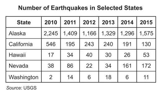
This data table shows information about earthquakes in Northern California. Which strategy is the most practical way to mitigate damage to buildings as a result of earthquakes in this area?
research methods of preventing earthquakes from happening
educate the public about how to respond in case of an earthquake
research methods of designing buildings to withstand earthquakes up to magnitude 8.0
design early detection systems to know when an earthquake larger than magnitude 5.0 will happen next
A hurricane destroyed a coastal town. Afterward, the town was rebuilt. Which term describes the rebuilding process after a natural disaster?
response
recovery
mitigation
preparation
Which statement is true of earthquake prediction?
It is unreliable.
It is impossible.
It is not important.
Scientist do not attempt it.
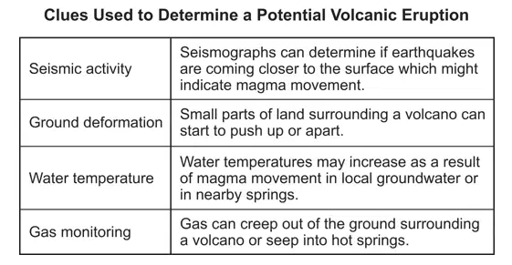
Which change does not signal a volcanic eruption?
bulging of volcano surface
a change in earthquake activity
an increase in thunderstorms near the volcano
a change in the amount and composition of volcanic gases
Which event suggests that a volcanic eruption may occur in the very near future?
a tsunami forms
a sudden weather change
an increase in earthquake activity
an increase in the amount of dust in the air
Which scientific instrument is used to help predict volcanic eruptions?
barometer
microscope
seismograph
anemometer
A scientist will use a model to predict when a volcano might erupt again. What kind of model is the scientist most likely to use?
diagram
physical model
computer model
conceptual model
Which natural hazard is caused from an underwater earthquake?
tsunami
waterspout
mass wasting
volcanic eruption
How does distance from the epicenter of an earthquake change the earthquake’s effects?
The strongest effects are usually felt near the epicenter.
The strongest effects are usually felt farthest from the epicenter.
The strongest effects are usually felt in a line extending north and south from the epicenter.
The strongest effects are usually felt in a ring surrounding the epicenter with a radius of several miles.
What causes an earthquake to happen?
Rocks deform slowly as a result of physical stress.
Rocks along a fault move suddenly and release energy.
Large amounts of rock suddenly shift downward when large holes form underground.
Energy is transferred to rock layers from convection currents in the oceans and the atmosphere.
Which event might signal a volcanic eruption?
a nitrogen odor
the erosion of vents
a change in gases emitted
the formation of heavy thunder clouds
Geologists mapped a particular area and found large limestone beds, with water flowing underground. Which natural hazard would be most likely to be predicted by the geologists from this information?
drought
tsunami
sinkhole
earthquake
Scientists are collecting data on barometric pressure. Which type of natural hazard can scientists predict with these data?
volcano
tornado
earthquake
asteroid impact
Which of these is a major cause of a mudslide?
drought
forest fire
earthquake
heavy rain
Which of these is most responsible for global deforestation?
forest fires
climate change
increased need for furniture
increased demand for agriculture

A student measured the air temperature at a particular location every three hours for one day. He made a bar graph to organize his findings. The student then compared his findings with information he obtained from a nearby weather station. He found that the weather station’s temperature measurements were three degrees warmer at each three-hour interval than the measurements he had taken. What is a likely explanation for the difference?
Weather stations do not use the most precise tools.
The student’s thermometer was calibrated incorrectly.
The student made a mistake in recording two temperature readings.
Both the student and the weather station reported incorrect temperatures.

The map shows locations where volcanic activity has been active for several decades. Which other type of natural event could scientists predict from these data?
sinkholes
landslides
forest fires
earthquakes
Which natural hazard often causes another natural hazard?
An earthquake often causes a drought.
A forest fire often causes a flood.
A hurricane often causes a flood.
An earthquake causes_________that are strongest near the center.
Vibrations
Floods

What is a hazard caused by tsunamis?
Shaking of the ground that damages buildings
Poisonous gases
Huge waves that can wash away towns
Lava Flows

What can scientists do to reduce the impact of tsunamis?
Use tiltmeters to monitor changes in the land
Measure poisonous gas levels on land
Use monitors out in the ocean to monitor wave heights and send messages to the coast
Check lava flows

What can we do to reduce the impact of volcanoes?
There is nothing that can be done
Monitor gases, temperature changes and earth movements close to the volcano.
Build earthquake proof structures
Do drop, cover and hold on drills

What can we do to reduce the impact of earthquakes?
There is nothing that can be done
monitor gases near a volcano
monitor temperatures near a volcano
Design buildings that can withstand some shaking by earthquakes