
 Worksheets
VA SOL EARTH SCIENCE 9TH GRADE
Total questions: 86
Worksheet time: 52mins

Which of the following puts the steps of a scientific experiment in the
correct order?
A 2, 1, 3, 4
B 4, 2, 3, 1
C 2, 1, 4, 3
D 2, 3, 1, 4
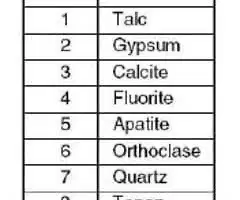
The chart shows the Mohs scale for measuring the hardness of minerals. A
mineral that can scratch fluorite and can be scratched by orthoclase is able
to
A
scratch both calcite and quartz
B: be scratched by both calcite and quartz
C: scratch calcite and be scratched by quartz
D: be scratched by calcite
Cyanite, quartz, and leucite
may be grouped together because they all
contain
F aluminum
G carbon
H potassium
J silicon
when existing rocks are buried deep and are heated by a nearby source of magma
heat and pressure
eroision
allows crystals to form
heat and pre
cooling and hardening
heat and pressure
occurs when large sediments are glued together by minerals deposited between the
sediments.
Cementation
melting
when rocks are buried deep enough to be melted back into magma
melting
cooling
are small pieces of loose materials such as rock fragments, mineral grains, and bits of plant
and animal remains.
melting
Sediments
occurs when small sediments stick together to form solid rock.
Compaction
Cementation
is the laying down of rock forming material from any natural process
Deposition
sediments
is the movement of weathered materials to new locations, where they are then deposited.
Erosion
weathering
rocks can be remelted to form magma, beginning at the beginning again
Metamorphic
sedimentary
igneous rocks
all
Being buried deep under the surface in areas of high temperatures and pressures or coming in contact with
magma can cause these sedimentary rocks to change to
metamorphic rocks
loose materials
Over time sedimentary rocks can be (a) by earthquakes or other geologic processes.
These pieces of igneous rocks are cemented together with other bits of rock and form a sedimentary rock called
conglomerate
sediments
These bits of broken rock are washed away
by rains
deposited in a river
all
The igneous rock then breaks apart over time through the
process of weathering
molten rock
Lave hardens into igneous rock
molten rock on the surface
molten rock under the surface
The magma hardens into igneous rock
molten rock under the surface
molten rock on the surface
Technically, ALL rocks start as magma.
true
false
Igneous rocks start
magma
rock
Earth undergoes regular patterns of change and natural cycles, both quickly and over time. Explain how
minerals and rocks are a result of Earth’s regular patterns of change and natural cycles.
(a)
General map features
Hills, valleys, rivers,
gentle slope, steep slope
depressions
and
rivers
all
Things topographic maps show
shows relief using contour lines. Relief is the highs
and lows of the land
sky and space
how you know where the river is
Contour lines will form a "V" and point upstream.
it will form a "g"
indicated by an "X" usually the peak of a hill or mountain
spot shot
indes contour
marked point of exact elevation of a specific point
spot shot
benchmark
lines that indicate a depression
hachure line
contour
line
contour line that is thicker and labled with
the elevation
benchmark
spot shot
index contoure
connect lines of equal elevation.
contour line
index contour
hachure line
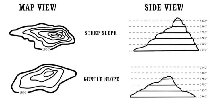
Topographic Profiles:
side view
profile
vertical
contour profile
Major uses of GPS
Travel
Military
hiking
all
GPS allows you to find
Latitude/Longitude
Elevation
Speed of travel
Direction o
Elevation
ALL
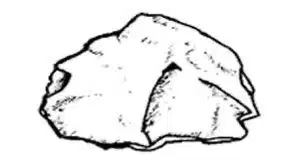
A student found the rock shown here and weighed it to determine its mass. What steps should the student take to find its density?
A Determine its volume by how much water it displaces, then divide mass by volume.
B Determine its volume by multiplying length x width x height, the divide mass by volume.
C Crush the rock to a powder and measure its volume in a graduated cylinder, then divide mass by volume.
D Determine its volume using the formula for the volume of a sphere (V = 4/3πr3), then divide mass by volume.
A student set up an experiment to test the effects of soil compaction on plant growth. The student
put equal weights of moist soil into 10 containers, planted a bean seed one inch deep in each
container, and then firmly compacted the soil in 5 of the containers. After the seeds sprouted, the
student measured the height of each plant every day and kept a record of the results. What else must
the student do over time to ensure a valid experiment?
F Water any container in which the soil feels dry
G Water all of the containers the same amount and at the same time
H Water any of the plants that seem to be growing more slowly than the others
J Water the plants in compacted soil more
than those in uncompacted soil

One step in determining the metal content of a ring is to find the
volume of the ring. What is the volume of this ring?
A 1.7 mL
B 3.0 mL
C 4.7 mL
D 7.1 mL
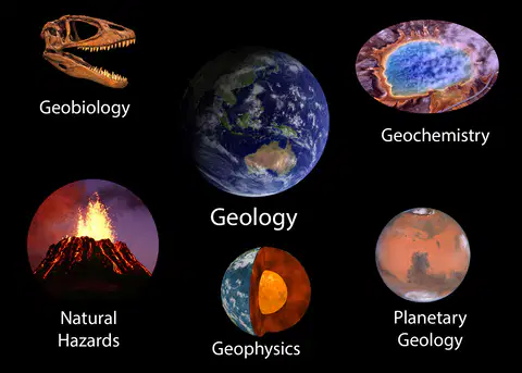
Geology – the study of
earth's physical structure, history
and processes.
the oceans's floor and ocean processes

Oceanography – the study of
ocean floor and ocean's processes
the stars, planets, and galaxies
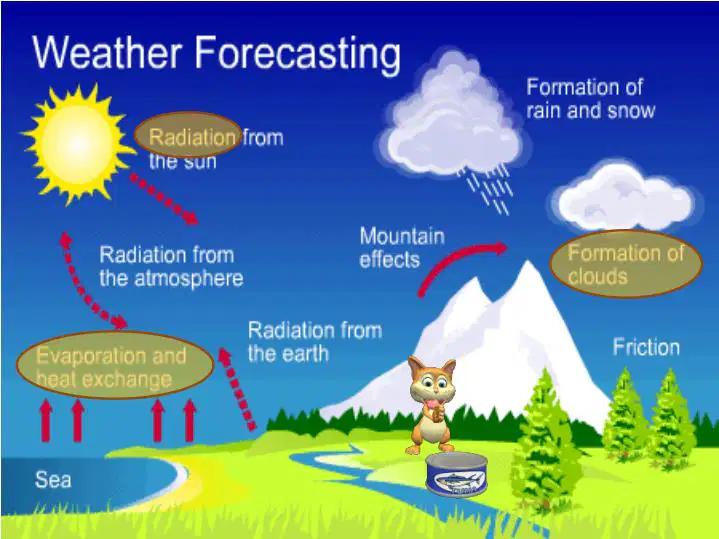
Meteorology – the study of
earth's physical structure, history, and process
the atmosphere, climate and weather

Astronomy – the study of
the stars, planets, and galaxies
study of humans

hypothesis
educated guess
the standard by which the results are measured
Independent variable
the variable being measured
the variable being tested and can be changed
Dependent Variable
the variable being measured.
the variable that cannot be changed.
Constant
the variable that cannot be changed.
educated guess
Control
Statement that indicated if hypothesis is correct or not
the standard by which by which the results are measured
conclusion
educated guess
Statement that indicated if hypothesis is correct or not
Density: Calculate the density of the
following mineral samples and plot
the data on the graph.
Sample #1: mass=90g, volume=30mL
Sample #2: mass=75g, volume=25mL
Sample #3: mass=60g, volume=20mL
#1, #2, #3
all
3mL
0
SI for distance/length:
meter (m)
liters (L)
SI for mass:
meters (m)
gram (g)
SI for volume:
kelvin (k)
liters (L) or cubic m (m3)
SI for density of regular solids:
g/cm
3
g/ml
SI for density of IRREGULAR solids:
g/cm
3
g/ml
SI for temperature:
cubic
kelvin (k)
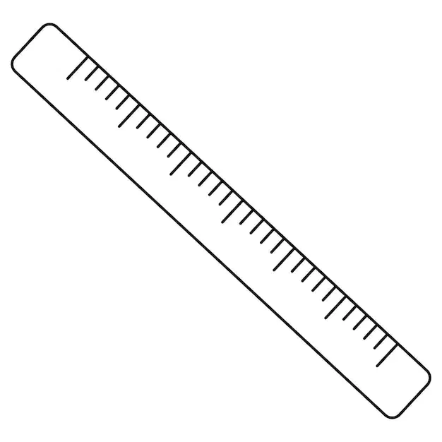
How is the tool use to measure?
meters
length
mass
grams

How is the tool use to measure?
length
meters
liters (L)
volume

How is the tool use to measure?
grams (G)
mass
volume
length
shows the locations of primary and secondary roadways, cities, places of interest
star chart
road maps
weather map
shows the elevation of a specific location
Topographic map
Geologic map
shows the underlying geologic formations, fault lines, etc. of an area
Geologic map
Bathymetric map
shows the depths of the ocean floor or large bodies of water
Bathymetric map
globe
a map showing the location of constellations, planets, and deep sky objects in the sky
physical relief map
globe
star chart
a map showing current or forecast weather conditions for an area
Weather Map
road map
a map that uses color and shading to indicate differences in elevation
globe
physical relief map
a map of the world on a sphere (the most accurate projection)
globe
bathmetric map
lines show distance in degrees North and South of the equator.
latitude
longitude
lines are referred to as parallels.
longitude
latitude
The Northern Hemisphere runs
from
0 degrees
to the North Pole
0 degrees
to the South Pole
The Southern Hemisphere runs from
0 degrees to the North Pole
0 degrees to the South Pole
Equator
0 degrees
90 degrees N
90 degrees S
North Pole
90 degrees N
0 degrees
90 degrees S
South Pole
90 degrees S
90 degrees N
0 degrees
lines show distance in degrees East and West of the Prime Meridian.
Longitude
Latitude
lines are referred to as meridians
longitude
latitude
0 degree longitude (runs through
Greenwich, England)
(a)
is 180 degree longitude (halfway around the Earth from the Prime Meridian,
halfway between China and California in the middle of the Pacific Ocean).
(a)
Meridians are closer together
at the poles
at the equator
Meridians are further apart
at the poles
at the equator
how many standard times zones are there?
12
24
How many time zones are in the Unites States of America
4
pacific, Mountain, Central, and Eastern
2
Things you find on a map to help you identify features:
compass rose, legend, map scale
shoes
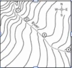
The river shown on the topographic map flows fastest at point
F 1
G 2
H 3
J 4
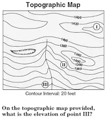
On the topographic map provided, what is the elevation of point
III?
A 1260 feet
B 1280 feet
C 1300 feet
D 1360 feet
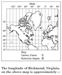
The longitude of Richmond, Virginia, on the map to the right is
approximately
F 75 degrees W
G 38 degrees N
H 38 degrees W
J 75 degrees N
what does the acronym GPS mean
Good people smiling
Global Positioning System
components of a gps
satellites
radio systems
base signals
dancing thinking
laughing

Topographic Profiles:
vertical view
contour map
side view
profile

