wayground logo

Free Printable Worksheets

Font size

S
M
L
XL
Worksheets

Weather and Climate Test Review

Total questions: 58

Worksheet time: 30mins

Name
Class
Date
1.

What causes this?

a)

Static Electricity

b)

Electric Current

c)

Charged Nitrogen atoms

d)

Excess solar energy in the storm
2.
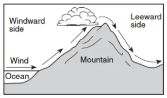
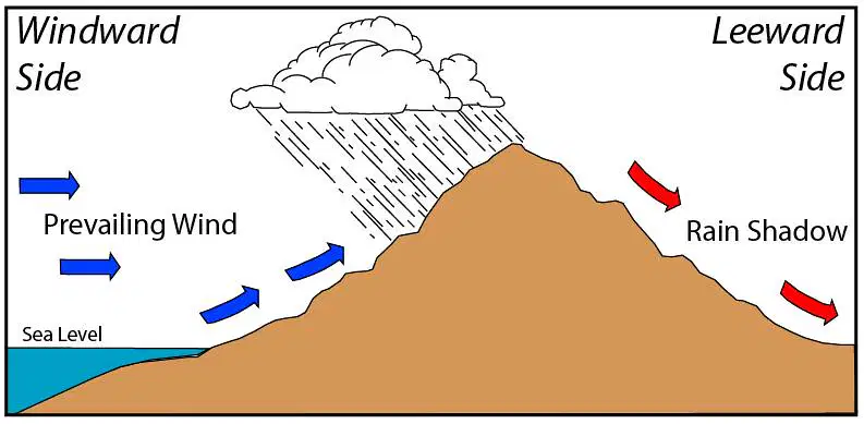
The diagram below shows how prevailing winds cause different weather conditions on the windward and leeward sides of a mountain range. Clouds usually for on the windward sides of mountains because this is where the air...
a)
rises and cools.
b)
rises and warms.
c)
sinks and cools.
d)
sinks and warms.
3.
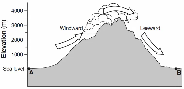
The arrows on the cross section below show the prevailing wind that flows over a mountain. Points A and B represent location on opposite sides of the mountain. Which statement correctly describes the differences in the climate of locations A and B?
a)
Location A is warmer and drier than location B.
b)
Location A is cooler and wetter than location B.
c)
Location B is warmer and wetter than location A.
d)
Location C is cooler and drier than location A.
4.
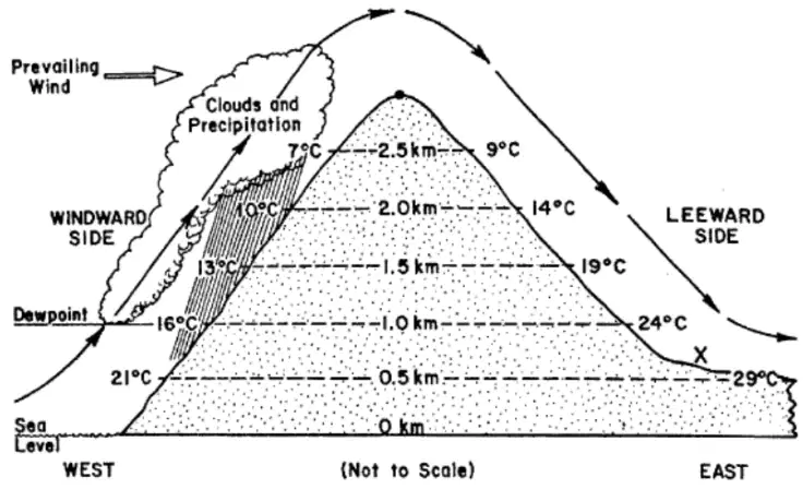
Which feature is probably located at the base of the mountain on the leeward side (location X)?
a)
A desert
b)
A jungle
c)
A forest
d)
A large lake
5.
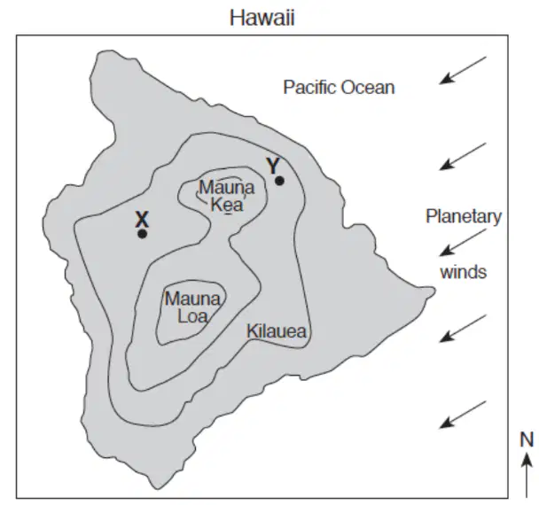
The map below shows the locations of 3 volcanoes on the island of Hawaii. The arrows represent the direction of the global winds. Points X and Y represent surface locations on the island. Which answer below explains why location X usually receives less annual precipitation than location Y.
a)
Location X is on the leeward side of the volcanoes and receives more precipitation.
b)
The volcano stops the planetary winds from reaching the other side of the mountain.
c)
Location X is on the leeward side of the volcanoes and receives less precipitation.
d)
The heat from the volcano dries the air and decreases precipitation.
6.
The diagram below shows the windward and leeward sides of a mountain range. Arrows show the movement of air over a mountain. Points A and B represent locations at sea level on Earth's surface. Explain why air cools as it rises up the mountain.
a)
The air molecules are closer together.
b)
The air molecules collide more.
c)
The air molecules condense.
d)
The air molecules are spread apart.
7.
The heat from the sun _______ the water in the ocean leaving only salt behind.
a)
Condenses
b)
Evaporates
c)
Precipitates
d)
Circulates
8.
_______ is how warm or wet a place is.
a)
Humidity
b)
Climate
c)
Temperature
d)
Precipitation
9.
______ have a big effect on climate because they are big and they push air up where it can cool causing it to snow or rain.
a)
Buildings
b)
Trees
c)
Mountains
d)
Ramps
10.
Large bodies of water help to ___________ the temperature of coastal areas.
a)
Warm
b)
Cool
c)
Moderate
d)
Dry out
11.
_______________ is one of the five factors that affect climate. This is because the further you get from the equator, the less direct solar energy you receive.
a)
Elevation
b)
Latitude
c)
Longitude
d)
Ocean currents
12.
Which of the following statements is true?
a)
As elevation increases the average temperature increases.
b)
As latitude increases the average temperature increases.
c)
As latitude decreases the average annual temperature increases.
d)
As elevation decreases the average annual temperature decreases
13.
Which two things determine climate?
a)
Air pressure
b)
Precipitation
c)
Dew point
d)
Temperature
14.
The leeward side of the mountain can also be called the ___________ side of the mountain. As air sinks temperatures rise causing _________, creating the rain shadow.
a)
dry, evaporation
b)
wet, evaporation
c)
dry, precipitation
d)
wet, precipitation
15.
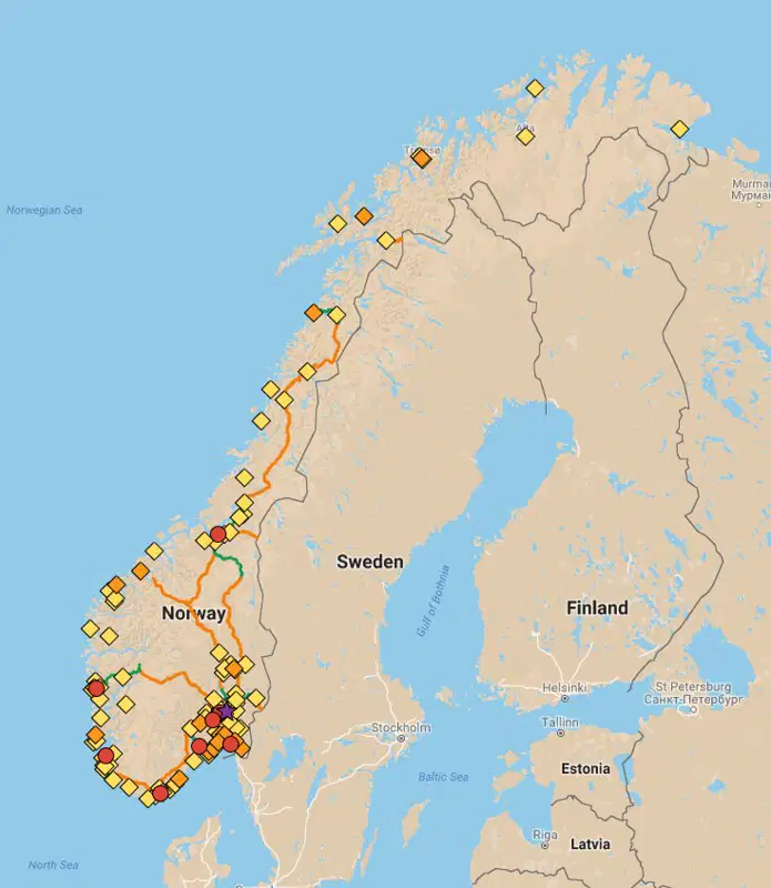
Norway and Greenland are at similar latitudes. Which evidence best defends the claim that Norway has a warmer climate than Greenland.
a)
The sun shines brighter in the as you approach the prime meridian.
b)
Warm ocean currents pass by Norway, while Greenland has cold ocean currents.
c)
Norway has more mountains, which warm things since it takes the area closer to the sun.
d)
The global winds that hit Norway are different from those that hit Greenland.
16.
Why does the equator experience about the same temperatures year round?
a)
It tilts away from the sun and gets much less direct solar energy.
b)
It has no prevailing winds.
c)
It has no mountains to affect its climate.
d)
The sun’s rays strike the equator at a direct angle all year.
17.
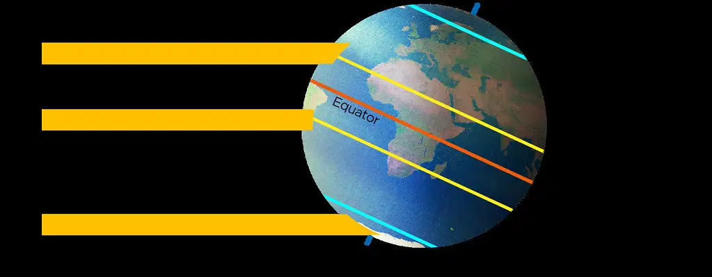
What season would this be in the southern hemisphere?
a)
Summer because it's getting less direct solar energy.
b)
Summer because it's farther from the sun.
c)
Summer because it's getting more direct solar energy.
d)
Winter because it's getting less direct solar energy.
18.
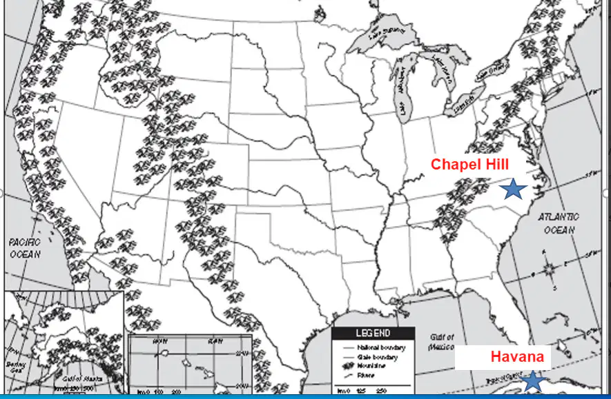
Which factor affects both of the cities starred below based on what you can tell from the map?
a)
Elevation
b)
Latitude
c)
Altitude
d)
Ocean Currents
19.
Which sentence best describes how latitude and temperature are related?
a)
Lower latitude= colder air temperature
b)
Higher latitude= colder air temperature
c)
Higher latitude = warmer temperatures
d)
There is no direct correlation between latitude and temperature
20.
Warm ocean currents generally come from the
a)
north pole
b)
south pole
c)
equator
d)
North and south pole
21.
Climates are made because energy from the sun makes water end up in the ________
a)
Atmosphere
b)
Rivers
c)
Lakes
d)
Ocean
22.
_______ is how warm or wet a place is.
a)
Humidity
b)
Climate
c)
Temperature
d)
Precipitation
23.
_______ are home to more than half of the plant and animal species in the world.
a)
Deserts
b)
Rainforests
c)
Tundras
d)
Option 4
24.
One way to study climate change is by counting
a)
Icebergs
b)
Snowfall
c)
The plants
d)
Tree rings
25.
Rainforests are great for _______ because they are warm and wet.
a)
Animals
b)
Growing
c)
Cactus
d)
Penguins
26.
Carbon Dioxide (CO2) is a gas that holds in ______.
a)
Heat
b)
Cold
c)
Water
d)
Dust
27.
If it is a cold and wet climate you might be in a ________ forest.
a)
Temperate
b)
Rain
c)
Coniferous
d)
Deciduous
28.
The north and south poles are bitterly cold ________>
a)
Rain forests
b)
Tundras
c)
Deserts
d)
Praries
29.
Higher winds over a long period of time would be a change in climate.
a)
True
b)
False
30.
A change in temperature and or precipitation for a day would be a change in climate.
a)
True
b)
False
31.
A change in temperature and or precipitation for a year would be a change in climate.
a)
True
b)
False
32.
A change in temperature and or precipitation for 30 years would be a change in climate.
a)
True
b)
False
33.
Storms are caused by the ____ of the sun, water in the air, and the spin of the Earth.
a)
light
b)
vapor
c)
heat
d)
gas
34.
Storms are ______ weather.
a)
normal
b)
extreme
c)
average
d)
regular
35.
What is the mysterious weather that occurs from time to time over the Eastern Pacific?
a)
El Nino
b)
Hurricanes
c)
Storms
d)
Tornadoes
36.
_______ and ______ are storms that can be the size of Texas.
a)
Hurricanes and tornadoes
b)
Tornadoes and Typhoons
c)
El Nino and Tornadoes
d)
Hurricanes and Typhoons
37.
The hollow spot in the middle of a hurricane and typhoon is called the eye and happens because
a)
of their slow rate of spin
b)
of their high rate of spin
c)
the earth is spinning
d)
the earth is flat.
38.
The easiest way for electrons to spread away from each other is to find a path to the ______.
a)
Sky
b)
Clouds
c)
Trees
d)
Ground
39.
Thunder is made when lightening heats air to 5x the temperature of the _____.
a)
core
b)
sun
c)
moon
d)
air
40.

What exists in cities that can cause the heat island effect?

a)

Rooftops

b)

Blacktop parking lots

c)

Blacktop roads/pavement

d)

Parks

41.

An urban area warmer than the surrounding areas

a)

Grassland

b)

Urban sprawl

c)

Heat Island

d)

Macroclimate

42.

How could having more ice coverage lead to cooler temperatures?

a)

Snow and Ice reflect less solar energy

b)

Snow and Ice reflect more solar energy

c)

Blue and Green absorb less energy then snow

d)

There is no relation between ice coverage and temperatures

43.

Why should you wear light colors on a hot day?

a)

Lighter colors have a higher albedo rate and reflect more solar energy

b)

Darker colors have a higher albedo rate and reflect more solar energy.

c)

Lighter colors have a lower albedo rate and absorb more solar energy.

d)

There is no tie between color and energy absorption or reflection.
44.

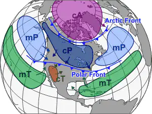
Due to the air mass shown on this map, the weather in Michigan would be described as

a)

Cold and wet

b)

Hot and dry

c)

Cold and dry

d)

Hot and wet

45.

Due to the air mass shown on this map, the weather in Arizona would be described as

a)

Cold and wet

b)

Hot and dry

c)

Cold and dry

d)

Hot and wet

46.

Due to the air mass shown on this map, the weather in Seattle, WA would be described as

a)

Cold and wet

b)

Hot and dry

c)

Cold and dry

d)

Hot and wet

47.

Due to the air mass shown on this map, the weather in Miami, FL would be described as

a)

Cold and wet

b)

Hot and dry

c)

Cold and dry

d)

Hot and wet

48.

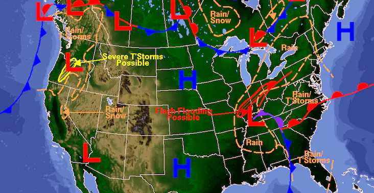
Due to the high pressure system over Michigan the weather would be

a)

Cloudy

b)

Sunny

c)

Rainy

d)

Cold

49.

As you look at this map, if you were predicting weather for Texas, which best fits?

a)

Cold and cloudy

b)

Warm and sunny

c)

cold and sunny

d)

Warm and cloudy

50.

Based on what you see on this map, what would you predict for Florida weather tomorrow?

a)

Warm and hot

b)

Cold and cloudy

c)

Warm and cloudy

d)

Cold and Sunny

51.

Based on what you see on this map, what would you predict for Michigan weather tomorrow?

a)

Warm and hot

b)

Cold and cloudy

c)

Warm and cloudy

d)

Cold and Sunny

52.

Refers to the the present state of the atmosphere

a)

Dew Point

b)

Weather

c)

Humidity

d)

Climate

53.

The amount of water vapor in the air is described in terms of

a)

Cloud coverage

b)

Air Pressure

c)

Wind Speed

d)

Relative Humidity

54.

Anemometers like this catch air in order to calculate

a)

Temperature

b)

Air Pressure

c)

Wind Speed

d)

Humidity

55.

This device is used to measure

a)

Wind Speed

b)

Air Pressure

c)

Temperature

d)

Relative Humidity

56.

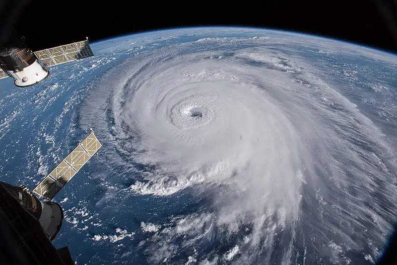
The image shows a

a)

Thunderstorm

b)

Blizzard

c)

Tornado

d)

Hurricane

57.

What would be the best prediction for the weather in Kentucky, Southern Illinois and Southern Indiana? (remember that air moves from High to Low pressure) (check all that apply)

a)

Sunny

b)

Clear

c)

Windy

d)

Cloudy

58.
What are the two main factors that determine the climate of an area?
a)
precipitation and humidity
b)
temperature and air pressure
c)
wind conditions and humidity
d)
temperature and precipitation