
 Worksheets
OCE Module 1 Review
Total questions: 75
Worksheet time: 3600secs
What type of Plate Boundary has the most explosive earthquakes, volcanoes, and tsunamis?
Transform Boundary
Convergent Boundary
Divergent Boundary
Pacific Ring of Fire
What plate boundary type is where we find subduction zones?
Transform
Convergent
Divergent
Pacific

What is a subduction zone?
a deep sea trench
near seafloor spreading
where two divergent plates seperate
when two convergent plates collide and one goes under the other
A continental and oceanic plates are colliding at a convergent boundary, which plate is subducted (goes under the other).
Neither they collide and form mountains
the continental plate will be subducted
the oceanic plate will be subducted
they will both be subducted.

At what plate boundaries will we find volcanoes?
Transform
Convergent
Divergent
Convergent and divergent
What is a divergent plate boundary?
where two plates are pulling apart
where two plates are coming together
where two plates are moving past one another
a type of fine china
What is a convergent plate boundary?
where two plates are pulling apart
where two plates are coming together
where two plates are moving past one another
a type of fine china
What is a transform plate boundary?
where two plates are pulling apart
where two plates are coming together
where two plates are moving past one another
a type of fine china
When a continental and continental plate have a convergent plate boundary what happens?
the older plate subducts under the younger one
the younger plate subducts under the older one
both plates collide and go upward forming mountains
both plates become subducted forming a rift valley

In continental-oceanic convergent boundaries how are volcanoes created and fed?
Oceanic-continental convergent do not form volcanoes
the inner core has channels to the volcanoes
the subducted plate melts and then the magma comes back to surface.
the sun melts the rock inside the mountain making it a volcano
A fault is a......
Break in the earths crust at a plate boundary
a rift valley at a divergent fault
the volcano formed by a divergent boundary
break at a convergent fault boundary
which faults have earthquakes?
Convergent
Transform
Divergent
All faults have Earthquakes
A continental-continental convergent boundary creates what?
Earthquakes, Deep Sea Trenches, volcanoes
Mountains and Earthquakes
Rift valleys, volcanoes, and mountains
Mid-ocean ridges, and volcanoes
The majority of the volcanoes on earth are found where?
In japan
The United States
China
The Pacific Ring of Fire
The deepest known point on earth is where?
In a Vietnamese Super cave, Hang Son Doong
Challenger Deep, the deepest known point in the Mariana Trench
The bottom of Death Valley in Nevada
The bottom of the grand canyon
What plate boundary creates new oceanic crust?
convergent
divergent
transform
continental
What is the super continent theorized by Alfred Wegener called?
Pandora
Pantera
Pangea
Paragon
the lithosphere is composed of.....
the crust and the upper mantle
the asthenosphere and the crust
the crust and the core
the outer core and inner core.
A normal fault is caused by what type of force?
Compression
Shear
Tension
Peer Pressure
What features will be found at a convergent continental-continental plate boundary
Rift valley
Deep Sea Trench, tsunamis and earthquakes
Mountains and earthquakes
Volcanic Island arc
What features will be found at a convergent continental-oceanic plate boundary
Rift valley
Deep Sea Trench, tsunamis and earthquakes
Mountains and earthquakes
Volcanic Island arc
What features will be found at a convergent oceanic-oceanic plate boundary
Rift valley
Deep Sea Trench, tsunamis and earthquakes
Mountains and earthquakes
Volcanic Island arc
What features will be found at a divergent oceanic-oceanic plate boundary
Rift valley
Deep Sea Trench, tsunamis and earthquakes
Mountains and earthquakes
Mid Ocean ridge
What features will be found at a divergent continental-continental plate boundary
Rift valley
Deep Sea Trench, tsunamis and earthquakes
Mountains and earthquakes
Mid Ocean ridge
A puzzle like fit of the continents is evidence for (a) .
Paleomagnetism is evidence for (a) .
The locations of volcanoes and earthquakes is evidence for (a) .
Matching fossils on different continents is evidence for (a) .
The age of the seafloor as it moves from spreading centers is evidence for (a) .
Matching rock structures and ancient climates are evidence for (a) .
The thickness of sediment on the ocean floor is evidence for (a) .
The presence and age of island chains is evidence for (a) .
Continental drift is a (a) and Plate Tectonics is a (b) .
The process that causes magma to rise and fall, moving the lithospheric plates is
fusion
convection
radiation
conduction
Seafloor spreading
creates new ocean crust.
creates new continental crust.
destroys ocean crust.
destroys continental crust.
Seafloor spreading occurs at
close to the shorelines.
the mid-ocean ridge.
the deepest ocean trench.
Match the following
Lithogenous
Derived from the breakdown of rocks
Biogenous
Derived from the remains of living organisms
Cosmogenous
Derived from outer space
Hydrogenous
Derived from water chemistry
Land is taller than the ocean is deep.
True
False
Moving crustal plates plunging back into Earth's mantle causes this feature
deep-ocean trench
turbidity currents
continental rise
submarine canyon
What is the downslope movements of dense, sediment-laden water
turbidity currents
shelf currents
mid-ocean ridges
atolls


Sediments made from microscopic shells that settle to the bottom when the organisms that produced them die are called
biogenous sediments.
hydrogenous sediments.
manganese nodules.
terrigenous sediments.
Which means the same as lithogenous?
biogenous
authigenous
terrigenous
cosmogenous
Which of the following is an exotic sediment type found in least abundance in the oceans?
cosmogenous sediments
lithogenous sediments
hydrogenous sediments
biogenous sediments
Which of the following are hydrogenous sediments?
evaporites
tektites
quartz
oil

Radiolarians and diatoms (both microorganisms with silicon based shells) are both examples of
sources of siliceous oozes
near large animals
sources of calcerous oozes
only found on land
Foraminifera (calcium based) shells are likely to be deposited and form
calcerous ooze
silaceous ooze
heavy metal deposits
uranium deposits
Oceans cover about ______ of the surface of the earth.
60%
70%
80%
90%
The following are the oceans according to size
Pacific, Atlantic, Indian, Arctic, Antarctic
Pacific, Indian, Atlantic, Arctic, Antarctic
Atlantic, Pacific, Indian, Antarctic, Arctic
Pacific, Atlantic, Indian, Antarctic, Arctic
The _________ is located in the North Pole.
Antarctic Ocean
Southern Ocean
Arctic Ocean
Indian Ocean
Smaller bodies of salt water are called
seas
lakes
oceans
rivers
The ______________ covers a third of the earth's surface.
Indian Ocean
Pacific Ocean
Atlantic Ocean
Arctic Ocean
The deepest parts of the ocean are called
trenches
abyss
deep sea plain
guyot
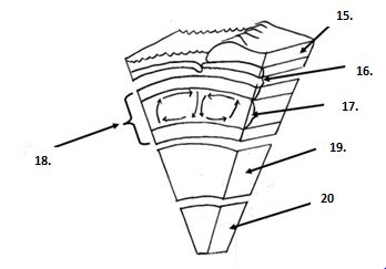
which layer is the lightest (least dense)?
lithosphere
mantle
core
mesosphere
True or false "hot rock rises, cooler rocks sink down"
true
false
In what mechanical layer of Earth do convection currents take place?
asthenosphere
lithosphere
inner core
what layer is the thinnest?
(a)
What is the role of a platform in oceanography?
To control ocean currents
To clean the ocean surface
To serve as a physical base for instruments
What does 'in-situ' mean in oceanographic data collection?
Data collected from space
Data collected directly in the water
Data collected directly in the water
Data collected from textbooks

What distinguishes a Remotely Operated Vehicle (ROV) from other platforms?
It allows real-time control and sampling via tether
It transmits data only after recovery
It floats on the surface
It operates without human input
What defines a cabled array?
A floating group of buoys
A satellite-based sensor system
A ship-based sampling method
A seafloor network transmitting data via underwater cables
What does a seismometer measure?
Atmospheric pressure
Ocean currents
Earthquake magnitude and frequency
Salinity
What is the starting point for measuring latitude?
The Prime Meridian
The International Date Line
The Equator
The North Pole
(a) lines run horizontally, parallel to the Equator, and are equidistant from each other.
How many minutes are in one degree of latitude?
15
60
180
360
Why might scientists choose a ship over a glider or mooring for data collection?
To collect physical samples like water or sediment
To monitor whale migration
To avoid satellite interference
To measure sea surface height remotely
What is the correct format for writing geographic coordinates?
Longitude first, then latitude
Degrees only, no direction
Latitude first, then longitude
Decimal degrees only
What does “sampling interval” mean in ocean data collection?
The distance between two sensors
The number of sensors on a platform
The depth range of a profiler
The time between consecutive measurements

