
Font size
 Worksheets
Plate Tectonics Unit Practice Test Questions
Total questions: 68
Worksheet time: 3hrs 24mins


Most tectonic plates have both oceanic and continental crust. How are these crust types different?
Oceanic is thinner and less dense than continental.
Continental is thinner than more dense than oceanic.
Continental is thicker and less dense than oceanic.
Oceanic is thicker and more dense than continental.


What is the force that moves the continents?
Conduction
Convection
Radiation
Conveyor belts

Originally the Continental drift theory was not well received by other scientist. Why?
There was a competing theory at the time that was more believable.
There was no data showing the continents ever moved.
The scientists did not know the force responsible for moving the continents.
The scientist presenting the data was unreliable.

Where did Wegener find plant fossils that today would not be able to survive on that type of land and extremely cold climate?
North America
Antarctica
China
India

True of False: The continents have always been where they are today
True
False

The difference between continental drift theory and plate tectonics theory is that plate tectonics includes seafloor spreading as an explanation of for moving the plates.
true
false
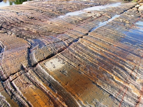

What evidence did Wegener use to support his theory?
Continents and fossils fitting together/matching-up like puzzle pieces
glacier scars and other climate evidence from temperature
mountain ranges and rocks line up across continents
all of the above

What are the two types of crust?
continental and oceanic
ocean and basin
lower and upper
thick and thin

How long ago is Pangaea believed to have existed?
200-300 million years ago
1000-2000 years ago
10,000-20,000 years ago
20-30 billion years ago

What type of plate is thicker?
continental
oceanic

The tectonic plates move very slowly, only a few __________per year.
meters
kilometers
centimeters
miles
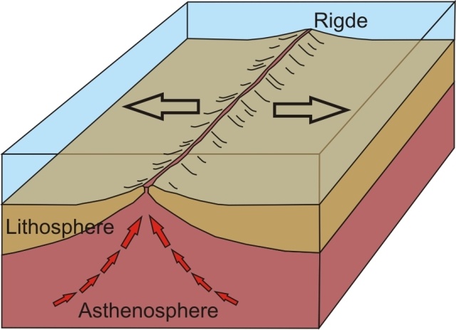


New oceanic crust (sea floor) is created at this boundary.
Divergent Oceanic
Divergent Continental
Convergent Oceanic
Transform

Oceanic crust (sea floor) is destroyed at this boundary.
Convergent Oceanic
Divergent Oceanic
Convergent Continental-Continental
Divergent Continental

The process where oceanic crust slides under another plate and is melted is called ___________.
seafloor spreading
subduction
continental drift
recycling

What two crustal features occur near every subduction zone?
Volcanoes and Trenches
Rift Valleys and Mid Ocean Ridges
Volcanoes and Rift Valleys
Mid Ocean Ridges and Trenches
When two continental plates converge (collide) what type of crustal feature is formed?
Mid Ocean Ridge
Subduction Zone
Rift Valley
Folded Mountains
The process that occurs at a divergent oceanic boundary that creates new crust (sea floor) is called?
Subduction
Seafloor Spreading
Continental Drift
Volcanism
If an earthquake occurs at the bottom of the ocean floor what could form as result?
Volcano
Tsumani
Tidal Wave
Hurricane
Aside from Earthquakes, what is the only thing you will find at transform boundaries?
Volcanoes
Subduction Zones
Folded Mountains
Fault lines
What is the only event associated with ALL plate boundaries?
Volcanoes
Earthquakes
Subduction
Deep Trenches
The only type of crust that will subduct if two plates converge is...
Oceanic
Continental
These are NOT plate boundary features. They are areas where hot mantle plumes push up through the lithospheric plates to create volcanic islands such as Hawaii.
Hotspots
Convergent Boundary
Divergent Boundary
Transform Boundary
The outermost, rigid layer of the earth, consisting of the earth's crust and upper part of the mantle is known as the ________________.
lithosphere
Pangaea
subduction zone
tectonic
Wegener
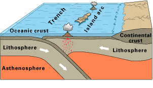
Look at this diagram of a plate boundary. Which statement BEST describes what is happening?
Tthe oceanic crust is melting.
The denser oceanic crust is subducting under the less dense oceanic crust.
Volcanic islands are forming.
The tectonic plates are moving away from each other.
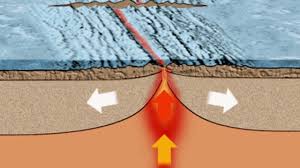
In sea-floor spreading, molten material rises from the mantle and erupts
along the edges of all the continents.
along mid-ocean ridges.
in deep-ocean trenches.
at the north and south poles.

The San Andreas Fault in California is known as an active earthquake area. What type of
boundary is it?
Converging
Diverging
Transform
Sea Floor Spreading
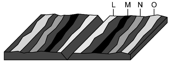
Look at the picture carefully.
Where would the oldest rock be found?

How is it possible for new crust to be formed without increasing the surface area of the Earth?


In some areas of the world, like California and Japan, earthquakes are a common occurrence. How can this best be explained?
The strong ocean currents are undermining both areas causing earthquakes.
Both areas are located near the edge of the Pacific Ocean, the unstable sand causes earthquakes.
Both areas are subjected to strong ocean wind and waves that causes earthquakes.
Both areas are on the boundary of active plates, the motion of the plates causes earthquakes.
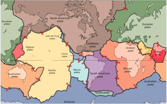
The map in the picture shows tectonic plate boundaries. This map would be useful in predicting the location of future
droughts (no rain)
hurricanes
earthquakes
tornadoes
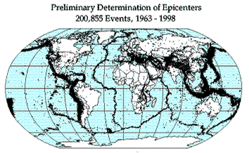
Earthquake epicenters (center of where the earthquakes started) were mapped for a 35 year period in the diagram above. The black dots indicate these epicenters. The black dots appear along what feature on Earth?
hot spots
plate boundaries
rift zones
sea floor spreading
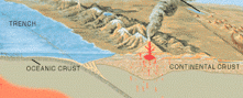

The 2004 Indian Ocean tsunami was caused by a shift in two plates that pushed one section of the sea floor under another section of the sea floor by 5 meters. What type of boundary is this?
divergent
convergent
transform
metamorphic
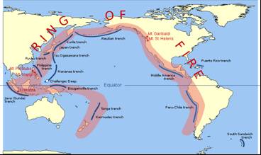
The image shows the Pacific Ring of Fire, a region of high tectonic activity. What evidence supports the theory that the tectonic activity of the region is due to the subduction of tectonic plates?
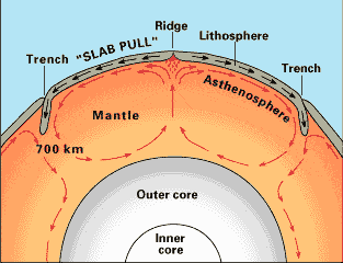
What is the source of energy that drives plate movement?
the subducton of the sea floor
the different densities of the oceanic and crustal plates
convection currents in the asthenosphere
the friction force between the plates that move past each other
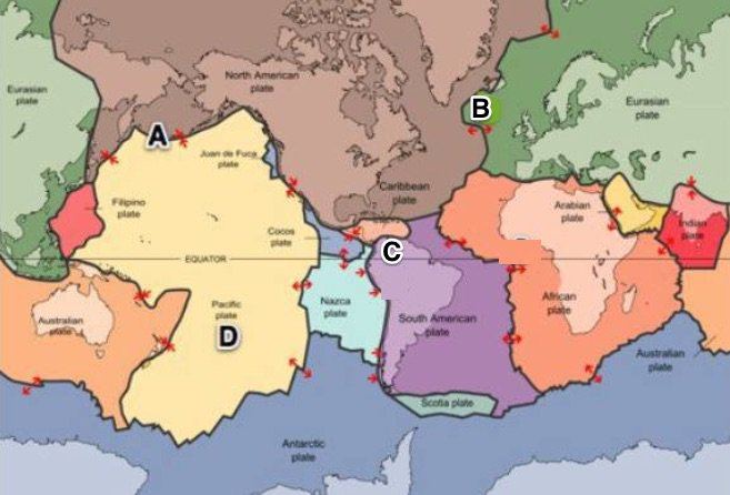
Where would sea floor spreading most likely occur?
At convergent boundaries (oceanic vs. oceanic)
At convergent boundaries (oceanic vs. continental)
At divergent plate boundaries (oceanic vs. oceanic)
At transform plate boundaries
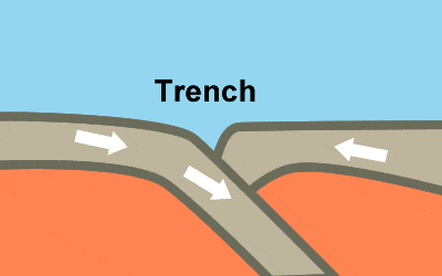
The Marianas Trench, where the Pacific Plate descends under the leading edge of the Eurasian Plate, is the deepest sea floor in the world. These ocean trenches form when two oceanic plates collide
and the older, less dense of the two plates rides over the edge of the older plate.
when convection currents in the mantle force the older plate downward.
and the younger, denser of the two plates, rides over the edge of the older plate.
and the plates are approximately the same age and density.

Why is it important to be aware of places prone to earthquakes?
to identify what crop must be stored
to identify when to evacuate
to locate where to go on vacation
to be ready for emergencies and build safer buildings

The Hawaiian islands have formed as the Pacific plate moves over...
a subduction zone
an ocean ridge
the Aleutian plate
a hot spot

The process of seafloor spreading...
creates new oceanic crust
destroys or recycles crust
creates new continental crust
creates old crust

The magnetic pattern or stripes of rocks on one side of the mid-ocean ridge are_____________.
the same as the rocks on the other side
younger than other side
much different pattern
at right angles to the ridge

seafloor spreading is occuring at the boundary between
Nazca Plate and South American Plate
Australian Plate and the Eurasian Plate
North American Plate and the Eurasion Plate.
China Plate and the Philippine Plate

The rocks on the ocean floor show evidence that the magnetism alternates North and South as you move along the sea-floor. This evidence of sea-floor spreading is reflected in the rocks on the ocean floor. The name for this evidence is called?
Crustal subtraction
Magnetic Reversals
plate motion
magnetic soldification

The area of magnetic force, around a magnet is known as its _________ ________
magnetic fan lines
magnetic declination
magnet tan lines
magnetic field

Magnets point north when Earth's magnetic field has this?
magnetic reversal
mid-ocean ridge
normal polarity
reversed polarity
seafloor spreading

Magnets point south when Earth's magnetic field has this
magnetic reversal
mid-ocean ridge
normal polarity
reversed polarity
seafloor spreading


Which of these is evidence that North America and Africa collided as Pangea formed about 270 million years ago.
Chesapeake Bay
Florida Peninsula
Appalachian Mountains
Great Dismal Swamp

Earth is approximately 4.5 billion years old, and
Pangaea is the only supercontinent to have existed. Before Pangaea, the Earth was all ocean.
True
False

Since tectonic plates are continuing to move, the continents will once again form a single supercontinent in the future.
True
False
Extend your thinking: Which is the most likely map of Earth 300 million years from now?


Choose TWO: Which force and characteristic of matter are most likely to be part of correct answers on the Virginia Earth Science SOL? (according to your teacher)
density
gravity
inertia
mass
volume

Which of the following are possible results of Earth's moving tectonic plates?
Mark all the answers that are correct.
earthquakes
glacier movement
mountain building
volcanism

