
 Worksheets
Regents Weather Exam Review
Total questions: 87
Worksheet time: 7hrs 15mins
Most weather comes from -
water
temperature
air masses
very large area
The temperature and humidity in an air mass stays about -
different
the same
100* C
An air mass gets its ____________ and __________ from the water or land it came from.
humidity, temperatue
size, shape
color, weight
weather, animals
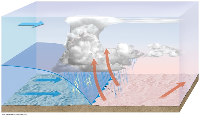
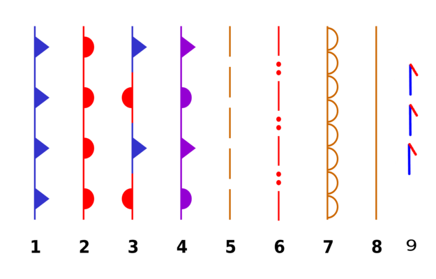
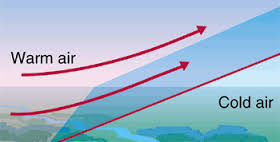
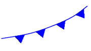


Which Fronts Bring Heavier Rain and Thunderstorms that can last a SHORT period of time?
Warm Front
Cold Front
Occluded Front
Stationary Front

On which map do the arrows correctly show the surface wind pattern for the high- and low-pressure centers shown on the northern part of the weather map of North America?
A
B
C
D
What is the relationship between a barometer reading and the weather?
A rise in barometer readings indicates stormy weather.
A drop in barometer readings indicates stormy weather.
A drop in barometer readings indicates cold weather.
A rise in barometer readings indicates warm weather.

What phase change takes place when a liquid turns into a solid?
melting
freezing
deposition
condensation

A substance's heating curve is shown in the graph. What is its boiling point? (Diagram B)
100 C
60 C
80 C
20 C
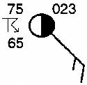
What is the dewpoint for the following station model?
10 ºF
23 ºF
65 ºF
75 ºF
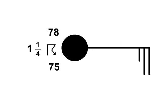
What is the present weather for the following station model?
rain
thunderstorms
drizzle
fog
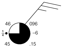
What is the amount of precipitation for the following station model?
.15 in
1/4 in
6 in
46 in
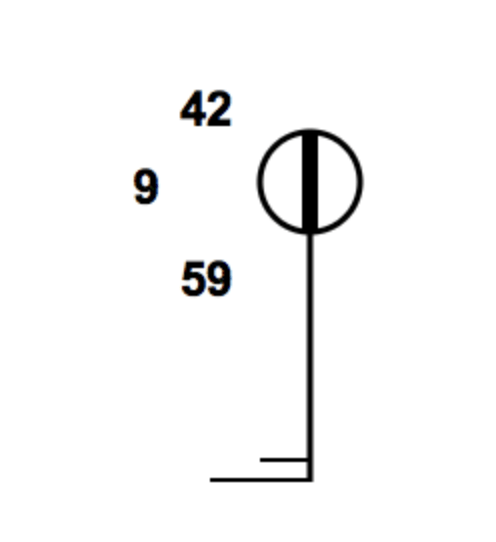
What is the visibility for the following station model?
1/2 mi
9 mi
42 mi
59 mi
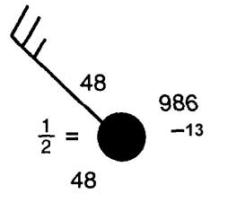
What is the wind direction for the following station model?
north
east
northwest
northeast
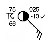
What is the wind speed for the following station model?
10 knots
15 knots
20 knots
25 knots
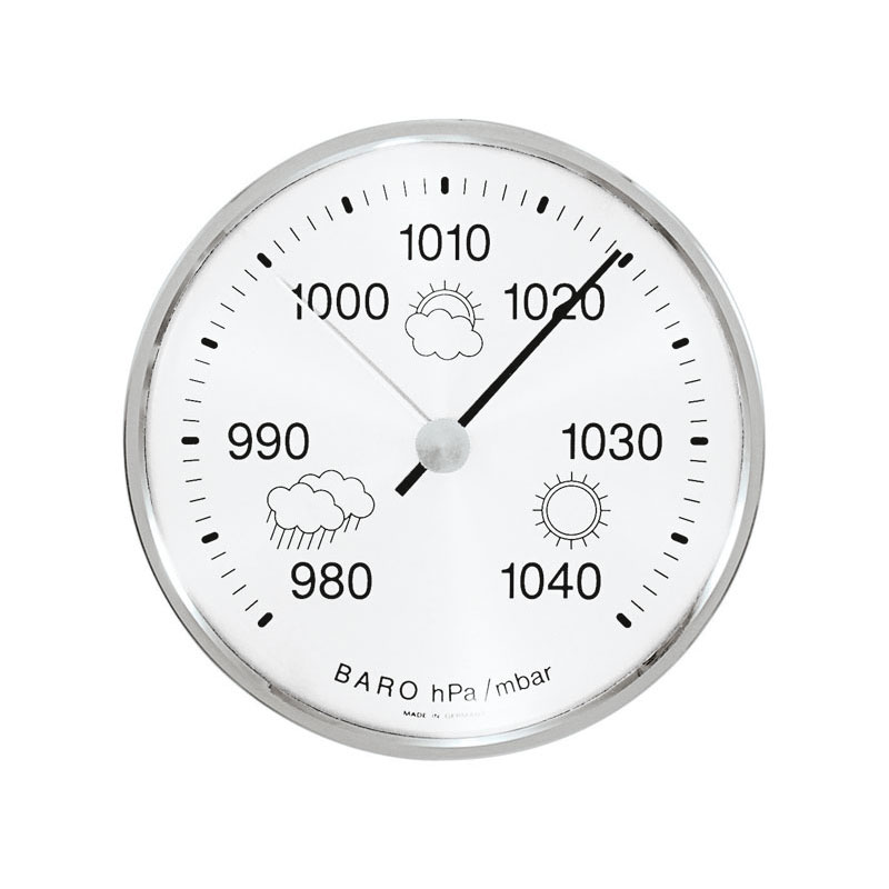
What is the station model code for a barometric pressure of 1019.5 mb?
101
195
019
119
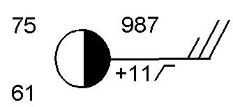
What is the barometric pressure for the following station model?
987 mb
998.7 mb
1098.7 mb
1098 mb
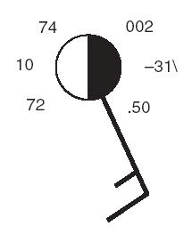
What is the barometric trend for the following station model?
steady 31 mb drop
steady 31 mb rise
steady 3.1 mb drop
steady 3.1 mb rise
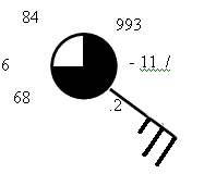
What is the amount of cloud cover for the following station model?
25%
50%
75%
100%
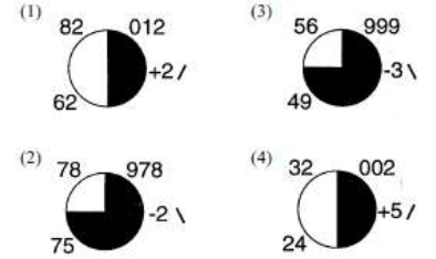
Which weather station shows the highest relative humidity?
1
2
3
4

What is the temperature?
37 degrees
55 degrees
138 degrees
3 degrees
Most storms are associated with high winds, heavy precipitation, and
high air pressure
slowly rising air pressure
low air pressure or cyclonic conditions
rapidly rising air pressure
Along the coast, the most dangerous aspect of hurricanes is the
lightning and hail
flooding by high waves
large central eye
suction effect of the funnel
The funnel of a tornado can "vacuum" up materials from Earth because of its extremely
high pressure
high temperature
low pressure
low wind speed
The most dangerous place to be during a thunderstorm is
in a car
under a high tree
in a ditch
in your basement
Which two are measures of how much moisture there is in the air?
dew point
wind chill
relative humidty
barometric pressure

Using your ESRT, what is the dew point if the dry-bulb temperature is 16° and the difference is 5° between wet-bulb and dry-bulb?
16°
5°
11°
7°

Using your ESRT, what is the relative humidity if the dry-bulb temperature is 6° and the difference between wet-bulb and dry bulb is 2°?
6%
72%
4%
46%
What instrument is used to measure dewpoint and relative humidity?
Thermometer
sling psychrometer
wind vane
Barometer

What is the relative humidity when the dry-bulb temperature is 16°C and the wet-bulb temperature is 14°C?
90%
80%
14%
13%
Which process most directly results in cloud formation?
transpiration
precipitation
radiation
condensation
The amount of moisture in the air is called
air pressure
humidity
precipitation
wind

The horizontal movement of air from and area of high pressure to an area of low pressure is called ____________.
wind
climate
high pressure
air pressure

All wind are caused by differences in ____________.
weather
precipitation
air pressure
climate
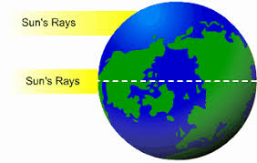
Most differences in air pressure are caused by _______________ heating of the atmosphere.
some
equal
unequal
great

Toward what direction does a West wind blow.
east
south
north
west

Wind direction is determined with a _____________.
thermometer
anemometer
satellite
wind vane

A wind that blows from an ocean or lake onto the land is known as a _________.
sea breeze
desert breeze
cold wind
warm wind

The flow of air from land to a body of water is called a ___________________
warm breeze
lake breeze
land breeze
wind breeze

Winds that blow over long distances in predictable patterns are called ____________.
seasonal winds
strong winds
global winds
local winds
What is air pressure?
the amount of pressure change occurring over a given distance
describes how Earth's rotation affects moving objects
the pressure exerted by the weight of air above
Which of these instruments is NOT used to measure air pressure?
mercury barometer
aneroid
anemometer
all of the above are used to measure air pressure
On a certain day, the isobars on a weather map are very close together over eastern North Carolina. To make the people of this area aware of possible risk to life and property in this situation, the National Weather Service should issue
a dense fog warning
a high wind advisory
a heat index warning
an air pollution advisory

What is the instrument used to measure air pressure?
anemometer
barometer
thermometer
hygrometer
Wind always blows from areas of ______ towards areas of _____ .
low pressure, high pressure
high pressure, low pressure
cold, warm
hot, hotter


Which graph best shows the general relationship between air pressure and altitude?


What is the average air pressure exerted by Earth's atmosphere at sea level, expressed in millibars and inches of mercury?
1013.25 mb and 29.92 in of Hg
29.92 mb and 1013.25 in of Hg
1012.65 mb and 29.91 in of Hg
29.91 mb and 1012.65 in of Hg
Air pressure is usually highest when the air is
cool and humid
cool and dry
warm and humid
warm and dry
An air pressure of 1023 millibars is equal to how many inches of mercury?
30.10
30.15
30.19
30.21
An air pressure of 29.65 inches of mercury is equal to
984.0 mb
999.0 mb
1001.0 mb
1004.0 mb

Base your answer on the diagram a weather instrument. Which weather variable is this instrument designed to measure?
visibility
relative humidity
dew point temperature
air pressure

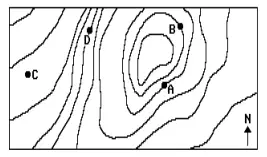
The map below represents a portion of an air-pressure field at the Earth's surface. At which position is wind speed lowest?
D
C
A
B

Areas on Map 1 that have a high temperature have a (a) pressure on Map 2,
while areas on Map 1 that have a low temperature have a (b) pressure on Map 2.
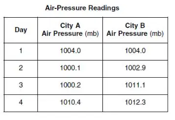
The table below shows air-pressure readings taken at two cities, in the same region of the United States, at noon on four different days. The wind speed in the region between cities A and B was probably the greatest at noon on day...
1
2
3
4
Closer isobars indicate a ________________________
strong pressure gradient and strong winds
weak pressure gradient and weak winds
strong pressure gradient and weak winds
weak pressure gradient and strong winds

Widely spaced isobars indicate:
strong pressure gradient and strong winds
weak pressure gradient and weak winds
strong pressure gradient and weak winds
weak pressure gradient and strong winds

Determine the winds associated with the image below:
Sea breeze
Land breeze
Country breeze
Valley breeze
Mountain breeze

What was the barometric pressure for location X on December 8?
The weather maps show the eastern United States on two consecutive days. Some isobars are labeled in millibars (mb). Letter X represents a location on Earth’s surface on December 8, 2009. What was the barometric pressure for location X on December 8?
1016 mb
1012 mb
1008 mb
1004 mb

Which information shown on the weather maps best indicates that wind speeds in New York State were greater on December 9 than on December 8?
Most of the weather changes occur in the ________ because this layer contains the most water vapor.
Thermosphere
Mesosphere
Troposphere
Stratosphere
What type of weather would you expect in high pressure?
sunny clear skies, cool, dry air
foggy skies, light rain, moist, cold air
sunny skies, humid, warm air
cloudy skies, strong winds, wet air
An isotherm shows air pressure and an isobar shows temperature
They both show types of precipitation you can expect in your area
An isotherm shows temperature and an isobar shows air pressure
A high pressure area will bring nice weather while a low pressure area brings storms
Land cools slower than water, so the air above water is cooler.
Water cools faster than land, so the air above land is warmer.
Water cools slower than land, so the air above water is warmer.
The map below represents a portion of an air-pressure field at the Earth's surface. At which position is wind speed lowest?
D
C
A
B
How are air masses form into clouds? Clouds are form when
cold moist air rises and then cools
warm moist rises, expands and then cools
cold air reaches the lifted condensation level
The temperature at which the air become completely saturated with water vapor is called
humidity
dew point
air density
air pressure

How does the climate of Seattle compare with the climate of spokane?
Spokane- cool and humid
Spokane- cool and dry
Spokane- warm and dry
Spokane- warm and humid

The curved paths of the planetary winds are a result of

Compared to the climate conditions on the leeward side of this mountain range, the conditions on the windward side are usually

Base your answer on the weather map below, which shows the locations of a high-pressure center (H) and a low-pressure center (L) over a portion of North America. The isolines indicate surface air pressures.
The arrows on which map show the most likely path in which these two pressure centers will move over the next few days?


Which map shows the most likely location of clouds associated with these pressure centers?


Which map best represents the surface wind pattern associated with high-pressure and low-pressure systems in the Northern Hemisphere?



