
NEW
Font size
 Worksheets
6.10D Geological Events
Total questions: 70
Worksheet time: 42mins
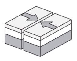


Which layer of the Earth is solid iron and nickel?
Mantle
Crust
Inner Core
Outer core

A map is provided that presents information on a certain region of the Earth. Based on the information on the map, at which location are mountains most likely to form?
A
B
C
D

A map is provided that shows the location of the Aleutian Islands in comparison to some of Earth’s tectonic plates is provided. Based on the information provided, which of the following is most likely a feature of the Aleutian Islands?
The climate is getting older.
They were formed by volcanic activity.
These islands are the oldest on Earth.
Earthquakes do not occur there

Peru and Chile are part of South America, which sits on the South American tectonic plate. The Nazca plate is moving toward the South American plate. It is pushed downward, which causes it to slide under the South American plate. Based on this information, what feature could we expect to see off the coast of Peru and Chile?
new Continent formation
Poor fishing conditions
Deep ocean trench
Severe tropical storms

This is the type of boundary that occurs when tectonic plates move apart.
convergent
divergent
transform
none of the above

When one piece of crust gets pushed under another one, it called:
radial fracture
lingering
subduction
leverage

The tectonic plate labeled with the letter G is the ___________ plate.
Indo-Australian
African
Pacific
South American

What is the name of plate #5?
Cocos
South American
Juan de Fuca
Pacific

What is the name of plate #1?
Cocos
African
Juan de Fuca
Eurasian

What is the name of plate #6?
Antarctic
Arabian
Australian
Pacific

What is the name of plate #2?
Antarctic
Arabian
North American
South American

What is the name of plate #4?
Antarctic
Arabian
North American
African

What is the name of plate #7?
Eurasian
Antarctic
Philippine
Scotia

What is the name of plate #3?
Eurasian
Pacific
Philippine
Scotia

What is the name of plate #8?
Eurasian
Indian
North American
Scotia

What is the name of plate #5?
Cocos
Indo-Australian
Juan de Fuca
Pacific

What is the name of plate #1?
Cocos
Indo-Australian
Juan de Fuca
Pacific

What is the name of plate #6?
Antarctic
Arabian
North American
Pacific

What is the name of plate #2?
Antarctic
Arabian
North American
South American
What is the name of plate #4?
Antarctic
Arabian
North American
South American
What is the name of plate #7?
Eurasian
African
Philippine Sea
Scotia
What is the name of plate #3?
Eurasian
Nazca
Philippine Sea
Scotia
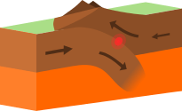

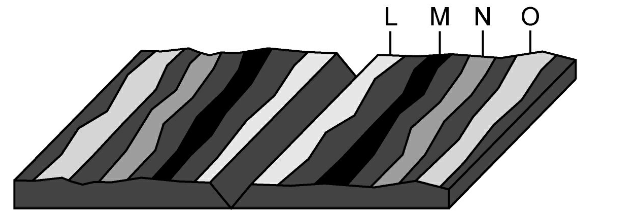

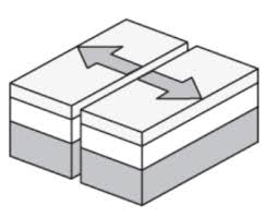


Describe the most likely relationship between these mountains and nearby tectonic plates.
The mountains are probably formed by earthquakes
The mountains are probably formed by the movement of glaciers
The mountains are probably located near the edge of 2 tectonic plates.
The mountains are probably formed by running water.

Is there a pattern to the locations of earthquakes and volcanoes around the globe?
No, earthquakes and volcanoes are random.
Yes, earthquakes and volcanoes usually occur near the boundaries of tectonic plates.
yes, earthquakes and volcanoes usually occur in the middle of tectonic plates.
No, earthquakes and volcanoes usually occur under water.

Most earthquakes tend to occur at which location?
The central regions of very large continents
Groups of islands farthest from any continents
The boundaries between continents and oceans
The steep slopes of the very oldest mountains
A map is provided that presents information on a certain region of the Earth. Based on the information on the map, at which location are mountains most likely to form?
A
B
C
D
A map is provided that shows the location of the Aleutian Islands in comparison to some of Earth’s tectonic plates is provided. Based on the information provided, which of the following is most likely a feature of the Aleutian Islands?
The climate is getting older.
They were formed by volcanic activity.
These islands are the oldest on Earth.
Earthquakes do not occur there

The Ring of Fire is an area where a large number of earthquakes and volcanic eruptions occur. What claim can be made about the Ring of Fire from this information?
It is the only place on Earth where earthquakes can happen.
The edges of the tectonic plates are moving in this area.
It represents the areas where tectonic plates are the thickest.
It has been getting larger since Earth first formed.
Peru and Chile are part of South America, which sits on the South American tectonic plate. The Nazca plate is moving toward the South American plate. It is pushed downward, which causes it to slide under the South American plate. Based on this information, what feature could we expect to see off the coast of Peru and Chile?
new Continent formation
Poor fishing conditions
Deep ocean trench
Severe tropical storms

A force caused the continents to drift apart over time. Once scientists figured out what that force was, the theory of plate tectonics was born! The image above shows what Geologists think the Earth looked like millions of years ago. What name was given to this land mass.
Plate Tectonics
Oceana
Pangea
North America

Tectonic plates float on top of the ________
Crust
Mantle
Inner Core
Outer Core

We live in an area without many earthquakes because _____
We live near a major fault line
We live near the boundary of 2 tectonic plates
We live near the middle of the North American Plate
We live near the Pacific Plate
What is a divergent boundary?
one big continent or land mass
a plate boundary where two plates move toward each other
a plate boundary where two plates move away from each other
the point on Earth's surface directly above an earthquake's focus
What is a convergent boundary?
The theory that pieces of Earth's lithosphere are in constant motion, driven by convection currents in the mantle.
One big continent or land mass.
Th process by which oceanic crust sinks beneath a deep-ocean trench and back into the mantle at a convergent plate boundary.
A plate boundary where two plates move toward each other.
What is subduction?
The theory that the Earth's continents have moved over geologic time.
Developed Continental Drift Theory
One big continent or land mass
The process by which oceanic crust sinks beneath a deep trench and back into the mantle at a convergent plate boundary.
Which statement best describes the geologic process that is most likely responsible for the formation of mountains?
They are along a transform plate boundary that is no longer active, so erosion is creating deep valleys.
They are along a transform plate boundary in which plates are currently moving side by side, causing earthquakes and faults.
They are along a plate boundary in which plates are currently converging, causing uplift and steep slopes.
They are along a plate boundary in which plates diverged in the distance past, allowing new rock to build up.
A mid-ocean RIDGE is located at the boundary of two tectonic plates. Which diagram correctly models the relative plate motion on each side of a mid ocean ridge?


Rift valleys can form when fractures in Earth's crust widen. The valley walls slowly move at a rate of only a few millimeters a year. Which of these best describes the type of tectonic activity that forms rift valleys?
Rift valleys form where a continental plate moves under an oceanic plate
Rift valleys form where a plat slides horizontally past another plate
Rift valleys form where two plates move away from each other
Rift valleys form where an oceanic plate moves under another oceanic plate

The San Andreas fault is a transform fault. The map below shows a student's approximation of where the fault line crosses through the United States. Students were asked to make maps predicting which way land would most likely move over thousands of years.


A mid-ocean ridge separates the Pacific plate and the Nazca plate off the western coast of South America. Which statement best describes the relative motions of the Pacific and Nazca plates?
The Pacific and Nazca plates are moving to the east
The Pacific and Nazca plates are both moving to the west
The Pacific plate is moving to the west, and the Nazca plate is moving to the east
The Pacific plate is moving to the east, and the Nazca plate is moving to the west

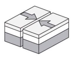
The image shows a plate boundary. Arrows have been added to indicate the movement of the plates. What plate boundary feature is also shown?
A ridge formed by an inactive convergent boundary
A valley forming at an active divergent boundary
A fault forming at an active transform boundary
A volcano formed by an active transform boundary

The map shows the locations of four active volcanoes in the Caribbean Sea. What do these volcanoes indicate about plate tectonics in the region?
The volcanoes form an island arc, indicating a converging plate boundary
The volcanoes form a line, indicating a diverging plate boundary
Two plates are moving past each other, causing faulting and magma formation
Two plates are moving apart, creating new seafloor

The model below shows two continental plates. The folded mountains in this model form at which type of plate boundary?
transform boundary
divergent boundary
subduction boundary
convergent boundary
What are the 3 types of plate boundaries?
convergent, transform, and divergent
close, near, far
andesitic, rhyolitic, basaltic
crustal, mantle, asthenosphere

