
 Worksheets
Plate Tectonics and weather maps
Total questions: 57
Worksheet time: 52mins
Tectonic plates consist of
continental crust
mesospheric crust
both continental and oceanic crust
oceanic crust
The scientist who developed the big idea called "sea-floor spreading"
Alfred Wedgener
Harry Hess
Edward Dutton
Ortelius
Pangaea was an ancient supercontinent made up of...
America, Greenland, and Europe
Antarctica, India, and America
all of Earth’s continents
South Africa, India, Australia, and South America
Why did no one believe Wegener's thoery that the continents were once together?
He could not explain HOW the continents moved
He didn't have evidence
His data was wrong
He didn't use the right technology to gather data
The movement of the tectonic plates is caused by
the rotation of the Earth
convection currents in the Asthenosphere
the gravity of the iron-nickel core
the Moho discontinuity
The fact that similar fossils are found on both sides of the ocean is evidence of
magnetic reversal
global positioning
continental drift
oceanic drift

Who is the scientist who proposed Continental Drift Theory?

Alfred Wegener named his single supercontinent ____________, which means "all Earth" in ancient Greek.
Pandora
Gandowandaland
Pangea
Percia
The Theory of Pangea
The Theory of Moving Continents
The Theory of Continental Drift
The Theory of Techtonic Plates

What type of fossils were noticed by Wegener to be found on two different continents?

True or False: The continental plates move so quickly that we can feel them.
True
False

Most geologists think that the movement of Earth's tectonic plates is caused by
the rotation of the Earth.
the Earth's magnetic field.
subduction.
convection currents.

When plates collide we get ________.
crumbles
volcanos
trenches
mountain ranges


Which layer of Earth flows slowly and causes the crust to move?
Crust
Mantle
Inner Core
Outer core

What is the correct order (starting from the surface) of Earth’s layers?
crust, outer core, inner core, mantle
mantle, outer core, inner core, crust
crust, mantle, outer core, inner core
outer core, inner core, crust, mantle

When tectonic plates slide against each other causing the earth to move.

Subduction means.....
one plate goes under another plate
two plates slide past each other
two plate collide and form folded mountains

Sea-floor spreading explains how.....
new crust is created at a divergent boundary
volcanoes are formed on continents
deep sea trenches are formed
An opening on the Earth's crust through which hot molten rock flows out from deep inside the Earth.
Volcano
Fault line
Fold
Crater

What do we call an area where more then two plates interact in different ways
plate boundary zones
hot spots
convergent boundaries
subduction
Which of the following is the name of the ancient supercontinent formed 280 Million Years ago.
Pangea
Gondwanda
Laurasia
Neverland

The earthquakes experienced in California are related to tectonic plates because these catastrophic events are the result of -
two tectonic plates sliding past each other.
tectonic plates melting as they slide into the mantle.
tectonic plates being weathered over time.
two tectonic plates pulling away from each other.
A mid-ocean RIDGE is located at the boundary of two tectonic plates. Which diagram correctly models the relative plate motion on each side of a mid ocean ridge?


The San Andreas fault is a transform fault. The map below shows a student's approximation of where the fault line crosses through the United States. Students were asked to make maps predicting which way land would most likely move over thousands of years.


The image shows a plate boundary. Arrows have been added to indicate the movement of the plates.What plate boundary feature is also shown?
A ridge formed by an inactive convergent boundary
A valley forming at an active divergent boundary
A fault forming at an active transform boundary
A volcano formed by an active transform boundary

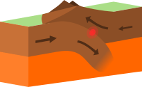
The diagram shows a model of the movement of two tectonic plates. When the plates collide, on plate often moves below the other plate. The rising magma that can result from this type of plate movement may produce-
fossil layers
volcanic islands
deep-sea sediment
seafloor spreading


Which student correctly identified the geologic process that formed the Himalayan mountains?
1
2
3
4


You would expect to see clouds forming and possible precipitation
in Utah (the H)
in Florida
in Nebraska (between the H and the L)
in Indiana

Why do you see precipitation near the L? (select 2 answers)
because that is low pressure and that is where air rises, forming clouds
because that is where air is falling and it brings rain with it
because southern Ohio is always rainy this time of year
because the cold front is meeting the warm front which forces warm air to rise rapidly forming clouds

What type of weather is Minneapolis most likely experiencing?
light/drizzly rain
severe thunderstorms
sunny skies
cloudy skies, light precipitation

Why does city "B" have clear skies?
It is in North America
There is not a front moving through city "B"
Clouds do not form in the West
It is located near a high pressure system

