
NEW
Font size
 Worksheets
Earthquakes
Total questions: 72
Worksheet time: 2hrs 24mins
A seismic station recorded the P-waves, but no S-waves, from an earthquake because S-waves were
absorbed by Earth's outer core
transmitted only through liquids
Which table below correctly shows the characteristics of seismic waves when they reach liquid material?


The magnitude of an earthquake is a number that represents the
arrival time of the first P-wave
difference in arrival times between P- and S-waves
energy released by an earthquake
distance to the epicenter
Why are P-waves received, but S-waves are not received by seismic stations located on the opposite side of Earth from an earthquake epicenter?
S-waves travel slower than P-waves.
S-waves travel faster than P-waves.
Earth's inner core absorbs S-waves
Earth's outer core absorbs S-waves.
The first S-wave of an earthquake took 10 minutes 40 seconds to travel to a seismic station from the epicenter of an earthquake. How much time did it take for the first P-wave to travel that distance?
4 minutes and 40 seconds
6 minutes
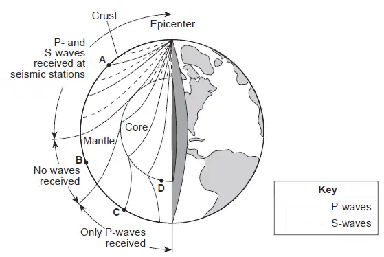
Base your answer to the question on the diagram below and on your knowledge of Earth science. The diagram represents a cut-away view of Earth's interior and the paths of some of the seismic waves produced by an earthquake that originated below Earth's surface. Points A, B, and C represent seismic stations on Earth's surface. Only P-waves were recorded at seismic station C because P-waves travel
only through Earth's interior, and S-waves travel only on Earth's surface
fast enough to penetrate the core, and S-waves travel too slowly
through iron and nickel, while S-waves cannot
through liquids, while S-waves cannot
Seismic station A is 5000 kilometers from the epicenter. What is the difference between the arrival time of the first P-wave and the arrival time of the first S-wave recorded at this station?
2 minutes and 20 seconds
6 minutes and 40 seconds
8 minutes and 20 seconds
15 minutes
What is the approximate P-wave travel time from an earthquake if the P-wave arrives at the seismic station 8 minutes before the S-wave?
4 minutes and 20 seconds
6 minutes and 30 seconds
10 minutes
A P-wave takes 5 minutes to travel from the epicenter of an earthquake to a seismic station. Approximately how many minutes will it take an S-wave to travel that same distance?
15 min
12 min
9 min
4 min
The epicenter of an earthquake is located 6,500 kilometers away from a seismic station. If the first S-wave arrived at this seismic station at 1:30 p.m., at what time did the first P-wave arrive?
1:20 PM
1:22 PM
1:38 PM
1:40 PM
Once a tsunami warning is issued, which action should residents of a city take to prevent loss of life?
evacuate to higher ground
board up windows
go into their basements
get under a sturdy desk or table
The distance from the epicenter of the March 1964 earthquake to Crescent City is 2600 kilometers. How long did it take the first P-wave to reach Crescent City?
3 minutes 20 seconds
4 minutes 10 seconds
5 minutes 0 seconds
9 minutes 10 seconds
A strong earthquake that occurs on the ocean floor could result in the formation of
a tsunami
ocean current
a fault
a topographic line
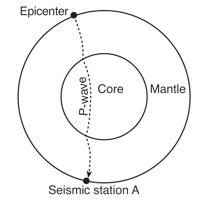
The cross section of Earth below shows a P-wave moving away from an earthquake epicenter to seismic station A. No S-waves arrive directly at seismic station A because
some parts of the core are liquid
S-waves travel too slowly
the distance to seismic station A is too great
seismic station A is located on glacial ice
An earthquake's magnitude can be determined by
analyzing the seismic waves recorded by a seismograph
calculating the depth of the earthquake faulting
calculating the time the earthquake occurred
comparing the speed of P-waves and S-waves
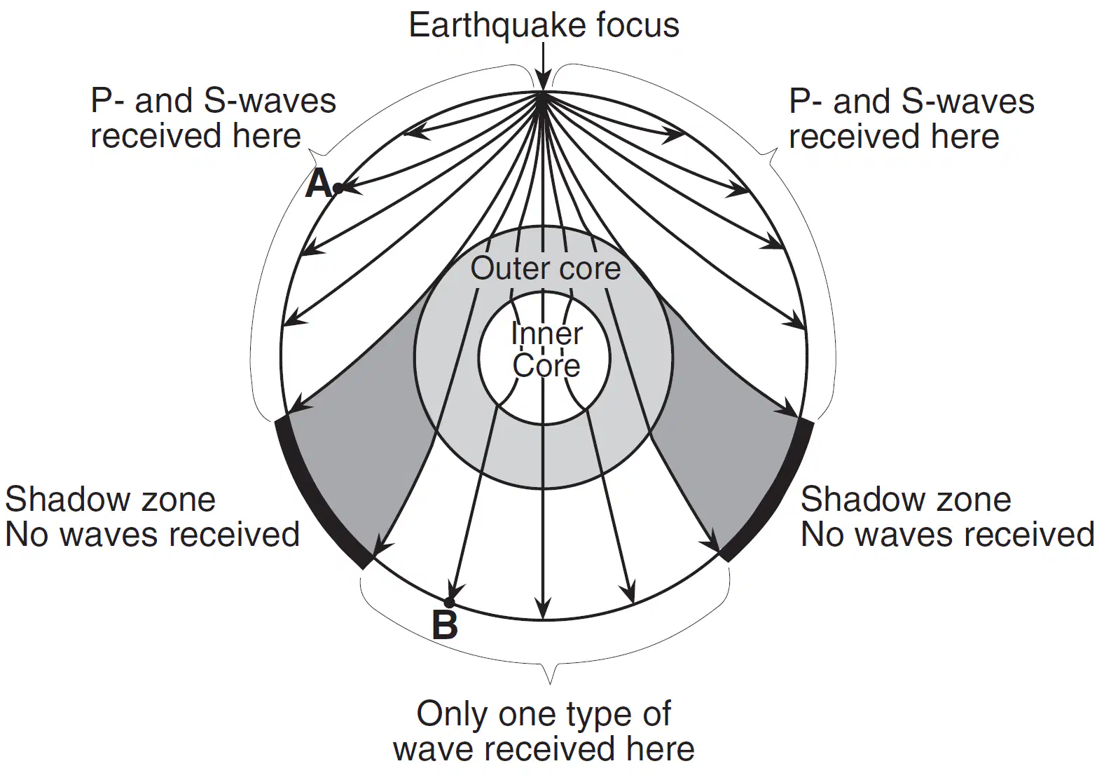
Base your answer on the cross-sectional view of Earth below, which shows seismic waves traveling from the focus of an earthquake. Points A and B are locations on Earth's surface. Which statement best explains why only one type of seismic wave was recorded at location B?
S-waves cannot travel through the liquid outer core
S-waves cannot travel through the liquid inner core.
P-waves cannot travel through the solid outer core.
P-waves cannot travel through the solid inner core.
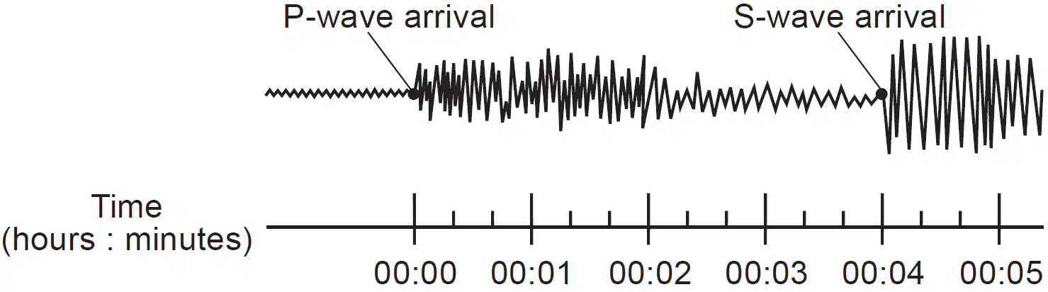
A seismic station is located 2000 kilometers from the epicenter of an earthquake. Which seismogram indicates the correct time difference between the arrival of the first P-wave and the first S-wave at this station?


A seismic station 4000 kilometers from the epicenter of an earthquake records the arrival time of the first S-wave at 1:05:40 p.m. At what time did the first P-wave arrive at this station?
12:58:40 p.m.
1:00:00 p.m.
1:05:40 p.m.
The first S-wave reaches a seismic station 22 minutes after an earthquake occurred. How long did it take the first P-wave to reach the same seismic station?
8 minutes 50 seconds
10 minutes 00 seconds
12 minutes 00 seconds
An earthquake occurs at 10:05 a.m. At 10:09 a.m., the first P-wave from this earthquake is detected at a seismic station. Approximately how many kilometers (km) from the epicenter is this seismic station located?
1000 km
2000 km
2600 km
5600 km
The first P-wave of an earthquake travels 5600 kilometers from the epicenter and arrives at a seismic station at 10:05 a.m. At what time did this earthquake occur?
9:49 a.m.
9:56 a.m.
10:02 a.m.
A seismic P-wave is recorded at 2:25 p.m. at a seismic station located 7600 kilometers from the epicenter of an earthquake. At what time did the earthquake occur?
2:05 p.m.
2:11 p.m.
2:14 p.m.

Base your answer on the graph below and on your knowledge of Earth science. The diagram represents a portion of Earth's interior. Letters A, B, and C represent interior layers. The graph shows the velocity of P-waves and S-waves at various depths in Earth's interior. Which layers of Earth's interior are represented by letters A and B?
A is the crust and B is the rigid mantle.
A is the lithosphere and B is the asthenosphere
A is the asthenosphere and B is the crust.
A is the rigid mantle and B is the lithosphere
Which two Earth layers are separated by the Moho boundary?
rigid mantle and plastic mantle
outer core and stiffer mantle
stiffer mantle and asthenosphere
crust and rigid mantle
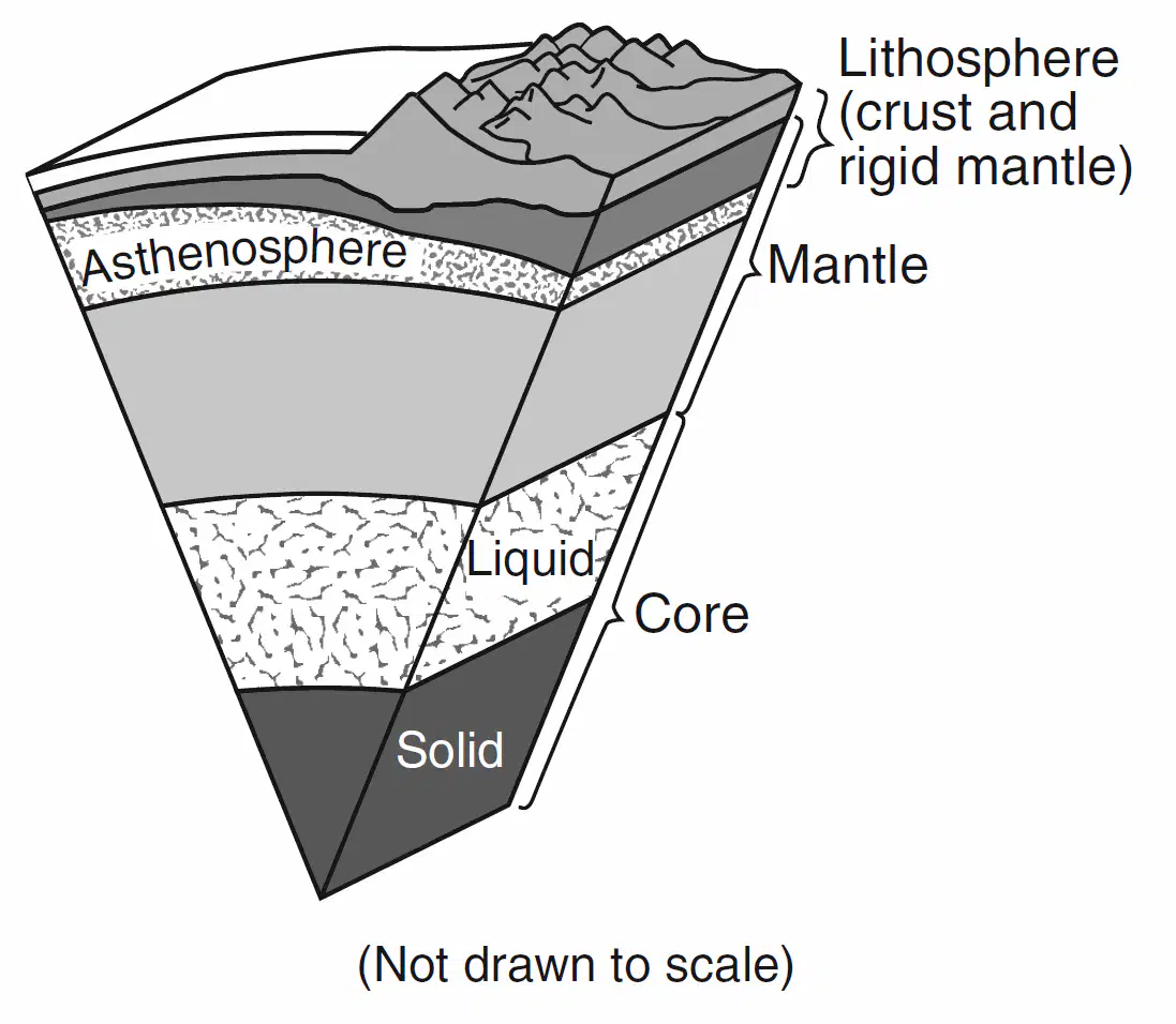
A model of Earth's internal structure is shown below. Analysis of which type of data led to the development of this model?
seismic waves
depth of Earth's oceans
electromagnetic radiation
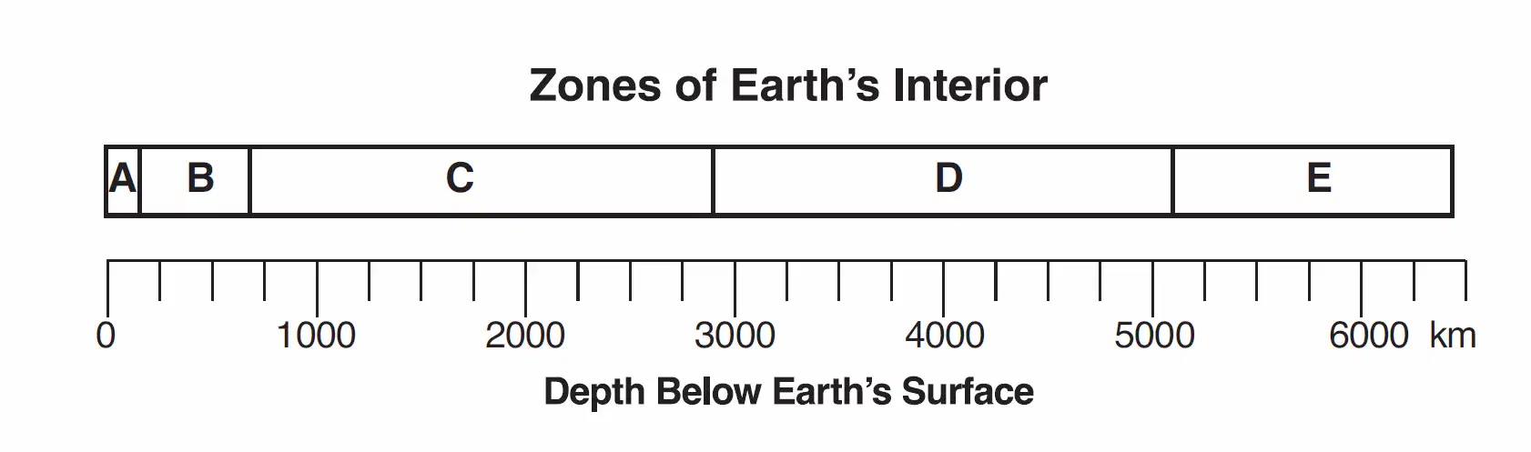
Base your answer on the diagram below, which represents zones of Earth's interior, identified by letters A through E. The scale shows depths below Earth's surface, measured in kilometers. The Moho is a boundary located in zone
A
B
E
D
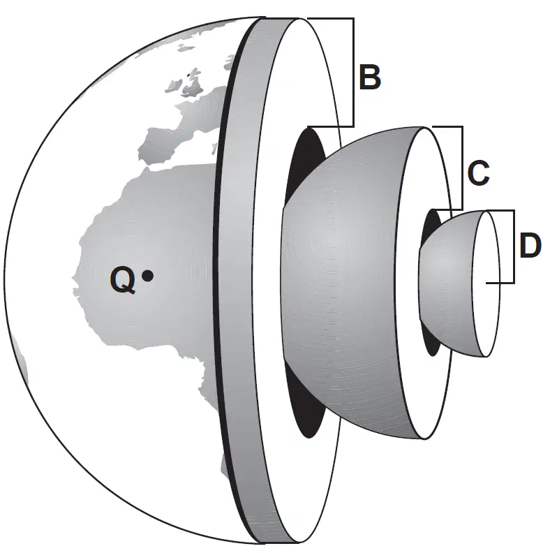
Base your answer on the diagram of Earth shown below. Letters B, C, and D represent layers of Earth. Letter Q represents a location on Earth's surface. Which letter best represents Earth's mantle?
Q
B
C
D

Base your answer on the cross section below, which shows the paths of seismic waves traveling from an earthquake epicenter through the different layers of Earth's interior. No P-waves or S-waves are received in the shadow zone because
P-waves are absorbed and S-waves are refracted by Earth's outer core
P-waves are refracted and S-waves are absorbed by Earth's outer core
both the P-waves and S-waves are refracted by Earth's outer core
Which part of Earth's interior is inferred to have convection currents that cause tectonic plates to move?
rigid mantle
asthenosphere
outer core
inner core
Compared to the thickness and density of the continental crust, the relative thickness and density of Earth's oceanic crust are
thinner and less dense
thinner and more dense
thicker and less dense
thicker and more dense
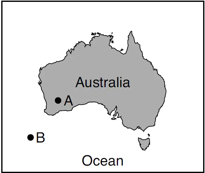
The map below shows the continent of Australia. Letters A and B indicate locations on Earth's crustal surface. Compared to the crust at A, the crust at B is
thinner and less dense
thinner and more dense
thicker and less dense
thicker and more dense
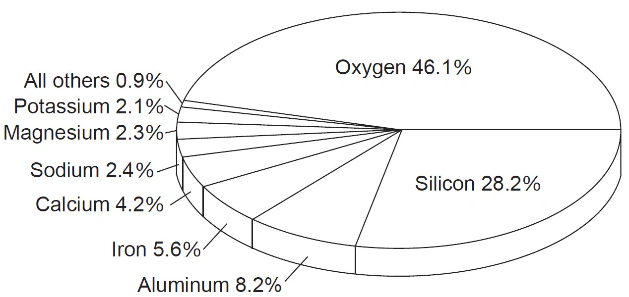
The pie graph below represents the composition, in percent by mass, of the chemical elements found in an Earth layer. The composition of which Earth layer is represented by the pie graph?
crust
outer core
hydrosphere
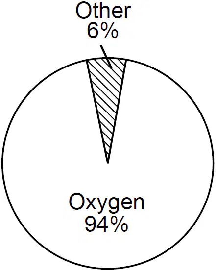
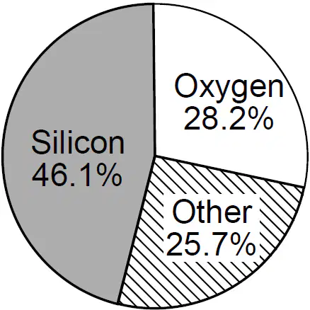
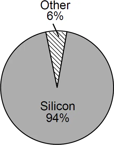
Which graph best represents the percentage by mass of elements of Earth's crust?

Earth's crustal bedrock at the Mid-Atlantic Ridge is composed mostly of
basalt, with a density of 2.7 g/cm3
basalt, with a density of 3.0 g/cm3
granite, with a density of 2.7 g/cm3
granite, with a density of 3.0 g/cm3
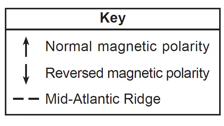
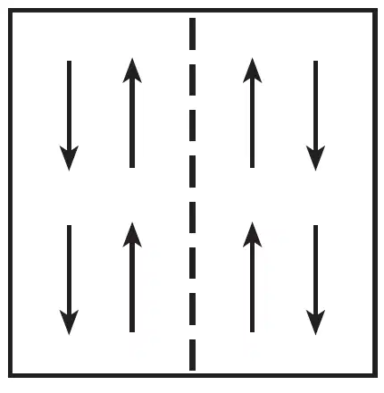
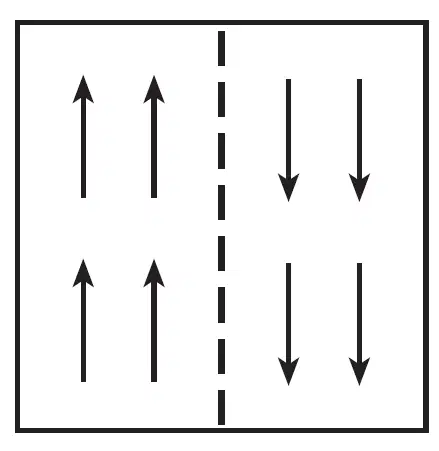
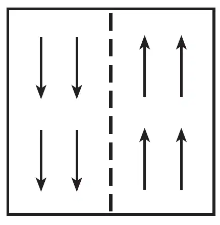
Which map best represents the pattern of magnetic polarity in the minerals of ocean-floor bedrock on each side of the Mid-Atlantic Ridge?

The interior of Earth between a depth of 5200 kilometers and 6300 kilometers is inferred to be composed mostly of
silicon and iron
silicon and oxygen
iron and lead
iron and nickel
Which factor is responsible for the circulation of convection currents occurring in the hydrosphere, troposphere, and mantle?
radioactive decay
solar radiation
density differences
planetary winds
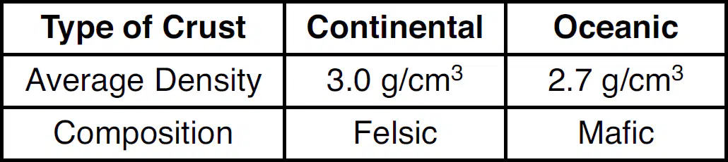
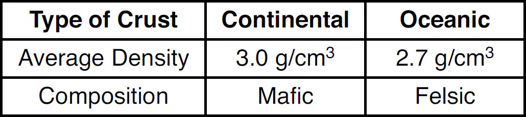
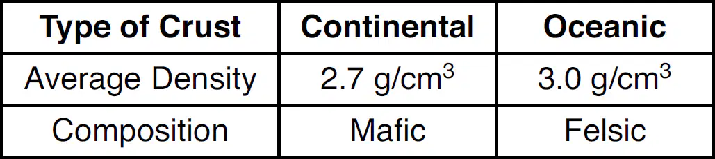
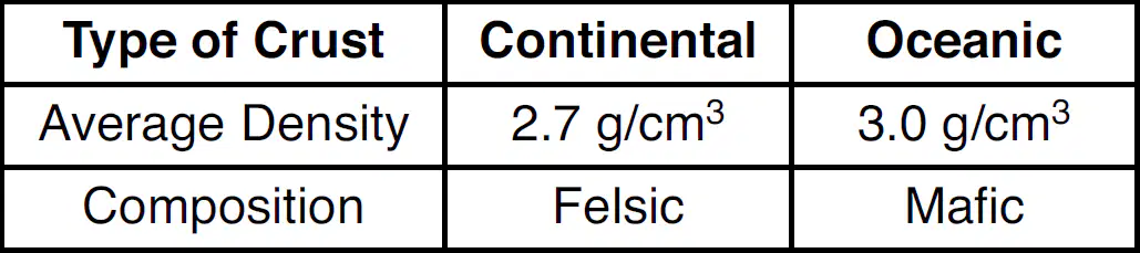
Which table correctly matches the average density and composition of continental and oceanic crusts?
The pressure at the interface between Earth's outer core and inner core is inferred to be
0.2 million atmosphere
1.5 million atmospheres
3.1 million atmospheres
3.6 million atmospheres

The diagram below shows the cutaway views of the inferred interior layers of the planets Mercury and Venus. What is the reason for the development of the interior layers of these two planets?
Impact events added the mantle rock above the cores.
Heat from the Sun melted the surface rocks to form the mantles above the cores.
Gravity separated the cores and mantles due to their density differences.
Which layer of Earth's interior is inferred to be composed mostly of iron and nickel, and has an interior temperature that is greater than its melting point?
plastic mantle
stiffer mantle
outer core
inner core
Which layer of Earth's interior is inferred to be composed of solid iron and nickel?
asthenosphere
stiffer mantle
outer core
inner core

The photograph below shows the bedrock structure of an outcrop. Which process is responsible for the folding of this bedrock?
volcanic activity
earthquake activity
crustal movement
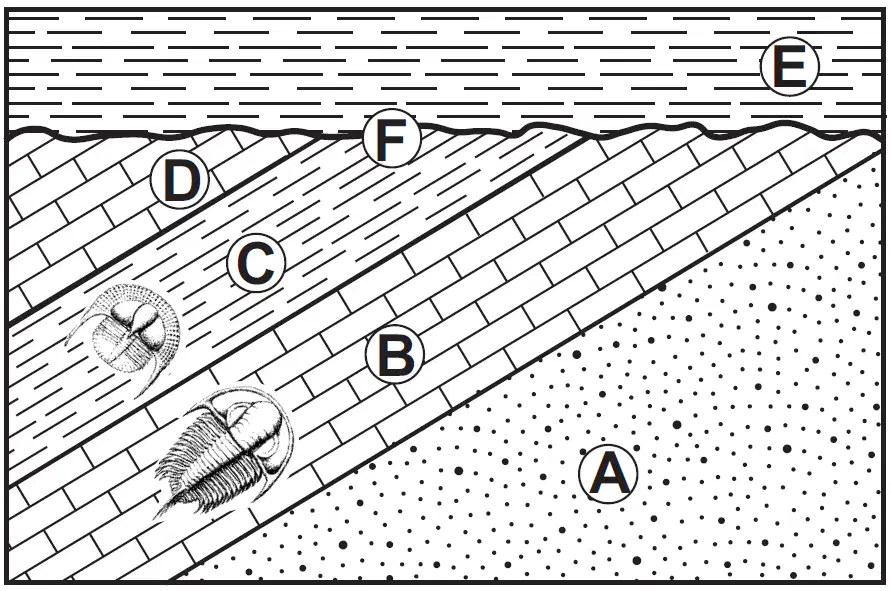
Base your answer on the cross section below and on your knowledge of Earth science. Letters A through E represent rock units. Letter F represents a geologic feature. Some layers contain index fossils. Which geologic principle could be used to support the inference that rock layers A through D experienced crustal movement?
original horizontality
crosscutting relationships
contact metamorphism
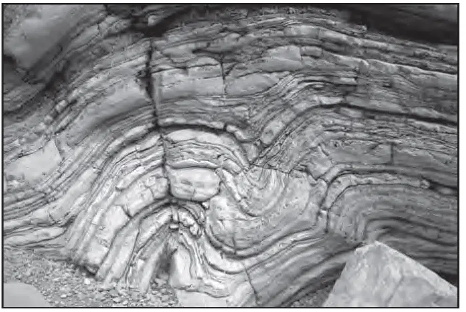
The photograph below shows the bedrock structure of a limestone outcrop. Which process is responsible for the deformation of this bedrock?
folding
weathering
mass movement
volcanic activity
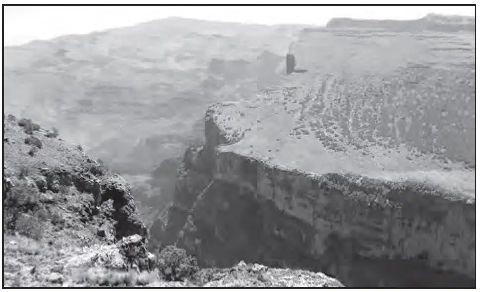
The photograph below shows the East African Rift Valley in Africa. Which tectonic movement of Earth's crust is most likely responsible for this feature?
convergence of continental crust
convergence of oceanic crust
divergence of continental crust
divergence of oceanic crust
Which two hot spots are located on the same tectonic plate?
Tasman and Easter Island Hot Spots
Hawaii and Yellowstone Hot Spots
Iceland and Bouvet Hot Spots
Canary Islands and St. Helena Hot Spots
The Mariana Trench is Earth's deepest oceanic trench. This trench formed as the Pacific Plate was
overriding the Philippine Plate
overriding the Eurasian Plate
subducting under the Philippine Plate
subducting under the Eurasian Plate

The aerial photograph below shows two streams that have been displaced by tectonic movement along the San Andreas fault. The arrows show the relative direction of movement along the fault. This movement occurred along which type of plate boundary?
convergent
divergent
transform
complex

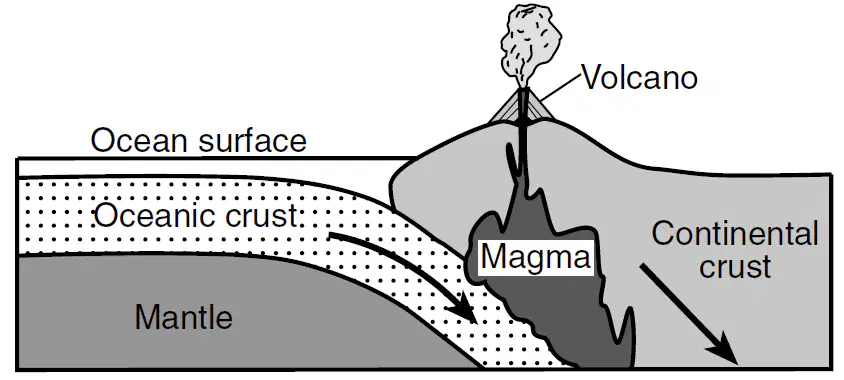
The cross section below represents a lithospheric plate boundary. In which diagram do the arrows show the relative directions of plate movement at this type of plate boundary?
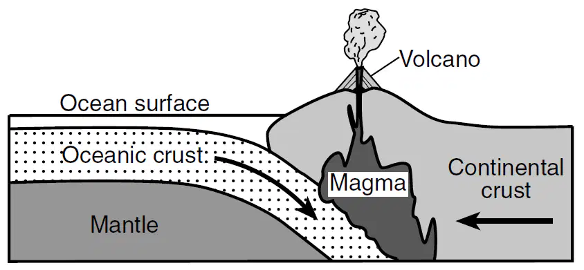
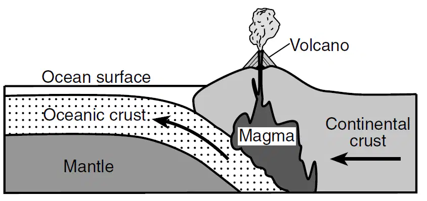
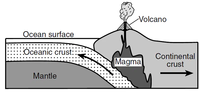
The Hawaiian Islands were formed as a result of
lava flowing over Earth's surface where two tectonic plates move apart
an oceanic plate moving over a mantle hot spot
two oceanic plates colliding to form an island arc
tectonic plates sliding past each other
Which mantle hot spot is correctly matched to its overlying tectonic plate?
Tasman Hot Spot-Pacific Plate
Canary Island Hot Spot-Eurasian Plate
St. Helena Hot Spot-South American Plate
Yellowstone Hot Spot-North American Plate

The map shows the location of the epicenter of a major earthquake that occurred about 1700 years ago. Point A represents a location on a tectonic plate boundary. Plates X and Y represent major tectonic plates. The island of Crete; the Anatolian Plate, which is a minor tectonic plate; and the Hellenic Trench have been labeled. Arrows indicate the relative directions of plate motion. What are the names of the major tectonic plates X and Y?
X = Eurasian Plate; Y = African Plate
X = Eurasian Plate; Y = Arabian Plate
X = Indian-Australian Plate; Y = African Plate
X = Indian-Australian Plate; Y = Arabian Plate

The map shows the location of the epicenter of a major earthquake that occurred about 1700 years ago. Point A represents a location on a tectonic plate boundary. Plates X and Y represent major tectonic plates. The island of Crete; the Anatolian Plate, which is a minor tectonic plate; and the Hellenic Trench have been labeled. Arrows indicate the relative directions of plate motion. Which type of plate boundary is represented at point A?
divergent
convergent
transform
complex
Which two mantle hot spots are located at mid-ocean ridges?
Iceland and Yellowstone
Galapagos and Tasman
St. Helena and Hawaii
Easter Island and Bouvet
Which tectonic feature is associated with a complex or uncertain plate boundary?
Southwest Indian Ridge
East African Rift
Mariana Trench

On the map below, points A through D represent locations on Earth's surface. Which location is positioned over a mantle hot spot?
A
B
C
D
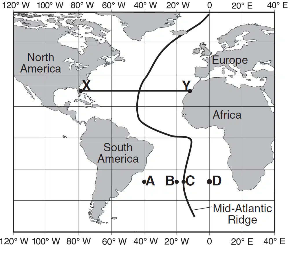
Base your answer on the map of the Mid-Atlantic Ridge shown below. Points A through D are locations on the ocean floor. Line XY connects locations in North America and Africa. In which cross section do the arrows best show the convection occurring within the asthenosphere beneath line XY?
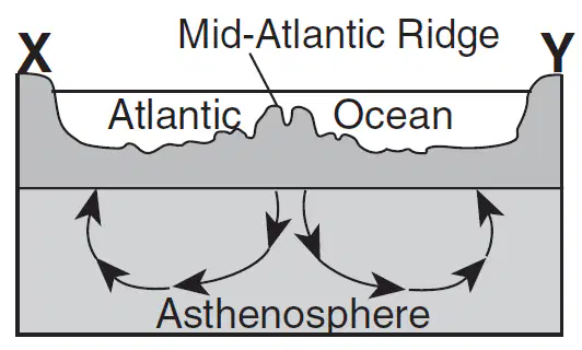
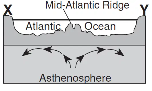
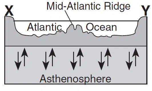
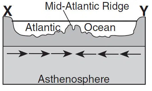
Which observation about the Mid-Atlantic Ridge region provides the best evidence that the seafloor has been spreading for millions of years?
The bedrock of the ridge and nearby seafloor is igneous rock.
The ridge is the location of irregular volcanic eruptions.
Several faults cut across the ridge and nearby seafloor.
Seafloor bedrock is younger near the ridge and older farther away.
Which two tectonic plates are separated by a mid-ocean ridge?
Indian-Australian and Eurasian
Indian-Australian and Pacific
North American and South American
North American and Eurasian
In which Earth layer are most convection currents that cause seafloor spreading thought to be located?
crust
asthenosphere
outer core
inner core
Which geologic feature is composed of the youngest crustal bedrock?
Peru-Chile Trench
Mid-Atlantic Ridge
Adirondack Mountains
San Andreas Fault

Base your answer on the cross section below and on your knowledge of Earth science. Letters A through E represent rock units. Letter F represents a geologic feature. Some layers contain index fossils. During the Ordovician Period when layer C was forming, most of the United States was inferred to be located
slightly north of the equator
slightly south of the equator
at the North Pole
Which landmass is moving northward with Australia as part of the same tectonic plate'?
India
North America
South America
Which map best indicates the probable locations of continents 100 million years from now if tectonic plate movement continues at its present rate and direction?


Based on the theory of plate tectonics, it is inferred that over the past 250 million years North America has moved toward the
northwest
northeast
southeast
southwest
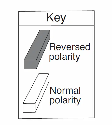
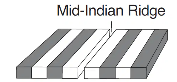
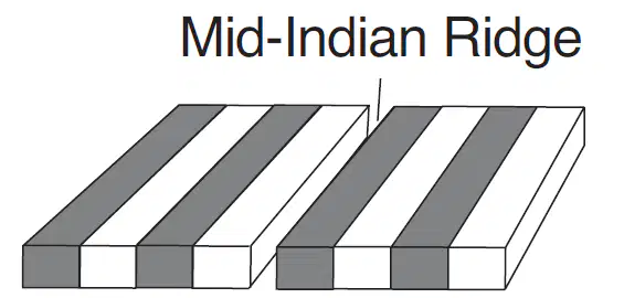
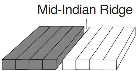
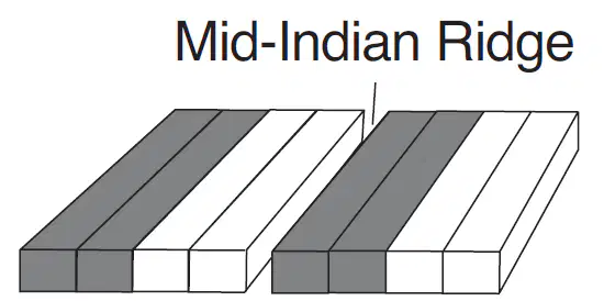
Which diagram best represents the polarity of the magnetic field preserved in the ocean-floor bedrock found on both sides of the Mid-Indian Ridge?
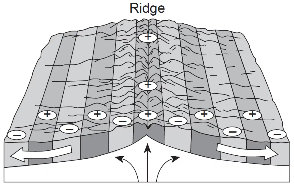
The block diagram below represents the present ocean floor. The white arrows show the movement of the ocean floor and the black arrows show the movement of the asthenosphere. Which characteristic of the ocean-floor bedrock is best described by the plus and minus symbols in the diagram?
plus = older age; minus = younger age
plus = younger age; minus = older age
plus = reversed magnetic polarity; minus = normal magnetic polarity
plus = normal magnetic polarity; minus = reversed magnetic polarity
Alternating parallel bands of normal and reversed magnetic polarity are found in the basaltic bedrock on either side of the
Mid-Atlantic Ridge
Yellowstone Hot Spot
San Andreas Fault
Peru-Chile Trench

Base your answer on cross section below, which shows an underwater mountain range in the Atlantic Ocean. The oceanic bedrock is composed mainly of basalt. Points X and Y are locations in the bedrock that have been diverging at the same rate. The movement of the North American Plate and Eurasian Plate is shown by the two arrows. Which statements best describe the age and magnetic orientation of the basalts found at locations X and Y?
The basalt at location X is younger than the basalt at location Y. Both locations have the same magnetic orientation.
The basalts at locations X and Yare the same age. Both locations have the same magnetic orientation.
The basalts at locations X and Y are the same age. Location X has normal magnetic orientation and location Y has reversed magnetic orientation.
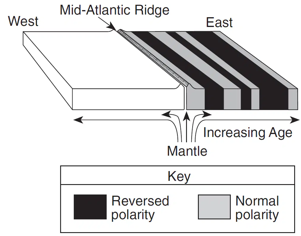
Which diagram best shows the magnetic pattern and relative age of the igneous bedrock on the west side of the ridge?
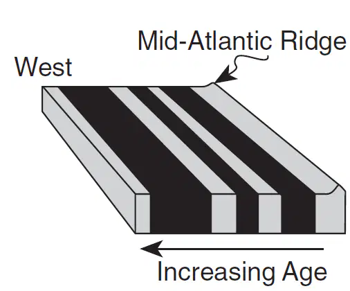
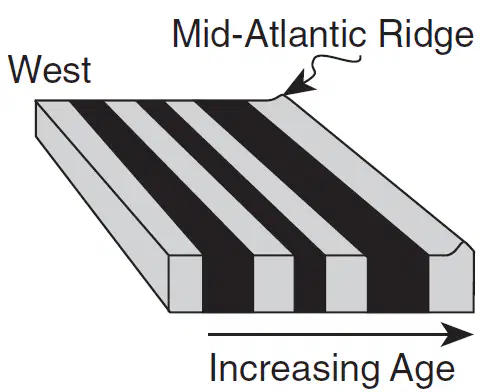
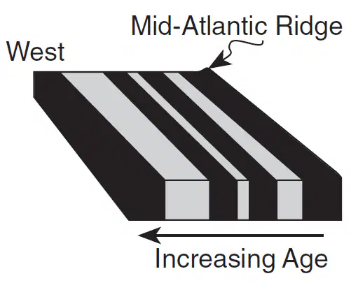

Earth's magnetic field has reversed itself several times during the past. This pattern of magnetic reversal is best preserved in
metamorphic bedrock in mountain ranges
bedrock with fossils containing radioactive carbon-14
layers of sedimentary bedrock of the Grand Canyon
igneous bedrock of the oceanic crust

